
Brooklyn-Queens Greenway
Encyclopedia
The Brooklyn-Queens Greenway is a bicycling and pedestrian path connecting parks and roads in the New York City
boroughs
of Brooklyn
and Queens
, connecting Coney Island
in the south to Fort Totten in the north, on Long Island Sound
. The route connects major sites in the two boroughs, such as the New York Aquarium
, Brooklyn Museum
, the Brooklyn Botanic Garden
, the New York Hall of Science
and Citi Field.
The Greenway is being developed under the joint auspices of the New York City Department of Transportation
and the New York City Department of Parks and Recreation
. As of 2007, the majority of the route is in parks or otherwise segregated
from motor traffic. The remainder is implemented as painted lanes or signed routes in streets.
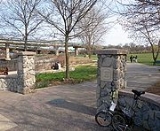
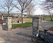
The 40-mile (64 km) route includes portions of existing bike routes in Prospect Park
, and along Eastern Parkway
and Ocean Parkway
in Brooklyn, and in Alley Pond Park
, Cunningham Park
, Forest Park
, Kissena Park
and Ridgewood Reservoir
in Queens.
 The northern terminus of the Brooklyn-Queens Greenway is Little Bay Park, in the shadow of the Throgs Neck Bridge
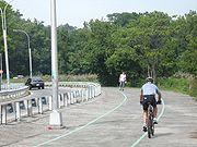
. Passing the entrance to Fort Totten Park, the Greenway runs parallel to the Cross Island Parkway
and is known as "Joe Michaels Mile." After crossing busy Northern Boulevard, the route becomes a well signed bike route along quiet residential streets, climbing to the former Long Island Motor Parkway
.
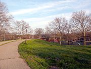
The LIMP section of the Greenway is above-grade and most is closed to motor vehicle traffic, making for a peaceful and tranquil ride. Using the LIMP, a branch of the Greenway goes eastward into Alley Pond Park
to picnic tables, tennis courts and locker rooms. This eastern branch proceeds to the Alley Pond Adventure Course and the Winchester Boulevard bike lane.
The westward or main line of the Greenway makes its way through Cunningham Park
and Kissena Park
, and eventually goes around the south side of Queens Botanical Garden
on streets, crossing the Whitestone Expressway on its own high overpass into Flushing Meadows-Corona Park
.
Once in Flushing Meadows, the Greenway runs along the eastern shores of both Meadow and Willow Lakes, exiting the park onto Jewel Avenue. The route continues on quiet residential streets such as Hoover and Collidge Avenues, and on more heavily trafficked ones such as Main Street, and crosses Queens Boulevard
. The Greenway enters Forest Park (Queens)
at the Overlook and continues down Forest Park Drive passing the Urban Park Ranger station at Woodhaven Boulevard, the George Seuffert, Sr. Bandshell, and the Forest Park Golf Course. Exiting the park, the Greenway continues along parts of Cooper Avenue and other local streets to Highland Park and the Ridgewood Reservoir.
, the Brooklyn leg of the Greenway uses various local streets in East New York to connect to the Eastern Parkway. From here to the end, there is little mixing with motor traffic for the 3 miles (5 km) Eastern Parkway bike route, 2 miles (3 km) through Prospect Park, and the 5 mile (8 km) Ocean Parkway to the southern terminus in Coney Island
. The Brooklyn portion is less hilly than the Queens portion, except in Prospect Park.
New York City
New York is the most populous city in the United States and the center of the New York Metropolitan Area, one of the most populous metropolitan areas in the world. New York exerts a significant impact upon global commerce, finance, media, art, fashion, research, technology, education, and...
boroughs
Borough (New York City)
New York City, one of the largest cities in the world, is composed of five boroughs. Each borough now has the same boundaries as the county it is in. County governments were dissolved when the city consolidated in 1898, along with all city, town, and village governments within each county...
of Brooklyn
Brooklyn
Brooklyn is the most populous of New York City's five boroughs, with nearly 2.6 million residents, and the second-largest in area. Since 1896, Brooklyn has had the same boundaries as Kings County, which is now the most populous county in New York State and the second-most densely populated...
and Queens
Queens
Queens is the easternmost of the five boroughs of New York City. The largest borough in area and the second-largest in population, it is coextensive with Queens County, an administrative division of New York state, in the United States....
, connecting Coney Island
Coney Island
Coney Island is a peninsula and beach on the Atlantic Ocean in southern Brooklyn, New York, United States. The site was formerly an outer barrier island, but became partially connected to the mainland by landfill....
in the south to Fort Totten in the north, on Long Island Sound
Long Island Sound
Long Island Sound is an estuary of the Atlantic Ocean, located in the United States between Connecticut to the north and Long Island, New York to the south. The mouth of the Connecticut River at Old Saybrook, Connecticut, empties into the sound. On its western end the sound is bounded by the Bronx...
. The route connects major sites in the two boroughs, such as the New York Aquarium
New York Aquarium
The New York Aquarium is the oldest continually operating aquarium in the United States, having opened in Castle Garden in Battery Park, Manhattan in 1896. Since 1957, it has been located on the boardwalk in Coney Island, Brooklyn. The aquarium is managed by the Wildlife Conservation Society as...
, Brooklyn Museum
Brooklyn Museum
The Brooklyn Museum is an encyclopedia art museum located in the New York City borough of Brooklyn. At 560,000 square feet, the museum holds New York City's second largest art collection with roughly 1.5 million works....
, the Brooklyn Botanic Garden
Brooklyn Botanic Garden
Brooklyn Botanic Garden is a botanical garden in the borough of Brooklyn in New York City. Located near the Prospect Heights, Crown Heights, and Park Slope neighborhoods, the garden includes a number of specialty "gardens within the Garden," plant collections, and the Steinhardt Conservatory,...
, the New York Hall of Science
New York Hall of Science
The New York Hall of Science occupies one of the few remaining structures of the 1964 New York World's Fair in Flushing Meadow-Corona Park in the borough of Queens in New York City. Today, it stands as New York City's only hands-on science and technology center...
and Citi Field.
The Greenway is being developed under the joint auspices of the New York City Department of Transportation
New York City Department of Transportation
The New York City Department of Transportation is responsible for the management of much of New York City's transportation infrastructure...
and the New York City Department of Parks and Recreation
New York City Department of Parks and Recreation
The City of New York Department of Parks & Recreation is the department of government of the City of New York responsible for maintaining the city's parks system, preserving and maintaining the ecological diversity of the city's natural areas, and furnishing recreational opportunities for city's...
. As of 2007, the majority of the route is in parks or otherwise segregated
Segregated cycle facilities
Segregated cycle facilities are marked lanes, tracks, shoulders and paths designated for use by cyclists from which motorised traffic is generally excluded...
from motor traffic. The remainder is implemented as painted lanes or signed routes in streets.
The 40-mile (64 km) route includes portions of existing bike routes in Prospect Park
Prospect Park (Brooklyn)
Prospect Park is a 585-acre public park in the New York City borough of Brooklyn located between Park Slope, Prospect-Lefferts Gardens, Kensington, Windsor Terrace and Flatbush Avenue, Grand Army Plaza and the Brooklyn Botanic Garden...
, and along Eastern Parkway
Eastern Parkway (Brooklyn)
Eastern Parkway is a major boulevard that runs through a portion of the New York City borough of Brooklyn. The road begins at Grand Army Plaza and extends east, running parallel to Atlantic Avenue, along the crest of the moraine that separates northern from southern Long Island, to Ralph Avenue...
and Ocean Parkway
Ocean Parkway (Brooklyn)
Ocean Parkway is a broad boulevard in the west central portion of the borough of Brooklyn in New York City.-Route description:Ocean Parkway extends over a distance of about five miles , running almost north to south from the vicinity of Prospect Park to Brighton Beach...
in Brooklyn, and in Alley Pond Park
Alley Pond Park
Alley Pond Park is the second-largest public park in Queens, New York. It occupies , most of it acquired and cleared by the city in 1929, as authorized by a resolution of the New York City Board of Estimate in 1927. The park is bordered to the east by Douglaston, to the west by Bayside, to the...
, Cunningham Park
Cunningham Park
Cunningham Park is a park in the New York City borough of Queens. The park lies between the Grand Central Parkway to the south and the Long Island Expressway, and is bifurcated by the Clearview Expressway...
, Forest Park
Forest Park (Queens)
Forest Park is a park in the New York City borough of Queens. It has an area of 538 acres . The park is operated and maintained by the New York City Department of Parks and Recreation.-History:...
, Kissena Park
Kissena Park
Kissena Park is a large park located in the neighborhood of Flushing in the New York City borough of Queens, along Kissena Creek which formerly flowed into the Flushing River. It is bordered on the west by Kissena Boulevard; on the north by Rose, Oak, Underhill, and Lithonia Avenues; on the east...
and Ridgewood Reservoir
Ridgewood Reservoir
Ridgewood Reservoir is a decommissioned 19th century reservoir that sits on the Brooklyn-Queens border and is part of Highland Park. The reservoir and park are bounded on the north by the Jackie Robinson Parkway, on the south by Highland Boulevard, on the west by Vermont Place and on the east by...
in Queens.
Queens
Throgs Neck Bridge
The Throgs Neck Bridge is a suspension bridge opened on January 11, 1961, which carries Interstate 295 over the East River where it meets the Long Island Sound. The bridge connects the Throggs Neck section of the Bronx with the Bay Terrace section of Queens...
. Passing the entrance to Fort Totten Park, the Greenway runs parallel to the Cross Island Parkway
Cross Island Parkway
Cross Island Parkway, also known as the 100th Infantry Division Parkway, is a parkway within New York State. The parkway is a part of the Belt Parkway system that runs along the perimeter of the borough of Queens in New York City...
and is known as "Joe Michaels Mile." After crossing busy Northern Boulevard, the route becomes a well signed bike route along quiet residential streets, climbing to the former Long Island Motor Parkway
Long Island Motor Parkway
The Long Island Motor Parkway , also known as the Vanderbilt Parkway and Motor Parkway, was the first roadway designed for automobile use only. It was privately built by William Kissam Vanderbilt with overpasses and bridges to remove intersections...
.
The LIMP section of the Greenway is above-grade and most is closed to motor vehicle traffic, making for a peaceful and tranquil ride. Using the LIMP, a branch of the Greenway goes eastward into Alley Pond Park
Alley Pond Park
Alley Pond Park is the second-largest public park in Queens, New York. It occupies , most of it acquired and cleared by the city in 1929, as authorized by a resolution of the New York City Board of Estimate in 1927. The park is bordered to the east by Douglaston, to the west by Bayside, to the...
to picnic tables, tennis courts and locker rooms. This eastern branch proceeds to the Alley Pond Adventure Course and the Winchester Boulevard bike lane.
The westward or main line of the Greenway makes its way through Cunningham Park
Cunningham Park
Cunningham Park is a park in the New York City borough of Queens. The park lies between the Grand Central Parkway to the south and the Long Island Expressway, and is bifurcated by the Clearview Expressway...
and Kissena Park
Kissena Park
Kissena Park is a large park located in the neighborhood of Flushing in the New York City borough of Queens, along Kissena Creek which formerly flowed into the Flushing River. It is bordered on the west by Kissena Boulevard; on the north by Rose, Oak, Underhill, and Lithonia Avenues; on the east...
, and eventually goes around the south side of Queens Botanical Garden
Queens Botanical Garden
The Queens Botanical Garden began as part of the 1939 New York World's Fair in Queens. After the fair, the garden expanded to take up a larger portion of Flushing Meadows Park...
on streets, crossing the Whitestone Expressway on its own high overpass into Flushing Meadows-Corona Park
Flushing Meadows-Corona Park
Flushing Meadows-Corona Park, often referred to as Flushing Meadow Park, Flushing Meadows Park or Flushing Meadows, is a public park in New York City. It contains the USTA Billie Jean King National Tennis Center, the current venue for the U.S...
.
Once in Flushing Meadows, the Greenway runs along the eastern shores of both Meadow and Willow Lakes, exiting the park onto Jewel Avenue. The route continues on quiet residential streets such as Hoover and Collidge Avenues, and on more heavily trafficked ones such as Main Street, and crosses Queens Boulevard
Queens Boulevard
Queens Boulevard is a major thoroughfare in the New York City boroughs of Manhattan and Queens connecting communities from Midtown Manhattan to Jamaica...
. The Greenway enters Forest Park (Queens)
Forest Park (Queens)
Forest Park is a park in the New York City borough of Queens. It has an area of 538 acres . The park is operated and maintained by the New York City Department of Parks and Recreation.-History:...
at the Overlook and continues down Forest Park Drive passing the Urban Park Ranger station at Woodhaven Boulevard, the George Seuffert, Sr. Bandshell, and the Forest Park Golf Course. Exiting the park, the Greenway continues along parts of Cooper Avenue and other local streets to Highland Park and the Ridgewood Reservoir.
Brooklyn
After exiting Highland ParkHighland Park, Brooklyn
Highland Park is a park located on the Brooklyn-Queens border. The name is also applied to the Brooklyn neighborhood to its south, commonly regarded as part of the East NY neighborhood....
, the Brooklyn leg of the Greenway uses various local streets in East New York to connect to the Eastern Parkway. From here to the end, there is little mixing with motor traffic for the 3 miles (5 km) Eastern Parkway bike route, 2 miles (3 km) through Prospect Park, and the 5 mile (8 km) Ocean Parkway to the southern terminus in Coney Island
Coney Island
Coney Island is a peninsula and beach on the Atlantic Ocean in southern Brooklyn, New York, United States. The site was formerly an outer barrier island, but became partially connected to the mainland by landfill....
. The Brooklyn portion is less hilly than the Queens portion, except in Prospect Park.