

Long Island Motor Parkway
Encyclopedia
William Kissam Vanderbilt
William Kissam Vanderbilt was a member of the prominent American Vanderbilt family. He managed railroads and was a horse breeder.-Biography:...
with overpasses and bridges to remove intersections. It opened in 1908 as a toll road and closed in 1938 when it was taken over by the State of New York in lieu of back taxes. Parts of the parkway survive today in sections of other roadways and as a bicycle trail in Queens, New York.
History
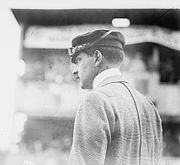
William Kissam Vanderbilt IIWilliam Kissam Vanderbilt II
William Kissam Vanderbilt II was a motor racing enthusiast and yachtsman and a member of the prominent United States Vanderbilt family.-Biography:...
, the great-grandson of Cornelius Vanderbilt
Cornelius Vanderbilt
Cornelius Vanderbilt , also known by the sobriquet Commodore, was an American entrepreneur who built his wealth in shipping and railroads. He was also the patriarch of the Vanderbilt family and one of the richest Americans in history...
, was an auto-racing enthusiast and created the Vanderbilt Cup
Vanderbilt Cup
The Vanderbilt Cup was the first major trophy in American auto racing.-History:An international event, it was founded by William Kissam Vanderbilt II in 1904 and first held at a course set out in Nassau County on Long Island, New York. The announcement that the race was to be held caused...
, the first major road racing competition, in 1904. However, the race came under fire after a series of accidents and, with the goal of building a safe road that was also free of the dust churned up by horses, he floated a company to build a roadway that would serve only motor cars. Primarily so that he could organize his Vanderbilt Cup
Vanderbilt Cup
The Vanderbilt Cup was the first major trophy in American auto racing.-History:An international event, it was founded by William Kissam Vanderbilt II in 1904 and first held at a course set out in Nassau County on Long Island, New York. The announcement that the race was to be held caused...
race safely, he floated a company to construct a roadway where the race could be run safely. The resulting Long Island Motor Parkway, with its banked turns, guard rails, reinforced concrete tarmac, and controlled access, was the first limited-access roadway opened in the world.
The turnpike was originally planned to stretch for 70 miles (113 km) as a route in and out of New York City
New York City
New York is the most populous city in the United States and the center of the New York Metropolitan Area, one of the most populous metropolitan areas in the world. New York exerts a significant impact upon global commerce, finance, media, art, fashion, research, technology, education, and...
as far as Riverhead, the county seat of Suffolk County, New York
Suffolk County, New York
Suffolk County is a county located in the U.S. state of New York on the eastern portion of Long Island. As of the 2010 census, the population was 1,493,350. It was named for the county of Suffolk in England, from which its earliest settlers came...
, and point of division for the north
North Fork, Suffolk County, New York
The North Fork is a 30-mile-long peninsula in the northeast part of Suffolk County, New York, roughly parallel with an even longer peninsula known as the South Fork...
and south
South Fork, Suffolk County, New York
The South Fork of Suffolk County, New York, United States is a peninsula in the southeast part of the county on the South Shore of Long Island. The South Fork includes most of the Hamptons. The shorter, more northerly peninsula is known as the North Fork....
forks of Long Island
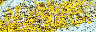
Long Island
Long Island is an island located in the southeast part of the U.S. state of New York, just east of Manhattan. Stretching northeast into the Atlantic Ocean, Long Island contains four counties, two of which are boroughs of New York City , and two of which are mainly suburban...
. Eventually, though, only 45 miles (from Queens
Queens
Queens is the easternmost of the five boroughs of New York City. The largest borough in area and the second-largest in population, it is coextensive with Queens County, an administrative division of New York state, in the United States....
in New York City
New York City
New York is the most populous city in the United States and the center of the New York Metropolitan Area, one of the most populous metropolitan areas in the world. New York exerts a significant impact upon global commerce, finance, media, art, fashion, research, technology, education, and...
to Lake Ronkonkoma, New York
Lake Ronkonkoma, New York
Lake Ronkonkoma is a hamlet in Suffolk County, New York, United States. The population was 19,701 at the 2000 census.Lake Ronkonkoma is located in the town of Brookhaven, but has small sections in the Town of Smithtown....
) were actually constructed, at a cost of $6 million. Construction began in June 1908 (a year after the Bronx River Parkway
Bronx River Parkway
The Bronx River Parkway is a long parkway in downstate New York. It is named for the nearby Bronx River, which it parallels. The southern terminus of the parkway is at Story Avenue near Bruckner Expressway in the Bronx neighborhood of Soundview...
), and a 10-mile-long section of the parkway opened (as far as modern Bethpage) to traffic in October 1908, making it the first superhighway put into use. The Long Island Motor Parkway was a toll road
Toll road
A toll road is a privately or publicly built road for which a driver pays a toll for use. Structures for which tolls are charged include toll bridges and toll tunnels. Non-toll roads are financed using other sources of revenue, most typically fuel tax or general tax funds...
. By 1911, the road was extended to Lake Ronkonkoma
Ronkonkoma Lake
Lake Ronkonkoma, Long Island's largest freshwater lake, is in Suffolk County, New York, and has a circumference of about , and is across on average....
.
The parkway, the first roadway designed exclusively for automobile use, was the first concrete highway built in the United States and it was the first to use overpasses and bridges to eliminate intersections.
Roadway design advances of the 1920s rendered the Motor Parkway obsolete less than 20 years after construction. At the same time Robert Moses
Robert Moses
Robert Moses was the "master builder" of mid-20th century New York City, Long Island, Rockland County, and Westchester County, New York. As the shaper of a modern city, he is sometimes compared to Baron Haussmann of Second Empire Paris, and is one of the most polarizing figures in the history of...
was planning the Northern State Parkway
Northern State Parkway
The Northern State Parkway is a long limited-access state parkway on Long Island in the U.S. state of New York. The western terminus is at the Queens-Nassau County line, where the parkway continues westward into New York City as the Grand Central Parkway...
. Initially the owners and some Long Island officials wanted the Motor Parkway integrated into the state parkway system, despite its narrow roadway and steep bridges not meeting new standards. Robert Moses was against the idea, stating that the parkway would need significant reconstruction. The completion of the Northern State Parkway signaled the end for the Motor Parkway. In 1938 the parkway was sold to New York State for $80,000 in lieu of backtaxes and closed. Most of the Motor Parkway in Queens (west of Winchester Boulevard, whose widening destroyed an overpass) exists as a bicycle trail from Cunningham Park
Cunningham Park
Cunningham Park is a park in the New York City borough of Queens. The park lies between the Grand Central Parkway to the south and the Long Island Expressway, and is bifurcated by the Clearview Expressway...
to Alley Pond Park
Alley Pond Park
Alley Pond Park is the second-largest public park in Queens, New York. It occupies , most of it acquired and cleared by the city in 1929, as authorized by a resolution of the New York City Board of Estimate in 1927. The park is bordered to the east by Douglaston, to the west by Bayside, to the...
, part of the Brooklyn-Queens Greenway
Brooklyn-Queens Greenway
The Brooklyn-Queens Greenway is a bicycling and pedestrian path connecting parks and roads in the New York City boroughs of Brooklyn and Queens, connecting Coney Island in the south to Fort Totten in the north, on Long Island Sound...
.
The Nassau County roadway has been developed, or turned into a right of way for Long Island Power Authority
Long Island Power Authority
The Long Island Power Authority or LIPA [ "lie-pah" ], a municipal subdivision of the State of New York, was created under the Long Island Power Act of 1985 to acquire the Long Island Lighting Company 's assets and securities...
transmission lines. Part of the parkway in Suffolk County exists as Suffolk County Route 67 and parts of the parkway were incorporated into the Meadowbrook State Parkway
Meadowbrook State Parkway
The Meadowbrook State Parkway is a long parkway in Nassau County, New York. The southern terminus is at the Bay Parkway in Jones Beach State Park, where the parkway becomes the Ocean Parkway. The northern terminus is at the Northern State Parkway in Carle Place...
.
Racing
Vanderbilt Cup
The Vanderbilt Cup was the first major trophy in American auto racing.-History:An international event, it was founded by William Kissam Vanderbilt II in 1904 and first held at a course set out in Nassau County on Long Island, New York. The announcement that the race was to be held caused...
races over local roads in Nassau County
Nassau County, New York
Nassau County is a suburban county on Long Island, east of New York City in the U.S. state of New York, within the New York Metropolitan Area. As of the 2010 census, the population was 1,339,532...
during the first decade of the 20th century, but the killing of two spectators and the injury of many others showed the need to eliminate racing on residential streets.
The parkway hosted races on its first open portion in 1908 and on the full road in 1909 and 1910, but another accident in the latter year, killing four with additional injuries, caused the New York Legislature
New York Legislature
The New York State Legislature is the term often used to refer to the two houses that act as the state legislature of the U.S. state of New York. The New York Constitution does not designate an official term for the two houses together...
to ban racing except on race tracks, ending the parkway's career as a racing road.
Access
As an early limited access road, access was only provided at a small number of toll booths, joined to local roads by short connector roads. Traffic could turn left between the parkway and connectors, thus crossing oncoming traffic, so it was not a freeway. The following access points existed: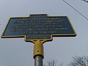
- Nassau BoulevardNew York State Route 25DNew York State Route 25D was a state highway located on Long Island in the U.S. state of New York. It was originally the designation of Horace Harding Boulevard, Nassau Boulevard, and Power House Road, the route of which the Long Island Expressway took over as it was constructed in the 1950s...
(now Long Island Expressway) west of Francis Lewis BoulevardFrancis Lewis BoulevardFrancis Lewis Boulevard is a boulevard in the New York City borough of Queens. The roadway is named for Francis Lewis, a Queens resident who was a signer of the United States Declaration of Independence.-Route description:... - Hillside Avenue - Springfield BoulevardSpringfield BoulevardSpringfield Boulevard is a major north/south roadway that runs through the eastern section of Queens, New York. It goes from Northern Boulevard in Bayside, to 147th Ave in Springfield Gardens. Springfield Boulevard runs through Bayside, Oakland Gardens, Queens Village, Cambria Heights, Laurelton,...
south of 77th Avenue - Great Neck - Lakeville Road south of Lake Road
- Roslyn - Roslyn Road south of Barnyard Lane
- Mineola - Jericho Turnpike at Rudolph Drive
- Garden City - Clinton Road at Vanderbilt Court
- Meadow Brook - Merrick Avenue north of Stewart Avenue
- Massapequa - Hicksville Road (New York State Route 107New York State Route 107New York State Route 107 is a state highway located entirely within Nassau County, New York, in the United States. It runs from Merrick Road in Massapequa to Mill Street and Brewster Avenue in the city of Glen Cove near City Hall...
) south of Avoca Avenue - Bethpage - Round Swamp Road south of Old Bethpage Road
- Huntington - Broad Hollow Road north of Spagnoli Road
- Deer Park - Deer Park Road (New York State Route 231New York State Route 231New York State Route 231 is a north–south state highway located in Suffolk County, New York, in the United States. The route extends for from a partial interchange with NY 27A in Babylon to an interchange with the Northern State Parkway in Dix Hills...
) - East CommackCommack, New YorkCommack is a census-designated place that roughly corresponds to the hamlet by the same name in the towns of Huntington and Smithtown in Suffolk County, New York, United States on Long Island...
- Commack Spur along Harned Road to Jericho Turnpike (New York State Route 25New York State Route 25New York State Route 25 is an east–west state highway in downstate New York in the United States. The route extends for just over from east midtown Manhattan in New York City to the Cross Sound Ferry terminal at Orient Point on the end of Long Island's North Fork...
) - Brentwood - Washington Avenue
- Ronkonkoma - Rosevale Avenue
When the parkway opened, the toll was set at $2. Over the years, the toll declined to $1.50 in 1912, $1 in 1917, and 40c in 1938. The first six toll houses were designed by John Russell Pope
John Russell Pope
John Russell Pope was an architect most known for his designs of the National Archives and Records Administration building , the Jefferson Memorial and the West Building of the National Gallery of Art in Washington, DC.-Biography:Pope was born in New York in 1874, the son of a successful...
, the architect who designed the rotunda in the American Museum of Natural History
American Museum of Natural History
The American Museum of Natural History , located on the Upper West Side of Manhattan in New York City, United States, is one of the largest and most celebrated museums in the world...
and the Jefferson Memorial
Jefferson Memorial
The Thomas Jefferson Memorial is a presidential memorial in Washington, D.C. that is dedicated to Thomas Jefferson, an American Founding Father and the third President of the United States....
. The toll houses were designed to include living space for the toll collectors so that toll could be collected at all hours. One toll house now houses the Garden City Chamber of Commerce in Garden City, Long Island
Garden City, New York
Garden City is a village in the town of Hempstead in central Nassau County, New York, in the United States. It was founded by multi-millionaire Alexander Turney Stewart in 1869, and is located on Long Island, to the east of New York City, from mid-town Manhattan, and just south of the town of...
.
Remaining portions
Suffolk County, New York
Suffolk County is a county located in the U.S. state of New York on the eastern portion of Long Island. As of the 2010 census, the population was 1,493,350. It was named for the county of Suffolk in England, from which its earliest settlers came...
has been obliterated by homes, other roads and structures, or has returned to nature. Some parts can be traced, while some bridges still exist.
The western portion in Queens was reopened a few months after closure as a bicycle path from Cunningham Park
Cunningham Park
Cunningham Park is a park in the New York City borough of Queens. The park lies between the Grand Central Parkway to the south and the Long Island Expressway, and is bifurcated by the Clearview Expressway...
to Alley Pond Park
Alley Pond Park
Alley Pond Park is the second-largest public park in Queens, New York. It occupies , most of it acquired and cleared by the city in 1929, as authorized by a resolution of the New York City Board of Estimate in 1927. The park is bordered to the east by Douglaston, to the west by Bayside, to the...
. This part of the old highway starts at Francis Lewis Boulevard in Cunningham Park near a park connecting Cunningham Park with Kissena Park. There is access to Peck Avenue just after the start of the bike path. It now runs parallel with 199 Street and crosses a bridge over 73 Avenue. It now swings back to Francis Lewis Boulevard, crossing it on a bridge. It continues through the park, crossing the Clearview Expressway on another bridge, and then Hollis Hills Terrace on a fourth bridge before leaving the park. There is now access to 209 and 210 Streets in Hollis Hills. It now goes through a wooded corridor, soon crossing over Bell Boulevard on a bridge, and provides access to 220 Street just east of Bell Boulevard. After crossing Springfield Boulevard on another bridge, there is access to Cloverdale Boulevard. The old highway now enters Alley Pond Park, crosses under the Grand Central Parkway, and provides access to Union Turnpike before ending at Union Turnpike and Winchester Boulevard at the park's boundary.
The highway itself survives as a continuous county road, Vanderbilt Motor Parkway (County Route 67), from Half Hollow Road in Dix Hills to its original end in Ronkonkoma, just a few blocks short of the lake. Signage along the way also identifies it variously as Vanderbilt Parkway and Motor Parkway. From Half Hollow Road, it goes northeast to NYS Route 231, Deer Park Avenue. It starts to parallel the Northern State Parkway and intersects with County Route 4, Commack Road, in Commack. It crosses the Saktigos State Parkway (access northbound only) and heads south to I-495, the Long Island Expressway. It now heads east, parallel with the expressway (there is access to and from the LIE), and then crosses it, heading southeast to NYS Route 111, Joshua's Path. It then heads north, crossing the LIE again at Exit 57, and then curves to the east and crosses NYS Route 454, Veterans Memorial Highway. It heads east, crosses Old Nichols and Terry Roads, and then goes northeast, ending at Rosedale Avenue, County Route 93, in Ronkonkoma, close to the lake.
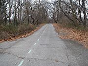
Though not a limited access road since 1938, most of the road was recognizable into the 1970s, while new intersections continued to be cut through it. In the approximate middle of the road in and around Islandia, New York
Islandia, New York
Islandia is a village in Suffolk County, New York, United States. The population was 3,057 at the 2000 census.The Village of Islandia is in the northern part of the Town of Islip.-Overview:...
, office construction and other commercial building has widened the road and made it appear a typical highway. Nonetheless, other portions, especially at the western and eastern ends of the surviving road, can be enjoyed for greenery, graded and banked turns, and rolling hills, albeit at considerably less than racecar speeds.
Preservation
In 2005, two historians / preservationists voiced their intentions of preserving what undeveloped portions of original Long Island Motor Parkway pavement remain for use as part of a historical hike/bike trail (minus the existing Queens trail segment), submitting a formal proposal to Nassau CountyNassau County, New York
Nassau County is a suburban county on Long Island, east of New York City in the U.S. state of New York, within the New York Metropolitan Area. As of the 2010 census, the population was 1,339,532...
, Suffolk County
Suffolk County, New York
Suffolk County is a county located in the U.S. state of New York on the eastern portion of Long Island. As of the 2010 census, the population was 1,493,350. It was named for the county of Suffolk in England, from which its earliest settlers came...
, the Long Island Power Authority
Long Island Power Authority
The Long Island Power Authority or LIPA [ "lie-pah" ], a municipal subdivision of the State of New York, was created under the Long Island Power Act of 1985 to acquire the Long Island Lighting Company 's assets and securities...
(which uses several portions of the old right-of-way to run powerlines) and the State of New York
New York
New York is a state in the Northeastern region of the United States. It is the nation's third most populous state. New York is bordered by New Jersey and Pennsylvania to the south, and by Connecticut, Massachusetts and Vermont to the east...
. Work is expected to begin on the idea at some point in the near future, and most of that work will be carried out by the New York State Department of Transportation
New York State Department of Transportation
The New York State Department of Transportation is responsible for the development and operation of highways, railroads, mass transit systems, ports, waterways and aviation facilities in the U.S...
.
The most prominent remaining toll house can be found in Garden City
Garden City, New York
Garden City is a village in the town of Hempstead in central Nassau County, New York, in the United States. It was founded by multi-millionaire Alexander Turney Stewart in 1869, and is located on Long Island, to the east of New York City, from mid-town Manhattan, and just south of the town of...
.
Once located at the juncture of Clinton Road and Vanderbilt Court, it was moved in 1989 to its current location in the heart of the village at 230 Seventh Street. It now serves as the headquarters of the Garden City Chamber of Commerce.
Anniversaries
In 2008, the Long Island Motor Parkway celebrated its 100th Anniversary. On October 30, 2011, a centennial event marked the 100th Anniversary of the completion of the parkway's Lake Ronkonkoma section. Led by the winner of the 1909 and 1910 Vanderbilt Cup races, a parade of automobiles made prior to 1948 went from Dix Hills to Lake Ronkonkoma.External links
- Long Island Motor Parkway (VanderbiltCupRaces.com)
- Long Island Vanderbilt Parkway (NYCROADS.com)
- Long Island Motor Parkway Preservation Society (Sam Berliner III)
- Long Island Motor Parkway (Arrt's Arrchives)
- "The Age of the Auto: Sportsman William K. Vanderbilt II's cup race paves the way to the future," by Sylvia Adcock (Newsday—Long Island; Our Story)
- Art's Long Island Motor Parkway Site (Art K.)
- LIMP (wikimapia.org map showing route and remnants of the parkway)