
Jarrahdale, Western Australia
Encyclopedia
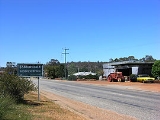
Jarrahdale is a small historic town located 50 km south-east of Perth
, Western Australia
in the Darling Range
. Jarrahdale is a descriptive name, derived from its situation in some of Western Australia's best Jarrah forest. At the 2006 census
, Jarrahdale had a population of 599.
The Jarrahdale Timber Company constructed a railway for the transport of timber from Jarrahdale through Mundijong
to Rockingham
. In 1872 the townsite was granted timber concessions and the town was born, however it was not gazetted until 1913.
The locality was burnt out in an 1895 fire. The current townsite is west of its first location.
Historic buildings in the area consist of: Mill managers house, nurses quarters/hospital, general store, single mans quarters, Gianatti store, Murray Arms/Jarrahdale Tavern/Rileys Bar, churches, Post Office and a number of other locations. A POW camp operating during the WW2 exist outside the town. Recently the old mill office, behind the nurses quarters, was destroyed by fire, a hazard that has destroyed many buildings within the historic precinct in its lifetime.
On the main pass road, Jarrahdale Road, are located the successive mill site locations and to the extremity of the town heading east, the last mill site which still contains relics of its existence. This mill was operated by Bunnings
until 1997 followed the year after by the Jarrahdale Alcoa alumina operations cessation. Bunnings removed the majority of the mills workings as did Alcoa with their site.
After the closure of the towns founding industries, the local Shire of Serpentine-Jarrahdale looked to keep the town relevant, so instigated a redevelopment scheme which is headed by the Jarrahdale Heritage Park which houses the previous mill sites and the last standing mill built in the 1930s. This mill is still operating as a small production business called Heritage Sawmillers, located on the Gooralong Brook which flows through the townsite.
Natural beauty is the areas best feature, with surrounding walks and parks featuring postcards of what the Australian bush had once been. The area contains catchment area and steep slopes which are the habitat of the timber Jarrah. In these conditions the trees grow tall and thrive. It is said virgin remnants of this bushland, of poor quality timber however, still grow near the Kitty's George walk trail within the Serpentine National Park. The Forest Products Commission has announced returns to logging in the Jarrahdale town location, plotting sites east of the townsite in circa 50 year old regrowth.
Numerous mill sites existed in the jarrah forest surrounding Jarrahdale, at least a couple flooded with the damming of the Serpentine river to form the Serpentine dam. Railway formations and cuttings are interesting signposts to a very productive Jarrahdale of the past. "By the 1900s, Jarrahdale had a town population of about 1200 people while 800 more were housed in surrounding bush landings and remote sites." From 1925 until 1927, a portable school was established in a building mounted on railway trucks so that it could be easily transported by forestry train from one work camp to another as timber-getters and their families moved through the forest.
Perth, Western Australia
Perth is the capital and largest city of the Australian state of Western Australia and the fourth most populous city in Australia. The Perth metropolitan area has an estimated population of almost 1,700,000....
, Western Australia
Western Australia
Western Australia is a state of Australia, occupying the entire western third of the Australian continent. It is bounded by the Indian Ocean to the north and west, the Great Australian Bight and Indian Ocean to the south, the Northern Territory to the north-east and South Australia to the south-east...
in the Darling Range
Darling Scarp
The Darling Scarp, also referred to as the Darling Range or Darling Ranges, is a low escarpment running north-south to the east of the Swan Coastal Plain and Perth, Western Australia...
. Jarrahdale is a descriptive name, derived from its situation in some of Western Australia's best Jarrah forest. At the 2006 census
Census in Australia
The Australian census is administered once every five years by the Australian Bureau of Statistics. The most recent census was conducted on 9 August 2011; the next will be conducted in 2016. Prior to the introduction of regular censuses in 1961, they had also been run in 1901, 1911, 1921, 1933,...
, Jarrahdale had a population of 599.
The Jarrahdale Timber Company constructed a railway for the transport of timber from Jarrahdale through Mundijong
Mundijong, Western Australia
Mundijong is an outer suburb of the Western Australian capital city of Perth. Originally named Jarrahdale Junction, it was at the junction of the Rockingham-Jarrahdale line and the government line from Perth to Bunbury which was built in 1893...
to Rockingham
Rockingham, Western Australia
Rockingham is a suburb and primary centre in Western Australia south-west of the Perth city centre and south of Fremantle. It has a beachside location at Mangles Bay, the southern extremity of Cockburn Sound. To its north stretches the maritime and resource-industry installations of Kwinana and...
. In 1872 the townsite was granted timber concessions and the town was born, however it was not gazetted until 1913.
The locality was burnt out in an 1895 fire. The current townsite is west of its first location.
Historic buildings in the area consist of: Mill managers house, nurses quarters/hospital, general store, single mans quarters, Gianatti store, Murray Arms/Jarrahdale Tavern/Rileys Bar, churches, Post Office and a number of other locations. A POW camp operating during the WW2 exist outside the town. Recently the old mill office, behind the nurses quarters, was destroyed by fire, a hazard that has destroyed many buildings within the historic precinct in its lifetime.
On the main pass road, Jarrahdale Road, are located the successive mill site locations and to the extremity of the town heading east, the last mill site which still contains relics of its existence. This mill was operated by Bunnings
Bunnings Warehouse
Bunnings Warehouse is Australia's largest hardware chain with stores in Australia and New Zealand. The chain is owned by Wesfarmers Limited.-History:-Pre 1900s:...
until 1997 followed the year after by the Jarrahdale Alcoa alumina operations cessation. Bunnings removed the majority of the mills workings as did Alcoa with their site.
After the closure of the towns founding industries, the local Shire of Serpentine-Jarrahdale looked to keep the town relevant, so instigated a redevelopment scheme which is headed by the Jarrahdale Heritage Park which houses the previous mill sites and the last standing mill built in the 1930s. This mill is still operating as a small production business called Heritage Sawmillers, located on the Gooralong Brook which flows through the townsite.
Natural beauty is the areas best feature, with surrounding walks and parks featuring postcards of what the Australian bush had once been. The area contains catchment area and steep slopes which are the habitat of the timber Jarrah. In these conditions the trees grow tall and thrive. It is said virgin remnants of this bushland, of poor quality timber however, still grow near the Kitty's George walk trail within the Serpentine National Park. The Forest Products Commission has announced returns to logging in the Jarrahdale town location, plotting sites east of the townsite in circa 50 year old regrowth.
Numerous mill sites existed in the jarrah forest surrounding Jarrahdale, at least a couple flooded with the damming of the Serpentine river to form the Serpentine dam. Railway formations and cuttings are interesting signposts to a very productive Jarrahdale of the past. "By the 1900s, Jarrahdale had a town population of about 1200 people while 800 more were housed in surrounding bush landings and remote sites." From 1925 until 1927, a portable school was established in a building mounted on railway trucks so that it could be easily transported by forestry train from one work camp to another as timber-getters and their families moved through the forest.
See also
- Dwellingup fires of 1961Dwellingup fires of 1961In early 1961, a series of bushfires burned in the southwest of Western Australia. The devastating fires burned large areas of forest in and around Dwellingup from 20 to 24 January, at Pemberton and in the Shannon River region between 11 and 15 February, and in the Augusta-Margaret River area in...
- Mundijong, Western AustraliaMundijong, Western AustraliaMundijong is an outer suburb of the Western Australian capital city of Perth. Originally named Jarrahdale Junction, it was at the junction of the Rockingham-Jarrahdale line and the government line from Perth to Bunbury which was built in 1893...
- South Western HighwaySouth Western HighwaySouth Western Highway is a highway in the South West region of Western Australia connecting Perth's southeast with Walpole. It is a part of the National Highway 1 network for most of its length...