
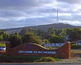
Mount Barker, Western Australia
Encyclopedia
Mount Barker is a town on the Albany Highway
and is the administrative centre of the Shire of Plantagenet in the Great Southern region of Western Australia
. At the 2006 census
, Mount Barker had a population of 1,761.
The town was named after the nearby hill, which it is believed was named by Dr T B Wilson RN
, in honour of Captain Collet Barker
.
and 50 kilometres (31 mi) north of the city of Albany
. The coastal town of Denmark
is around 50 kilometres (31 mi) by road to the south-west via the Denmark Mount Barker Road (locally referred to as "Denbarker Road"). The timber town of Manjimup
is 162 kilometres (101 mi) west of Mount Barker, via Muir's Highway. The Hay River, which flows into Wilson Inlet at Denmark, begins its journey just west of Mount Barker.
, inhabited the area. These were a nomadic people who followed seasonal food supplies. The Aboriginal name for Mount Barker Hill is 'Pwakkenbak'. Dr Wilson was assisted by Aboriginal guide, Mokare
, a Minang man from Albany
, who expressed some discomfort at the proximity of the site to the hostile Wilmen of the interior, in his exploration of the region in 1829. European settlement of the Hay River area commenced around the 1830s and the opening of the Perth/Albany Railway
in 1889 helped ensure the town's future with the first store opening in 1890. Population growth continued through the 1890s and the first school and the town hall were opened in 1893.
The Plantagenet Shire
owns and operates the Great Southern Regional Cattle Saleyards that provides services to cattle producers from within and outside the shire.
 Mount Barker is also home to The Banksia Farm which boasts one of every known species of Banksia
and most species of Dryandra
. There is also a cafe, shop and tours of the Banksia and wildflower gardens.
The Stirling
and Porongurup Range
National Parks are located within the Plantagenet Shire and these, together with the local premium wine industry, have contributed to the growth of tourism in and around Mount Barker.
Available accommodation includes motels, caravan park and a number of bed & breakfasts and farm-stays in the surrounding area.
There has been a steady growth of hobby farming around the town and throughout the shire as people abandon city-life for a 'tree-change'. This has seen a corresponding increase in cottage industries offering a range of art and craft products.
A quarry to the east of the town is one of two major sources of spongolite
, also called 'Mount Barker Stone'. While spongolite is commercially exploited for its absorbent qualities, it is also sometimes locally cut into bricks to use as a building material. A good example of this is the Plantagenet Players theatre in Marmion Street.
In 2011 a windfarm consisting of three wind turbines will be installed to provide power to the town of Mount Barker and surrounding areas.
is easily visible some 50 km away. In the summer months, many locals use the hill lookout to assess any risk posed by nearby fires.
 Mount Barker is also home to numerous historic buildings, such as:
The Stirling Range lies approximately 40 km to the north-east of the town by road, via Kendenup. The Porongurup Range is a 15-minute drive to the east of the town. The two ranges have vastly different appearances and display different flora and geology. Both parks have gazetted walk trails that are especially popular during the spring wildflower season, from August to November.
 Mount Barker has a hospital and medical centre, police station, TAFE College
, a Community college catering for K-12 schooling, childcare facilities plus Scouts
and Girl Guides. The new shire offices were opened in the town centre in 2006.
In 2004 the state government announced preliminary funding for construction of the Mount Barker Community College. This 'One Community, One College' project will ultimately see all public schooling, from kindergarten to TAFE, located on the existing Mount Barker Senior High School site. Work commenced on the project in January 2007 and it is expected that it will cater for years 4 to 12 from 2008 with expansion to continue past that date. It is anticipated that this integrated facility, which pools resources, will act as a model for other regional communities. In December 2007 funding for Stage Two, for Kindergarten to year 3, was confirmed. Construction of all stages is now complete as is the new Trade Training Centre.
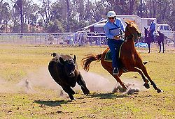
Mount Barker has commercial, retail and industrial facilities associated with the regional centre for the Plantagenet Shire. Sporting facilities include a football ground, a modern, indoor recreation centre and gymnasium, a 50m outdoor swimming pool, speedway track and horse-racing track. Popular sports include Australian Rules Football
, rugby union
, cricket
and equestrian pursuits
.
Besides the public library, Mount Barker also has cultural facilities including a public art gallery that displays and offers works by local artists. There is also a popular amateur theatre
company, "The Plantagenet Players", which has members from nine years old to seniors.
Emergency services in the town consist of Police and volunteers in the St John Ambulance, Fire & Rescue Service, Bush Fire Service and State Emergency Service. Training and equipment is provided by both the Shire and State Government. There are a number of charitable organisations including Rotary, Lions, Red Cross, and Anglicare.
The Great Southern Railway
, which runs through town, commenced operation to Mount Barker in 1889, boosting expansion in the region. There are no longer passenger services on the line which is used primarily for grain haulage to Albany Port.
Pardelup Prison
is located near Denbarker, just west of Mount Barker.
Residents of Mount Barker, Western Australia comment that the town is often confused with Mount Barker, South Australia
, especially when dealing with national telephone centres based outside Western Australia.
Mount Barker also has a new skate park
 Mount Barker has a temperate climate with warm to hot summers and mild to cold winters. While summer temperatures can exceed 40 degrees Celsius, the average is around 26 degrees. Overnight temperatures can drop below zero degrees in winter but daytime winter temperatures average 10-13 degrees Celsius.
Rainfall averages from around 24 millimetre (0.94488188976378 in) per month in January to over 100 millimetres (4 in) in July.
Albany Highway
Albany Highway is a generally northwest-southeast highway in the south of Western Australia which links the state's capital Perth with its oldest settlement, Albany. The highway is approximately in length, is designated State Route 30 and separates Western Australia's Great Southern region from...
and is the administrative centre of the Shire of Plantagenet in the Great Southern region of Western Australia
Western Australia
Western Australia is a state of Australia, occupying the entire western third of the Australian continent. It is bounded by the Indian Ocean to the north and west, the Great Australian Bight and Indian Ocean to the south, the Northern Territory to the north-east and South Australia to the south-east...
. At the 2006 census
Census in Australia
The Australian census is administered once every five years by the Australian Bureau of Statistics. The most recent census was conducted on 9 August 2011; the next will be conducted in 2016. Prior to the introduction of regular censuses in 1961, they had also been run in 1901, 1911, 1921, 1933,...
, Mount Barker had a population of 1,761.
The town was named after the nearby hill, which it is believed was named by Dr T B Wilson RN
Thomas Braidwood Wilson
Thomas Braidwood Wilson FRGS was an Australian surgeon and explorer. He was born in Uphall, West Lothian, Scotland, the son of James, and Catherine Boak.-Sea Voyages:...
, in honour of Captain Collet Barker
Collet Barker
Collet Barker was a British military officer and explorer. He explored areas of South Australia, Western Australia and Cobourg Peninsula, Northern Territory-History:Barker was born in Hackney, he lived in Newbury as a child...
.
Location
Mount Barker is situated on Albany Highway 360 kilometres (224 mi) south of PerthPerth, Western Australia
Perth is the capital and largest city of the Australian state of Western Australia and the fourth most populous city in Australia. The Perth metropolitan area has an estimated population of almost 1,700,000....
and 50 kilometres (31 mi) north of the city of Albany
Albany, Western Australia
Albany is a port city in the Great Southern region of Western Australia, some 418 km SE of Perth, the state capital. As of 2009, Albany's population was estimated at 33,600, making it the 6th-largest city in the state....
. The coastal town of Denmark
Denmark, Western Australia
Denmark is a town in the Great Southern region of Western Australia, south-south-east of the state capital of Perth. At the 2006 census, Denmark had a population of 2,732.-History:...
is around 50 kilometres (31 mi) by road to the south-west via the Denmark Mount Barker Road (locally referred to as "Denbarker Road"). The timber town of Manjimup
Manjimup, Western Australia
Manjimup is a town in Western Australia, south of the state capital, Perth. The town of Manjimup is a regional centre for the largest shire in the South West of Western Australia. At the 2006 census, Manjimup had a population of 4,239.-History:...
is 162 kilometres (101 mi) west of Mount Barker, via Muir's Highway. The Hay River, which flows into Wilson Inlet at Denmark, begins its journey just west of Mount Barker.
History
Prior to European settlement, small groups of Aboriginal people, called the Bibbulmun (a clan of the Noongar) PeopleNoongar
The Noongar are an indigenous Australian people who live in the south-west corner of Western Australia from Geraldton on the west coast to Esperance on the south coast...
, inhabited the area. These were a nomadic people who followed seasonal food supplies. The Aboriginal name for Mount Barker Hill is 'Pwakkenbak'. Dr Wilson was assisted by Aboriginal guide, Mokare
Mokare
Mokare was a Noongar man, an Aboriginal man from the south-west corner of Australia who was pivotal in aiding European exploration of the area. Mokare had two known brothers: Mollian Mokare (c. 1800 - 26 June 1831) was a Noongar man, an Aboriginal man from the south-west corner of Australia who...
, a Minang man from Albany
Albany, Western Australia
Albany is a port city in the Great Southern region of Western Australia, some 418 km SE of Perth, the state capital. As of 2009, Albany's population was estimated at 33,600, making it the 6th-largest city in the state....
, who expressed some discomfort at the proximity of the site to the hostile Wilmen of the interior, in his exploration of the region in 1829. European settlement of the Hay River area commenced around the 1830s and the opening of the Perth/Albany Railway
Great Southern Railway (Western Australia)
The Great Southern Railway was the name of a railway company that operated from Beverley to Albany in Western Australia between 1886 and 1896. In 1896 the Western Australian Government Railways took over this company and the railway route also kept the name.- Construction :The first sods for the...
in 1889 helped ensure the town's future with the first store opening in 1890. Population growth continued through the 1890s and the first school and the town hall were opened in 1893.
Industry
Apple orchards were once one of the major industries in the region and thrived until the mid 1960s. Today, viticulture, wheat, canola, plantation timber, sheep and cattle are some of the main agricultural activities still carried out around Mount Barker.The Plantagenet Shire
Plantagenet, Western Australia
The Shire of Plantagenet is a Local Government Area in the Great Southern region of Western Australia, managed from the town of Mount Barker, south of Perth and north of Albany...
owns and operates the Great Southern Regional Cattle Saleyards that provides services to cattle producers from within and outside the shire.
Banksia
Banksia is a genus of around 170 species in the plant family Proteaceae. These Australian wildflowers and popular garden plants are easily recognised by their characteristic flower spikes and fruiting "cones" and heads. When it comes to size, banksias range from prostrate woody shrubs to trees up...
and most species of Dryandra
Dryandra
Banksia ser. Dryandra is a series of 94 species of shrub to small tree in the plant genus Banksia. It was considered a separate genus named Dryandra until early 2007, when it was merged into Banksia on the basis of extensive molecular and morphological evidence that Banksia was paraphyletic with...
. There is also a cafe, shop and tours of the Banksia and wildflower gardens.
The Stirling
Stirling Range
The Stirling Range or Koikyennuruff is a range of mountains and hills in the Great Southern region of Western Australia, 337 km south-east of Perth. It is located at approximately and is over 60 km wide from west to east, stretching from the highway between Mount Barker and Cranbrook...
and Porongurup Range
Porongurup National Park
Porongurup National Park is a national park in the Great Southern region of Western Australia , 360 km southeast of Perth and 40 km from Albany....
National Parks are located within the Plantagenet Shire and these, together with the local premium wine industry, have contributed to the growth of tourism in and around Mount Barker.
Available accommodation includes motels, caravan park and a number of bed & breakfasts and farm-stays in the surrounding area.
There has been a steady growth of hobby farming around the town and throughout the shire as people abandon city-life for a 'tree-change'. This has seen a corresponding increase in cottage industries offering a range of art and craft products.
A quarry to the east of the town is one of two major sources of spongolite
Spongolite
Spongolite is a stone made almost entirely from fossilised sponges. It is light and porous.The silica spicules fossilised with the sponges makes the material hazardous to handle by being highly abrasive...
, also called 'Mount Barker Stone'. While spongolite is commercially exploited for its absorbent qualities, it is also sometimes locally cut into bricks to use as a building material. A good example of this is the Plantagenet Players theatre in Marmion Street.
In 2011 a windfarm consisting of three wind turbines will be installed to provide power to the town of Mount Barker and surrounding areas.
Wine region
Mount Barker is one of the 5 nominated subregions of the Great Southern wine region in Western Australia, which is Australia's largest wine region with a rectangle 200 kilometres from east to west and over 100 kilometers from north to south. The area has been described as 'the birthplace of the Great Southern wine region' and has won numerous awards for a variety of wines. Situated as it is in the middle of the Great Southern, the continental aspects of the climate make this quintessential country for Riesling and Shiraz. While, as with the rest of the region, rainfall is winter-spring dominant, late vintage rains can create problems. Mount Barker's continentality also means greater diurnal temperature fluctuations and the occasional spring frost. The Plantagenet Plateau, with Mount Barker its centre point, is marked by its marri soils, lateritic gravelly/sandy loams coming directly from granite rock protusions. Lat: 34 36’S; Alt: 180–250 m; Hdd: 1488; Gsr: 287 mm; Mjt: 19C; Harvest: Early March to mid-April; Chief Viticultural Hazard: Spring frosts; late vintage rain. Plantagenet Wines established in 1965 was one of the first wineries in the region and is located within the town boundary.Features
Mount Barker Hill, just 5 km from the town centre, reaches 404 metres above sea level. A sealed road leads to the base of a 168 metre high TV tower - the tallest free-standing tower in the southern hemisphere - on the summit of the hill. There is an aging information sign which states that the steel TV tower weighs 218 tonnes. There is also a lookout and a granite cairn with a bronze directional plate. Views extend north to the Stirling Range and east to the Porongurup Range. An elevated concrete lookout offers views South to Albany and south-west toward Denmark. On a clear day, the Albany Wind FarmAlbany Wind Farm, Western Australia
Albany wind farm is a wind power station near Albany, Western Australia. It has 12 wind turbines, with a generating capacity of 21 MW of electricity. It was commissioned in October 2001.The farm has 12 wind turbine generators situated on site...
is easily visible some 50 km away. In the summer months, many locals use the hill lookout to assess any risk posed by nearby fires.
- The old police station, opened in 1868, is now a museum.
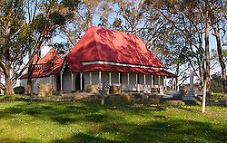
- St WerburghsWerburghWerburh or Wærburh is an English saint and the patron saint of Chester....
Chapel was built in 1872 with walls made from chopped straw and clay and woodwork formed from local jarrah. A small cemetery doubles as a historical reference for the region. The chapel is now a tourist drawcard and still operates a regular service. - The Mount Barker Post Office and Telegraph Station, built in 1892, ceased operation in the 1960s. Today it is named 'Mitchell House' and houses the local art society and gallery.
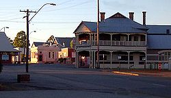
- Plantagenet Hotel was built between 1912 and 1914. The verandah includes apple motifs, in celebration of the flourishing apple industry. The hotel is still open for business.
- The town railway building, built in 1923, was restored in 1997 and today houses the Mount Barker Visitor Centre that offers local tourism information and acts as a booking agency for bus travel from Mount Barker.
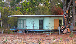
- Sometime from the late 1950s to the early 1960s, Dutch immigrant and engineer Hubertus Johannes Van der Kolk built a circular house at the northern end of Mount Barker, beside Albany Highway. This unique structure, which could be rotated through 180 degrees to exploit seasonal changes, was labelled "The Round House". Though the home has fallen into disrepair, it was heritage listed in 2005 and Heritage Minister Francis Logan said "It was an energy-efficient concept ahead of its time." The home was hidden from passers-by for many years by trees and shrubs but clearing for major roadworks which commenced in December 2006 resulted in it once again being exposed to public view. The Heritage Council has published a detailed history of this "rare" building in a Register of Heritage Places - Assessment Document.
- The farming areas surrounding the town are also rich with old farmhouses, sheds and machinery.
The Stirling Range lies approximately 40 km to the north-east of the town by road, via Kendenup. The Porongurup Range is a 15-minute drive to the east of the town. The two ranges have vastly different appearances and display different flora and geology. Both parks have gazetted walk trails that are especially popular during the spring wildflower season, from August to November.
Facilities
Technical and Further Education
In Australia, training and further education or TAFE institutions provide a wide range of predominantly vocational tertiary education courses, mostly qualifying courses under the National Training System/Australian Qualifications Framework/Australian Quality Training Framework...
, a Community college catering for K-12 schooling, childcare facilities plus Scouts
Scouting
Scouting, also known as the Scout Movement, is a worldwide youth movement with the stated aim of supporting young people in their physical, mental and spiritual development, that they may play constructive roles in society....
and Girl Guides. The new shire offices were opened in the town centre in 2006.
In 2004 the state government announced preliminary funding for construction of the Mount Barker Community College. This 'One Community, One College' project will ultimately see all public schooling, from kindergarten to TAFE, located on the existing Mount Barker Senior High School site. Work commenced on the project in January 2007 and it is expected that it will cater for years 4 to 12 from 2008 with expansion to continue past that date. It is anticipated that this integrated facility, which pools resources, will act as a model for other regional communities. In December 2007 funding for Stage Two, for Kindergarten to year 3, was confirmed. Construction of all stages is now complete as is the new Trade Training Centre.
Mount Barker has commercial, retail and industrial facilities associated with the regional centre for the Plantagenet Shire. Sporting facilities include a football ground, a modern, indoor recreation centre and gymnasium, a 50m outdoor swimming pool, speedway track and horse-racing track. Popular sports include Australian Rules Football
Australian Football League
The Australian Football League is both the governing body and the major professional competition in the sport of Australian rules football...
, rugby union
Rugby union
Rugby union, often simply referred to as rugby, is a full contact team sport which originated in England in the early 19th century. One of the two codes of rugby football, it is based on running with the ball in hand...
, cricket
Cricket
Cricket is a bat-and-ball game played between two teams of 11 players on an oval-shaped field, at the centre of which is a rectangular 22-yard long pitch. One team bats, trying to score as many runs as possible while the other team bowls and fields, trying to dismiss the batsmen and thus limit the...
and equestrian pursuits
Equestrianism
Equestrianism more often known as riding, horseback riding or horse riding refers to the skill of riding, driving, or vaulting with horses...
.
Besides the public library, Mount Barker also has cultural facilities including a public art gallery that displays and offers works by local artists. There is also a popular amateur theatre
Amateur theatre
Amateur theatre is theatre performed by amateur actors. These actors are not typically members of Actors' Equity groups or Actors' Unions as these organizations exist to protect the professional industry and therefore discourage their members from appearing with companies which are not a signatory...
company, "The Plantagenet Players", which has members from nine years old to seniors.
Emergency services in the town consist of Police and volunteers in the St John Ambulance, Fire & Rescue Service, Bush Fire Service and State Emergency Service. Training and equipment is provided by both the Shire and State Government. There are a number of charitable organisations including Rotary, Lions, Red Cross, and Anglicare.
The Great Southern Railway
Great Southern Railway (Western Australia)
The Great Southern Railway was the name of a railway company that operated from Beverley to Albany in Western Australia between 1886 and 1896. In 1896 the Western Australian Government Railways took over this company and the railway route also kept the name.- Construction :The first sods for the...
, which runs through town, commenced operation to Mount Barker in 1889, boosting expansion in the region. There are no longer passenger services on the line which is used primarily for grain haulage to Albany Port.
Pardelup Prison
Pardelup Prison
Pardelup Prison Farm is an Australian minimum security prison located on a mixed-farming operation 27 km west of Mount Barker, Western Australia...
is located near Denbarker, just west of Mount Barker.
Residents of Mount Barker, Western Australia comment that the town is often confused with Mount Barker, South Australia
Mount Barker, South Australia
Mount Barker is an expanding city, home to 10 258 residents that is 33 kilometres up the South Eastern Freeway, east of Adelaide, in South Australia. It is the seat of the District Council of Mount Barker, is the largest town in the Adelaide Hills, and is one of the fastest growing areas in the...
, especially when dealing with national telephone centres based outside Western Australia.
Mount Barker also has a new skate park
Climate
Rainfall averages from around 24 millimetre (0.94488188976378 in) per month in January to over 100 millimetres (4 in) in July.
Significant weather events
- While light snowfalls are not unusual on the peaks of the Porongurup and Stirling Range, it is very unusual for snow to fall to ground level anywhere in Western Australia. However, snow has been recorded in Mount Barker and the Great Southern region. On 28 August 1992, with a maximum temperature of 7.2 degrees Celsius, two falls of snow were recorded. That same year, on 19 November, a light snowfall was recorded just two weeks before summer, this was the latest in the year snow had been recorded in the state.
- In June 2000, the Town Hall in Mount Barker lost its roof as a result of strong wind gusts.
- On 28 December 2000, unusually hot weather and 44 km/h winds contributed to a bushfire that travelled south through the town, destroying two houses plus other buildings and equipment.
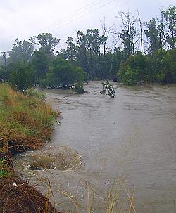
- On 1 April 2005, the Plantagenet Shire suffered substantial flooding after heavy and persistent rainfall in the previous two days.
- Golf ball-sized hail fell in Mount Barker and surrounding districts on 23 October 2006.