
Canning Vale, Western Australia
Encyclopedia
Canning Vale is a large southern suburb of Perth
, and is located 20 km from the Perth CBD
. Its Local Government Area
s are the City of Canning (west of Nicholson Road) and the City of Gosnells (east of Nicholson Road).
, located about 3 km to the suburb's northeast. It was locally known as North Jandakot until 1925.
Until the late 1970s Canning Vale was a farming area consisting of mostly market garden
s and dairy farms due to its swampy terrain with an unusually high abundance of permanent fresh water. Most of the area which is now residential was zoned rural until 1994 on the Metropolitan Region Scheme.
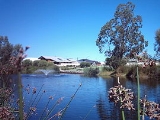
Developers of residential areas have incorporated numerous landscaped lakes into their developments, which serve an important function in draining this swampy area.
to the north and northwest, and Clifton and Acourt Roads to the southwest.
The suburb is split into three distinct regions. North of the rail line near Roe Highway is an industrial area that has a number of major warehousing operations including Market City, a wholesale fresh produce market. Also in the area are many distribution facilities such as the IGA distribution centre. Swan Brewery
, ACI Packaging and BGC
all operate manufacturing plants in the area. South of the line is residential with the normal shopping areas. The western edge of the suburb, contained within a nature reserve, is the Hakea Prison
complex.
The industrial area is within the boundary of the City of Canning as well as a portion of the residential estates (including Livingston and Waratah). The remainder of the residential area and the prison complex are within the boundary of the City of Gosnells.
2001 census, Canning Vale had a mostly middle-income population of 12,849 people living in 4,115 dwellings, all but 205 of which were separate houses. The population is very diverse, with 14% of East or South-East Asian descent and sizable Indian and Italian minorities.
At the ABS 2006 census, Canning Vale had a population of 23,289 which was predominantly Catholic (24.9%), married (62.8%) and with a median household income of $1,591 per week. Canning Vale has 6,331 families of which 62.8% were couple families.
Community facilities include five primary schools - Canning Vale (opened 1994), Ranford (1999), Campbell (2002), Excelsior (2005) and Caledenia (2007) - a private school (St Emilie's Catholic) and a high school, Canning Vale College
, a Sikh temple, community centre and two golf courses (Gosnells Golf Club and Canning Vale Country Club).
Canning Vale has a junior football club, going under the name of Canning Vale Cougars Junior Football Club. No AFL
players have come from the Canning Vale Cougars, but a few WAFL
players have come from Canning Vale. The club celebrated their 10th anniversary in 2006. Canning Vale also has cricket team which is run by the SEMJCC and goes by the name of Canning Vale Junior/Senior Cricket Club.
Season 2011 sees the newly-formed Canning Vale Senior Football Club take to the field for the first time as they participate in the WA Amateur Football League (WAAFL). Their home matches will be played at Clifton Park.
 , which connects with the Kwinana Freeway
(west) and Albany Highway
(east) and provides access to Perth Airport
, while Nicholson Road
 heads north towards Cannington, Western Australia
and Westfield Carousel
, and Ranford Road goes to Armadale
(southeast) and Fremantle
over Kwinana Freeway
via South Street (northwest).
Canning Vale is served by a range of buses linking the area to the Perth CBD
, Murdoch University and to Cannington. Many bus services connect with Transperth trains at Murdoch, Maddington or Thornlie stations. All services are operated by Swan Transit
.
, proposals are being considered which might involve extending the present Transperth rail spur from Thornlie to Canning Vale. This would follow the track of the freight line which bisects Canning Vale, and serve a new station to be built near the Nicholson Road / Garden Street roundabout.
" suburb which leans towards the Liberal Party
in federal and state elections
.
Perth, Western Australia
Perth is the capital and largest city of the Australian state of Western Australia and the fourth most populous city in Australia. The Perth metropolitan area has an estimated population of almost 1,700,000....
, and is located 20 km from the Perth CBD
Central business district
A central business district is the commercial and often geographic heart of a city. In North America this part of a city is commonly referred to as "downtown" or "city center"...
. Its Local Government Area
Local Government Areas of Western Australia
The Australian state of Western Australia is divided into 141 local government areas...
s are the City of Canning (west of Nicholson Road) and the City of Gosnells (east of Nicholson Road).
History
Canning Vale's name derives from the Canning RiverCanning River (Western Australia)
The Canning River is a major tributary of the Swan River in south western Western Australia.-Source and route:With headwaters on the Darling Scarp, the Canning meanders through suburbs of Perth on the Swan Coastal Plain, including Cannington, Thornlie, Riverton, Shelley, Rossmoyne and Mount...
, located about 3 km to the suburb's northeast. It was locally known as North Jandakot until 1925.
Until the late 1970s Canning Vale was a farming area consisting of mostly market garden
Market garden
A market garden is the relatively small-scale production of fruits, vegetables and flowers as cash crops, frequently sold directly to consumers and restaurants. It is distinguishable from other types of farming by the diversity of crops grown on a small area of land, typically, from under one acre ...
s and dairy farms due to its swampy terrain with an unusually high abundance of permanent fresh water. Most of the area which is now residential was zoned rural until 1994 on the Metropolitan Region Scheme.
Developers of residential areas have incorporated numerous landscaped lakes into their developments, which serve an important function in draining this swampy area.
Geography
Canning Vale is bounded by Warton Road to the southeast, Garden Street and Nicholson Road to the northeast, Roe HighwayRoe Highway
Roe Highway is a limited access dual carriageway in Western Australia. It links Great Northern Highway and Middle Swan Road with Kwinana Freeway. It is one of the key heavy vehicle routes in the Perth metropolitan area. Aside from intersections, the speed limit is 100 km/h for most of its length...
to the north and northwest, and Clifton and Acourt Roads to the southwest.
The suburb is split into three distinct regions. North of the rail line near Roe Highway is an industrial area that has a number of major warehousing operations including Market City, a wholesale fresh produce market. Also in the area are many distribution facilities such as the IGA distribution centre. Swan Brewery
Swan Brewery
The Swan Brewery is a brewery located in Perth, Western Australia. It was founded in central Perth in 1837. From 1879, it occupied riverside premises below Mount Eliza, displacing an official "Aboriginal institution" which recognised traditional use of the land by indigenous people.The brewery...
, ACI Packaging and BGC
Buckeridge Group of Companies
Buckeridge Group of Companies, usually abbreviated as BGC, is a consortium of construction and building-related companies operating primarily in Western Australia...
all operate manufacturing plants in the area. South of the line is residential with the normal shopping areas. The western edge of the suburb, contained within a nature reserve, is the Hakea Prison
Hakea Prison
Hakea Prison is an Australian prison located in Canning Vale, Western Australia. The prison officially opened in June 1982 as Canning Vale Prison, managing 248 prisoners. From September 1991, Canning Vale operated as a maximum-security prison until, in 2000, it merged with the CW Campbell Remand...
complex.
The industrial area is within the boundary of the City of Canning as well as a portion of the residential estates (including Livingston and Waratah). The remainder of the residential area and the prison complex are within the boundary of the City of Gosnells.
Demographics
At the ABSAustralian Bureau of Statistics
The Australian Bureau of Statistics is Australia's national statistical agency. It was created as the Commonwealth Bureau of Census and Statistics on 8 December 1905, when the Census and Statistics Act 1905 was given Royal assent. It had its beginnings in section 51 of the Constitution of Australia...
2001 census, Canning Vale had a mostly middle-income population of 12,849 people living in 4,115 dwellings, all but 205 of which were separate houses. The population is very diverse, with 14% of East or South-East Asian descent and sizable Indian and Italian minorities.
At the ABS 2006 census, Canning Vale had a population of 23,289 which was predominantly Catholic (24.9%), married (62.8%) and with a median household income of $1,591 per week. Canning Vale has 6,331 families of which 62.8% were couple families.
Facilities
Canning Vale contains five retail precincts, four within the residential areas. A large industrial area is located in the north-west.Community facilities include five primary schools - Canning Vale (opened 1994), Ranford (1999), Campbell (2002), Excelsior (2005) and Caledenia (2007) - a private school (St Emilie's Catholic) and a high school, Canning Vale College
Canning Vale College
Canning Vale College is a state high school located in Canning Vale, a suburb of Perth, Western Australia.-History:The school opened in 2004. Initial construction cost A$15m for the Business Centre, 2 level Middle School building, Arts Centre and Library. At the end of 2005 work commenced on the...
, a Sikh temple, community centre and two golf courses (Gosnells Golf Club and Canning Vale Country Club).
Canning Vale has a junior football club, going under the name of Canning Vale Cougars Junior Football Club. No AFL
Australian Football League
The Australian Football League is both the governing body and the major professional competition in the sport of Australian rules football...
players have come from the Canning Vale Cougars, but a few WAFL
West Australian Football League
The West Australian Football League is an Australian rules football league based in Perth, Western Australia. The WAFL is the second-most popular in the state, behind the nation-wide Australian Football League...
players have come from Canning Vale. The club celebrated their 10th anniversary in 2006. Canning Vale also has cricket team which is run by the SEMJCC and goes by the name of Canning Vale Junior/Senior Cricket Club.
Season 2011 sees the newly-formed Canning Vale Senior Football Club take to the field for the first time as they participate in the WA Amateur Football League (WAAFL). Their home matches will be played at Clifton Park.
Transport
Canning Vale's northern boundary is the Roe HighwayRoe Highway
Roe Highway is a limited access dual carriageway in Western Australia. It links Great Northern Highway and Middle Swan Road with Kwinana Freeway. It is one of the key heavy vehicle routes in the Perth metropolitan area. Aside from intersections, the speed limit is 100 km/h for most of its length...
Kwinana Freeway
The Kwinana Freeway is a major arterial road in Perth, Western Australia, linking Perth with the southern suburbs and then further on towards Mandurah, a distance of . It has a speed limit of , except in central Perth and south of Lakes Road . Like all Western Australian freeways, the minimum...
(west) and Albany Highway
Albany Highway
Albany Highway is a generally northwest-southeast highway in the south of Western Australia which links the state's capital Perth with its oldest settlement, Albany. The highway is approximately in length, is designated State Route 30 and separates Western Australia's Great Southern region from...
(east) and provides access to Perth Airport
Perth Airport
Perth Airport is an Australian domestic and international airport serving Perth, the capital and largest city of Western Australia. The airport itself is located in the suburb of Perth Airport....
, while Nicholson Road
Nicholson Road, Perth
Nicholson Road is a major north-south road in the southeastern suburbs of Perth, Western Australia, connecting Albany Highway in Cannington with the large residential areas of Thornlie and Canning Vale, before leaving the Perth urban area and terminating in Oakford...
Cannington, Western Australia
Cannington is a southern suburb of Perth, Western Australia. Its Local Government Area is the City of Canning.-History:Cannington's name derives from the Canning River, which forms part of the southwestern boundary of the suburb...
and Westfield Carousel
Westfield Carousel
Westfield Carousel is a major shopping centre, owned by the Westfield Group and located in Cannington, a suburb of Perth. It is located approximately 12 kilometres from Perth on the Albany Highway, and approximately 600 metres from Cannington Train Station...
, and Ranford Road
Armadale, Western Australia
Armadale is a suburb within the City of Armadale, located on the south-eastern edge of Perth's metropolitan area. The major junction of the South Western and Albany Highways, which connect Perth with the South West and Great Southern regions of Western Australia respectively, is located within the...
(southeast) and Fremantle
Fremantle, Western Australia
Fremantle is a city in Western Australia, located at the mouth of the Swan River. Fremantle Harbour serves as the port of Perth, the state capital. Fremantle was the first area settled by the Swan River colonists in 1829...
over Kwinana Freeway
Kwinana Freeway
The Kwinana Freeway is a major arterial road in Perth, Western Australia, linking Perth with the southern suburbs and then further on towards Mandurah, a distance of . It has a speed limit of , except in central Perth and south of Lakes Road . Like all Western Australian freeways, the minimum...
via South Street (northwest).
Canning Vale is served by a range of buses linking the area to the Perth CBD
Central business district
A central business district is the commercial and often geographic heart of a city. In North America this part of a city is commonly referred to as "downtown" or "city center"...
, Murdoch University and to Cannington. Many bus services connect with Transperth trains at Murdoch, Maddington or Thornlie stations. All services are operated by Swan Transit
SWAn transit
Swan Transit is a private bus operator whose primary purpose is to provide commuter bus services in and near the city of Perth, Western Australia. It is part of Transit Systems Australia.-History:...
.
, proposals are being considered which might involve extending the present Transperth rail spur from Thornlie to Canning Vale. This would follow the track of the freight line which bisects Canning Vale, and serve a new station to be built near the Nicholson Road / Garden Street roundabout.
Politics
Canning Vale is a classic "mortgage beltMortgage belt
The Mortgage belt is a term used in Australian politics to signify residential suburbs which have a high concentration of families mortgaging their homes....
" suburb which leans towards the Liberal Party
Liberal Party of Australia
The Liberal Party of Australia is an Australian political party.Founded a year after the 1943 federal election to replace the United Australia Party, the centre-right Liberal Party typically competes with the centre-left Australian Labor Party for political office...
in federal and state elections
Parliament of Western Australia
The Parliament of Western Australia consists of the Legislative Council and the Legislative Assembly . The Parliament sits at Parliament House in Harvest Terrace, Perth....
.