

Nenana River
Encyclopedia
Tanana River
The Tanana River is a tributary of the Yukon River in the U.S. state of Alaska. According to linguist and anthropologist William Bright, the name is from the Koyukon tene no, tenene, literally "trail river"....
, approximately 150 mi (241 km) long, in central Alaska
Alaska
Alaska is the largest state in the United States by area. It is situated in the northwest extremity of the North American continent, with Canada to the east, the Arctic Ocean to the north, and the Pacific Ocean to the west and south, with Russia further west across the Bering Strait...
in the United States
United States
The United States of America is a federal constitutional republic comprising fifty states and a federal district...
. It drains an area on the north slope of the Alaska Range
Alaska Range
The Alaska Range is a relatively narrow, 650-km-long mountain range in the southcentral region of the U.S. state of Alaska, from Lake Clark at its southwest end to the White River in Canada's Yukon Territory in the southeast...
on the south edge of the Tanana Valley
Tanana Valley
The Tanana Valley is a lowland region in central Alaska in the United States, on the north side of the Alaska Range where the Tanana River emerges from the mountains.-Climate:...
southwest of Fairbanks
Fairbanks, Alaska
Fairbanks is a home rule city in and the borough seat of the Fairbanks North Star Borough in the U.S. state of Alaska.Fairbanks is the largest city in the Interior region of Alaska, and second largest in the state behind Anchorage...
.
It issues from the Nenana Glacier in the northern Alaska Range, southwest of Mount Deborah
Mount Deborah
Mount Deborah is a mountain in the U.S. state of Alaska. It is one of the major peaks of the eastern Alaska Range. Despite its low absolute elevation , it is a particularly large and steep peak in terms of its quick rise over local terrain. For example, the Northeast Face rises 7000 feet in...
, approximately 100 mi (160 km) south of Fairbanks. It flows briefly west, then north, forming the eastern boundary of Denali National Park. It emerges from the mountains onto the broad marshy Tanana Valley, joining the Tanana from the south at Nenana, Alaska
Nenana, Alaska
Nenana is a Home Rule City in the Yukon-Koyukuk Census Area of the Unorganized Borough of the U.S. state of Alaska. Nenana lies at the juncture of the Nenana River and the Tanana River. The population was 402 at the 2000 census. "Nenana" means 'a good place to camp between two rivers.'-History...
, approximately 35 mi (56 km) southwest of Fairbanks.
The upper valley of the river furnishes approximately 100 mi (160 km) of the northern route of both the Alaska Railroad
Alaska Railroad
The Alaska Railroad is a Class II railroad which extends from Seward and Whittier, in the south of the state of Alaska, in the United States, to Fairbanks , and beyond to Eielson Air Force Base and Fort Wainwright in the interior of that state...
and the Parks Highway
George Parks Highway
The George Parks Highway , usually called simply the Parks Highway, runs 323 miles from the Glenn Highway 35 miles north of Anchorage to Fairbanks in the Alaska Interior...
(Alaska State Highway 3) connecting Fairbanks and Anchorage
Anchorage, Alaska
Anchorage is a unified home rule municipality in the southcentral part of the U.S. state of Alaska. It is the northernmost major city in the United States...
.
The river was explored in 1885 by Lt. Henry Allen of the United States Army
United States Army
The United States Army is the main branch of the United States Armed Forces responsible for land-based military operations. It is the largest and oldest established branch of the U.S. military, and is one of seven U.S. uniformed services...
. Allen named it the Cantwell River after Lt. John C. Cantwell, of the Revenue-Cutter Service, who had explored the Kobuk River
Kobuk River
The Kobuk River is a river located in the Arctic region of northwestern Alaska in the United States. It is approximately long...
region in 1884 and 1885. In 1898, W. J. Peters and A. H. Brooks of the USGS, reported that the river was called Tutlut by the natives. The Tanana
Tanana
Tanana may refer to:* Tanana, Alaska* Tanana River* Tanana languages* Lower Tanana* Upper Tanana* Tanana * Frank Tanana baseball player...
Indian name was spelled Nenana on a later map.
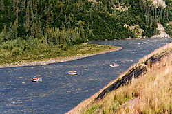
The river is one of the most popular destinations for whitewater rafting in Alaska.
The river contains Alaska blackfish, arctic grayling, arctic lamprey, broad whitefish, burbot, chum salmon, humpback whitefish, king salmon, lake chubs, least cisco, longnose suckers, northern pike, round whitefish, sheefish, silver salmon, and slimy sculpins.
Major archaeological sites located in the valley include Broken Mammoth
Broken Mammoth
Broken Mammoth, Alaska is an archeological site located in the Tanana River Valley, Alaska in the United States. The site was occupied approximately 11,000 B.P. to 12,000 B.P. making this one of the oldest known sites in Alaska. Charles E...
and Swan Point, of late Pleistocene age.
Crossings
| Location | River elevation | Remarks | Coordinates |
|---|---|---|---|
| Mile 216 George Parks Highway George Parks Highway The George Parks Highway , usually called simply the Parks Highway, runs 323 miles from the Glenn Highway 35 miles north of Anchorage to Fairbanks in the Alaska Interior... |
2020 ft | Known unofficially as “Number One Bridge” | 63°27′24"N 148°48′16"W |
| Mile 231.2 George Parks Highway George Parks Highway The George Parks Highway , usually called simply the Parks Highway, runs 323 miles from the Glenn Highway 35 miles north of Anchorage to Fairbanks in the Alaska Interior... |
1800 ft | Crabbie’s Crossing | 63°39′22"N 148°50′11"W |
| Mile 238 George Parks Highway George Parks Highway The George Parks Highway , usually called simply the Parks Highway, runs 323 miles from the Glenn Highway 35 miles north of Anchorage to Fairbanks in the Alaska Interior... |
1580 ft | 0.7 miles north of Denali National Park access road. South extent of “Glitter Gulch” region. | 63°44′14"N 148°53′12"W |
| Mile 242.9 George Parks Highway George Parks Highway The George Parks Highway , usually called simply the Parks Highway, runs 323 miles from the Glenn Highway 35 miles north of Anchorage to Fairbanks in the Alaska Interior... |
1420 ft | Known as “Moody Bridge” or “Windy Bridge”; built 174 ft above river. | 63°48′9"N 148°56′0"W |
| Healy Spur Road | 1280 ft | East of Healy, Alaska Healy, Alaska Healy is a census-designated place in and the borough seat of Denali Borough in the U.S. state of Alaska. The population was 971 at the 2007 census.-Geography:Healy is located at .... and south of Usibelli Coal Mine |
63°51′15"N 148°57′21"W |
| Mile 275.8 George Parks Highway George Parks Highway The George Parks Highway , usually called simply the Parks Highway, runs 323 miles from the Glenn Highway 35 miles north of Anchorage to Fairbanks in the Alaska Interior... |
680 ft | Rex Bridge | 64°13′5"N 149°16′51"W |