

Kodiak Archipelago
Encyclopedia
Archipelago
An archipelago , sometimes called an island group, is a chain or cluster of islands. The word archipelago is derived from the Greek ἄρχι- – arkhi- and πέλαγος – pélagos through the Italian arcipelago...
, or group of island
Island
An island or isle is any piece of sub-continental land that is surrounded by water. Very small islands such as emergent land features on atolls can be called islets, cays or keys. An island in a river or lake may be called an eyot , or holm...
s, south of main land mass of the state of Alaska (United States
United States
The United States of America is a federal constitutional republic comprising fifty states and a federal district...
), about 405 km (251.7 mi) by air south of Anchorage
Anchorage, Alaska
Anchorage is a unified home rule municipality in the southcentral part of the U.S. state of Alaska. It is the northernmost major city in the United States...
in the Gulf of Alaska
Gulf of Alaska
The Gulf of Alaska is an arm of the Pacific Ocean defined by the curve of the southern coast of Alaska, stretching from the Alaska Peninsula and Kodiak Island in the west to the Alexander Archipelago in the east, where Glacier Bay and the Inside Passage are found.The entire shoreline of the Gulf is...
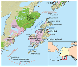
. The largest island in the archipelago is Kodiak Island
Kodiak Island
Kodiak Island is a large island on the south coast of the U.S. state of Alaska, separated from the Alaska mainland by the Shelikof Strait. The largest island in the Kodiak Archipelago, Kodiak Island is the second largest island in the United States and the 80th largest island in the world, with an...
, the second largest island in the United States. The archipelago is about 285 km (177.1 mi) long and 108 km (67.1 mi) across, from the Barren Islands on the north to Chirikof Island
Chirikof Island
Chirikof Island is located in the Gulf of Alaska approximately southwest of Kodiak Island.-Terrain:Chirikof Island consists of of grasses and sedges. Treeless, it lies west of the western tree line in Alaska. The island is shaped like a swim fin with the heel to the north and the webbing to the...
and the Semidi Islands
Semidi Islands
The Semidi Islands are a group of islands of the state of Alaska, USA, lying offshore in the Gulf of Alaska. The islands are part of Kodiak Island Borough and are located southwest of Kodiak Island, about half way between the Alaska Peninsula mainland and Chirikof Island. The largest islands of the...
group on the south. The Archipelago contains 13890 km² (5,363 sq mi) of land. The Kodiak Archipelago contains about 40 small glacier
Glacier
A glacier is a large persistent body of ice that forms where the accumulation of snow exceeds its ablation over many years, often centuries. At least 0.1 km² in area and 50 m thick, but often much larger, a glacier slowly deforms and flows due to stresses induced by its weight...
s, numerous streams and hundreds of species of land and marine animals. Much of its land is forested.
The Kodiak Island Borough
Kodiak Island Borough, Alaska
-National protected areas:* Alaska Maritime National Wildlife Refuge ** Barren Islands** Semidi Wilderness*** Semidi Islands** Trinity Islands*** Sitkinak Island*** Tugidak Island...
contains all of the Kodiak Archipelago and some lands on the mainland. The Kodiak National Wildlife Refuge
Kodiak National Wildlife Refuge
The Kodiak National Wildlife Refuge is a United States National Wildlife Refuge in the Kodiak Archipelago in southwestern Alaska, United States....
encompasses a large percentage of the land in the archipelago.
Islands in the Kodiak Archipelago
- AfognakAfognakAfognak is an island north of Kodiak Island in the U.S. state of Alaska. It is 43 miles from east to west and 23 miles from north to south and has a land area of , making it the 18th largest island in the United States. The coast is split by many long, narrow bays...
- second largest island - Aiaktalik Island
- Ban Island
- Barren Islands - most northerly
- Ushagat Island
- East Amatuli Island
- West Amatuli Island
- Chirikof IslandChirikof IslandChirikof Island is located in the Gulf of Alaska approximately southwest of Kodiak Island.-Terrain:Chirikof Island consists of of grasses and sedges. Treeless, it lies west of the western tree line in Alaska. The island is shaped like a swim fin with the heel to the north and the webbing to the...
- most southernly - Dark Island
- Geese Islands
- Kodiak IslandKodiak IslandKodiak Island is a large island on the south coast of the U.S. state of Alaska, separated from the Alaska mainland by the Shelikof Strait. The largest island in the Kodiak Archipelago, Kodiak Island is the second largest island in the United States and the 80th largest island in the world, with an...
- largest island in the archipelago - Marmot IslandMarmot IslandMarmot Island is an island of the Kodiak Archipelago in the Gulf of Alaska in the state of Alaska, USA. It is part of Kodiak Island Borough and lies east of Afognak Island. The island has a land area of 45.196 km² and is unpopulated....
- most easterly - Near IslandNear Island (Alaska)Near Island is an island that comprises part of the city of Kodiak, Alaska, USA. It lies across the Near Island Channel just south of downtown Kodiak. The island is the site of St. Herman Harbor, the newer of Kodiak's two marinas. Near island has a land area of 1.117 km² and a resident...
- Raspberry IslandRaspberry Island (Alaska)Raspberry Island is an island of the Kodiak Archipelago located in the Gulf of Alaska in the U.S. state of Alaska. It is located two miles northwest of Whale Island, and just across the mile wide Raspberry Strait from the southwestern end of Afognak. The island is separated from Kodiak Island by...
- Semidi IslandsSemidi IslandsThe Semidi Islands are a group of islands of the state of Alaska, USA, lying offshore in the Gulf of Alaska. The islands are part of Kodiak Island Borough and are located southwest of Kodiak Island, about half way between the Alaska Peninsula mainland and Chirikof Island. The largest islands of the...
- most westerly- Aghiyuk Island
- Anowiki Island
- Chowiet Island
- Kateekuk Island
- Kiliktagik Island
- Shuyak IslandShuyak IslandShuyak Island is an island in the northern part of the Kodiak Archipelago in the state of Alaska, USA. It is located just north of Afognak Island, separated from it by the narrow Shuyak Strait. The Stevenson Entrance to Cook Inlet separates it from the Barren Islands further north in the archipelago...
- Sitkalidak IslandSitkalidak IslandSitkalidak Island is an island the western Gulf of Alaska in the Kodiak Island Borough of the state of Alaska, USA. It lies just off the southeast shore of Kodiak Island, across the Sitkalidak Strait from the city of Old Harbor. The island has a land area of 300.839 km² and no resident...
- Spruce IslandSpruce Island (Alaska)Spruce Island is an island in the Kodiak Archipelago of the Gulf of Alaska in the state of Alaska, USA. It lies just off the northeast corner of Kodiak Island, across the Narrow Strait...
- Sundstrom Island
- Trinity IslandsTrinity IslandsOne of the Baffin Island offshore island groups, the uninhabited Trinity Islands are located in Foxe Basin, west of Lonebutte Bay. They are part of the Qikiqtaaluk Region, in the Canadian territory of Nunavut....
- Tugidak IslandTugidak IslandTugidak Island is an island of the Kodiak Archipelago in Kodiak Island Borough, Alaska, United States. It lies southwest of the southern tip of Kodiak Island in the western part of the Gulf of Alaska. Sitkinak Island lies to its east. The two islands are the largest components of the Trinity...
- Sitkinak IslandSitkinak IslandSitkinak Island is an island of the Kodiak Archipelago of the state of Alaska, USA. It lies south of the southern tip of Kodiak Island in the western part of the Gulf of Alaska. Tugidak Island lies to its west. The two islands are the largest components of the Trinity Islands of Alaska...
- Tugidak Island
- Two-Headed Island
- Ugak Island
- Whale IslandWhale Island (Alaska)Whale Island is an island of the Kodiak Archipelago in the Gulf of Alaska in Kodiak Island Borough, Alaska, United States. It lies off the northern end of Kodiak Island, between it and Afognak Island to the north. It is separated from Kodiak Island by Whale Pass, and from Afognak Island by Afognak...
- Woody IslandWoody Island (Alaska)Woody Island is located in Chiniak Bay, east of Kodiak, Alaska. It was originally settled by the native Alutiiq people who called themselves Tangirnarmiut, "the people of Tangirnaq." They inhabited and used Woody Island for thousands of years. The Russians established an agricultural colony on...
The Archaeological Record during the Holocene
"The archaeological record contains several seemingly abrupt changes suggesting population replacements to some, but the current view, followed here, is that there has been long-term cultural continuity." (Ames et al., p.61)The Late Holocene contains four cultural periods: the Early Kachemak, the Late Kachemak, the Koniag, and the Alutiiq. Each period will be broken down by time period, also including the significance of each.
- Early Kachemak (1850 BC - 500 BC) = The period is marked by the shift in mobility patterns: residential foragers to logistical collectors. Dwellings were small in size. Technology and subsistence activities were made more efficient. More efficient ways of processing food were introduced. Material remains include toggling harpoons, netweights, ground slate points, nets, ulus (chopping knife). The Ocean Bay people were the first to inhabit the area. They were considered to be a maritime people, but exploited both marine and terrestrial resources, including mammals and fish. Their only hunting kit included hooks, lines, harpoons, and lances with chipped stone points. By the Middle Holocene, more specialized tool kits were introduced. Originally living in small, dispersed settlements, the small 2-3m tents were replaced by small pit houses around 2000 BC.
- Late Kachemak (500 BC - 1200 AD) = The period is marked by large populations. Logistical patterns of mobility kept increasing, and community sizes increased, having up to ten dwellings. Storage facilities are also introduced. Mortuary practices are considered to be elaborate, and the finding of labrets suggest that social differentiation increased. Craft specialization increased as well.
- Koniag (1200 AD - European Contact) = The period is marked by the population reaching its peak. Houses and settlement sizes continued to increase, giving evidence towards social ranking. Architecture was beginning to be more elaborate and storage features kept increasing in size. Shift in location toward the coast suggests for having better access at marine resources, specifically whales. "There is also evidence of intensified salmon fishing, food production and processing specializations, exchange, and investment in carpentry". (Ames et al., p.62)
- Alutiiq (Modern) = These islands are the original or traditional homes of the Alutiiqu (previously Koniag) peoples. The coastal environment provided excellent productivity for these people, as the terrestrial environment seemed somewhat low or lacked natural resources.