

Abraham Ortelius
Encyclopedia
Abraham Ortelius (April 14, 1527 – June 28,exile in England to take care of Ortelius. Abraham remained close to his cousin Emanuel van Meteren
who would later move to London
. In 1575 he was appointed geographer to the king of Spain, Philip II
, on the recommendation of Arias Montanus, who vouched for his orthodoxy.
He traveled extensively in Europe
. He is specifically known to have traveled throughout the Seventeen Provinces; in southern, western, northern, and eastern Germany (e.g., 1560, 1575–1576); France (1559–1560); England and Ireland
(1576), and Italy
(1578, and perhaps twice or thrice between 1550 and 1558).
Beginning as a map-engraver, in 1547 he entered the Antwerp Guild of Saint Luke
as an illuminator of maps. He supplemented his income trading in books, prints, and maps, and his journeys included yearly visits to the Frankfurt book and print fair where he met Gerardus Mercator
in 1554. In 1560, however, when travelling with Mercator to Trier
, Lorraine
, and Poitiers
, he seems to have been attracted, largely by Mercator’s influence, towards the career of a scientific geographer.

 In 1564 he published his first map, Typus Orbis Terrarum, an eight-leaved wall map of the world. which subsequently appeared in reduced form in the Terrarum
(the only extant copy is in now at Basel University Library
). He also published a two-sheet map of Egypt
in 1565, a plan of the Brittenburg
castle on the coast of the Netherlands
in 1568, an eight-sheet map of Asia
in 1567, and a six-sheet map of Spain before the appearance of his atlas.
In England Ortelius' contacts included William Camden
, Richard Hakluyt
, Thomas Penny
, puritan controversialist William Charke, and Humphrey Llwyd, who would contribute the map of England and Wales
to Ortelius's 1573 edition of the Theatrum.
In 1578 he laid the basis of a critical treatment of ancient geography by his Synonymia geographica (issued by the Plantin press
at Antwerp and republished in expanded form as Thesaurus geographicus in 1587 and again expanded in 1596. In this last edition, Ortelius considers the possibility of continental drift
, a hypothesis proved correct only centuries later).
In 1596 he received a presentation from Antwerp city, similar to that afterwards bestowed on Rubens. His death on June 28, 1598, and burial, in St Michael’s Præmonstratensian Abbey church in Antwerp, were marked by public mourning. Quietis cultor sine lite, uxore, prole, reads the inscription on his tombstone.
editions of this (besides a Dutch
, a French
and a German
edition) appeared before the end of 1572; twenty-five editions came out before Ortelius' death in 1598; and several others were published subsequently, for the atlas continued to be in demand until about 1612. Most of the maps were admittedly reproductions (a list of 87 authors is given in the first Theatrum by Ortelius himself, growing to 183 names in the 1601 Latin edition), and many discrepancies of delineation or nomenclature occur. Errors, of course, abound, both in general conceptions and in detail; thus South America
is initially very faulty in outline, but corrected in the 1587 French
edition, and in Scotland
the Grampians
lie between the Forth
and the Clyde
; but, taken as a whole, this atlas with its accompanying text was a monument of rare erudition and industry. Its immediate precursor and prototype was a collection of thirty-eight maps of European lands, and of Asia
, Africa
, Tartary
and Egypt
, gathered together by the wealth and enterprise, and through the agents, of Ortelius’ friend and patron, Gilles Hooftman, lord of Cleydael and Aertselaer: most of these were printed in Rome
, eight or nine only in the Southern Netherlands.
In 1573 Ortelius published seventeen supplementary maps under the title Additamentum Theatri Orbis Terrarum. Four more Additamenta were to follow, the last one appearing in 1597. He also had a keen interest and formed a fine collection of coin
s, medal
s and antiques
, and this resulted in the book (also in 1573, published by Philippe Galle of Antwerp) Deorum dearumque capita ... ex Museo Ortelii (reprinted in 1582, 1602, 1612, 1680, 1683 and finally in 1699 by Gronovius, Thesaurus Graecarum Antiquitatum. vol. vii).
The Theatrum Orbis Terrarum inspired a six volume work entitled Civitates orbis terrarum edited by Georg Braun
and illustrated by Frans Hogenberg with the assistance of Ortelius himself.
 In 1579 Ortelius brought out his Nomenclator Ptolemaicus and started his Parergon (a series of maps illustrating ancient history, sacred
and secular). He also published Itinerarium per nonnuilas Galliae Belgicae partes (at the Plantin press in 1584, and reprinted in 1630, 1661 in Hegenitius, Itin. Frisio-Hoil., in 1667 by Verbiest, and finally in 1757 in Leuven), a record of a journey in Belgium
and the Rhineland
made in 1575. In 1589 he published Maris Pacifici
, the first dedicated map of the Pacific to be printed. Among his last works were an edition of Caesar (C. I. Caesaris omnia quae extant, Leiden, Raphelingen, 1593), and the Aurei saeculi imago, sive Germanorum veterum vita, mores, ritus et religio. (Philippe Galle, Antwerp, 1596). He also aided Welser in his edition of the Peutinger Table in 1598.
which is of four world maps. This puzzle is made by Ravensburger
, measures 6 feet (1.8 m) × 9 feet (2.7 m), and has over 18,000 pieces.
as an explanation. Kious described Ortelius' thoughts in this way:
The continental drift
theory was generally accepted in geosciences only during the second half of the 20th century, after the hypotheses of Alfred Wegener
had been supported through the discovery of a mechanism for continental drift, and an adequate energy source, in the convection currents of the plastic, very weak upper mantle, or asthenosphere.
Emanuel van Meteren
Emanuel van Meteren or Meteeren was a Flemish historian and Consul for "the Traders of the Low Countries" in London...
who would later move to London
London
London is the capital city of :England and the :United Kingdom, the largest metropolitan area in the United Kingdom, and the largest urban zone in the European Union by most measures. Located on the River Thames, London has been a major settlement for two millennia, its history going back to its...
. In 1575 he was appointed geographer to the king of Spain, Philip II
Philip II of Spain
Philip II was King of Spain, Portugal, Naples, Sicily, and, while married to Mary I, King of England and Ireland. He was lord of the Seventeen Provinces from 1556 until 1581, holding various titles for the individual territories such as duke or count....
, on the recommendation of Arias Montanus, who vouched for his orthodoxy.
He traveled extensively in Europe
Europe
Europe is, by convention, one of the world's seven continents. Comprising the westernmost peninsula of Eurasia, Europe is generally 'divided' from Asia to its east by the watershed divides of the Ural and Caucasus Mountains, the Ural River, the Caspian and Black Seas, and the waterways connecting...
. He is specifically known to have traveled throughout the Seventeen Provinces; in southern, western, northern, and eastern Germany (e.g., 1560, 1575–1576); France (1559–1560); England and Ireland
Ireland
Ireland is an island to the northwest of continental Europe. It is the third-largest island in Europe and the twentieth-largest island on Earth...
(1576), and Italy
Italy
Italy , officially the Italian Republic languages]] under the European Charter for Regional or Minority Languages. In each of these, Italy's official name is as follows:;;;;;;;;), is a unitary parliamentary republic in South-Central Europe. To the north it borders France, Switzerland, Austria and...
(1578, and perhaps twice or thrice between 1550 and 1558).
Beginning as a map-engraver, in 1547 he entered the Antwerp Guild of Saint Luke
Guild of Saint Luke
The Guild of Saint Luke was the most common name for a city guild for painters and other artists in early modern Europe, especially in the Low Countries. They were named in honor of the Evangelist Luke, the patron saint of artists, who was identified by John of Damascus as having painted the...
as an illuminator of maps. He supplemented his income trading in books, prints, and maps, and his journeys included yearly visits to the Frankfurt book and print fair where he met Gerardus Mercator
Gerardus Mercator
thumb|right|200px|Gerardus MercatorGerardus Mercator was a cartographer, born in Rupelmonde in the Hapsburg County of Flanders, part of the Holy Roman Empire. He is remembered for the Mercator projection world map, which is named after him...
in 1554. In 1560, however, when travelling with Mercator to Trier
Trier
Trier, historically called in English Treves is a city in Germany on the banks of the Moselle. It is the oldest city in Germany, founded in or before 16 BC....
, Lorraine
Lorraine (province)
The Duchy of Upper Lorraine was an historical duchy roughly corresponding with the present-day northeastern Lorraine region of France, including parts of modern Luxembourg and Germany. The main cities were Metz, Verdun, and the historic capital Nancy....
, and Poitiers
Poitiers
Poitiers is a city on the Clain river in west central France. It is a commune and the capital of the Vienne department and of the Poitou-Charentes region. The centre is picturesque and its streets are interesting for predominant remains of historical architecture, especially from the Romanesque...
, he seems to have been attracted, largely by Mercator’s influence, towards the career of a scientific geographer.
Map Publisher
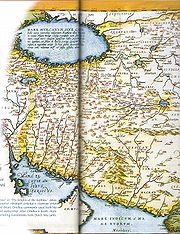
Theatrum Orbis Terrarum
Theatrum Orbis Terrarum is considered to be the first true modern atlas. Written by Abraham Ortelius and originally printed on May 20, 1570, in Antwerp, it consisted of a collection of uniform map sheets and sustaining text bound to form a book for which copper printing plates were specifically...
(the only extant copy is in now at Basel University Library
Basel University Library
The University Library of Basle is one of the biggest libraries in Switzerland. It is located at the University of Basel, at 18 – 20 Schönbeinstrasse. It is also Kantonsbibliothek of Basel-City....
). He also published a two-sheet map of Egypt
Egypt
Egypt , officially the Arab Republic of Egypt, Arabic: , is a country mainly in North Africa, with the Sinai Peninsula forming a land bridge in Southwest Asia. Egypt is thus a transcontinental country, and a major power in Africa, the Mediterranean Basin, the Middle East and the Muslim world...
in 1565, a plan of the Brittenburg
Brittenburg
The Brittenburg, or Lugdunum Batavorum, is a Roman ruin west of Leiden that was visible on the beach between Katwijk aan Zee and Noordwijk aan Zee after storms in the years of 1520, 1552 and 1562...
castle on the coast of the Netherlands
Netherlands
The Netherlands is a constituent country of the Kingdom of the Netherlands, located mainly in North-West Europe and with several islands in the Caribbean. Mainland Netherlands borders the North Sea to the north and west, Belgium to the south, and Germany to the east, and shares maritime borders...
in 1568, an eight-sheet map of Asia
Asia
Asia is the world's largest and most populous continent, located primarily in the eastern and northern hemispheres. It covers 8.7% of the Earth's total surface area and with approximately 3.879 billion people, it hosts 60% of the world's current human population...
in 1567, and a six-sheet map of Spain before the appearance of his atlas.
In England Ortelius' contacts included William Camden
William Camden
William Camden was an English antiquarian, historian, topographer, and officer of arms. He wrote the first chorographical survey of the islands of Great Britain and Ireland and the first detailed historical account of the reign of Elizabeth I of England.- Early years :Camden was born in London...
, Richard Hakluyt
Richard Hakluyt
Richard Hakluyt was an English writer. He is principally remembered for his efforts in promoting and supporting the settlement of North America by the English through his works, notably Divers Voyages Touching the Discoverie of America and The Principal Navigations, Voiages, Traffiques and...
, Thomas Penny
Thomas Penny
Thomas Penny was an English physician and early entomologist. His solo works have not survived and he is primarily known through quotations from other sixteenth century biologists. It is believed that he broke with Aristotle on classification of caterpillars. He was also a Puritan and as such kept...
, puritan controversialist William Charke, and Humphrey Llwyd, who would contribute the map of England and Wales
England and Wales
England and Wales is a jurisdiction within the United Kingdom. It consists of England and Wales, two of the four countries of the United Kingdom...
to Ortelius's 1573 edition of the Theatrum.
In 1578 he laid the basis of a critical treatment of ancient geography by his Synonymia geographica (issued by the Plantin press
Plantin Press
The Plantin Press at Antwerp was one of the focal centers of the fine printed book in the 16th century.Christophe Plantin of Touraine, trained as a bookbinder, fled from Paris, where at least one printer had recently been burned at the stake for heresy, for Antwerp, where he bound books, became a...
at Antwerp and republished in expanded form as Thesaurus geographicus in 1587 and again expanded in 1596. In this last edition, Ortelius considers the possibility of continental drift
Continental drift
Continental drift is the movement of the Earth's continents relative to each other. The hypothesis that continents 'drift' was first put forward by Abraham Ortelius in 1596 and was fully developed by Alfred Wegener in 1912...
, a hypothesis proved correct only centuries later).
In 1596 he received a presentation from Antwerp city, similar to that afterwards bestowed on Rubens. His death on June 28, 1598, and burial, in St Michael’s Præmonstratensian Abbey church in Antwerp, were marked by public mourning. Quietis cultor sine lite, uxore, prole, reads the inscription on his tombstone.
Theatrum Orbis Terrarum
On May 20, 1570, Gilles Coppens de Diest at Antwerp issued Ortelius’ Theatrum Orbis Terrarum, the "first modern atlas" (of 53 maps). Three LatinLatin
Latin is an Italic language originally spoken in Latium and Ancient Rome. It, along with most European languages, is a descendant of the ancient Proto-Indo-European language. Although it is considered a dead language, a number of scholars and members of the Christian clergy speak it fluently, and...
editions of this (besides a Dutch
Dutch language
Dutch is a West Germanic language and the native language of the majority of the population of the Netherlands, Belgium, and Suriname, the three member states of the Dutch Language Union. Most speakers live in the European Union, where it is a first language for about 23 million and a second...
, a French
French language
French is a Romance language spoken as a first language in France, the Romandy region in Switzerland, Wallonia and Brussels in Belgium, Monaco, the regions of Quebec and Acadia in Canada, and by various communities elsewhere. Second-language speakers of French are distributed throughout many parts...
and a German
German language
German is a West Germanic language, related to and classified alongside English and Dutch. With an estimated 90 – 98 million native speakers, German is one of the world's major languages and is the most widely-spoken first language in the European Union....
edition) appeared before the end of 1572; twenty-five editions came out before Ortelius' death in 1598; and several others were published subsequently, for the atlas continued to be in demand until about 1612. Most of the maps were admittedly reproductions (a list of 87 authors is given in the first Theatrum by Ortelius himself, growing to 183 names in the 1601 Latin edition), and many discrepancies of delineation or nomenclature occur. Errors, of course, abound, both in general conceptions and in detail; thus South America
South America
South America is a continent situated in the Western Hemisphere, mostly in the Southern Hemisphere, with a relatively small portion in the Northern Hemisphere. The continent is also considered a subcontinent of the Americas. It is bordered on the west by the Pacific Ocean and on the north and east...
is initially very faulty in outline, but corrected in the 1587 French
French language
French is a Romance language spoken as a first language in France, the Romandy region in Switzerland, Wallonia and Brussels in Belgium, Monaco, the regions of Quebec and Acadia in Canada, and by various communities elsewhere. Second-language speakers of French are distributed throughout many parts...
edition, and in Scotland
Scotland
Scotland is a country that is part of the United Kingdom. Occupying the northern third of the island of Great Britain, it shares a border with England to the south and is bounded by the North Sea to the east, the Atlantic Ocean to the north and west, and the North Channel and Irish Sea to the...
the Grampians
Grampian Mountains (Scotland)
The Grampian Mountains or Grampians are one of the three major mountain ranges in Scotland, occupying a considerable portion of the Scottish Highlands in northeast Scotland.-Extent:...
lie between the Forth
Firth of Forth
The Firth of Forth is the estuary or firth of Scotland's River Forth, where it flows into the North Sea, between Fife to the north, and West Lothian, the City of Edinburgh and East Lothian to the south...
and the Clyde
Firth of Clyde
The Firth of Clyde forms a large area of coastal water, sheltered from the Atlantic Ocean by the Kintyre peninsula which encloses the outer firth in Argyll and Ayrshire, Scotland. The Kilbrannan Sound is a large arm of the Firth of Clyde, separating the Kintyre Peninsula from the Isle of Arran.At...
; but, taken as a whole, this atlas with its accompanying text was a monument of rare erudition and industry. Its immediate precursor and prototype was a collection of thirty-eight maps of European lands, and of Asia
Asia
Asia is the world's largest and most populous continent, located primarily in the eastern and northern hemispheres. It covers 8.7% of the Earth's total surface area and with approximately 3.879 billion people, it hosts 60% of the world's current human population...
, Africa
Africa
Africa is the world's second largest and second most populous continent, after Asia. At about 30.2 million km² including adjacent islands, it covers 6% of the Earth's total surface area and 20.4% of the total land area...
, Tartary
Tartary
Tartary or Great Tartary was a name used by Europeans from the Middle Ages until the twentieth century to designate the Great Steppe, that is the great tract of northern and central Asia stretching from the Caspian Sea and the Ural Mountains to the Pacific Ocean inhabited mostly by Turkic, Mongol...
and Egypt
Egypt
Egypt , officially the Arab Republic of Egypt, Arabic: , is a country mainly in North Africa, with the Sinai Peninsula forming a land bridge in Southwest Asia. Egypt is thus a transcontinental country, and a major power in Africa, the Mediterranean Basin, the Middle East and the Muslim world...
, gathered together by the wealth and enterprise, and through the agents, of Ortelius’ friend and patron, Gilles Hooftman, lord of Cleydael and Aertselaer: most of these were printed in Rome
Rome
Rome is the capital of Italy and the country's largest and most populated city and comune, with over 2.7 million residents in . The city is located in the central-western portion of the Italian Peninsula, on the Tiber River within the Lazio region of Italy.Rome's history spans two and a half...
, eight or nine only in the Southern Netherlands.
In 1573 Ortelius published seventeen supplementary maps under the title Additamentum Theatri Orbis Terrarum. Four more Additamenta were to follow, the last one appearing in 1597. He also had a keen interest and formed a fine collection of coin
Coin
A coin is a piece of hard material that is standardized in weight, is produced in large quantities in order to facilitate trade, and primarily can be used as a legal tender token for commerce in the designated country, region, or territory....
s, medal
Medal
A medal, or medallion, is generally a circular object that has been sculpted, molded, cast, struck, stamped, or some way rendered with an insignia, portrait, or other artistic rendering. A medal may be awarded to a person or organization as a form of recognition for athletic, military, scientific,...
s and antiques
Antiques
An antique is an old collectible item. It is collected or desirable because of its age , beauty, rarity, condition, utility, personal emotional connection, and/or other unique features...
, and this resulted in the book (also in 1573, published by Philippe Galle of Antwerp) Deorum dearumque capita ... ex Museo Ortelii (reprinted in 1582, 1602, 1612, 1680, 1683 and finally in 1699 by Gronovius, Thesaurus Graecarum Antiquitatum. vol. vii).
The Theatrum Orbis Terrarum inspired a six volume work entitled Civitates orbis terrarum edited by Georg Braun
Georg Braun
Georg Braun was a topo-geographer. From 1572 to 1617 he edited the Civitates orbis terrarum, which contains 546 prospects, bird's-eye views, and maps of cities from all around the world....
and illustrated by Frans Hogenberg with the assistance of Ortelius himself.
Later maps
Sacred
Holiness, or sanctity, is in general the state of being holy or sacred...
and secular). He also published Itinerarium per nonnuilas Galliae Belgicae partes (at the Plantin press in 1584, and reprinted in 1630, 1661 in Hegenitius, Itin. Frisio-Hoil., in 1667 by Verbiest, and finally in 1757 in Leuven), a record of a journey in Belgium
Belgium
Belgium , officially the Kingdom of Belgium, is a federal state in Western Europe. It is a founding member of the European Union and hosts the EU's headquarters, and those of several other major international organisations such as NATO.Belgium is also a member of, or affiliated to, many...
and the Rhineland
Rhineland
Historically, the Rhinelands refers to a loosely-defined region embracing the land on either bank of the River Rhine in central Europe....
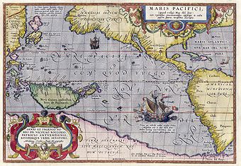
made in 1575. In 1589 he published Maris Pacifici
Maris Pacifici
Maris Pacifici is more accurately named the Descriptio Maris Pacifici, Description of the Pacific Sea. It was the first dedicated map of the Pacific to be printed and is considered an important advancement in cartography....
, the first dedicated map of the Pacific to be printed. Among his last works were an edition of Caesar (C. I. Caesaris omnia quae extant, Leiden, Raphelingen, 1593), and the Aurei saeculi imago, sive Germanorum veterum vita, mores, ritus et religio. (Philippe Galle, Antwerp, 1596). He also aided Welser in his edition of the Peutinger Table in 1598.
Modern use of maps
Originals of Ortelius' maps are popular collector's items and often sell for tens of thousands of dollars. Facsimiles of his maps are also available from many retailers. A map he made of North and South America is also included in the world's largest commercially available jigsaw puzzleJigsaw puzzle
A jigsaw puzzle is a tiling puzzle that requires the assembly of numerous small, often oddly shaped, interlocking and tessellating pieces.Each piece usually has a small part of a picture on it; when complete, a jigsaw puzzle produces a complete picture...
which is of four world maps. This puzzle is made by Ravensburger
Ravensburger
Ravensburger Spieleverlag GmbH is a German game company. It is a leader in the European puzzle market.-History:The company was founded by Otto Robert Maier with seat in Ravensburg, a town in Upper Swabia in southern Germany. He began publishing in 1883 with his first author contract...
, measures 6 feet (1.8 m) × 9 feet (2.7 m), and has over 18,000 pieces.
Imagining continental drift
Ortelius was the first to underline the geometrical coincidence between the coasts of America and Europe-Africa, and to propose continental driftContinental drift
Continental drift is the movement of the Earth's continents relative to each other. The hypothesis that continents 'drift' was first put forward by Abraham Ortelius in 1596 and was fully developed by Alfred Wegener in 1912...
as an explanation. Kious described Ortelius' thoughts in this way:
The continental drift
Continental drift
Continental drift is the movement of the Earth's continents relative to each other. The hypothesis that continents 'drift' was first put forward by Abraham Ortelius in 1596 and was fully developed by Alfred Wegener in 1912...
theory was generally accepted in geosciences only during the second half of the 20th century, after the hypotheses of Alfred Wegener
Alfred Wegener
Alfred Lothar Wegener was a German scientist, geophysicist, and meteorologist.He is most notable for his theory of continental drift , proposed in 1912, which hypothesized that the continents were slowly drifting around the Earth...
had been supported through the discovery of a mechanism for continental drift, and an adequate energy source, in the convection currents of the plastic, very weak upper mantle, or asthenosphere.
Еditions
- Abraham Ortelius, Theatrum Orbis Terrarum. Gedruckt zu Nuermberg durch Johann Koler Anno MDLXXII. Mit einer Einführung und Erläuterungen von Ute Schneider. 2., unveränd. Aufl. (Darmstadt, Wissenschaftliche Buchgesellschaft, 2007).