
.gif)
Grampian Mountains (Scotland)
Encyclopedia
_named_(hr).png)
Mountain
Image:Himalaya_annotated.jpg|thumb|right|The Himalayan mountain range with Mount Everestrect 58 14 160 49 Chomo Lonzorect 200 28 335 52 Makalurect 378 24 566 45 Mount Everestrect 188 581 920 656 Tibetan Plateaurect 250 406 340 427 Rong River...
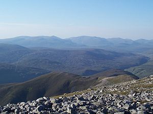
ranges in Scotland
Scotland
Scotland is a country that is part of the United Kingdom. Occupying the northern third of the island of Great Britain, it shares a border with England to the south and is bounded by the North Sea to the east, the Atlantic Ocean to the north and west, and the North Channel and Irish Sea to the...
, occupying a considerable portion of the Scottish Highlands
Scottish Highlands
The Highlands is an historic region of Scotland. The area is sometimes referred to as the "Scottish Highlands". It was culturally distinguishable from the Lowlands from the later Middle Ages into the modern period, when Lowland Scots replaced Scottish Gaelic throughout most of the Lowlands...
in northeast Scotland.
Extent
There is probably more confusion about the extent of The Grampians than any other mountain range in Scotland. The reasons for this can be partially explained by the fact that the name Grampian was used by the local independent television station Grampian Television, as well as being used to designate a large area of the north-east of Scotland following the Regionalisation of Scotland in 1975Local Government (Scotland) Act 1973
The Local Government Act 1973 is an Act of the Parliament of the United Kingdom, that reformed local government in Scotland, on May 16, 1975....
. Largely for those reasons – at least in the minds of people from outside the area – the name of the mountain-range has become synonymous with the area served by Grampian Television, and that administered by the former Grampian Region.
Map makers too - being outsiders - have often added to this confusion by stretching the name across large sections of eastern Scotland. Local writers however, such as Wyness (1968) and Watson (1975) – for example, suffer no such confusion. In the introduction of Wyness (1968) the author, writing about Deeside, puts the northern-edge of the Grampians at the River Dee when he writes:
Clearly, then, Wyness defines the Cairngorm as being the range of mountains running from immediately south of Aberdeen’ westward to Beinn Dearg in the Forest of Atholl.
In Watson (1975) the author – while defining the extent of the Cairngorms
Cairngorms
The Cairngorms are a mountain range in the eastern Highlands of Scotland closely associated with the mountain of the same name - Cairn Gorm.-Name:...
– specifically excludes the range south of the River Dee, writing:
This is clearly poorly researched by Watson and anyone local or familiar with Aberdeen know the hills on the southern outskirts of the town (now a country park) as 'the Gramps', a clear contraction of Grampians.
Both Wyness and Watson roughly agree where the eastern, northern, and western limits of The Cairngorms lie.
The Grampians extend southwest to northeast between the Highland Boundary Fault
Highland Boundary Fault
The Highland Boundary Fault is a geological fault that traverses Scotland from Arran and Helensburgh on the west coast to Stonehaven in the east...
and Gleann Mòr (the Great Glen
Great Glen
The Great Glen , also known as Glen Albyn or Glen More is a series of glens in Scotland running 100 kilometres from Inverness on the Moray Firth, to Fort William at the head of Loch Linnhe.The Great Glen follows a large geological fault known as the Great Glen Fault...
), occupying almost half of the land-area of Scotland. This includes the Cairngorms
Cairngorms
The Cairngorms are a mountain range in the eastern Highlands of Scotland closely associated with the mountain of the same name - Cairn Gorm.-Name:...
and the Lochaber
Lochaber
District of Lochaber 1975 to 1996Highland council area shown as one of the council areas of ScotlandLochaber is one of the 16 ward management areas of the Highland Council of Scotland and one of eight former local government districts of the two-tier Highland region...
hills. The range includes Ben Nevis
Ben Nevis
Ben Nevis is the highest mountain in the British Isles. It is located at the western end of the Grampian Mountains in the Lochaber area of the Scottish Highlands, close to the town of Fort William....
(the highest point in the British Isles at 1,344 metres above sea level) and Ben Macdui
Ben Macdhui (Scotland)
Ben Macdui is the second highest mountain in the United Kingdom after Ben Nevis, and the highest in the Cairngorms. After the defeat of Domnall mac Uilliam in 1187, Donnchad II, Earl of Fife, acquired Strathavon, territory stretching from Ballindalloch to Ben Macdui; because the mountain marked...
(the second highest at 1,309 metres).
The mountains are composed of granite
Granite
Granite is a common and widely occurring type of intrusive, felsic, igneous rock. Granite usually has a medium- to coarse-grained texture. Occasionally some individual crystals are larger than the groundmass, in which case the texture is known as porphyritic. A granitic rock with a porphyritic...
, gneiss
Gneiss
Gneiss is a common and widely distributed type of rock formed by high-grade regional metamorphic processes from pre-existing formations that were originally either igneous or sedimentary rocks.-Etymology:...
, marble
Marble
Marble is a metamorphic rock composed of recrystallized carbonate minerals, most commonly calcite or dolomite.Geologists use the term "marble" to refer to metamorphosed limestone; however stonemasons use the term more broadly to encompass unmetamorphosed limestone.Marble is commonly used for...
, schist
Schist
The schists constitute a group of medium-grade metamorphic rocks, chiefly notable for the preponderance of lamellar minerals such as micas, chlorite, talc, hornblende, graphite, and others. Quartz often occurs in drawn-out grains to such an extent that a particular form called quartz schist is...
s and quartzite
Quartzite
Quartzite is a hard metamorphic rock which was originally sandstone. Sandstone is converted into quartzite through heating and pressure usually related to tectonic compression within orogenic belts. Pure quartzite is usually white to gray, though quartzites often occur in various shades of pink...
. The other major mountain ranges in Scotland are the Northwest Highlands
Northwest Highlands
The Northwest Highlands are the northern third of Scotland that is separated from the Grampian Mountains by the Great Glen . The region comprises , Assynt, Caithness and Sutherland. The Caledonian Canal, which extends from Loch Linnhe in the west, via Loch Ness to the Moray Firth in the north...
and the Southern Uplands
Southern Uplands
The Southern Uplands are the southernmost and least populous of mainland Scotland's three major geographic areas . The term is used both to describe the geographical region and to collectively denote the various ranges of hills within this region...
.
A number of rivers and streams rise in the Grampians: the Tay
River Tay
The River Tay is the longest river in Scotland and the seventh-longest in the United Kingdom. The Tay originates in western Scotland on the slopes of Ben Lui , then flows easterly across the Highlands, through Loch Dochhart, Loch Lubhair and Loch Tay, then continues east through Strathtay , in...
, Spey
River Spey
The River Spey is a river in the northeast of Scotland, the second longest and the fastest-flowing river in Scotland...
, Cowie Water
Cowie Water
The Cowie Water is a river rising in the Grampian Mountains in Aberdeenshire, Scotland that discharges to the North Sea in the northern part of Stonehaven. south of the ruined Cowie Castle...
, Burn of Muchalls
Burn of Muchalls
The Burn of Muchalls is an easterly flowing stream in Aberdeenshire, Scotland that discharges to the North Sea. Its point of discharge is on a rocky beach set with scenic sea stacks...
, Burn of Pheppie
Burn of Pheppie
The Burn of Pheppie is an easterly flowing coastal stream in Aberdeenshire, Scotland that discharges to the North Sea immediately north of the village of Muchalls. Draining chiefly agricultural lands, this stream has a notable lack of turbidity and a pH level of approximately 8.02...
, Burn of Elsick
Burn of Elsick
The Burn of Elsick is a coastal stream in Aberdeenshire, Scotland that discharges to the North Sea. This watercourse drains primarily agricultural lands and enters the North Sea at Newtonhill.-History:...
, Cairnie Burn
Cairnie Burn
Cairnie Burn is a stream that rises in the Mounth, or eastern range of the Grampian Mountains, north of Netherley, Aberdeenshire, Scotland. Cairnie Burn is a generally northeast flowing watercourse that is a tributary to the Crynoch Burn...
, Don
River Don, Aberdeenshire
The River Don is a river in north-east Scotland. It rises in the Grampians and flows eastwards, through Aberdeenshire, to the North Sea at Aberdeen. The Don passes through Alford, Kemnay, Inverurie, Kintore, and Dyce...
, Dee
River Dee, Aberdeenshire
The River Dee is a river in Aberdeenshire, Scotland. It rises in the Cairngorms and flows through Strathdee to reach the North Sea at Aberdeen...
and Esk. The area is generally sparsely populated.
History and name
The name Grampians is believed to have first been applied to the mountain range in 1520 by the Scottish historian Hector BoeceHector Boece
Hector Boece , known in Latin as Hector Boecius or Boethius, was a Scottish philosopher and first Principal of King's College in Aberdeen, a predecessor of the University of Aberdeen.-Biography:He was born in Dundee where he attended school...
, an adaptation of the name Mons Graupius, recorded by the Roman historian Cornelius Tacitus as the site of the defeat of the native Caledonians
Caledonians
The Caledonians , or Caledonian Confederacy, is a name given by historians to a group of indigenous peoples of what is now Scotland during the Iron Age and Roman eras. The Romans referred to their territory as Caledonia and initially included them as Britons, but later distinguished as the Picts...
by Gnaeus Julius Agricola
Gnaeus Julius Agricola
Gnaeus Julius Agricola was a Roman general responsible for much of the Roman conquest of Britain. His biography, the De vita et moribus Iulii Agricolae, was the first published work of his son-in-law, the historian Tacitus, and is the source for most of what is known about him.Born to a noted...
circa 83 AD. The name of the battle was rendered as Mons Grampius by Francis of Puteoli in the late 15th century. The spelling Graupius comes from the Codex Aesinas, believed to be mid 9th century. The actual location of Mons Graupius, literally 'the Graupian Mountain' (the element 'Graupian' is of unknown significance), is a matter of dispute among historians, though most favour a location within the Grampian massif
Massif
In geology, a massif is a section of a planet's crust that is demarcated by faults or flexures. In the movement of the crust, a massif tends to retain its internal structure while being displaced as a whole...
, possibly at Raedykes
Raedykes
Raedykes is the site of a Roman marching camp located just over 3 miles NW of Stonehaven, Aberdeenshire, Scotland. National Grid Reference NO 842902...
, Megray Hill
Megray Hill
Megray Hill is a low lying coastal mountainous landform in Aberdeenshire, Scotland within the Mounth Range of the Grampian Mountains. The peak elevation of this mountain is 120 metres above mean sea level. This hill has been posited as a likely location for the noted Battle of Mons Graupius...
or Kempstone Hill
Kempstone Hill
Kempstone Hill is a landform in Aberdeenshire, Scotland within the Mounth Range of the Grampian Mountains. The peak elevation of this mountain is 132 metres above mean sea level. This hill has been posited by Gabriel Jacques Surenne, Archibald Watt and C.Michael Hogan as the location for the...
.
In the Middle Ages
Middle Ages
The Middle Ages is a periodization of European history from the 5th century to the 15th century. The Middle Ages follows the fall of the Western Roman Empire in 476 and precedes the Early Modern Era. It is the middle period of a three-period division of Western history: Classic, Medieval and Modern...
, this locale was known as the Mounth
Mounth
The Mounth is the range of hills on the southern edge of Strathdee in northeast Scotland. It was usually referred to with the article, i.e. "the Mounth". The name is a corruption of the Scottish Gaelic monadh which in turn is akin to the Welsh mynydd, and may be of Pictish origin...
s, a name still held by a number of geographical features. Up until the 19th century, they were generally considered to be more than one range. This view is still held by many today, and they have no single name in the Scottish Gaelic language
Scottish Gaelic language
Scottish Gaelic is a Celtic language native to Scotland. A member of the Goidelic branch of the Celtic languages, Scottish Gaelic, like Modern Irish and Manx, developed out of Middle Irish, and thus descends ultimately from Primitive Irish....
or Doric dialect
Doric dialect (Scotland)
Doric, the popular name for Mid Northern Scots or Northeast Scots, refers to the dialects of Scots spoken in the northeast of Scotland.-Nomenclature:...
of the Lowland Scots
Scots language
Scots is the Germanic language variety spoken in Lowland Scotland and parts of Ulster . It is sometimes called Lowland Scots to distinguish it from Scottish Gaelic, the Celtic language variety spoken in most of the western Highlands and in the Hebrides.Since there are no universally accepted...
. In both languages, a number of names are used. Grampian Region was translated into Scots Gaelic as "Roinn a' Mhonaidh".