
Bishopsworth
Encyclopedia
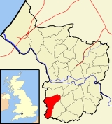
Bishopsworth is the name of both a council ward
of the city of Bristol
in the United Kingdom
, and a suburb
of the city which lies within that ward.
As well as the suburb of Bishopsworth, the ward contains the areas of Bedminster Down, Highridge and Withywood.
, England
, which was formerly a civil parish
.
The name may originally have been Bishport.
In 1928 the parish of Bedminster Down was created from the north of Bishopsworth in response to the development of the area. The parishes of Hartcliffe
and Withywood were separated off more recently.
Bishopsworth has an estimated population of 11,444 people (2001 Census
). Its municipal services are run by Bristol City Council whilst its local health services are managed by the Bristol South and West Primary Care Trust.
Local facilities include shops and pubs, a public library
and swimming pool
.
 The first church in Bishopsworth was a small chapel dedicated to St Peter and St Paul built under an arrangement in 1194 between Robert Arthur, lord of the manor
, and George de Dunster, prebend of Bedminster. The agreement provided for a chaplain to visit from Bedminster on Wednesdays, Fridays and Sundays. This provision continued until dissolution in 1540. The chapel was converted into three cottages which stood until the Corporation demolished them in 1961 to make way for a swimming pool.
people living in bishoph is 27,442 people.
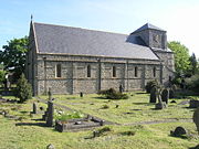
The present church, dedicated to St Peter, was built in 1841-43. The neo-Norman
design was the work of Samuel Charles Fripp. It is a grade II* listed building.
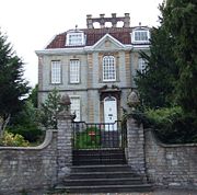 Bishopsworth Manor was built around 1720 and is grade II* listed. It was owned in the 1970s and 1980s by the late Denis Bristow who restored much of it to its present state.
 Bedminster Down is an area of Bristol
, England
.
Bedminster Down is a suburb of Bristol. Much of the area was built in the 1930s. It extends from Bedminster to Ashton, Bishopworth, Highridge and Uplands, and is a largely residential area. Much of the area is built over disused coal mines.
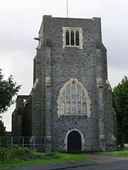
The Parish Church, built in 1927, is dedicated to St Oswald. The Methodist church in the area shut down on Sunday 31 August 2008 The Methodist church consisted of two buildings, the main chapel and a church hall. The main chapel is currently in use as a community arts centre. The church hall is again running Sunday morning services under the name Bedminster Down Church, which is a satellite church from Headley Park Church. This means that while Sunday services are held there all other church business is conducted by Headley Park Church
 Withywood is a district of Bristol
, England
, situated on the southern border of the city
, between Hartcliffe and Bishopsworth, just north of Dundry Hill.
It is a large estate, begun in the 1950s. The road links to Withywood are adequate, although they should improve with the proposed South Bristol Ring Road
Withywood has a number of primary schools: Fair Furlong, Four Acres, Gay Elms and St. Pius. There is a secondary comprehensive on Molesworth Drive. There is a relatively new secondary school, Merchants Academy, which opening in 2008, after the demolition of the former Withywood Community School. All of the schools have relatively large sports fields and grounds (Merchants Academy has 2 astro turfs, along with an onsite gym, also open for the public). Withywood also has its own 'University', a private home on the corner of Bishport Avenue and Queens Road where studying and lectures take place. They have also been a registered charity since 1996.
Queen's Road has a number of shops and the Amelia Nutt Health Clinic. Four Acres road also has shops directly opposite Sherrin Way bus terminus (the end of the journey) next to 'The Rusham' retirement homes.
It has a number of public houses: The Woods (Four Acres, now demolished), Queens Head, Rising Sun (both located on Queen's Road - Rising Sun now shut down) and the Elm Tree.
A big regeneration program is taking place around the area, new apartments on Hengrove Way and further development of The Junction shopping complex, and a proposal of a swimming pool and leisure complex alongside Cineworld, all within walking distance of Withywood. The Dundry View Neighbourhood Partnership works with residents in Bedminster Down, Bishopsworth, Hartcliffe, Headley Park, Highridge, Teyfant, Uplands, Whitchurch Park and Withywood.
Wards of the United Kingdom
A ward in the United Kingdom is an electoral district at sub-national level represented by one or more councillors. It is the primary unit of British administrative and electoral geography .-England:...
of the city of Bristol
Bristol
Bristol is a city, unitary authority area and ceremonial county in South West England, with an estimated population of 433,100 for the unitary authority in 2009, and a surrounding Larger Urban Zone with an estimated 1,070,000 residents in 2007...
in the United Kingdom
United Kingdom
The United Kingdom of Great Britain and Northern IrelandIn the United Kingdom and Dependencies, other languages have been officially recognised as legitimate autochthonous languages under the European Charter for Regional or Minority Languages...
, and a suburb
Suburb
The word suburb mostly refers to a residential area, either existing as part of a city or as a separate residential community within commuting distance of a city . Some suburbs have a degree of administrative autonomy, and most have lower population density than inner city neighborhoods...
of the city which lies within that ward.
As well as the suburb of Bishopsworth, the ward contains the areas of Bedminster Down, Highridge and Withywood.
Bishopsworth
Bishopsworth is a largely residential suburb in south BristolBristol
Bristol is a city, unitary authority area and ceremonial county in South West England, with an estimated population of 433,100 for the unitary authority in 2009, and a surrounding Larger Urban Zone with an estimated 1,070,000 residents in 2007...
, England
England
England is a country that is part of the United Kingdom. It shares land borders with Scotland to the north and Wales to the west; the Irish Sea is to the north west, the Celtic Sea to the south west, with the North Sea to the east and the English Channel to the south separating it from continental...
, which was formerly a civil parish
Civil parish
In England, a civil parish is a territorial designation and, where they are found, the lowest tier of local government below districts and counties...
.
The name may originally have been Bishport.
In 1928 the parish of Bedminster Down was created from the north of Bishopsworth in response to the development of the area. The parishes of Hartcliffe
Hartcliffe
Hartcliffe is the name of both a council ward and a district of the city of Bristol in the United Kingdom which lies within that ward. The ward contains the areas of Hartcliffe and Headley Park, as well as small portions of Withywood and Bishopsworth....
and Withywood were separated off more recently.
Bishopsworth has an estimated population of 11,444 people (2001 Census
United Kingdom Census 2001
A nationwide census, known as Census 2001, was conducted in the United Kingdom on Sunday, 29 April 2001. This was the 20th UK Census and recorded a resident population of 58,789,194....
). Its municipal services are run by Bristol City Council whilst its local health services are managed by the Bristol South and West Primary Care Trust.
Local facilities include shops and pubs, a public library
Library
In a traditional sense, a library is a large collection of books, and can refer to the place in which the collection is housed. Today, the term can refer to any collection, including digital sources, resources, and services...
and swimming pool
Swimming pool
A swimming pool, swimming bath, wading pool, or simply a pool, is a container filled with water intended for swimming or water-based recreation. There are many standard sizes; the largest is the Olympic-size swimming pool...
.
Church
Lord of the Manor
The Lordship of a Manor is recognised today in England and Wales as a form of property and one of three elements of a manor that may exist separately or be combined and may be held in moieties...
, and George de Dunster, prebend of Bedminster. The agreement provided for a chaplain to visit from Bedminster on Wednesdays, Fridays and Sundays. This provision continued until dissolution in 1540. The chapel was converted into three cottages which stood until the Corporation demolished them in 1961 to make way for a swimming pool.
people living in bishoph is 27,442 people.
The present church, dedicated to St Peter, was built in 1841-43. The neo-Norman
Norman architecture
About|Romanesque architecture, primarily English|other buildings in Normandy|Architecture of Normandy.File:Durham Cathedral. Nave by James Valentine c.1890.jpg|thumb|200px|The nave of Durham Cathedral demonstrates the characteristic round arched style, though use of shallow pointed arches above the...
design was the work of Samuel Charles Fripp. It is a grade II* listed building.
Bishopsworth Manor
Other listed buildings
The School House and attached school rooms in church road were built around 1840 in a Tudor Revival style and is grade II listed. Chestnut Court dates from the early 18th century in an early Georgian style.Bedminster Down
Bristol
Bristol is a city, unitary authority area and ceremonial county in South West England, with an estimated population of 433,100 for the unitary authority in 2009, and a surrounding Larger Urban Zone with an estimated 1,070,000 residents in 2007...
, England
England
England is a country that is part of the United Kingdom. It shares land borders with Scotland to the north and Wales to the west; the Irish Sea is to the north west, the Celtic Sea to the south west, with the North Sea to the east and the English Channel to the south separating it from continental...
.
Bedminster Down is a suburb of Bristol. Much of the area was built in the 1930s. It extends from Bedminster to Ashton, Bishopworth, Highridge and Uplands, and is a largely residential area. Much of the area is built over disused coal mines.
The Parish Church, built in 1927, is dedicated to St Oswald. The Methodist church in the area shut down on Sunday 31 August 2008 The Methodist church consisted of two buildings, the main chapel and a church hall. The main chapel is currently in use as a community arts centre. The church hall is again running Sunday morning services under the name Bedminster Down Church, which is a satellite church from Headley Park Church. This means that while Sunday services are held there all other church business is conducted by Headley Park Church
Withywood
Bristol
Bristol is a city, unitary authority area and ceremonial county in South West England, with an estimated population of 433,100 for the unitary authority in 2009, and a surrounding Larger Urban Zone with an estimated 1,070,000 residents in 2007...
, England
England
England is a country that is part of the United Kingdom. It shares land borders with Scotland to the north and Wales to the west; the Irish Sea is to the north west, the Celtic Sea to the south west, with the North Sea to the east and the English Channel to the south separating it from continental...
, situated on the southern border of the city
City
A city is a relatively large and permanent settlement. Although there is no agreement on how a city is distinguished from a town within general English language meanings, many cities have a particular administrative, legal, or historical status based on local law.For example, in the U.S...
, between Hartcliffe and Bishopsworth, just north of Dundry Hill.
It is a large estate, begun in the 1950s. The road links to Withywood are adequate, although they should improve with the proposed South Bristol Ring Road
Withywood has a number of primary schools: Fair Furlong, Four Acres, Gay Elms and St. Pius. There is a secondary comprehensive on Molesworth Drive. There is a relatively new secondary school, Merchants Academy, which opening in 2008, after the demolition of the former Withywood Community School. All of the schools have relatively large sports fields and grounds (Merchants Academy has 2 astro turfs, along with an onsite gym, also open for the public). Withywood also has its own 'University', a private home on the corner of Bishport Avenue and Queens Road where studying and lectures take place. They have also been a registered charity since 1996.
Queen's Road has a number of shops and the Amelia Nutt Health Clinic. Four Acres road also has shops directly opposite Sherrin Way bus terminus (the end of the journey) next to 'The Rusham' retirement homes.
It has a number of public houses: The Woods (Four Acres, now demolished), Queens Head, Rising Sun (both located on Queen's Road - Rising Sun now shut down) and the Elm Tree.
A big regeneration program is taking place around the area, new apartments on Hengrove Way and further development of The Junction shopping complex, and a proposal of a swimming pool and leisure complex alongside Cineworld, all within walking distance of Withywood. The Dundry View Neighbourhood Partnership works with residents in Bedminster Down, Bishopsworth, Hartcliffe, Headley Park, Highridge, Teyfant, Uplands, Whitchurch Park and Withywood.