

A13 (Switzerland)
Encyclopedia
The A13 is a motorway, at times an Autostrasse (expressway), which runs from St. Margrethen
in northeastern Switzerland
through to Ascona
in southern Switzerland, crossing the main chain of the Alps
in the Grisons area. It is the southern half of European route E43
.
, opposite Liechtenstein
. The motorway would begin from Haag through Reichenau. Then it would be an expressway again until after Mesocco
. The final kilometres linking it from Roveredo
to the A2
motorway would be an expressway. Today, the section from St. Margrethen through Haag has been thoroughly converted to a motorway. Due to the tough terrain, the transformation of the Graubünden
section into a full motorway would be difficult.
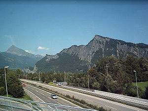 The route is challenging south of Chur
, capital of the Grisons. The year round opening of the route only became possible in 1967, when the San-Bernardino tunnel
was built, including the approaching branches of the A13. Therefore it sometimes appears to be more of a widened mountain road rather than a motorway or an expressway. For the whole of the ramps towards the culmination at San-Bernardino tunnel
, between Thusis and Soazza, there is no central structure to separate the two carriageway directions; each lane is about 50% larger than on a main road, and overtaking (using part of the carriageway reserved for the other direction) is actually allowed where signposted.
The expressway finds it way through the Alps by means of the San Bernardino tunnel, which is 6.6 km (4.1 mi) in length. It also passes the Viamala
gorge, where nocturnal shows tell the story of 2000 years of road construction through this obstacle (summer only).
motorway at the Sargans
junction at its northern branch, as well as the A2
motorway at Bellinzona
, south of the Alps. It connects also with main roads heading for Flims
-Disentis along the alps or Klosters
, St. Moritz
via Julier Pass
and Italy
(via the Splügen Pass
).
Main route: St. Margrethen
- Buchs SG - Sargans
- Landquart
- Chur
- Thusis
- Splügen - Cassanawald tunnel
- Hinterrhein
- San Bernardino
road tunnel - Pian San Giacomo - Roveredo
- Bellinzona
- Locarno
- Ascona
Speed limit: 120 km/h (75 mph) on all motorway parts; 100 km/h (65 mph) or at times 80 km/h (50 mph) on expressway parts. Speed checks do appear and penalties can be severe.
Tolls: Covered by CHF
40 annual motorway toll sticker.
, Canton of St. Gallen
right after the A1
. Afterwards, it crosses through the entire Rhine Valley, connects along the border with Austria and Liechtenstein, towards Sargans
, where A3
joins the A13.
The highway then heads to Chur
, the capital of Grisons, and turns southwards at Reichenau, where one can divert to drive along the Alps on the main road to Flims
-Disentis-Andermatt
-Brig
(summer only), whereas A13 leads to Thusis
(about 600 metres or 1,968.5 ft up).
From Thusis the A13 climbs an altitude difference of some 1000 metres to the 6.6 km (4.1 mi) long San Bernardino Tunnel at around 1650 metres (5,413.4 ft).
After the tunnel the road is marked by many galleries and strong avalanche-control curves back down into the Misox, using two long bridges to allow wide turns in this steep valley.
At Soazza
, shortly after Mesocco, the street again becomes a highway. The A13 continues downhill and joins, shortly before the Ticino capital Bellinzona
, merging with A2 at an altitude of 240 m (787 ft).
Between Ascona
and a roundabout south of Gaggiole in the Canton of Ticino, A13 is extended as the N13 highway; however, it is indicated by the crossed-out highway signs that Switzerland motorway sticker on this route is not necessary. Locarno
is bypassed with the 5-km long Mappo-Morettina tunnel. In this tunnel, there is one lane for each direction.
to the north has long been regarded as a particularly dangerous stretch: time and again, it experienced severe front-end collisions. In the period from 1979 to 2002, 96 people died on the A13, five times more than usual in Switzerland's highways.
On 16 September 2006, a fire broke out in the Viamala
Tunnel, after a head-on collision between a tour bus and a car, which killed nine people. Involved in the collision was a second passenger car. At least four other vehicles were affected.
St. Margrethen
St. Margrethen is a municipality in the Wahlkreis of Rheintal in the canton of St. Gallen in Switzerland.-Geography:...
in northeastern Switzerland
Switzerland
Switzerland name of one of the Swiss cantons. ; ; ; or ), in its full name the Swiss Confederation , is a federal republic consisting of 26 cantons, with Bern as the seat of the federal authorities. The country is situated in Western Europe,Or Central Europe depending on the definition....
through to Ascona
Ascona
Ascona is a municipality in the district of Locarno in the canton of Ticino in Switzerland.It is located on the shore of Lake Maggiore.The town is a popular tourist destination, and holds a yearly jazz festival, the Ascona Jazz Festival....
in southern Switzerland, crossing the main chain of the Alps
Main chain of the Alps
The Alpine divide is the central line of mountains that forms the water divide of the range. Main chains of mountain ranges are traditionally designated in this way, and generally include the highest peaks of a range; the Alps are something of an unusual case in that several significant groups of...
in the Grisons area. It is the southern half of European route E43
European route E43
European route E 43 is an E-road going from Bellinzona in Switzerland over Chur, Switzerland and Ulm, Germany to Würzburg, Germany....
.
Construction
The A13 started life as a road which was mainly an expressway, from the foggy beginnings at St. Margrethen through to HaagSennwald
Sennwald is a municipality in the Wahlkreis of Werdenberg in the canton of St. Gallen in Switzerland.-Geography:Sennwald has an area, , of . Of this area, 49.9% is used for agricultural purposes, while 31.5% is forested...
, opposite Liechtenstein
Liechtenstein
The Principality of Liechtenstein is a doubly landlocked alpine country in Central Europe, bordered by Switzerland to the west and south and by Austria to the east. Its area is just over , and it has an estimated population of 35,000. Its capital is Vaduz. The biggest town is Schaan...
. The motorway would begin from Haag through Reichenau. Then it would be an expressway again until after Mesocco
Mesocco
Mesocco is a municipality in the district of Moesa in the Swiss canton of Graubünden.-History:The first human settlement in the area dates back to the Mesolithic era. Stone tools dating to about 6000 BC have been found in the Silex section of the municipality. At the same site, Neolithic fire pits...
. The final kilometres linking it from Roveredo
Roveredo
Roveredo is a municipality in the district of Moësa in the canton of Graubünden in Switzerland.-Geography:Roveredo has an area, , of . Of this area, 8.6% is used for agricultural purposes, while 75% is forested...
to the A2
A2 (Switzerland)
The A2 is a motorway in Switzerland. It forms Switzerland's main north-south axis from Basel to Chiasso, meandering with a slight drift toward the east....
motorway would be an expressway. Today, the section from St. Margrethen through Haag has been thoroughly converted to a motorway. Due to the tough terrain, the transformation of the Graubünden
Graubünden
Graubünden or Grisons is the largest and easternmost canton of Switzerland. The canton shares borders with the cantons of Ticino, Uri, Glarus and St. Gallen and international borders with Italy, Austria and Liechtenstein...
section into a full motorway would be difficult.
Chur
Chur or Coire is the capital of the Swiss canton of Graubünden and lies in the northern part of the canton.-History:The name "chur" derives perhaps from the Celtic kora or koria, meaning "tribe", or from the Latin curia....
, capital of the Grisons. The year round opening of the route only became possible in 1967, when the San-Bernardino tunnel
San Bernardino (road tunnel)
The San Bernardino road tunnel is a road tunnel on the A13 motorway/expressway in southeastern Switzerland, completed in 1967 and replacing the San Bernardino Pass road. It begins near the town of San Bernardino, Graubünden and ends north in Hinterrhein....
was built, including the approaching branches of the A13. Therefore it sometimes appears to be more of a widened mountain road rather than a motorway or an expressway. For the whole of the ramps towards the culmination at San-Bernardino tunnel
San Bernardino (road tunnel)
The San Bernardino road tunnel is a road tunnel on the A13 motorway/expressway in southeastern Switzerland, completed in 1967 and replacing the San Bernardino Pass road. It begins near the town of San Bernardino, Graubünden and ends north in Hinterrhein....
, between Thusis and Soazza, there is no central structure to separate the two carriageway directions; each lane is about 50% larger than on a main road, and overtaking (using part of the carriageway reserved for the other direction) is actually allowed where signposted.
The expressway finds it way through the Alps by means of the San Bernardino tunnel, which is 6.6 km (4.1 mi) in length. It also passes the Viamala
Viamala
Viamala or Via Mala is an ancient and notorious section of the Hinterrhein River between Zillis-Reischen and Thusis in the Canton of Graubünden...
gorge, where nocturnal shows tell the story of 2000 years of road construction through this obstacle (summer only).
General information
The A13 continues the A1 on the shores of Bodensee, links with the A3A3 (Switzerland)
The A3 is a motorway in northeast Switzerland, running diagonally from France toward the southeast border, and passing by Zurich on the way. The total length of the A3 motorway spans roughly , but parts of the road share sections of the A1 and A2 motorways....
motorway at the Sargans
Sargans
Sargans is a municipality in the Wahlkreis of Sarganserland in the canton of St. Gallen in Switzerland.Sargans is known for its castle, which dates from before the founding of the Swiss Confederation in 1291...
junction at its northern branch, as well as the A2
A2 (Switzerland)
The A2 is a motorway in Switzerland. It forms Switzerland's main north-south axis from Basel to Chiasso, meandering with a slight drift toward the east....
motorway at Bellinzona
Bellinzona
Bellinzona is the administrative capital of the canton Ticino in Switzerland. The city is famous for its three castles that have been UNESCO World Heritage Sites since 2000....
, south of the Alps. It connects also with main roads heading for Flims
Flims
Flims is a municipality in the district of Imboden in the Swiss canton of Graubünden. The town of Flims is dominated by the Flimserstein which you can see from almost anywhere in the area....
-Disentis along the alps or Klosters
Klosters
Klosters-Serneus is a municipality in the district of Prättigau/Davos in the Swiss canton of Graubünden.Its well-known ski resort lies from Zurich, the nearest international airport. Transfer time is about 1.5 hours. Klosters is from Davos...
, St. Moritz
St. Moritz
St. Moritz is a resort town in the Engadine valley in Switzerland. It is a municipality in the district of Maloja in the Swiss canton of Graubünden...
via Julier Pass
Julier Pass
The Julier Pass is a mountain pass in Switzerland, in the Albula Range of the Alps. It connects the Engadin valley with the rest of Graubünden...
and Italy
Italy
Italy , officially the Italian Republic languages]] under the European Charter for Regional or Minority Languages. In each of these, Italy's official name is as follows:;;;;;;;;), is a unitary parliamentary republic in South-Central Europe. To the north it borders France, Switzerland, Austria and...
(via the Splügen Pass
Splügen Pass
The Splügen Pass is a high mountain pass which marks the boundary between the Lepontine and Rhaetian Alps....
).
Main route: St. Margrethen
St. Margrethen
St. Margrethen is a municipality in the Wahlkreis of Rheintal in the canton of St. Gallen in Switzerland.-Geography:...
- Buchs SG - Sargans
Sargans
Sargans is a municipality in the Wahlkreis of Sarganserland in the canton of St. Gallen in Switzerland.Sargans is known for its castle, which dates from before the founding of the Swiss Confederation in 1291...
- Landquart
Landquart
Landquart may be*the river that flows through the Prättigau valley, in the Canton of Graubünden, Switzerland, see Landquart River*a district in the Canton of Graubünden, see Landquart...
- Chur
Chur
Chur or Coire is the capital of the Swiss canton of Graubünden and lies in the northern part of the canton.-History:The name "chur" derives perhaps from the Celtic kora or koria, meaning "tribe", or from the Latin curia....
- Thusis
Thusis
Thusis is a municipality in the district of Hinterrhein in the Swiss canton of Graubünden.-Geography:Thusis has an area, , of . Of this area, 18% is used for agricultural purposes, while 58.2% is forested...
- Splügen - Cassanawald tunnel
Cassanawald tunnel
The Cassanawald tunnel is a 1.23 km tunnel on the A13 road in Switzerland, at an altitude of 1600 m.It is a few km northeast of the San Bernardino tunnel and southwest of the Roflatunnel....
- Hinterrhein
Hinterrhein, Switzerland
-External links:...
- San Bernardino
San Bernardino (road tunnel)
The San Bernardino road tunnel is a road tunnel on the A13 motorway/expressway in southeastern Switzerland, completed in 1967 and replacing the San Bernardino Pass road. It begins near the town of San Bernardino, Graubünden and ends north in Hinterrhein....
road tunnel - Pian San Giacomo - Roveredo
Roveredo
Roveredo is a municipality in the district of Moësa in the canton of Graubünden in Switzerland.-Geography:Roveredo has an area, , of . Of this area, 8.6% is used for agricultural purposes, while 75% is forested...
- Bellinzona
Bellinzona
Bellinzona is the administrative capital of the canton Ticino in Switzerland. The city is famous for its three castles that have been UNESCO World Heritage Sites since 2000....
- Locarno
Locarno
Locarno is the capital of the Locarno district, located on the northern tip of Lake Maggiore in the Swiss canton of Ticino, close to Ascona at the foot of the Alps. It has a population of about 15,000...
- Ascona
Ascona
Ascona is a municipality in the district of Locarno in the canton of Ticino in Switzerland.It is located on the shore of Lake Maggiore.The town is a popular tourist destination, and holds a yearly jazz festival, the Ascona Jazz Festival....
Speed limit: 120 km/h (75 mph) on all motorway parts; 100 km/h (65 mph) or at times 80 km/h (50 mph) on expressway parts. Speed checks do appear and penalties can be severe.
Tolls: Covered by CHF
Swiss franc
The franc is the currency and legal tender of Switzerland and Liechtenstein; it is also legal tender in the Italian exclave Campione d'Italia. Although not formally legal tender in the German exclave Büsingen , it is in wide daily use there...
40 annual motorway toll sticker.
Route details
The A13 starts in St. MargrethenSt. Margrethen
St. Margrethen is a municipality in the Wahlkreis of Rheintal in the canton of St. Gallen in Switzerland.-Geography:...
, Canton of St. Gallen
Canton of St. Gallen
The Canton of St. Gallen is a canton of Switzerland. St. Gallen is located in the north east of Switzerland. It covers an area of 2,026 km², and has a population of . , the population included 97,461 foreigners, or about 20.9% of the total population. The capital is St. Gallen. Spelling...
right after the A1
A1 (Switzerland)
The A1 is a motorway in Switzerland. It follows Switzerland's main east-west axis, from St. Margrethen in northeastern Switzerland's canton of St. Gallen through to Geneva in southwestern Switzerland...
. Afterwards, it crosses through the entire Rhine Valley, connects along the border with Austria and Liechtenstein, towards Sargans
Sargans
Sargans is a municipality in the Wahlkreis of Sarganserland in the canton of St. Gallen in Switzerland.Sargans is known for its castle, which dates from before the founding of the Swiss Confederation in 1291...
, where A3
A3 (Switzerland)
The A3 is a motorway in northeast Switzerland, running diagonally from France toward the southeast border, and passing by Zurich on the way. The total length of the A3 motorway spans roughly , but parts of the road share sections of the A1 and A2 motorways....
joins the A13.
The highway then heads to Chur
Chur
Chur or Coire is the capital of the Swiss canton of Graubünden and lies in the northern part of the canton.-History:The name "chur" derives perhaps from the Celtic kora or koria, meaning "tribe", or from the Latin curia....
, the capital of Grisons, and turns southwards at Reichenau, where one can divert to drive along the Alps on the main road to Flims
Flims
Flims is a municipality in the district of Imboden in the Swiss canton of Graubünden. The town of Flims is dominated by the Flimserstein which you can see from almost anywhere in the area....
-Disentis-Andermatt
Andermatt
Andermatt is a municipality in the canton of Uri in Switzerland.With Realp and Hospental, it is located in the Urseren valley, south of Altdorf.-Geography:...
-Brig
Brig
A brig is a sailing vessel with two square-rigged masts. During the Age of Sail, brigs were seen as fast and manoeuvrable and were used as both naval warships and merchant vessels. They were especially popular in the 18th and early 19th centuries...
(summer only), whereas A13 leads to Thusis
Thusis
Thusis is a municipality in the district of Hinterrhein in the Swiss canton of Graubünden.-Geography:Thusis has an area, , of . Of this area, 18% is used for agricultural purposes, while 58.2% is forested...
(about 600 metres or 1,968.5 ft up).
From Thusis the A13 climbs an altitude difference of some 1000 metres to the 6.6 km (4.1 mi) long San Bernardino Tunnel at around 1650 metres (5,413.4 ft).
After the tunnel the road is marked by many galleries and strong avalanche-control curves back down into the Misox, using two long bridges to allow wide turns in this steep valley.
At Soazza
Soazza
Soazza is a municipality in the district of Moesa in the Swiss canton of Graubünden.-Geography:Soazza has an area, , of . Of this area, 7.2% is used for agricultural purposes, while 53.7% is forested...
, shortly after Mesocco, the street again becomes a highway. The A13 continues downhill and joins, shortly before the Ticino capital Bellinzona
Bellinzona
Bellinzona is the administrative capital of the canton Ticino in Switzerland. The city is famous for its three castles that have been UNESCO World Heritage Sites since 2000....
, merging with A2 at an altitude of 240 m (787 ft).
Between Ascona
Ascona
Ascona is a municipality in the district of Locarno in the canton of Ticino in Switzerland.It is located on the shore of Lake Maggiore.The town is a popular tourist destination, and holds a yearly jazz festival, the Ascona Jazz Festival....
and a roundabout south of Gaggiole in the Canton of Ticino, A13 is extended as the N13 highway; however, it is indicated by the crossed-out highway signs that Switzerland motorway sticker on this route is not necessary. Locarno
Locarno
Locarno is the capital of the Locarno district, located on the northern tip of Lake Maggiore in the Swiss canton of Ticino, close to Ascona at the foot of the Alps. It has a population of about 15,000...
is bypassed with the 5-km long Mappo-Morettina tunnel. In this tunnel, there is one lane for each direction.
Serious accidents
Originally, a largely non-divided section of the expressway from SargansSargans
Sargans is a municipality in the Wahlkreis of Sarganserland in the canton of St. Gallen in Switzerland.Sargans is known for its castle, which dates from before the founding of the Swiss Confederation in 1291...
to the north has long been regarded as a particularly dangerous stretch: time and again, it experienced severe front-end collisions. In the period from 1979 to 2002, 96 people died on the A13, five times more than usual in Switzerland's highways.
On 16 September 2006, a fire broke out in the Viamala
Viamala
Viamala or Via Mala is an ancient and notorious section of the Hinterrhein River between Zillis-Reischen and Thusis in the Canton of Graubünden...
Tunnel, after a head-on collision between a tour bus and a car, which killed nine people. Involved in the collision was a second passenger car. At least four other vehicles were affected.
Relocation of heavy traffic on the rail transit
As a major transit route, shifting traffic from the A13 is a major concern. For the future, the introduction of an Alpentransitbörse is being discussed.Junction list
| Junctions | ||||||||||||||||||||||||||||||||||||||||||||||||||||||||||||||||||||||||||||||||||||||||||||||||||||||||||||||||||||||||||||||||||||||||||||||||||||||||||||||||||||||||||||||||||||||||||||||||||||||||||||||||||||||||||||||||||||||||||||||||||||||||||||||||||||||||||||||||
|
||||||||||||||||||||||||||||||||||||||||||||||||||||||||||||||||||||||||||||||||||||||||||||||||||||||||||||||||||||||||||||||||||||||||||||||||||||||||||||||||||||||||||||||||||||||||||||||||||||||||||||||||||||||||||||||||||||||||||||||||||||||||||||||||||||||||||||||||


