
2002 Pacific hurricane season
Encyclopedia
The 2002 Pacific hurricane season was an event in tropical cyclone meteorology. The most notable storm that year was Hurricane Kenna
, which reached Category 5 on the Saffir-Simpson Hurricane Scale
. It made landfall near Puerto Vallarta
, in the Mexican state of Jalisco
, on October 25. It killed four people and was one of the most powerful hurricanes to ever strike the western coast of Mexico, hitting with winds of 140 mph (the strongest since Hurricane Madeline
in 1976). Elsewhere, Tropical Storm Julio made landfall in Mexico
, and Tropical Storm Boris dumped torrential rain along the Mexican coast, although it remained offshore.
The season officially began on May 15 in the eastern Pacific, and June 1 in the central Pacific. It ended on November 30. These dates delimit the time when most tropical cyclone
s form in this part of the Pacific Ocean
. The first system formed on May 24 and the final depression dissipated on November 16.
Other storms were individually unusual. Hurricanes Elida
and Hernan
also reached Category 5 intensity, but neither did any damage. Hurricane Fausto
, while it had no effect on land, regenerated into a tiny tropical storm at a very high latitude.
. In practice, however, the season lasted from May 24, the formation date of its first system, to November 16, the dissipation date of the last.
There were twelve tropical storms in the eastern Pacific Ocean in the 2002 season. Of those, six became hurricanes, of which five became major hurricanes by reaching Category 3 or higher on the Saffir Simpson Scale
. Three reached Category 5 intensity, a record shared with the 1994 season
. Four tropical depressions formed and dissipated before reaching the intensity of a named storm. In the Central Pacific Hurricane Center
's area of responsibility
, one tropical storm and two hurricanes formed, of which one was a major hurricane. In the eastern Pacific proper, the season saw below average activity in terms of the number of systems, but about average activity in terms of the strength of storms. A moderately strong El Niño, ongoing during the season, may have contributed to the disproportionate number of major hurricanes, as well as reduced activity in the Atlantic
. Also of note this season is an unusual gap in storm formation during the first three weeks of August. That time usually sees several nameable storms, but for some reason there were none.
Only three systems, Tropical Storms Boris and Julio and Hurricane Kenna
, had significant impact on land. Julio and Kenna were the only landfalls. Most of the season's impact, including all casualties and most of the damage, was due to Kenna.
and a gale over the Gulf of Tehuantepec
formed Tropical Depression One-E on May 24. It slowly strengthened into the first tropical storm of the season two days later. Alma then turned north, moving near the edge of a subtropical ridge
over Mexico. Its rate of intensification picked up, and Alma became a hurricane on May 28. Alma reached Category 3 intensity on May 30. The hurricane began to weaken almost immediately thereafter under the influence of wind shear and cool water. Alma rapidly fell apart, and degenerated into a weak low pressure area
by June 1.
The hurricane was of no threat to land. Alma was one of the earliest major hurricanes in the east Pacific, and the second-strongest May hurricane. The only other May major hurricane was Adolph
in 2001.
spawned Tropical Depression Two-E. It became a tropical storm the next day. After peaking on June 9, with a pressure of 997 mb, steering currents collapsed and Boris stalled out in the ocean between two ridges of high pressure. Shear
increased, and the cyclone weakened to a depression on June 10. The next day, Boris degenerated into a remnant low. The remnant drifted east and then southeast before dissipating on June 12.
Boris dumped heavy rains on sections of the Mexican coast. The maximum amount was 10.6 inches (269.2 mm) at San Felipe Usila
. These rains damaged several homes at an unspecified location. In addition, rainfall damaged several homes in Tequila, Jalisco
, but the National Hurricane Center does not think that it is likely that Boris caused this rain. There were no deaths.
. By June 29, the depression had become a remnant low, which hung on as a swirl of clouds for a few more days.
drifted to a location south of Puerto Ángel
, Oaxaca
, and organized into Tropical Depression Four-E on July 9. It moved westward through a hostile environment of strong shear. The wind shear disrupted the cyclone's convection and weakened its circulation. Despite the shear, the depression strengthened into a tropical storm early on July 12 and was named Cristina. This broke down the steering ridge, and Cristina turned to the north and peaked on July 14. Then, the wind shear won out and Cristina quickly weakened. Cristina dissipated into a swirl of clouds on July 16, without ever threatening land. No impact was reported.
. Douglas's forward speed increased due to a strong ridge
of high pressure
. The hurricane continued to decay, and fell to a tropical storm on July 24 and a tropical depression two days later. Convection ceased on July 26, and a swirl of clouds was all that remained. The remnant lost its closed circulation and degenerated later that day as it continued to accelerate. Douglas had no impact on land.
generated into Tropical Depression Six-E on July 23. It moved westward and reached storm strength 12 hours after it formed. Elida rapidly deepened, developing a "pinhole" eye, becoming a hurricane on July 24 and a major hurricane six hours later. Elida's rapid intensification continued, becoming a Category 5 hurricane for six hours on July 25.
Despite moving over warm waters, Elida began to weaken because it began an eyewall replacement cycle
. When the cycle ended, the cyclone was over cooler water and unsteadily weakened. Elida fell to a tropical storm on July 27, then degenerated into a remnant low and turned to the northeast. The remnant dissipated over the open ocean about 535 mi (861 km) west of Los Angeles, California
.
Elida is one of the fastest intensifying eastern Pacific hurricanes. Its rate of intensification is rivaled only by 1997's
Linda
. Elida had no direct impact on land. However, it did send heavy waves along the shores of Mexico. No one was killed and there was no damage.
. The system did not strengthen much, and development was halted when wind shear destroyed the system on August 8. The depression never came near land and hence no one was killed or injured. Like Tropical Depression Three-E, this cyclone was forecast to reach tropical storm intensity, but never did.
's area of responsibility on August 27. The tropical cyclone dropped to a depression and spun down into a non-convective swirl of clouds on August 28.
Fausto's remnants passed north of the Hawaiian Islands
uneventfully until they interacted with a tropical upper-tropospheric trough (TUTT) on August 30. In combination with warm waters, a tropical depression with some subtropical features
developed. At this time it was located around latitude 30°N
. By September 1, Fausto had redeveloped into a tiny but tropical ministorm. Its rebirth was brief, however, as a mid-latitude cyclone
absorbed the system early on September 3.
Fausto's regeneration north of Hawaii
was unusual but not unprecedented. The other time this happened since 1966 was in the 1975 season
. That time, another TUTT absorbed the remnant of Hurricane Ilsa, which led to the formation of an unnamed hurricane
at high latitude. Other tropical cyclones have strengthened north of Hawaii
, but the actual formation of one is rare.
weakened the storm to a depression on August 27. Alika dissipated the next day, having never threatened land.
south of Hawaii organized into Tropical Depression Two-C on August 27 and strengthened into Tropical Storm Ele six hours later. Despite the nearby presence of Alika, Ele developed rapidly and strengthened into a hurricane on August 28. After contributing to the demise of Alika, Ele continued strengthening. It reached Category 2 intensity late on August 28 and became a major hurricane six hours later. Ele then crossed the International Date Line
and became a typhoon in the 2002 Pacific typhoon season
. Typhoon Ele turned to the northwest after crossing the dateline and continued to strengthen. It reached Category 4 before turning north and weakening again. After briefly restrengthening back into a Category 4, the typhoon declined and turned to the northwest. Ele fell to a tropical storm on September 7, a depression on September 9, and dissipated shortly after that. Ele was of no threat to land.
organized into Tropical Depression Ten-E on August 30. It headed west-northwest and quickly intensified into a tropical storm and later a hurricane. Hernan then began a rapid deepening, and reached Category 5 intensity on September 1. It was at that intensity for 12 hours. Hernan then tracked over cooler waters. The storm weakened steadily, and wind shear continued its deterioration. Hernan degenerated into a remnant low on September 6. The low turned to the southwest and dissipated three days later.
Hernan passed close enough to Socorro Island
to bring strong winds to the island. In addition, the hurricane's large and powerful wind field caused waves between 12 feet (3.7 m) and 20 feet (6.1 m) in height and strong rip current
s on the southwest coast of California
. Other than these areas, Hernan had no significant impact on land.
formed into a tropical cyclone on September 5. It tracked northwestward, before turning southwest. It weakened into a remnant low on September 8. The remnant turned north and dissipated on September 10 offshore of the Baja California peninsula
. The cyclone was nearly a tropical storm when it peaked on September 6. It was forecast to become a tropical storm and pass close to the peninsula. This prompted a tropical storm warning and a hurricane watch. With the weakening of the cyclone the watch and warning were discontinued. No damage or casualties were reported in association with this tropical cyclone.
in the Atlantic organized into Tropical Depression Twelve-E on September 15. It strengthened into Tropical Storm Iselle the next day. The storm headed northwest and paralleled the coast of Mexico. Iselle strengthened into nearly a hurricane late on September 17. While near its peak intensity, a trough
abruptly recurved the system to the northeast. Shear
also increased, and Iselle fell apart. It weakened to a depression on September 19. It degenerated the next day and rapidly disintegrated, dissipating on September 20. Iselle never nade landfall.
Iselle threatened parts of southwestern Mexico and warnings and watches
were issued for that area. Heavy rains were reported over parts of the Baja California Peninsula
. The highest amount of rainfall was 6.16 inches (156.5 mm) at Guadeloupe and Mulege, Baja California Sur. There were no reports of damage or casualties.
in the Atlantic
developed a circulation on September 23 and organized into Tropical Depression Thirteen-E on September 25. The depression headed northward and strengthened into a tropical storm the same day. Julio turned to the northwest and peaked just before landfall near Lázaro Cárdenas, Michoacán
, on September 26. The storm quickly dissipated over Mexico.
No one was killed by Julio. In Guerrero
, around 100 houses in Acapulco
and Zihuatanejo
were damaged or washed away by flash flood
ing. The highest rainfall reported was 16.1 inches (408.9 mm) at Zihuatanajo and La Unión, Guerrero
.
Hurricane Kenna was the third-strongest Pacific hurricane
to make landfall ever recorded. It was also the second-strongest October hurricane in any season, and the third strongest Pacific hurricane overall. In San Blas, Nayarit
, 8800 people were affected; 1540 houses were damaged or destroyed, which was 80% to 90% of houses in the town. In Santiago Ixcluintla, 3770 houses were damaged. Agriculture in the affected area was disrupted. Farmers required aid, and many fruit crops were destroyed. Tourism in Puerto Vallarta
was disrupted, with much of the damage to hotels. Insurance companies reported that Kenna's total damage was $96 million (2002 USD
).
Kenna killed four people in Mexico and injured over a hundred. The low death toll is likely due to massive evacuations in San Blas, Nayarit
, and elsewhere ahead of the hurricane.
located over the open ocean organized into Tropical Depression Fifteen-E on October 22. It strengthened into a tropical storm the next day. Just after that, shear
increased. Lowell's convection was disrupted, and its center of circulation became exposed. The cyclone crossed into the Central Pacific Hurricane Center
's area of responsibility on October 26. The shear relaxed, and the depression restrengthened into a tropical storm. Lowell drifted in slow steering currents until it approached the next storm of the season, Huko. The proximity of the other system caused a gradual weakening, and Lowell dissipated on October 31.
. The depression then intensified slowly and on October 26 had intensified enough to be designated as a tropical storm, and was named Huko. Huko intensified into a hurricane later that day, reaching wind speeds of 75 mph (120.7 km/h). The storm stayed at this intensity during the next day, and then weakened in to a tropical storm, due to some interaction with Tropical Storm Lowell which was located at the other end of the central Pacific Ocean.
After Lowell's demise on October 31, Huko started to move towards the west and became a hurricane again later that day. Huko then reached its peak 1-minute wind speeds of 85 mph (136.8 km/h) early on November 1. On November 2 Huko passed to the south of a high pressure cell, causing it to accelerate towards the International dateline. It then reached the dateline early the next day and crossed over in to the Western Pacific, becoming a typhoon in the 2002 Pacific typhoon season
.
. Despite being located in a hostile environment, it managed to organize into a tropical depression on November 14. It was briefly forecast to strengthen into a tropical storm. However, wind shear
prevented that. It degenerated into a remnant low on November 16 and dissipated soon after that.
Accumulated Cyclone Energy
(ACE) is a measure of the activity of a hurricane season. It is calculated by squaring the windspeed of a cyclone with at least tropical storm-force winds every six hours, summing the results, and dividing that total by 104. As a tropical cyclone does not have gale-force winds until it becomes a tropical storm, tropical depressions are not included in these tables. For all storms, ACE is given to three significant figures
. The ACE in the east Pacific proper (140°W
to North America) is given; the ACE in the central Pacific (the International Date Line
to 140°W
) is given in brackets.
The table includes the ACE for Ele and Huko accumulated only when those storms were located east of the dateline; their ACE west of the dateline is part of the totals of the 2002 typhoon season
.
The National Hurricane Center uses ACE to rank hurricane seasons as above-normal, near-normal, and below-normal. It defines below-normal as having an ACE less than 95*104 kt2 kt2; It defines above normal as having an ACE above 150*104 kt2 along with the numbers of any two of the following above average: tropical storms (15), hurricanes (9), or major hurricanes (4); It defines near-normal as having an ACE between 100*104 kt2 and 150*104 kt2, or an ACE above 150*104 kt2 with fewer than two of the numbers of the following above average: tropical storms (15), hurricanes (9), or major hurricanes (4).
The 2002 season had a total of fifteen tropical storms, eight hurricanes, and 7 major hurricanes. The total ACE of the season was 101*104 kt2 in the east Pacific proper. This qualifies the 2002 season as near-normal.
. This is the same list used for the 1996 season
. Names that were not assigned are marked in gray.
In addition to these, three central Pacific names, taken from a list used for storms forming in the jurisdiction of the Central Pacific Hurricane Center
, were used during this season — Alika, Ele, and Huko
.
retired one name in the spring of 2003: Kenna. It was replaced in the 2008 Pacific hurricane season by Karina.
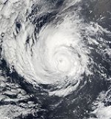
Hurricane Kenna
Hurricane Kenna was the second-most intense Pacific hurricane to strike the west coast of Mexico in recorded history. Kenna was the sixteenth tropical depression, thirteenth tropical storm, seventh hurricane, sixth major hurricane, and third Category 5 hurricane of the 2002 Pacific hurricane season...
, which reached Category 5 on the Saffir-Simpson Hurricane Scale
Saffir-Simpson Hurricane Scale
The Saffir–Simpson Hurricane Scale , or the Saffir–Simpson Hurricane Wind Scale , classifies hurricanes — Western Hemisphere tropical cyclones that exceed the intensities of tropical depressions and tropical storms — into five categories distinguished by the intensities of their sustained winds...
. It made landfall near Puerto Vallarta
Puerto Vallarta
Puerto Vallarta is a Mexican balneario resort city situated on the Pacific Ocean's Bahía de Banderas.The 2010 census reported Puerto Vallarta's population as 255,725 making it the sixth-largest city in the state of Jalisco...
, in the Mexican state of Jalisco
Jalisco
Jalisco officially Estado Libre y Soberano de Jalisco is one of the 31 states which, with the Federal District, comprise the 32 Federal Entities of Mexico. It is located in Western Mexico and divided in 125 municipalities and its capital city is Guadalajara.It is one of the more important states...
, on October 25. It killed four people and was one of the most powerful hurricanes to ever strike the western coast of Mexico, hitting with winds of 140 mph (the strongest since Hurricane Madeline
1976 Pacific hurricane season
The 1976 Pacific hurricane season was a very deadly and costly one. Hurricanes Kathleen, Liza, and Madeline were the most notable storms this year. Hurricane Kathleen caused death and destruction in California and Arizona due to flooding. Hurricane Liza was the deadliest storm of the season when it...
in 1976). Elsewhere, Tropical Storm Julio made landfall in Mexico
Mexico
The United Mexican States , commonly known as Mexico , is a federal constitutional republic in North America. It is bordered on the north by the United States; on the south and west by the Pacific Ocean; on the southeast by Guatemala, Belize, and the Caribbean Sea; and on the east by the Gulf of...
, and Tropical Storm Boris dumped torrential rain along the Mexican coast, although it remained offshore.
The season officially began on May 15 in the eastern Pacific, and June 1 in the central Pacific. It ended on November 30. These dates delimit the time when most tropical cyclone
Tropical cyclone
A tropical cyclone is a storm system characterized by a large low-pressure center and numerous thunderstorms that produce strong winds and heavy rain. Tropical cyclones strengthen when water evaporated from the ocean is released as the saturated air rises, resulting in condensation of water vapor...
s form in this part of the Pacific Ocean
Pacific Ocean
The Pacific Ocean is the largest of the Earth's oceanic divisions. It extends from the Arctic in the north to the Southern Ocean in the south, bounded by Asia and Australia in the west, and the Americas in the east.At 165.2 million square kilometres in area, this largest division of the World...
. The first system formed on May 24 and the final depression dissipated on November 16.
Other storms were individually unusual. Hurricanes Elida
Hurricane Elida (2002)
Hurricane Elida was the first hurricane of the 2002 Pacific hurricane season to reach Category 5 strength on the Saffir-Simpson Hurricane Scale. Forming on July 23 from a tropical wave, the storm rapidly intensified from a tropical depression into a Category 5 in two days and lasted...
and Hernan
Hurricane Hernan (2002)
Hurricane Hernan was the second of three Category 5 hurricanes during the 2002 Pacific hurricane season. The twelfth tropical cyclone, tenth named storm and sixth hurricane of the season, Hernan originated from a tropical wave that formed in the Atlantic Ocean and crossed to the Pacific Ocean...
also reached Category 5 intensity, but neither did any damage. Hurricane Fausto
Hurricane Fausto (2002)
Hurricane Fausto was a long-lived tropical cyclone that formed during the 2002 Pacific hurricane season. The eighth tropical cyclone and fifth named storm of the season, Fausto developed on August 21 from a tropical wave that had crossed the Atlantic, and entered the Pacific on August 17...
, while it had no effect on land, regenerated into a tiny tropical storm at a very high latitude.
Season summary
The 2002 Pacific hurricane season officially started May 15, 2002 in the eastern Pacific, and June 1, 2002 in the central Pacific, and lasted until November 30, 2002. These dates conventionally delimit the period of each year when most tropical cyclones form in the northeastern Pacific OceanPacific Ocean
The Pacific Ocean is the largest of the Earth's oceanic divisions. It extends from the Arctic in the north to the Southern Ocean in the south, bounded by Asia and Australia in the west, and the Americas in the east.At 165.2 million square kilometres in area, this largest division of the World...
. In practice, however, the season lasted from May 24, the formation date of its first system, to November 16, the dissipation date of the last.
There were twelve tropical storms in the eastern Pacific Ocean in the 2002 season. Of those, six became hurricanes, of which five became major hurricanes by reaching Category 3 or higher on the Saffir Simpson Scale
Saffir-Simpson Hurricane Scale
The Saffir–Simpson Hurricane Scale , or the Saffir–Simpson Hurricane Wind Scale , classifies hurricanes — Western Hemisphere tropical cyclones that exceed the intensities of tropical depressions and tropical storms — into five categories distinguished by the intensities of their sustained winds...
. Three reached Category 5 intensity, a record shared with the 1994 season
1994 Pacific hurricane season
The 1994 Pacific hurricane season officially started on May 15, 1994 in the eastern Pacific, and on June 1, 1994 in the central Pacific, and lasted until November 30, 1994. These dates conventionally delimit the period of each year when most tropical cyclones form in the northeastern Pacific Ocean...
. Four tropical depressions formed and dissipated before reaching the intensity of a named storm. In the Central Pacific Hurricane Center
Central Pacific Hurricane Center
The Central Pacific Hurricane Center of the United States National Weather Service is the official body responsible for tracking and issuing tropical cyclone warnings, watches, advisories, discussions, and statements for the Central North Pacific Basin...
's area of responsibility
Area of responsibility
Area Of Responsibility is a pre-defined geographic region assigned to a Combatant commanders of the Unified Command Plan , that are used to define an area with specific geographic boundaries where they have the authority to plan and conduct operations; for which a force, or component commander...
, one tropical storm and two hurricanes formed, of which one was a major hurricane. In the eastern Pacific proper, the season saw below average activity in terms of the number of systems, but about average activity in terms of the strength of storms. A moderately strong El Niño, ongoing during the season, may have contributed to the disproportionate number of major hurricanes, as well as reduced activity in the Atlantic
2002 Atlantic hurricane season
The 2002 Atlantic hurricane season was an average Atlantic hurricane season, officially starting on June 1, 2002 and ending on November 30, dates which conventionally limit the period of each year when tropical cyclones in the Atlantic Ocean tend to form...
. Also of note this season is an unusual gap in storm formation during the first three weeks of August. That time usually sees several nameable storms, but for some reason there were none.
Only three systems, Tropical Storms Boris and Julio and Hurricane Kenna
Hurricane Kenna
Hurricane Kenna was the second-most intense Pacific hurricane to strike the west coast of Mexico in recorded history. Kenna was the sixteenth tropical depression, thirteenth tropical storm, seventh hurricane, sixth major hurricane, and third Category 5 hurricane of the 2002 Pacific hurricane season...
, had significant impact on land. Julio and Kenna were the only landfalls. Most of the season's impact, including all casualties and most of the damage, was due to Kenna.
Hurricane Alma
A complex formation involving a tropical waveTropical wave
Tropical waves, easterly waves, or tropical easterly waves, also known as African easterly waves in the Atlantic region, are a type of atmospheric trough, an elongated area of relatively low air pressure, oriented north to south, which move from east to west across the tropics causing areas of...
and a gale over the Gulf of Tehuantepec
Gulf of Tehuantepec
Gulf of Tehuantepec is a large body of water on the Pacific coast of the Isthmus of Tehuantepec, southeastern Mexico, at . Most of the hurricanes that form in the Eastern Pacific organize in or near this body of water...
formed Tropical Depression One-E on May 24. It slowly strengthened into the first tropical storm of the season two days later. Alma then turned north, moving near the edge of a subtropical ridge
Ridge (meteorology)
A ridge is an elongated region of relatively high atmospheric pressure, the opposite of a trough....
over Mexico. Its rate of intensification picked up, and Alma became a hurricane on May 28. Alma reached Category 3 intensity on May 30. The hurricane began to weaken almost immediately thereafter under the influence of wind shear and cool water. Alma rapidly fell apart, and degenerated into a weak low pressure area
Low pressure area
A low-pressure area, or "low", is a region where the atmospheric pressure at sea level is below that of surrounding locations. Low-pressure systems form under areas of wind divergence which occur in upper levels of the troposphere. The formation process of a low-pressure area is known as...
by June 1.
The hurricane was of no threat to land. Alma was one of the earliest major hurricanes in the east Pacific, and the second-strongest May hurricane. The only other May major hurricane was Adolph
Hurricane Adolph (2001)
Hurricane Adolph of the 2001 Pacific hurricane season was the first and only East Pacific hurricane in May to reach Category 4 strength on the Saffir-Simpson Hurricane Scale since record keeping began in the East Pacific...
in 2001.
Tropical Storm Boris
On June 8, an area of disturbed weather that had absorbed a tropical waveTropical wave
Tropical waves, easterly waves, or tropical easterly waves, also known as African easterly waves in the Atlantic region, are a type of atmospheric trough, an elongated area of relatively low air pressure, oriented north to south, which move from east to west across the tropics causing areas of...
spawned Tropical Depression Two-E. It became a tropical storm the next day. After peaking on June 9, with a pressure of 997 mb, steering currents collapsed and Boris stalled out in the ocean between two ridges of high pressure. Shear
Wind shear
Wind shear, sometimes referred to as windshear or wind gradient, is a difference in wind speed and direction over a relatively short distance in the atmosphere...
increased, and the cyclone weakened to a depression on June 10. The next day, Boris degenerated into a remnant low. The remnant drifted east and then southeast before dissipating on June 12.
Boris dumped heavy rains on sections of the Mexican coast. The maximum amount was 10.6 inches (269.2 mm) at San Felipe Usila
San Felipe Usila
San Felipe Usila is a town and municipality in Oaxaca in south-western Mexico. The municipality covers an area of 255.17 km².It is part of the Tuxtepec District of the Papaloapan Region.As of 2005, the municipality had a total population of 11642....
. These rains damaged several homes at an unspecified location. In addition, rainfall damaged several homes in Tequila, Jalisco
Tequila, Jalisco
Santiago de Tequila is a town and municipality located in the state of Jalisco about 60 km from the city of Guadalajara. Tequila is best known as being the birthplace of the drink that bears its name, “tequila,” which is made from the blue agave plant, native to this area. The heart of the...
, but the National Hurricane Center does not think that it is likely that Boris caused this rain. There were no deaths.
Tropical Depression Three-E
A tropical wave that crossed Central America organized and developed into a depression on June 27. Contrary to forecasts, the depression did not strengthen further because of strong wind shearWind shear
Wind shear, sometimes referred to as windshear or wind gradient, is a difference in wind speed and direction over a relatively short distance in the atmosphere...
. By June 29, the depression had become a remnant low, which hung on as a swirl of clouds for a few more days.
Tropical Storm Cristina
An area of disturbed weather near PanamaPanama
Panama , officially the Republic of Panama , is the southernmost country of Central America. Situated on the isthmus connecting North and South America, it is bordered by Costa Rica to the northwest, Colombia to the southeast, the Caribbean Sea to the north and the Pacific Ocean to the south. The...
drifted to a location south of Puerto Ángel
Puerto Ángel
Puerto Ángel is a small coastal town in the Mexican state of Oaxaca located in the municipality of San Pedro Pochutla. It, along with San Agustinillo and Playa Zipolite are known as the "Riviera Oaxaqueña. It is located 9 km south of city of Pochutla fifty km west of Huatulco and eighty km...
, Oaxaca
Oaxaca
Oaxaca , , officially Estado Libre y Soberano de Oaxaca is one of the 31 states which, along with the Federal District, comprise the 32 federative entities of Mexico. It is divided into 571 municipalities; of which 418 are governed by the system of customs and traditions...
, and organized into Tropical Depression Four-E on July 9. It moved westward through a hostile environment of strong shear. The wind shear disrupted the cyclone's convection and weakened its circulation. Despite the shear, the depression strengthened into a tropical storm early on July 12 and was named Cristina. This broke down the steering ridge, and Cristina turned to the north and peaked on July 14. Then, the wind shear won out and Cristina quickly weakened. Cristina dissipated into a swirl of clouds on July 16, without ever threatening land. No impact was reported.
Hurricane Douglas
A relaxation of wind shear allowed a tropical wave to organize and become Tropical Depression Five-E on July 20. The depression rapidly strengthened into a tropical storm that moved northward, turned westward, and then northwestward. Douglas strengthened into a hurricane on July 22 and peaked as a Category 2 the next day. It began to weaken due to cooler waters and an eyewall replacement cycleEyewall replacement cycle
Eyewall replacement cycles, also called concentric eyewall cycles, naturally occur in intense tropical cyclones, generally with winds greater than 185 km/h , or major hurricanes...
. Douglas's forward speed increased due to a strong ridge
Ridge (meteorology)
A ridge is an elongated region of relatively high atmospheric pressure, the opposite of a trough....
of high pressure
High pressure area
A high-pressure area is a region where the atmospheric pressure at the surface of the planet is greater than its surrounding environment. Winds within high-pressure areas flow outward due to the higher density air near their center and friction with land...
. The hurricane continued to decay, and fell to a tropical storm on July 24 and a tropical depression two days later. Convection ceased on July 26, and a swirl of clouds was all that remained. The remnant lost its closed circulation and degenerated later that day as it continued to accelerate. Douglas had no impact on land.
Hurricane Elida
A tropical waveTropical wave
Tropical waves, easterly waves, or tropical easterly waves, also known as African easterly waves in the Atlantic region, are a type of atmospheric trough, an elongated area of relatively low air pressure, oriented north to south, which move from east to west across the tropics causing areas of...
generated into Tropical Depression Six-E on July 23. It moved westward and reached storm strength 12 hours after it formed. Elida rapidly deepened, developing a "pinhole" eye, becoming a hurricane on July 24 and a major hurricane six hours later. Elida's rapid intensification continued, becoming a Category 5 hurricane for six hours on July 25.
Despite moving over warm waters, Elida began to weaken because it began an eyewall replacement cycle
Eyewall replacement cycle
Eyewall replacement cycles, also called concentric eyewall cycles, naturally occur in intense tropical cyclones, generally with winds greater than 185 km/h , or major hurricanes...
. When the cycle ended, the cyclone was over cooler water and unsteadily weakened. Elida fell to a tropical storm on July 27, then degenerated into a remnant low and turned to the northeast. The remnant dissipated over the open ocean about 535 mi (861 km) west of Los Angeles, California
Los Angeles, California
Los Angeles , with a population at the 2010 United States Census of 3,792,621, is the most populous city in California, USA and the second most populous in the United States, after New York City. It has an area of , and is located in Southern California...
.
Elida is one of the fastest intensifying eastern Pacific hurricanes. Its rate of intensification is rivaled only by 1997's
1997 Pacific hurricane season
The 1997 Pacific hurricane season was a very active hurricane season. With hundreds of deaths and billions of dollars in damage, this season was the costliest and one of the deadliest Pacific hurricane seasons. This was due to a strong El Niño...
Linda
Hurricane Linda (1997)
Hurricane Linda was the strongest eastern Pacific hurricane on record. Forming from a tropical wave on September 9, 1997, Linda steadily intensified and reached hurricane status within 36 hours of developing. It rapidly intensified, reaching winds of and an estimated central pressure...
. Elida had no direct impact on land. However, it did send heavy waves along the shores of Mexico. No one was killed and there was no damage.
Tropical Depression Seven-E
A tropical wave that had reached the Eastern Pacific from Africa was first spotted on July 23. The wave continued westward with little development occurring until August 3, when convection increased. After additional slow organization, the wave was classified as Tropical Depression Seven-E on August 6 near the tip of Baja CaliforniaBaja California
Baja California officially Estado Libre y Soberano de Baja California is one of the 31 states which, with the Federal District, comprise the 32 Federal Entities of Mexico. It is both the northernmost and westernmost state of Mexico. Before becoming a state in 1953, the area was known as the North...
. The system did not strengthen much, and development was halted when wind shear destroyed the system on August 8. The depression never came near land and hence no one was killed or injured. Like Tropical Depression Three-E, this cyclone was forecast to reach tropical storm intensity, but never did.
Hurricane Fausto
After a rather lengthy lull punctuated by only Tropical Depression Seven-E, a tropical wave formed Tropical Depression Eight-E on August 21. Initially taking a westward track, the depression strengthened into Tropical Storm Fausto on August 22. It turned to the west-northwest and stayed on that path for the next six days. Fausto steadily strengthened and intensified into a hurricane on August 22. It continued to intensify, peaking as a Category 4 on August 24, and also substantially increased in size. The hurricane began to weaken thereafter, and was a minimal tropical storm by the time it entered the Central Pacific Hurricane CenterCentral Pacific Hurricane Center
The Central Pacific Hurricane Center of the United States National Weather Service is the official body responsible for tracking and issuing tropical cyclone warnings, watches, advisories, discussions, and statements for the Central North Pacific Basin...
's area of responsibility on August 27. The tropical cyclone dropped to a depression and spun down into a non-convective swirl of clouds on August 28.
Fausto's remnants passed north of the Hawaiian Islands
Hawaiian Islands
The Hawaiian Islands are an archipelago of eight major islands, several atolls, numerous smaller islets, and undersea seamounts in the North Pacific Ocean, extending some 1,500 miles from the island of Hawaii in the south to northernmost Kure Atoll...
uneventfully until they interacted with a tropical upper-tropospheric trough (TUTT) on August 30. In combination with warm waters, a tropical depression with some subtropical features
Subtropical cyclone
A subtropical cyclone is a weather system that has some characteristics of a tropical and an extratropical cyclone. As early as the 1950s, meteorologists were unclear whether they should be characterized as tropical or extratropical cyclones. They were officially recognized by the National...
developed. At this time it was located around latitude 30°N
30th parallel north
The 30th parallel north is a circle of latitude that is 30 degrees north of the Earth's equatorial plane. It stands one-third of the way between the equator and the North Pole and crosses Africa, Asia, the Pacific Ocean, North America and the Atlantic Ocean....
. By September 1, Fausto had redeveloped into a tiny but tropical ministorm. Its rebirth was brief, however, as a mid-latitude cyclone
Mid-latitude cyclone
Cyclogenesis is the development or strengthening of cyclonic circulation in the atmosphere . Cyclogenesis is an umbrella term for several different processes, all of which result in the development of some sort of cyclone. It can occur at various scales, from the microscale to the synoptic scale...
absorbed the system early on September 3.
Fausto's regeneration north of Hawaii
Hawaii
Hawaii is the newest of the 50 U.S. states , and is the only U.S. state made up entirely of islands. It is the northernmost island group in Polynesia, occupying most of an archipelago in the central Pacific Ocean, southwest of the continental United States, southeast of Japan, and northeast of...
was unusual but not unprecedented. The other time this happened since 1966 was in the 1975 season
1975 Pacific hurricane season
The 1975 Pacific hurricane season officially started May 15, 1975 in the eastern Pacific, and June 1, 1975 in the central Pacific, and lasted until November 30, 1975. These dates conventionally delimit the period of each year when most tropical cyclones form in the northeast Pacific Ocean.The 1975...
. That time, another TUTT absorbed the remnant of Hurricane Ilsa, which led to the formation of an unnamed hurricane
Unnamed Hurricane (1975)
The 1975 Pacific Northwest hurricane was an unusual Pacific tropical cyclone that attained hurricane status farther north than any other Pacific hurricane. It was officially unnamed, with the cargo ship providing vital meteorological data in assessing the storm...
at high latitude. Other tropical cyclones have strengthened north of Hawaii
Hawaii
Hawaii is the newest of the 50 U.S. states , and is the only U.S. state made up entirely of islands. It is the northernmost island group in Polynesia, occupying most of an archipelago in the central Pacific Ocean, southwest of the continental United States, southeast of Japan, and northeast of...
, but the actual formation of one is rare.
Tropical Storm Alika
An area of convection acquired a closed circulation and became Tropical Depression One-C on August 22. It stayed disorganized for the next several days. It organized more fully and intensified into a tropical storm on August 25 and was named Alika. After peaking as a moderately strong tropical storm on August 25, wind shear caused by the pre-Ele tropical depression and an upper-level low near HawaiiHawaii
Hawaii is the newest of the 50 U.S. states , and is the only U.S. state made up entirely of islands. It is the northernmost island group in Polynesia, occupying most of an archipelago in the central Pacific Ocean, southwest of the continental United States, southeast of Japan, and northeast of...
weakened the storm to a depression on August 27. Alika dissipated the next day, having never threatened land.
Tropical Storm Genevieve
A tropical wave formed Tropical Depression Nine-E on August 26. It was upgraded and named Genevieve the next day. It moved westward and strengthened almost to hurricane strength, peaking on August 28. At that point, the cyclone encountered cooler waters, which caused it to weaken slowly, dropping to a depression on August 30. The depression hung on until it lost convection on the second day of September. A swirl of remnant clouds persisted for a few more days. Genevieve had no impact on land, with no reports of casualties or damage being received by the National Hurricane Center.Hurricane Ele
An eastern extension of the monsoon troughTrough (meteorology)
A trough is an elongated region of relatively low atmospheric pressure, often associated with fronts.Unlike fronts, there is not a universal symbol for a trough on a weather chart. The weather charts in some countries or regions mark troughs by a line. In the United States, a trough may be marked...
south of Hawaii organized into Tropical Depression Two-C on August 27 and strengthened into Tropical Storm Ele six hours later. Despite the nearby presence of Alika, Ele developed rapidly and strengthened into a hurricane on August 28. After contributing to the demise of Alika, Ele continued strengthening. It reached Category 2 intensity late on August 28 and became a major hurricane six hours later. Ele then crossed the International Date Line
International Date Line
The International Date Line is a generally north-south imaginary line on the surface of the Earth, passing through the middle of the Pacific Ocean, that designates the place where each calendar day begins...
and became a typhoon in the 2002 Pacific typhoon season
2002 Pacific typhoon season
A Tropical Cyclone Formation Alert was issued on July 19 for a Tropical Disturbance that was located east of the international Date Line. The Next day the Disturbance crossed the international date line and was classified as a Tropical Depression by the JMA. The JMA then upgraded the depression to...
. Typhoon Ele turned to the northwest after crossing the dateline and continued to strengthen. It reached Category 4 before turning north and weakening again. After briefly restrengthening back into a Category 4, the typhoon declined and turned to the northwest. Ele fell to a tropical storm on September 7, a depression on September 9, and dissipated shortly after that. Ele was of no threat to land.
Hurricane Hernan
A weak wave in the ITCZIntertropical Convergence Zone
The Intertropical Convergence Zone , known by sailors as The Doldrums, is the area encircling the earth near the equator where winds originating in the northern and southern hemispheres come together....
organized into Tropical Depression Ten-E on August 30. It headed west-northwest and quickly intensified into a tropical storm and later a hurricane. Hernan then began a rapid deepening, and reached Category 5 intensity on September 1. It was at that intensity for 12 hours. Hernan then tracked over cooler waters. The storm weakened steadily, and wind shear continued its deterioration. Hernan degenerated into a remnant low on September 6. The low turned to the southwest and dissipated three days later.
Hernan passed close enough to Socorro Island
Socorro Island
Socorro Island is a small volcanic island in the Revillagigedo Islands, a Mexican possession lying some 600 kilometers off the country's western coast at 18°48'N, 110°59'W. The size is 16.5 by 11.5 km, with an area of 132 km².- Geology :...
to bring strong winds to the island. In addition, the hurricane's large and powerful wind field caused waves between 12 feet (3.7 m) and 20 feet (6.1 m) in height and strong rip current
Rip current
A rip current, commonly referred to by the misnomer rip tide, is a strong channel of water flowing seaward from near the shore, typically through the surf line. Typical flow is at 0.5 metres per second , and can be as fast as 2.5 metres per second...
s on the southwest coast of California
California
California is a state located on the West Coast of the United States. It is by far the most populous U.S. state, and the third-largest by land area...
. Other than these areas, Hernan had no significant impact on land.
Tropical Depression Eleven-E
Of the four tropical depressions this season that did not become named storms, only Eleven-E threatened land. An area of disturbed weather associated with a tropical waveTropical wave
Tropical waves, easterly waves, or tropical easterly waves, also known as African easterly waves in the Atlantic region, are a type of atmospheric trough, an elongated area of relatively low air pressure, oriented north to south, which move from east to west across the tropics causing areas of...
formed into a tropical cyclone on September 5. It tracked northwestward, before turning southwest. It weakened into a remnant low on September 8. The remnant turned north and dissipated on September 10 offshore of the Baja California peninsula
Baja California Peninsula
The Baja California peninsula , is a peninsula in northwestern Mexico. Its land mass separates the Pacific Ocean from the Gulf of California. The Peninsula extends from Mexicali, Baja California in the north to Cabo San Lucas, Baja California Sur in the south.The total area of the Baja California...
. The cyclone was nearly a tropical storm when it peaked on September 6. It was forecast to become a tropical storm and pass close to the peninsula. This prompted a tropical storm warning and a hurricane watch. With the weakening of the cyclone the watch and warning were discontinued. No damage or casualties were reported in association with this tropical cyclone.
Tropical Storm Iselle
Part of the same tropical wave that formed Tropical Depression Seven2002 Atlantic hurricane season
The 2002 Atlantic hurricane season was an average Atlantic hurricane season, officially starting on June 1, 2002 and ending on November 30, dates which conventionally limit the period of each year when tropical cyclones in the Atlantic Ocean tend to form...
in the Atlantic organized into Tropical Depression Twelve-E on September 15. It strengthened into Tropical Storm Iselle the next day. The storm headed northwest and paralleled the coast of Mexico. Iselle strengthened into nearly a hurricane late on September 17. While near its peak intensity, a trough
Trough (meteorology)
A trough is an elongated region of relatively low atmospheric pressure, often associated with fronts.Unlike fronts, there is not a universal symbol for a trough on a weather chart. The weather charts in some countries or regions mark troughs by a line. In the United States, a trough may be marked...
abruptly recurved the system to the northeast. Shear
Wind shear
Wind shear, sometimes referred to as windshear or wind gradient, is a difference in wind speed and direction over a relatively short distance in the atmosphere...
also increased, and Iselle fell apart. It weakened to a depression on September 19. It degenerated the next day and rapidly disintegrated, dissipating on September 20. Iselle never nade landfall.
Iselle threatened parts of southwestern Mexico and warnings and watches
Tropical cyclone warnings and watches
Warnings and watches are two levels of alert issued by national weather forecasting bodies to coastal areas threatened by the imminent approach of a tropical cyclone of tropical storm or hurricane intensity. They are notices to the local population and civil authorities to make appropriate...
were issued for that area. Heavy rains were reported over parts of the Baja California Peninsula
Baja California Peninsula
The Baja California peninsula , is a peninsula in northwestern Mexico. Its land mass separates the Pacific Ocean from the Gulf of California. The Peninsula extends from Mexicali, Baja California in the north to Cabo San Lucas, Baja California Sur in the south.The total area of the Baja California...
. The highest amount of rainfall was 6.16 inches (156.5 mm) at Guadeloupe and Mulege, Baja California Sur. There were no reports of damage or casualties.
Tropical Storm Julio
An area of convection and disturbed weather possibly related to outflow from Hurricane IsidoreHurricane Isidore
Hurricane Isidore was the ninth named storm and the second hurricane in the 2002 Atlantic hurricane season. Isidore was the fifth of eight named storms to occur in September. The tropical cyclone peaked as a Category 3 hurricane, causing damage as well as four fatalities in Jamaica, Cuba, Mexico,...
in the Atlantic
2002 Atlantic hurricane season
The 2002 Atlantic hurricane season was an average Atlantic hurricane season, officially starting on June 1, 2002 and ending on November 30, dates which conventionally limit the period of each year when tropical cyclones in the Atlantic Ocean tend to form...
developed a circulation on September 23 and organized into Tropical Depression Thirteen-E on September 25. The depression headed northward and strengthened into a tropical storm the same day. Julio turned to the northwest and peaked just before landfall near Lázaro Cárdenas, Michoacán
Lázaro Cárdenas, Michoacán
Lázaro Cárdenas is a port city that with its surrounding municipality is located in the southern part of the Mexican state of Michoacán. It was formerly known as Los Llanitos, but changed its name as a tribute to Lázaro Cárdenas del Río, a Michoacán-born politician who was president of Mexico from...
, on September 26. The storm quickly dissipated over Mexico.
No one was killed by Julio. In Guerrero
Guerrero
Guerrero officially Estado Libre y Soberano de Guerrero is one of the 31 states which, with the Federal District, comprise the 32 Federal Entities of Mexico. It is divided in 81 municipalities and its capital city is Chilpancingo....
, around 100 houses in Acapulco
Acapulco
Acapulco is a city, municipality and major sea port in the state of Guerrero on the Pacific coast of Mexico, southwest from Mexico City. Acapulco is located on a deep, semi-circular bay and has been a port since the early colonial period of Mexico’s history...
and Zihuatanejo
Zihuatanejo
Zihuatanejo or Ixtapa-Zihuatanejo, is the fourth-largest city in the Mexican state of Guerrero. Politically the city belongs to the municipality of Zihuatanejo de Azueta in the western part of Guerrero, but both are commonly referred to as Zihuatanejo...
were damaged or washed away by flash flood
Flash flood
A flash flood is a rapid flooding of geomorphic low-lying areas—washes, rivers, dry lakes and basins. It may be caused by heavy rain associated with a storm, hurricane, or tropical storm or meltwater from ice or snow flowing over ice sheets or snowfields...
ing. The highest rainfall reported was 16.1 inches (408.9 mm) at Zihuatanajo and La Unión, Guerrero
La Unión, Guerrero
La Unión is a city and seat of the municipality of La Unión de Isidoro Montes de Oca, in the state of Guerrero, south-western Mexico. In 2005 its population was 3,079....
.
Hurricane Kenna
A disturbance possibly associated with a tropical wave organized into Tropical Depression Fourteen-E on October 22. It strengthened into a tropical storm that same day and a hurricane the next. The next day, Kenna became the third Category 5 hurricane of the season. A trough over Mexico recurved the hurricane, and it started accelerating towards Mexico. Despite moving over waters that were still warm, wind shear weakened the system to a minimal Category 4 by the time of its landfall late on October 25. Mountainous terrain quickly weakened Kenna, and the system dissipated early on October 26.Hurricane Kenna was the third-strongest Pacific hurricane
Pacific hurricane
A Pacific hurricane or tropical storm is a tropical cyclone that develops in the northeastern part of the Pacific Ocean. For organizational purposes, the northern Pacific Ocean is divided into three regions: the eastern, , central , and western...
to make landfall ever recorded. It was also the second-strongest October hurricane in any season, and the third strongest Pacific hurricane overall. In San Blas, Nayarit
San Blas, Nayarit
San Blas is both a municipality and municipal seat located on the Pacific coast of Mexico in the state of Nayarit.-City:San Blas is a port and a popular tourist destination, located about 100 miles north of Puerto Vallarta, and 40 miles west of the state capital Tepic. The town has a population of...
, 8800 people were affected; 1540 houses were damaged or destroyed, which was 80% to 90% of houses in the town. In Santiago Ixcluintla, 3770 houses were damaged. Agriculture in the affected area was disrupted. Farmers required aid, and many fruit crops were destroyed. Tourism in Puerto Vallarta
Puerto Vallarta
Puerto Vallarta is a Mexican balneario resort city situated on the Pacific Ocean's Bahía de Banderas.The 2010 census reported Puerto Vallarta's population as 255,725 making it the sixth-largest city in the state of Jalisco...
was disrupted, with much of the damage to hotels. Insurance companies reported that Kenna's total damage was $96 million (2002 USD
United States dollar
The United States dollar , also referred to as the American dollar, is the official currency of the United States of America. It is divided into 100 smaller units called cents or pennies....
).
Kenna killed four people in Mexico and injured over a hundred. The low death toll is likely due to massive evacuations in San Blas, Nayarit
San Blas, Nayarit
San Blas is both a municipality and municipal seat located on the Pacific coast of Mexico in the state of Nayarit.-City:San Blas is a port and a popular tourist destination, located about 100 miles north of Puerto Vallarta, and 40 miles west of the state capital Tepic. The town has a population of...
, and elsewhere ahead of the hurricane.
Tropical Storm Lowell
A weak tropical waveTropical wave
Tropical waves, easterly waves, or tropical easterly waves, also known as African easterly waves in the Atlantic region, are a type of atmospheric trough, an elongated area of relatively low air pressure, oriented north to south, which move from east to west across the tropics causing areas of...
located over the open ocean organized into Tropical Depression Fifteen-E on October 22. It strengthened into a tropical storm the next day. Just after that, shear
Wind shear
Wind shear, sometimes referred to as windshear or wind gradient, is a difference in wind speed and direction over a relatively short distance in the atmosphere...
increased. Lowell's convection was disrupted, and its center of circulation became exposed. The cyclone crossed into the Central Pacific Hurricane Center
Central Pacific Hurricane Center
The Central Pacific Hurricane Center of the United States National Weather Service is the official body responsible for tracking and issuing tropical cyclone warnings, watches, advisories, discussions, and statements for the Central North Pacific Basin...
's area of responsibility on October 26. The shear relaxed, and the depression restrengthened into a tropical storm. Lowell drifted in slow steering currents until it approached the next storm of the season, Huko. The proximity of the other system caused a gradual weakening, and Lowell dissipated on October 31.
Hurricane Huko
An area of convection formed in the Central Pacific and was designated as Tropical Depression Three-C on October 24 by the Central Pacific Hurricane CenterCentral Pacific Hurricane Center
The Central Pacific Hurricane Center of the United States National Weather Service is the official body responsible for tracking and issuing tropical cyclone warnings, watches, advisories, discussions, and statements for the Central North Pacific Basin...
. The depression then intensified slowly and on October 26 had intensified enough to be designated as a tropical storm, and was named Huko. Huko intensified into a hurricane later that day, reaching wind speeds of 75 mph (120.7 km/h). The storm stayed at this intensity during the next day, and then weakened in to a tropical storm, due to some interaction with Tropical Storm Lowell which was located at the other end of the central Pacific Ocean.
After Lowell's demise on October 31, Huko started to move towards the west and became a hurricane again later that day. Huko then reached its peak 1-minute wind speeds of 85 mph (136.8 km/h) early on November 1. On November 2 Huko passed to the south of a high pressure cell, causing it to accelerate towards the International dateline. It then reached the dateline early the next day and crossed over in to the Western Pacific, becoming a typhoon in the 2002 Pacific typhoon season
2002 Pacific typhoon season
A Tropical Cyclone Formation Alert was issued on July 19 for a Tropical Disturbance that was located east of the international Date Line. The Next day the Disturbance crossed the international date line and was classified as a Tropical Depression by the JMA. The JMA then upgraded the depression to...
.
Tropical Depression Sixteen-E
Tropical Depression Sixteen-E formed from a disturbance in the intertropical convergence zoneIntertropical Convergence Zone
The Intertropical Convergence Zone , known by sailors as The Doldrums, is the area encircling the earth near the equator where winds originating in the northern and southern hemispheres come together....
. Despite being located in a hostile environment, it managed to organize into a tropical depression on November 14. It was briefly forecast to strengthen into a tropical storm. However, wind shear
Wind shear
Wind shear, sometimes referred to as windshear or wind gradient, is a difference in wind speed and direction over a relatively short distance in the atmosphere...
prevented that. It degenerated into a remnant low on November 16 and dissipated soon after that.
Timeline
The season began with the formation of Tropical Depression One-E on May 24 and ended with the dissipation of Tropical Depression Sixteen-E on November 16. One named storm formed in May, one in June, three in July, five in August, two in September, three in October, and none in November. The total length of the season, from the formation of the first depression to the dissipation of the last, was 176 days.Accumulated Cyclone Energy
| Accumulated Cyclone Energy | |||||
|---|---|---|---|---|---|
| Rank | Name | ACE | Rank | Name | ACE |
| 1 | Hernan Hurricane Hernan (2002) Hurricane Hernan was the second of three Category 5 hurricanes during the 2002 Pacific hurricane season. The twelfth tropical cyclone, tenth named storm and sixth hurricane of the season, Hernan originated from a tropical wave that formed in the Atlantic Ocean and crossed to the Pacific Ocean... |
20.0 | 9 | Genevieve | 3.60 |
| 2 | Elida Hurricane Elida (2002) Hurricane Elida was the first hurricane of the 2002 Pacific hurricane season to reach Category 5 strength on the Saffir-Simpson Hurricane Scale. Forming on July 23 from a tropical wave, the storm rapidly intensified from a tropical depression into a Category 5 in two days and lasted... |
18.1 | 10 | Iselle | 3.15 |
| 3 | Fausto | 16.6 (0.735) | 11 | Cristina | 2.46 |
| 4 | Kenna Hurricane Kenna Hurricane Kenna was the second-most intense Pacific hurricane to strike the west coast of Mexico in recorded history. Kenna was the sixteenth tropical depression, thirteenth tropical storm, seventh hurricane, sixth major hurricane, and third Category 5 hurricane of the 2002 Pacific hurricane season... |
14.2 | 12 | Lowell | 0.885 (1.09) |
| 5 | Huko Hurricane Huko (2002) Hurricane Huko was one of three named tropical cyclone's to develop in the Central Pacific Hurricane Center's area of responsibility during the 2002 Pacific hurricane season. It formed on October 24 from a monsoon trough... |
(12.9) | 13 | Alika | (1.74) |
| 6 | Alma | 10.3 | 14 | Boris | 1.40 |
| 7 | Douglas | 9.33 | 15 | Julio | 0.565 |
| 8 | Ele | (7.24) | |||
| Total ACE: 101 (23.7) 104 kt2 | |||||
Accumulated Cyclone Energy
Accumulated cyclone energy
Accumulated cyclone energy is a measure used by the National Oceanic and Atmospheric Administration to express the activity of individual tropical cyclones and entire tropical cyclone seasons, particularly the North Atlantic hurricane season. It uses an approximation of the energy used by a...
(ACE) is a measure of the activity of a hurricane season. It is calculated by squaring the windspeed of a cyclone with at least tropical storm-force winds every six hours, summing the results, and dividing that total by 104. As a tropical cyclone does not have gale-force winds until it becomes a tropical storm, tropical depressions are not included in these tables. For all storms, ACE is given to three significant figures
Significant figures
The significant figures of a number are those digits that carry meaning contributing to its precision. This includes all digits except:...
. The ACE in the east Pacific proper (140°W
140th meridian west
The meridian 140° west of Greenwich is a line of longitude that extends from the North Pole across the Arctic Ocean, North America, the Pacific Ocean, the Southern Ocean, and Antarctica to the South Pole....
to North America) is given; the ACE in the central Pacific (the International Date Line
International Date Line
The International Date Line is a generally north-south imaginary line on the surface of the Earth, passing through the middle of the Pacific Ocean, that designates the place where each calendar day begins...
to 140°W
140th meridian west
The meridian 140° west of Greenwich is a line of longitude that extends from the North Pole across the Arctic Ocean, North America, the Pacific Ocean, the Southern Ocean, and Antarctica to the South Pole....
) is given in brackets.
The table includes the ACE for Ele and Huko accumulated only when those storms were located east of the dateline; their ACE west of the dateline is part of the totals of the 2002 typhoon season
2002 Pacific typhoon season
A Tropical Cyclone Formation Alert was issued on July 19 for a Tropical Disturbance that was located east of the international Date Line. The Next day the Disturbance crossed the international date line and was classified as a Tropical Depression by the JMA. The JMA then upgraded the depression to...
.
The National Hurricane Center uses ACE to rank hurricane seasons as above-normal, near-normal, and below-normal. It defines below-normal as having an ACE less than 95*104 kt2 kt2; It defines above normal as having an ACE above 150*104 kt2 along with the numbers of any two of the following above average: tropical storms (15), hurricanes (9), or major hurricanes (4); It defines near-normal as having an ACE between 100*104 kt2 and 150*104 kt2, or an ACE above 150*104 kt2 with fewer than two of the numbers of the following above average: tropical storms (15), hurricanes (9), or major hurricanes (4).
The 2002 season had a total of fifteen tropical storms, eight hurricanes, and 7 major hurricanes. The total ACE of the season was 101*104 kt2 in the east Pacific proper. This qualifies the 2002 season as near-normal.
Storm names
The following names were used for named storms that formed in the northeast Pacific in 2002. The names not retired from this list were used again in the 2008 Pacific hurricane season2008 Pacific hurricane season
The 2008 Pacific hurricane season was an event in the annual cycle of tropical cyclone formation. It officially started May 15, 2008 in the eastern Pacific, started on June 1, 2008 in the central Pacific, and lasted until November 30, 2008....
. This is the same list used for the 1996 season
1996 Pacific hurricane season
The 1996 Pacific hurricane season was an event in tropical cyclone formation and the third least active Pacific hurricane season in recorded history, behind 1977 and 2010. It officially began May 15, 1996 in the eastern north Pacific and on June 1, 1996 in the central north Pacific. It ended on...
. Names that were not assigned are marked in gray.
|
Hurricane Kenna Hurricane Kenna was the second-most intense Pacific hurricane to strike the west coast of Mexico in recorded history. Kenna was the sixteenth tropical depression, thirteenth tropical storm, seventh hurricane, sixth major hurricane, and third Category 5 hurricane of the 2002 Pacific hurricane season... |
|
In addition to these, three central Pacific names, taken from a list used for storms forming in the jurisdiction of the Central Pacific Hurricane Center
Central Pacific Hurricane Center
The Central Pacific Hurricane Center of the United States National Weather Service is the official body responsible for tracking and issuing tropical cyclone warnings, watches, advisories, discussions, and statements for the Central North Pacific Basin...
, were used during this season — Alika, Ele, and Huko
Hurricane Huko (2002)
Hurricane Huko was one of three named tropical cyclone's to develop in the Central Pacific Hurricane Center's area of responsibility during the 2002 Pacific hurricane season. It formed on October 24 from a monsoon trough...
.
Retirement
The World Meteorological OrganizationWorld Meteorological Organization
The World Meteorological Organization is an intergovernmental organization with a membership of 189 Member States and Territories. It originated from the International Meteorological Organization , which was founded in 1873...
retired one name in the spring of 2003: Kenna. It was replaced in the 2008 Pacific hurricane season by Karina.
See also
- List of Pacific hurricanes
- List of Pacific hurricane seasons
- 2002 Atlantic hurricane season2002 Atlantic hurricane seasonThe 2002 Atlantic hurricane season was an average Atlantic hurricane season, officially starting on June 1, 2002 and ending on November 30, dates which conventionally limit the period of each year when tropical cyclones in the Atlantic Ocean tend to form...
- 2002 Pacific typhoon season2002 Pacific typhoon seasonA Tropical Cyclone Formation Alert was issued on July 19 for a Tropical Disturbance that was located east of the international Date Line. The Next day the Disturbance crossed the international date line and was classified as a Tropical Depression by the JMA. The JMA then upgraded the depression to...
- 2002 North Indian Ocean cyclone season2002 North Indian Ocean cyclone seasonThe 2002 North Indian Ocean cyclone season had no bounds, but cyclones tend to form between April and December, with peaks in May and November. These dates conventionally delimit the period of each year when most tropical cyclones form in the northern Indian Ocean.-Season summary:Four tropical...
- South-West Indian Ocean cyclone seasons: 2001–02, 2002–03
- Australian region cyclone seasons: 2001–02, 2002–03
- South Pacific cyclone seasons: 2001–02, 2002–03