
1932 San Ciprian Hurricane
Encyclopedia
The 1932 San Ciprian hurricane was a powerful Atlantic tropical cyclone
that struck Puerto Rico
during the 1932 Atlantic hurricane season
. The seventh tropical cyclone, fourth hurricane and third major hurricane of the 1932 season, the San Ciprian Hurricane formed on September 25 east of the Leeward Islands
and moved due west where it quickly gained hurricane strength a day later. After peaking as a Category 3 storm
, the hurricane crossed the entire length of Puerto Rico
at Category 2 strength. The hurricane later struck the Dominican Republic
as a Category 1 storm. Weakened by its three landfalls, the storm continued to trek westward as a weak tropical storm before making its fourth and fifth landfalls in Belize
and mainland Mexico
. The storm then dissipated on October 3.
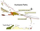
The San Ciprian Hurricane took an unusual east to west path across Puerto Rico
, producing damage across the entire length of the United States territory
. The next storm to produce a similar path was Hurricane Georges
in 1998. Overall damage in Puerto Rico
was catastrophic as the storm left $30 million dollars (1932 USD, $443 million 2006 USD) and 225-257 fatalities. The hurricane also caused moderate damage in the Virgin Islands
.
, the San Ciprian storm was detected by ships as a tropical storm on September 25. A strong high pressure system to the north kept the storm moving due west. It reached hurricane strength hours later as it passed the islands of Antigua
and St. Barthelemy at 3 p.m. On September 26, the hurricane passed through the rest of the Leeward Islands
as it gained strength. During its journey, the hurricane quickly strengthened to Category 3 status and its winds peaked at 120 mph (195 km/h). At 10 p.m., the hurricane made landfall near Ceiba
, with the eye
passing directly over the Ensenada Honda harbor. After striking Puerto Rico
, the storm continued westward where it made its second landfall near Santo Domingo
on September 27. The storm weakened as it crossed into Haiti
as a tropical storm. After impacting Hispaniola
, the storm continued westward where it brushed past Jamaica
to the south. On October 1, the tropical storm made landfall in Belize
(then known as British Honduras) and crossed over the Yucatan Peninsula
before making its final landfall near Veracruz
, Mexico
. It dissipated on October 3.
 Forecasters at the United States Weather Bureau issued tropical cyclone watches and warnings for the islands of St. Kitts and Nevis and St. Martin.
In Puerto Rico
, forecasters began to issue warnings on September 26, and police
and municipality leaders were notified of the storm's approach. The Governor of Puerto Rico
called an emergency meeting with the territories' police chief, the general of the National Guard, Commissioner of Health, and other officials to discuss the preparation for the storm and what actions must be taken after the storm passes. The warnings prompted residents to board up their windows and take precautions.
In the Dominican Republic
, the hurricane's approach triggered fears of a second disaster as that country was still recovering from the destruction by the 1930 Dominican Republic Hurricane
two years earlier. The concern prompted residents to close businesses and evacuate; some sought to nearby churches for shelter. In Jamaica
, meteorologists forecast the storm to move north of the island after passing over Port-au-Prince
, Haiti
. The track of the storm prompted the forecasters to issue advisories for ocean going ships and small watercraft. The countries of Honduras
and Belize
also took preparations ahead of the storm as people closed shops and other businesses in anticipation of the storm's landfall.
(including San Juan
) has seen since the 1928 Okeechobee Hurricane
. Damage from the 1932 hurricane also occurred in areas that escaped damage from the 1928 storm. Damage from the 1932 hurricane affected 49 municipalities in Puerto Rico
.
reported 60 mph (97 km/h) winds and barometric pressures ranging from 1000 to 1001 mbar
(29.52 to 29.55 inHg). The storm caused moderate damage in the Virgin Islands
as heavy seas sank or heavily damaged small boats and ships in St. Thomas
. The New York Times reported that the hurricane killed 15 people in the Virgin Islands
.
, the hurricane produced heavy rainfall and two ships reported barometric pressures of 938 to 948 mbar (27.70 to 27.99 inHg). A weather station reported winds of 66 mph (106 km/h) and increasing velocities before the station was blown down by the storm. As the hurricane passed Puerto Rico
, a weather station in San Juan reported a barometric pressure reading of 980 mbar (28.93 inHg) during the height of the storm.
Offshore, the rough seas brought by the hurricane caused heavy damage to shipping as the storm surge
caused two boats to run aground near Ceiba
. In San Juan, two more boats sustained severe damage. The storm surge and high winds also damaged or destroyed several warehouses. Elsewhere in Puerto Rico
, the damage was even more severe as the hurricane's high winds destroyed many homes in outlying villages killing 109 people. The highest death toll came from the town of Rio Piedras
which was directly in the path of the hurricane and many of the homes were in poor condition to withstand the hurricane's winds. Damage to roads, power lines, and roads disrupted communications and access to the interior portion of Puerto Rico
. Heavy rainfall from the hurricane caused significant flooding that left many homes and buildings under 1.5 feet (0.4 meter) of water.
Agricultural damage from the hurricane was severe as the storm damaged or destroyed much of the citrus, sugar
, coffee
, tobacco
, and honey
harvests. Overall crop damage totaled up to $20 million dollars (1932 USD). In addition, over 400,000 livestock perished in the storm leaving $470,837 dollars (1932 USD) in lost value. Overall, the hurricane killed 257 people, 4,280 more injured and 70-500 thousand homeless. Total storm damage amounted to $30 million dollars (1932 USD, $443 million 2006 USD)
, a weather station in San Pedro de Macoris
reported winds of 90 mph (145 km/h) while another weather station in Santo Domingo
reported winds of 50 mph (80 km/h). Damage in the Dominican Republic was limited to crops and there were no fatalities. The storm then continued on to affect Haiti
, Belize
and Mexico
as a weak tropical storm. Damage in those countries if any was unknown.
, officials and the Red Cross provided $25,000 dollars (1932 USD) in relief aid.
In Puerto Rico
, soon after the disaster, the United States National Guard
was sent to help injured and homeless residents in the storm affected areas. The American Red Cross
also help in distributing food, medical equipment. On September 27,Secretary Woodfin L. Butte surveyed the damage from an airplane to determine which towns sustained most damage from the hurricane. On the same day a local officials set up several relief committees to help continue the relief effort, these committees raised $74,998 (1932 USD) in relief aid. President Herbert Hoover
sent his condolences to the Governor Beverley after the storm. WKAQ
, Puerto Rico's radio station began broadcasting radio addresses by Governor Beverley encouraging residents to continue the hurricane clean up and relief effort. In the overall relief effort, $164,000 dollars (1932 USD) in hurricane relief aid was spent.
Tropical cyclone
A tropical cyclone is a storm system characterized by a large low-pressure center and numerous thunderstorms that produce strong winds and heavy rain. Tropical cyclones strengthen when water evaporated from the ocean is released as the saturated air rises, resulting in condensation of water vapor...
that struck Puerto Rico
Puerto Rico
Puerto Rico , officially the Commonwealth of Puerto Rico , is an unincorporated territory of the United States, located in the northeastern Caribbean, east of the Dominican Republic and west of both the United States Virgin Islands and the British Virgin Islands.Puerto Rico comprises an...
during the 1932 Atlantic hurricane season
1932 Atlantic hurricane season
The 1932 Atlantic hurricane season ran through the summer and the first half of fall in 1932. The 1932 season was an active one. An early tropical storm formed in May and hit Hispaniola, causing minimal damage. A Category 4 struck Galveston, Texas and the Galveston Seawall proved its worth. A...
. The seventh tropical cyclone, fourth hurricane and third major hurricane of the 1932 season, the San Ciprian Hurricane formed on September 25 east of the Leeward Islands
Leeward Islands
The Leeward Islands are a group of islands in the West Indies. They are the northern islands of the Lesser Antilles chain. As a group they start east of Puerto Rico and reach southward to Dominica. They are situated where the northeastern Caribbean Sea meets the western Atlantic Ocean...
and moved due west where it quickly gained hurricane strength a day later. After peaking as a Category 3 storm
Saffir-Simpson Hurricane Scale
The Saffir–Simpson Hurricane Scale , or the Saffir–Simpson Hurricane Wind Scale , classifies hurricanes — Western Hemisphere tropical cyclones that exceed the intensities of tropical depressions and tropical storms — into five categories distinguished by the intensities of their sustained winds...
, the hurricane crossed the entire length of Puerto Rico
Puerto Rico
Puerto Rico , officially the Commonwealth of Puerto Rico , is an unincorporated territory of the United States, located in the northeastern Caribbean, east of the Dominican Republic and west of both the United States Virgin Islands and the British Virgin Islands.Puerto Rico comprises an...
at Category 2 strength. The hurricane later struck the Dominican Republic
Dominican Republic
The Dominican Republic is a nation on the island of La Hispaniola, part of the Greater Antilles archipelago in the Caribbean region. The western third of the island is occupied by the nation of Haiti, making Hispaniola one of two Caribbean islands that are shared by two countries...
as a Category 1 storm. Weakened by its three landfalls, the storm continued to trek westward as a weak tropical storm before making its fourth and fifth landfalls in Belize
Belize
Belize is a constitutional monarchy and the northernmost country in Central America. Belize has a diverse society, comprising many cultures and languages. Even though Kriol and Spanish are spoken among the population, Belize is the only country in Central America where English is the official...
and mainland Mexico
Mexico
The United Mexican States , commonly known as Mexico , is a federal constitutional republic in North America. It is bordered on the north by the United States; on the south and west by the Pacific Ocean; on the southeast by Guatemala, Belize, and the Caribbean Sea; and on the east by the Gulf of...
. The storm then dissipated on October 3.
The San Ciprian Hurricane took an unusual east to west path across Puerto Rico
Puerto Rico
Puerto Rico , officially the Commonwealth of Puerto Rico , is an unincorporated territory of the United States, located in the northeastern Caribbean, east of the Dominican Republic and west of both the United States Virgin Islands and the British Virgin Islands.Puerto Rico comprises an...
, producing damage across the entire length of the United States territory
United States territory
United States territory is any extent of region under the jurisdiction of the federal government of the United States, including all waters including all U.S. Naval carriers. The United States has traditionally proclaimed the sovereign rights for exploring, exploiting, conserving, and managing its...
. The next storm to produce a similar path was Hurricane Georges
Hurricane Georges
Hurricane Georges was a very destructive, powerful and long-lived Cape Verde-type Category 4 hurricane. Georges was the seventh tropical storm, fourth hurricane, and second major hurricane of the 1998 Atlantic hurricane season...
in 1998. Overall damage in Puerto Rico
Puerto Rico
Puerto Rico , officially the Commonwealth of Puerto Rico , is an unincorporated territory of the United States, located in the northeastern Caribbean, east of the Dominican Republic and west of both the United States Virgin Islands and the British Virgin Islands.Puerto Rico comprises an...
was catastrophic as the storm left $30 million dollars (1932 USD, $443 million 2006 USD) and 225-257 fatalities. The hurricane also caused moderate damage in the Virgin Islands
Virgin Islands
The Virgin Islands are the western island group of the Leeward Islands, which are the northern part of the Lesser Antilles, which form the border between the Caribbean Sea and the Atlantic Ocean...
.
Meteorological history
A possible Cape Verde-type hurricaneTropical cyclone
A tropical cyclone is a storm system characterized by a large low-pressure center and numerous thunderstorms that produce strong winds and heavy rain. Tropical cyclones strengthen when water evaporated from the ocean is released as the saturated air rises, resulting in condensation of water vapor...
, the San Ciprian storm was detected by ships as a tropical storm on September 25. A strong high pressure system to the north kept the storm moving due west. It reached hurricane strength hours later as it passed the islands of Antigua
Antigua
Antigua , also known as Waladli, is an island in the West Indies, in the Leeward Islands in the Caribbean region, the main island of the country of Antigua and Barbuda. Antigua means "ancient" in Spanish and was named by Christopher Columbus after an icon in Seville Cathedral, Santa Maria de la...
and St. Barthelemy at 3 p.m. On September 26, the hurricane passed through the rest of the Leeward Islands
Leeward Islands
The Leeward Islands are a group of islands in the West Indies. They are the northern islands of the Lesser Antilles chain. As a group they start east of Puerto Rico and reach southward to Dominica. They are situated where the northeastern Caribbean Sea meets the western Atlantic Ocean...
as it gained strength. During its journey, the hurricane quickly strengthened to Category 3 status and its winds peaked at 120 mph (195 km/h). At 10 p.m., the hurricane made landfall near Ceiba
Ceiba, Puerto Rico
Ceiba is a small town in northeast Puerto Rico. It is named after the famous Ceiba tree. Ceiba is located in the east coast of the island, bordering the Atlantic Ocean, north of Naguabo, south of Fajardo, and east of Río Grande. It is located about one hour's driving distance from San Juan...
, with the eye
Eye (cyclone)
The eye is a region of mostly calm weather found at the center of strong tropical cyclones. The eye of a storm is a roughly circular area and typically 30–65 km in diameter. It is surrounded by the eyewall, a ring of towering thunderstorms where the second most severe weather of a cyclone...
passing directly over the Ensenada Honda harbor. After striking Puerto Rico
Puerto Rico
Puerto Rico , officially the Commonwealth of Puerto Rico , is an unincorporated territory of the United States, located in the northeastern Caribbean, east of the Dominican Republic and west of both the United States Virgin Islands and the British Virgin Islands.Puerto Rico comprises an...
, the storm continued westward where it made its second landfall near Santo Domingo
Santo Domingo
Santo Domingo, known officially as Santo Domingo de Guzmán, is the capital and largest city in the Dominican Republic. Its metropolitan population was 2,084,852 in 2003, and estimated at 3,294,385 in 2010. The city is located on the Caribbean Sea, at the mouth of the Ozama River...
on September 27. The storm weakened as it crossed into Haiti
Haiti
Haiti , officially the Republic of Haiti , is a Caribbean country. It occupies the western, smaller portion of the island of Hispaniola, in the Greater Antillean archipelago, which it shares with the Dominican Republic. Ayiti was the indigenous Taíno or Amerindian name for the island...
as a tropical storm. After impacting Hispaniola
Hispaniola
Hispaniola is a major island in the Caribbean, containing the two sovereign states of the Dominican Republic and Haiti. The island is located between the islands of Cuba to the west and Puerto Rico to the east, within the hurricane belt...
, the storm continued westward where it brushed past Jamaica
Jamaica
Jamaica is an island nation of the Greater Antilles, in length, up to in width and 10,990 square kilometres in area. It is situated in the Caribbean Sea, about south of Cuba, and west of Hispaniola, the island harbouring the nation-states Haiti and the Dominican Republic...
to the south. On October 1, the tropical storm made landfall in Belize
Belize
Belize is a constitutional monarchy and the northernmost country in Central America. Belize has a diverse society, comprising many cultures and languages. Even though Kriol and Spanish are spoken among the population, Belize is the only country in Central America where English is the official...
(then known as British Honduras) and crossed over the Yucatan Peninsula
Yucatán Peninsula
The Yucatán Peninsula, in southeastern Mexico, separates the Caribbean Sea from the Gulf of Mexico, with the northern coastline on the Yucatán Channel...
before making its final landfall near Veracruz
Veracruz, Veracruz
Veracruz, officially known as Heroica Veracruz, is a major port city and municipality on the Gulf of Mexico in the Mexican state of Veracruz. The city is located in the central part of the state. It is located along Federal Highway 140 from the state capital Xalapa, and is the state's most...
, Mexico
Mexico
The United Mexican States , commonly known as Mexico , is a federal constitutional republic in North America. It is bordered on the north by the United States; on the south and west by the Pacific Ocean; on the southeast by Guatemala, Belize, and the Caribbean Sea; and on the east by the Gulf of...
. It dissipated on October 3.
Preparations
In Puerto Rico
Puerto Rico
Puerto Rico , officially the Commonwealth of Puerto Rico , is an unincorporated territory of the United States, located in the northeastern Caribbean, east of the Dominican Republic and west of both the United States Virgin Islands and the British Virgin Islands.Puerto Rico comprises an...
, forecasters began to issue warnings on September 26, and police
Police
The police is a personification of the state designated to put in practice the enforced law, protect property and reduce civil disorder in civilian matters. Their powers include the legitimized use of force...
and municipality leaders were notified of the storm's approach. The Governor of Puerto Rico
Puerto Rico
Puerto Rico , officially the Commonwealth of Puerto Rico , is an unincorporated territory of the United States, located in the northeastern Caribbean, east of the Dominican Republic and west of both the United States Virgin Islands and the British Virgin Islands.Puerto Rico comprises an...
called an emergency meeting with the territories' police chief, the general of the National Guard, Commissioner of Health, and other officials to discuss the preparation for the storm and what actions must be taken after the storm passes. The warnings prompted residents to board up their windows and take precautions.
In the Dominican Republic
Dominican Republic
The Dominican Republic is a nation on the island of La Hispaniola, part of the Greater Antilles archipelago in the Caribbean region. The western third of the island is occupied by the nation of Haiti, making Hispaniola one of two Caribbean islands that are shared by two countries...
, the hurricane's approach triggered fears of a second disaster as that country was still recovering from the destruction by the 1930 Dominican Republic Hurricane
1930 Dominican Republic Hurricane
The 1930 Dominican Republic Hurricane, also known as Hurricane San Zenon, is the fifth deadliest Atlantic hurricane on record. The second of two known tropical cyclones in the 1930 Atlantic hurricane season, the hurricane was first observed on August 29 to the east of the Lesser Antilles...
two years earlier. The concern prompted residents to close businesses and evacuate; some sought to nearby churches for shelter. In Jamaica
Jamaica
Jamaica is an island nation of the Greater Antilles, in length, up to in width and 10,990 square kilometres in area. It is situated in the Caribbean Sea, about south of Cuba, and west of Hispaniola, the island harbouring the nation-states Haiti and the Dominican Republic...
, meteorologists forecast the storm to move north of the island after passing over Port-au-Prince
Port-au-Prince
Port-au-Prince is the capital and largest city of the Caribbean nation of Haiti. The city's population was 704,776 as of the 2003 census, and was officially estimated to have reached 897,859 in 2009....
, Haiti
Haiti
Haiti , officially the Republic of Haiti , is a Caribbean country. It occupies the western, smaller portion of the island of Hispaniola, in the Greater Antillean archipelago, which it shares with the Dominican Republic. Ayiti was the indigenous Taíno or Amerindian name for the island...
. The track of the storm prompted the forecasters to issue advisories for ocean going ships and small watercraft. The countries of Honduras
Honduras
Honduras is a republic in Central America. It was previously known as Spanish Honduras to differentiate it from British Honduras, which became the modern-day state of Belize...
and Belize
Belize
Belize is a constitutional monarchy and the northernmost country in Central America. Belize has a diverse society, comprising many cultures and languages. Even though Kriol and Spanish are spoken among the population, Belize is the only country in Central America where English is the official...
also took preparations ahead of the storm as people closed shops and other businesses in anticipation of the storm's landfall.
Impact
The impact of the San Ciprian Hurricane was the worst Puerto RicoPuerto Rico
Puerto Rico , officially the Commonwealth of Puerto Rico , is an unincorporated territory of the United States, located in the northeastern Caribbean, east of the Dominican Republic and west of both the United States Virgin Islands and the British Virgin Islands.Puerto Rico comprises an...
(including San Juan
San Juan, Puerto Rico
San Juan , officially Municipio de la Ciudad Capital San Juan Bautista , is the capital and most populous municipality in Puerto Rico, an unincorporated territory of the United States. As of the 2010 census, it had a population of 395,326 making it the 46th-largest city under the jurisdiction of...
) has seen since the 1928 Okeechobee Hurricane
1928 Okeechobee Hurricane
The Okeechobee hurricane, or San Felipe Segundo hurricane, was a deadly hurricane that struck the Leeward Islands, Puerto Rico, the Bahamas, and Florida in September of the 1928 Atlantic hurricane season...
. Damage from the 1932 hurricane also occurred in areas that escaped damage from the 1928 storm. Damage from the 1932 hurricane affected 49 municipalities in Puerto Rico
Puerto Rico
Puerto Rico , officially the Commonwealth of Puerto Rico , is an unincorporated territory of the United States, located in the northeastern Caribbean, east of the Dominican Republic and west of both the United States Virgin Islands and the British Virgin Islands.Puerto Rico comprises an...
.
Virgin Islands
Weather stations in St. Croix and St. ThomasSaint Thomas, U.S. Virgin Islands
Saint Thomas is an island in the Caribbean Sea and with the islands of Saint John, Saint Croix, and Water Island a county and constituent district of the United States Virgin Islands , an unincorporated territory of the United States. Located on the island is the territorial capital and port of...
reported 60 mph (97 km/h) winds and barometric pressures ranging from 1000 to 1001 mbar
Bar (unit)
The bar is a unit of pressure equal to 100 kilopascals, and roughly equal to the atmospheric pressure on Earth at sea level. Other units derived from the bar are the megabar , kilobar , decibar , centibar , and millibar...
(29.52 to 29.55 inHg). The storm caused moderate damage in the Virgin Islands
Virgin Islands
The Virgin Islands are the western island group of the Leeward Islands, which are the northern part of the Lesser Antilles, which form the border between the Caribbean Sea and the Atlantic Ocean...
as heavy seas sank or heavily damaged small boats and ships in St. Thomas
Saint Thomas, U.S. Virgin Islands
Saint Thomas is an island in the Caribbean Sea and with the islands of Saint John, Saint Croix, and Water Island a county and constituent district of the United States Virgin Islands , an unincorporated territory of the United States. Located on the island is the territorial capital and port of...
. The New York Times reported that the hurricane killed 15 people in the Virgin Islands
Virgin Islands
The Virgin Islands are the western island group of the Leeward Islands, which are the northern part of the Lesser Antilles, which form the border between the Caribbean Sea and the Atlantic Ocean...
.
Puerto Rico
In Puerto RicoPuerto Rico
Puerto Rico , officially the Commonwealth of Puerto Rico , is an unincorporated territory of the United States, located in the northeastern Caribbean, east of the Dominican Republic and west of both the United States Virgin Islands and the British Virgin Islands.Puerto Rico comprises an...
, the hurricane produced heavy rainfall and two ships reported barometric pressures of 938 to 948 mbar (27.70 to 27.99 inHg). A weather station reported winds of 66 mph (106 km/h) and increasing velocities before the station was blown down by the storm. As the hurricane passed Puerto Rico
Puerto Rico
Puerto Rico , officially the Commonwealth of Puerto Rico , is an unincorporated territory of the United States, located in the northeastern Caribbean, east of the Dominican Republic and west of both the United States Virgin Islands and the British Virgin Islands.Puerto Rico comprises an...
, a weather station in San Juan reported a barometric pressure reading of 980 mbar (28.93 inHg) during the height of the storm.
Offshore, the rough seas brought by the hurricane caused heavy damage to shipping as the storm surge
Storm surge
A storm surge is an offshore rise of water associated with a low pressure weather system, typically tropical cyclones and strong extratropical cyclones. Storm surges are caused primarily by high winds pushing on the ocean's surface. The wind causes the water to pile up higher than the ordinary sea...
caused two boats to run aground near Ceiba
Ceiba, Puerto Rico
Ceiba is a small town in northeast Puerto Rico. It is named after the famous Ceiba tree. Ceiba is located in the east coast of the island, bordering the Atlantic Ocean, north of Naguabo, south of Fajardo, and east of Río Grande. It is located about one hour's driving distance from San Juan...
. In San Juan, two more boats sustained severe damage. The storm surge and high winds also damaged or destroyed several warehouses. Elsewhere in Puerto Rico
Puerto Rico
Puerto Rico , officially the Commonwealth of Puerto Rico , is an unincorporated territory of the United States, located in the northeastern Caribbean, east of the Dominican Republic and west of both the United States Virgin Islands and the British Virgin Islands.Puerto Rico comprises an...
, the damage was even more severe as the hurricane's high winds destroyed many homes in outlying villages killing 109 people. The highest death toll came from the town of Rio Piedras
Río Piedras, Puerto Rico
Río Piedras is a district of San Juan, Puerto Rico. Founded in 1714, it has been the home of the University of Puerto Rico's main campus since 1903, earning the town the popular name of Ciudad Universitaria...
which was directly in the path of the hurricane and many of the homes were in poor condition to withstand the hurricane's winds. Damage to roads, power lines, and roads disrupted communications and access to the interior portion of Puerto Rico
Puerto Rico
Puerto Rico , officially the Commonwealth of Puerto Rico , is an unincorporated territory of the United States, located in the northeastern Caribbean, east of the Dominican Republic and west of both the United States Virgin Islands and the British Virgin Islands.Puerto Rico comprises an...
. Heavy rainfall from the hurricane caused significant flooding that left many homes and buildings under 1.5 feet (0.4 meter) of water.
Agricultural damage from the hurricane was severe as the storm damaged or destroyed much of the citrus, sugar
Sugar
Sugar is a class of edible crystalline carbohydrates, mainly sucrose, lactose, and fructose, characterized by a sweet flavor.Sucrose in its refined form primarily comes from sugar cane and sugar beet...
, coffee
Coffee
Coffee is a brewed beverage with a dark,init brooo acidic flavor prepared from the roasted seeds of the coffee plant, colloquially called coffee beans. The beans are found in coffee cherries, which grow on trees cultivated in over 70 countries, primarily in equatorial Latin America, Southeast Asia,...
, tobacco
Tobacco
Tobacco is an agricultural product processed from the leaves of plants in the genus Nicotiana. It can be consumed, used as a pesticide and, in the form of nicotine tartrate, used in some medicines...
, and honey
Honey
Honey is a sweet food made by bees using nectar from flowers. The variety produced by honey bees is the one most commonly referred to and is the type of honey collected by beekeepers and consumed by humans...
harvests. Overall crop damage totaled up to $20 million dollars (1932 USD). In addition, over 400,000 livestock perished in the storm leaving $470,837 dollars (1932 USD) in lost value. Overall, the hurricane killed 257 people, 4,280 more injured and 70-500 thousand homeless. Total storm damage amounted to $30 million dollars (1932 USD, $443 million 2006 USD)
Caribbean Sea and Mexico
In the Dominican RepublicDominican Republic
The Dominican Republic is a nation on the island of La Hispaniola, part of the Greater Antilles archipelago in the Caribbean region. The western third of the island is occupied by the nation of Haiti, making Hispaniola one of two Caribbean islands that are shared by two countries...
, a weather station in San Pedro de Macoris
San Pedro de Macorís
San Pedro de Macorís is a municipality and the capital of the San Pedro de Macorís province in the Dominican Republic.-Demographics:...
reported winds of 90 mph (145 km/h) while another weather station in Santo Domingo
Santo Domingo
Santo Domingo, known officially as Santo Domingo de Guzmán, is the capital and largest city in the Dominican Republic. Its metropolitan population was 2,084,852 in 2003, and estimated at 3,294,385 in 2010. The city is located on the Caribbean Sea, at the mouth of the Ozama River...
reported winds of 50 mph (80 km/h). Damage in the Dominican Republic was limited to crops and there were no fatalities. The storm then continued on to affect Haiti
Haiti
Haiti , officially the Republic of Haiti , is a Caribbean country. It occupies the western, smaller portion of the island of Hispaniola, in the Greater Antillean archipelago, which it shares with the Dominican Republic. Ayiti was the indigenous Taíno or Amerindian name for the island...
, Belize
Belize
Belize is a constitutional monarchy and the northernmost country in Central America. Belize has a diverse society, comprising many cultures and languages. Even though Kriol and Spanish are spoken among the population, Belize is the only country in Central America where English is the official...
and Mexico
Mexico
The United Mexican States , commonly known as Mexico , is a federal constitutional republic in North America. It is bordered on the north by the United States; on the south and west by the Pacific Ocean; on the southeast by Guatemala, Belize, and the Caribbean Sea; and on the east by the Gulf of...
as a weak tropical storm. Damage in those countries if any was unknown.
Aftermath
In the Virgin IslandsVirgin Islands
The Virgin Islands are the western island group of the Leeward Islands, which are the northern part of the Lesser Antilles, which form the border between the Caribbean Sea and the Atlantic Ocean...
, officials and the Red Cross provided $25,000 dollars (1932 USD) in relief aid.
In Puerto Rico
Puerto Rico
Puerto Rico , officially the Commonwealth of Puerto Rico , is an unincorporated territory of the United States, located in the northeastern Caribbean, east of the Dominican Republic and west of both the United States Virgin Islands and the British Virgin Islands.Puerto Rico comprises an...
, soon after the disaster, the United States National Guard
United States National Guard
The National Guard of the United States is a reserve military force composed of state National Guard militia members or units under federally recognized active or inactive armed force service for the United States. Militia members are citizen soldiers, meaning they work part time for the National...
was sent to help injured and homeless residents in the storm affected areas. The American Red Cross
American Red Cross
The American Red Cross , also known as the American National Red Cross, is a volunteer-led, humanitarian organization that provides emergency assistance, disaster relief and education inside the United States. It is the designated U.S...
also help in distributing food, medical equipment. On September 27,Secretary Woodfin L. Butte surveyed the damage from an airplane to determine which towns sustained most damage from the hurricane. On the same day a local officials set up several relief committees to help continue the relief effort, these committees raised $74,998 (1932 USD) in relief aid. President Herbert Hoover
Herbert Hoover
Herbert Clark Hoover was the 31st President of the United States . Hoover was originally a professional mining engineer and author. As the United States Secretary of Commerce in the 1920s under Presidents Warren Harding and Calvin Coolidge, he promoted partnerships between government and business...
sent his condolences to the Governor Beverley after the storm. WKAQ
WKAQ (AM)
WKAQ is a radio station in San Juan, Puerto Rico that broadcasts on 580 kHz with a Spanish language talk radio format. The station is currently owned by Univision Radio. Its programming is repeated on WUKQ, which broadcasts on 1420 kHz in Ponce, and WYEL which broadcasts on 600 kHz in Mayagüez...
, Puerto Rico's radio station began broadcasting radio addresses by Governor Beverley encouraging residents to continue the hurricane clean up and relief effort. In the overall relief effort, $164,000 dollars (1932 USD) in hurricane relief aid was spent.