
1891 Atlantic hurricane season
Encyclopedia
The 1891 Atlantic hurricane season ran through the summer and the first half of fall in 1891. The season had 10 tropical storms, 7 of which became hurricanes. However, due to scarce technology and the fact that only storms that affected land or ships were recorded, the actual total could be higher.
northwest of Campeche
; made landfall near Galveston, Texas
; dissipated near the Alabama
-Tennessee
state line.
Islands; dissipated in the Atlantic Ocean
; made landfalls in the Dominican Republic
, Bahamas and Florida
; dissipated in the Gulf of Mexico
; made landfalls in Nova Scotia
and Newfoundland; dissipated north of Newfoundland in the Labrador Sea
as a Category 1 system and dissipated west-northwest of Madeira
and Newfoundland less than a month after Hurricane Four affected the area; dissipated in the Labrador Sea
south of Jamaica
; made landfalls on Isla de la Juventud, and in Cuba
and Florida
; dissipated in the open Atlantic
; made landfalls in Cuba
, Florida
, Nova Scotia
and Newfoundland; dissipated west-southwest of Iceland
, and made landfalls on Saint Croix and the main Virgin Islands
; dissipated just before affecting southern tip of Nova Scotia
, Bahamas; never made landfall before dissipating in the open Atlantic.
Storms
| Storm | Formed | Dissipated | Max. Winds |
|---|---|---|---|
| July 3 | July 8 | 90 mph | |
| August 17 | August 29 | 75 mph | |
| August 18 | August 25 | 125 mph | |
| September 2 | September 10 | 100 mph | |
| September 16 | September 26 | 100 mph | |
| September 29 | October 8 | 100 mph | |
| October 4 | October 10 | 50 mph | |
| October 7 | October 16 | 65 mph | |
| October 12 | October 20 | 85 mph | |
| November 3 | November 6 | 60 mph |
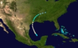
Hurricane One
Formed in Gulf of MexicoGulf of Mexico
The Gulf of Mexico is a partially landlocked ocean basin largely surrounded by the North American continent and the island of Cuba. It is bounded on the northeast, north and northwest by the Gulf Coast of the United States, on the southwest and south by Mexico, and on the southeast by Cuba. In...
northwest of Campeche
Campeche, Campeche
San Francisco de Campeche is the capital city of the Mexican state of Campeche, located at,...
; made landfall near Galveston, Texas
Texas
Texas is the second largest U.S. state by both area and population, and the largest state by area in the contiguous United States.The name, based on the Caddo word "Tejas" meaning "friends" or "allies", was applied by the Spanish to the Caddo themselves and to the region of their settlement in...
; dissipated near the Alabama
Alabama
Alabama is a state located in the southeastern region of the United States. It is bordered by Tennessee to the north, Georgia to the east, Florida and the Gulf of Mexico to the south, and Mississippi to the west. Alabama ranks 30th in total land area and ranks second in the size of its inland...
-Tennessee
Tennessee
Tennessee is a U.S. state located in the Southeastern United States. It has a population of 6,346,105, making it the nation's 17th-largest state by population, and covers , making it the 36th-largest by total land area...
state line.
Hurricane Two
Formed south of the Cape VerdeCape Verde
The Republic of Cape Verde is an island country, spanning an archipelago of 10 islands located in the central Atlantic Ocean, 570 kilometres off the coast of Western Africa...
Islands; dissipated in the Atlantic Ocean
Atlantic Ocean
The Atlantic Ocean is the second-largest of the world's oceanic divisions. With a total area of about , it covers approximately 20% of the Earth's surface and about 26% of its water surface area...
Hurricane Three
Formed east of the Lesser AntillesLesser Antilles
The Lesser Antilles are a long, partly volcanic island arc in the Western Hemisphere. Most of its islands form the eastern boundary of the Caribbean Sea with the Atlantic Ocean, with the remainder located in the southern Caribbean just north of South America...
; made landfalls in the Dominican Republic
Dominican Republic
The Dominican Republic is a nation on the island of La Hispaniola, part of the Greater Antilles archipelago in the Caribbean region. The western third of the island is occupied by the nation of Haiti, making Hispaniola one of two Caribbean islands that are shared by two countries...
, Bahamas and Florida
Florida
Florida is a state in the southeastern United States, located on the nation's Atlantic and Gulf coasts. It is bordered to the west by the Gulf of Mexico, to the north by Alabama and Georgia and to the east by the Atlantic Ocean. With a population of 18,801,310 as measured by the 2010 census, it...
; dissipated in the Gulf of Mexico
Hurricane Four
Formed northeast of the Leeward IslandsLeeward Islands
The Leeward Islands are a group of islands in the West Indies. They are the northern islands of the Lesser Antilles chain. As a group they start east of Puerto Rico and reach southward to Dominica. They are situated where the northeastern Caribbean Sea meets the western Atlantic Ocean...
; made landfalls in Nova Scotia
Nova Scotia
Nova Scotia is one of Canada's three Maritime provinces and is the most populous province in Atlantic Canada. The name of the province is Latin for "New Scotland," but "Nova Scotia" is the recognized, English-language name of the province. The provincial capital is Halifax. Nova Scotia is the...
and Newfoundland; dissipated north of Newfoundland in the Labrador Sea
Labrador Sea
The Labrador Sea is an arm of the North Atlantic Ocean between the Labrador Peninsula and Greenland. The sea is flanked by continental shelves to the southwest, northwest, and northeast. It connects to the north with Baffin Bay through the Davis Strait...
Hurricane Five
Formed in the open Atlantic near 20°N 45°W; a fish-spinning storm that threatened BermudaBermuda
Bermuda is a British overseas territory in the North Atlantic Ocean. Located off the east coast of the United States, its nearest landmass is Cape Hatteras, North Carolina, about to the west-northwest. It is about south of Halifax, Nova Scotia, Canada, and northeast of Miami, Florida...
as a Category 1 system and dissipated west-northwest of Madeira
Hurricane Six
Formed in the open Atlantic near 21°N 52°W; threatened Bermuda and made landfalls in Nova ScotiaNova Scotia
Nova Scotia is one of Canada's three Maritime provinces and is the most populous province in Atlantic Canada. The name of the province is Latin for "New Scotland," but "Nova Scotia" is the recognized, English-language name of the province. The provincial capital is Halifax. Nova Scotia is the...
and Newfoundland less than a month after Hurricane Four affected the area; dissipated in the Labrador Sea
Tropical Storm Seven
Formed in the Caribbean SeaCaribbean Sea
The Caribbean Sea is a sea of the Atlantic Ocean located in the tropics of the Western hemisphere. It is bounded by Mexico and Central America to the west and southwest, to the north by the Greater Antilles, and to the east by the Lesser Antilles....
south of Jamaica
Jamaica
Jamaica is an island nation of the Greater Antilles, in length, up to in width and 10,990 square kilometres in area. It is situated in the Caribbean Sea, about south of Cuba, and west of Hispaniola, the island harbouring the nation-states Haiti and the Dominican Republic...
; made landfalls on Isla de la Juventud, and in Cuba
Cuba
The Republic of Cuba is an island nation in the Caribbean. The nation of Cuba consists of the main island of Cuba, the Isla de la Juventud, and several archipelagos. Havana is the largest city in Cuba and the country's capital. Santiago de Cuba is the second largest city...
and Florida
Florida
Florida is a state in the southeastern United States, located on the nation's Atlantic and Gulf coasts. It is bordered to the west by the Gulf of Mexico, to the north by Alabama and Georgia and to the east by the Atlantic Ocean. With a population of 18,801,310 as measured by the 2010 census, it...
; dissipated in the open Atlantic
Tropical Storm Eight
Formed north of HondurasHonduras
Honduras is a republic in Central America. It was previously known as Spanish Honduras to differentiate it from British Honduras, which became the modern-day state of Belize...
; made landfalls in Cuba
Cuba
The Republic of Cuba is an island nation in the Caribbean. The nation of Cuba consists of the main island of Cuba, the Isla de la Juventud, and several archipelagos. Havana is the largest city in Cuba and the country's capital. Santiago de Cuba is the second largest city...
, Florida
Florida
Florida is a state in the southeastern United States, located on the nation's Atlantic and Gulf coasts. It is bordered to the west by the Gulf of Mexico, to the north by Alabama and Georgia and to the east by the Atlantic Ocean. With a population of 18,801,310 as measured by the 2010 census, it...
, Nova Scotia
Nova Scotia
Nova Scotia is one of Canada's three Maritime provinces and is the most populous province in Atlantic Canada. The name of the province is Latin for "New Scotland," but "Nova Scotia" is the recognized, English-language name of the province. The provincial capital is Halifax. Nova Scotia is the...
and Newfoundland; dissipated west-southwest of Iceland
Iceland
Iceland , described as the Republic of Iceland, is a Nordic and European island country in the North Atlantic Ocean, on the Mid-Atlantic Ridge. Iceland also refers to the main island of the country, which contains almost all the population and almost all the land area. The country has a population...
Hurricane Nine
Formed north of GrenadaGrenada
Grenada is an island country and Commonwealth Realm consisting of the island of Grenada and six smaller islands at the southern end of the Grenadines in the southeastern Caribbean Sea...
, and made landfalls on Saint Croix and the main Virgin Islands
Virgin Islands
The Virgin Islands are the western island group of the Leeward Islands, which are the northern part of the Lesser Antilles, which form the border between the Caribbean Sea and the Atlantic Ocean...
; dissipated just before affecting southern tip of Nova Scotia
Tropical Storm Ten
Formed northeast of present-day NassauNassau, Bahamas
Nassau is the capital, largest city, and commercial centre of the Commonwealth of the Bahamas. The city has a population of 248,948 , 70 percent of the entire population of The Bahamas...
, Bahamas; never made landfall before dissipating in the open Atlantic.
See also
- List of tropical cyclones
- List of Atlantic hurricane seasons