
1840-1849 Atlantic hurricane seasons
Encyclopedia
1820s
1830s
1840s 1850s
1860s
1820-1829 Atlantic hurricane seasons
1800s 1810s 1820s 1830s 1840s-1820 Atlantic hurricane season:I. A minimal hurricane moved from Florida on September 8 northward to hit near the border of North Carolina and South Carolina on September 10. It caused only minor damage.II...
1830s
1830-1839 Atlantic hurricane seasons
1810s 1820s 1830s 1840s 1850s-1830 Atlantic hurricane season:I. A hurricane moved from Trinidad to western Cuba between August 3 and August 9.-Atlantic Coast Hurricane:...
1840s 1850s
1850-1859 Atlantic hurricane seasons
1830s 1840s 1850s 1860s 1870s-1850 Atlantic hurricane season:The first of three hurricanes to affect the upper Eastern Seaboard moved into North Carolina on July 18. As it moved north, Chesapeake Bay and Delaware Bay took a beating as high waves and tides flooded the coast...
1860s
1860-1869 Atlantic hurricane seasons
1840s 1850s 1860s 1870s 1880-84-Tropical Storm Four:While there were 6 storms this season, only one affected any landmass as a tropical system; a tropical storm hitting the Lesser Antilles.-Hurricane Three:...
1840 Atlantic hurricane season
I. On June 19, a tropical storm hit near Lake Charles, LouisianaLake Charles, Louisiana
Lake Charles is the fifth-largest incorporated city in the U.S. state of Louisiana, located on Lake Charles, Prien Lake, and the Calcasieu River. Located in Calcasieu Parish, a major cultural, industrial, and educational center in the southwest region of the state, and one of the most important in...
.
II. A hurricane hit near the mouth of the Rio Grande
Rio Grande
The Rio Grande is a river that flows from southwestern Colorado in the United States to the Gulf of Mexico. Along the way it forms part of the Mexico – United States border. Its length varies as its course changes...
, destroying villages and causing flooding.
1841 Atlantic hurricane season
I. A strong tropical storm hit the FloridaFlorida
Florida is a state in the southeastern United States, located on the nation's Atlantic and Gulf coasts. It is bordered to the west by the Gulf of Mexico, to the north by Alabama and Georgia and to the east by the Atlantic Ocean. With a population of 18,801,310 as measured by the 2010 census, it...
Panhandle on September 14.
II. An intense hurricane remained offshore of the Carolinas in early October. It moved northeastward, entraining cold air into its circulation. It became an extratropical storm, and hit New England
New England
New England is a region in the northeastern corner of the United States consisting of the six states of Maine, New Hampshire, Vermont, Massachusetts, Rhode Island, and Connecticut...
on October 3. It led to a storm of snow and sleet in Connecticut
Connecticut
Connecticut is a state in the New England region of the northeastern United States. It is bordered by Rhode Island to the east, Massachusetts to the north, and the state of New York to the west and the south .Connecticut is named for the Connecticut River, the major U.S. river that approximately...
, bringing drifts of up to 18 feet (5.5 m) of snow in some areas. The storm wrecked the Georges Bank
Georges Bank
Georges Bank is a large elevated area of the sea floor which separates the Gulf of Maine from the Atlantic Ocean and is situated between Cape Cod, Massachusetts and Cape Sable Island, Nova Scotia ....
fishing fleet which drowned 81 fishermen and knocked down trees, tore roofs off houses and forced boats to go up on shore. The storm also destroyed a saltworks factory along Cape Cod
Cape Cod
Cape Cod, often referred to locally as simply the Cape, is a cape in the easternmost portion of the state of Massachusetts, in the Northeastern United States...
, sending the economy to a slump. In 1842, a monument was erected to remember the sailors and fishermen lost at sea to the "October Gale" of 1841.
III. In October, a hurricane hit Cuba
Cuba
The Republic of Cuba is an island nation in the Caribbean. The nation of Cuba consists of the main island of Cuba, the Isla de la Juventud, and several archipelagos. Havana is the largest city in Cuba and the country's capital. Santiago de Cuba is the second largest city...
, crossing near Havana
Havana
Havana is the capital city, province, major port, and leading commercial centre of Cuba. The city proper has a population of 2.1 million inhabitants, and it spans a total of — making it the largest city in the Caribbean region, and the most populous...
. After crossing the island, it passed by the Florida Keys
Florida Keys
The Florida Keys are a coral archipelago in southeast United States. They begin at the southeastern tip of the Florida peninsula, about south of Miami, and extend in a gentle arc south-southwest and then westward to Key West, the westernmost of the inhabited islands, and on to the uninhabited Dry...
, bringing them heavy rain but remaining offshore.
1842 Atlantic hurricane season
I. A major hurricane hit near Portsmouth, North CarolinaPortsmouth, North Carolina
Portsmouth was a fishing and shipping village located on the north end of the Core Banks on the Outer Banks in North Carolina. The site lies on Portsmouth Island in Carteret County, across Ocracoke Inlet from the village of Ocracoke. The town was established in 1753, and abandoned in 1971...
on July 12. Two ships were capsized, killing their entire crews. It continued across Virginia
Virginia
The Commonwealth of Virginia , is a U.S. state on the Atlantic Coast of the Southern United States. Virginia is nicknamed the "Old Dominion" and sometimes the "Mother of Presidents" after the eight U.S. presidents born there...
, dissipating over Maryland
Maryland
Maryland is a U.S. state located in the Mid Atlantic region of the United States, bordering Virginia, West Virginia, and the District of Columbia to its south and west; Pennsylvania to its north; and Delaware to its east...
.
II. On August 2, a tropical storm hit Northeastern Florida
Florida
Florida is a state in the southeastern United States, located on the nation's Atlantic and Gulf coasts. It is bordered to the west by the Gulf of Mexico, to the north by Alabama and Georgia and to the east by the Atlantic Ocean. With a population of 18,801,310 as measured by the 2010 census, it...
.
III. A second North Carolina
North Carolina
North Carolina is a state located in the southeastern United States. The state borders South Carolina and Georgia to the south, Tennessee to the west and Virginia to the north. North Carolina contains 100 counties. Its capital is Raleigh, and its largest city is Charlotte...
hurricane hit Ocracoke, North Carolina
Ocracoke, North Carolina
Ocracoke is a census-designated place and unincorporated town located at the southern end of Ocracoke Island, located entirely within Hyde County, North Carolina. The population was 769 as of the 2000 census...
on August 24, drowning livestock and washing away homes. In addition, it sank three ships, causing at least 8 deaths.
IV. A westward moving hurricane, nicknamed Antje's hurricane after a schooner of the same name that was dismasted by the storm. The cyclone moved across the Florida Keys
Florida Keys
The Florida Keys are a coral archipelago in southeast United States. They begin at the southeastern tip of the Florida peninsula, about south of Miami, and extend in a gentle arc south-southwest and then westward to Key West, the westernmost of the inhabited islands, and on to the uninhabited Dry...
on September 4. It continued westward across the Gulf of Mexico
Gulf of Mexico
The Gulf of Mexico is a partially landlocked ocean basin largely surrounded by the North American continent and the island of Cuba. It is bounded on the northeast, north and northwest by the Gulf Coast of the United States, on the southwest and south by Mexico, and on the southeast by Cuba. In...
, hitting between Matamoros
Matamoros, Tamaulipas
Matamoros, officially known as Heroica Matamoros, is a city in the northeastern part of Tamaulipas, in the country of Mexico. It is located on the southern bank of the Rio Grande, directly across the border from Brownsville, Texas, in the United States. Matamoros is the second largest and second...
and Tampico
Tampico
Tampico is a city and port in the state of Tamaulipas, in the country of Mexico. It is located in the southeastern part of the state, directly north across the border from Veracruz. Tampico is the third largest city in Tamaulipas, and counts with a population of 309,003. The Metropolitan area of...
, Mexico
Mexico
The United Mexican States , commonly known as Mexico , is a federal constitutional republic in North America. It is bordered on the north by the United States; on the south and west by the Pacific Ocean; on the southeast by Guatemala, Belize, and the Caribbean Sea; and on the east by the Gulf of...
. Its unusual westward movement, also seen by a hurricane in 1932 and Hurricane Anita
Hurricane Anita
Hurricane Anita was a powerful Atlantic hurricane during an otherwise quiet 1977 Atlantic hurricane season. The first tropical cyclone of the season, Anita developed from a tropical wave on August 29 in the north-central Gulf of Mexico. It tracked westward into an area with conditions favorable for...
in 1977, was due to a strong high pressure system to its north.
V. A strong tropical storm hit Galveston, Texas
Galveston, Texas
Galveston is a coastal city located on Galveston Island in the U.S. state of Texas. , the city had a total population of 47,743 within an area of...
on September 17. It caused $10,000 in damage, and killed 40 cattle.
VI. A tropical storm hit the Pensacola, Florida
Pensacola, Florida
Pensacola is the westernmost city in the Florida Panhandle and the county seat of Escambia County, Florida, United States of America. As of the 2000 census, the city had a total population of 56,255 and as of 2009, the estimated population was 53,752...
area on September 22.
VII. A hurricane passed by Galveston
Galveston, Texas
Galveston is a coastal city located on Galveston Island in the U.S. state of Texas. , the city had a total population of 47,743 within an area of...
on October 5, causing flooding and the sinking of one ship. It continued eastward, becoming a major hurricane before hitting near St. Marks, Florida
St. Marks, Florida
St. Marks is a city in Wakulla County, Florida, United States. It is part of the Tallahassee, Florida, Metropolitan Statistical Area. The population was 272 at the 2000 census. As of 2004, the population estimated by the U.S. Census Bureau is 299 .-Geography:...
. It caused $500,000 in damage before moving out to sea on the 10th. The storm
Storm
A storm is any disturbed state of an astronomical body's atmosphere, especially affecting its surface, and strongly implying severe weather...
is known as the Gulf to Bermuda Hurricane.
VIII. This cyclone was first detected east of Miami, Florida
Miami, Florida
Miami is a city located on the Atlantic coast in southeastern Florida and the county seat of Miami-Dade County, the most populous county in Florida and the eighth-most populous county in the United States with a population of 2,500,625...
on October 26. It paralleled the coastlines of Florida
Florida
Florida is a state in the southeastern United States, located on the nation's Atlantic and Gulf coasts. It is bordered to the west by the Gulf of Mexico, to the north by Alabama and Georgia and to the east by the Atlantic Ocean. With a population of 18,801,310 as measured by the 2010 census, it...
, Georgia
Georgia (U.S. state)
Georgia is a state located in the southeastern United States. It was established in 1732, the last of the original Thirteen Colonies. The state is named after King George II of Great Britain. Georgia was the fourth state to ratify the United States Constitution, on January 2, 1788...
, and South Carolina
South Carolina
South Carolina is a state in the Deep South of the United States that borders Georgia to the south, North Carolina to the north, and the Atlantic Ocean to the east. Originally part of the Province of Carolina, the Province of South Carolina was one of the 13 colonies that declared independence...
before dissipating on the 30th south of North Carolina
North Carolina
North Carolina is a state located in the southeastern United States. The state borders South Carolina and Georgia to the south, Tennessee to the west and Virginia to the north. North Carolina contains 100 counties. Its capital is Raleigh, and its largest city is Charlotte...
.
IX. A cyclone, first detected southwest of Madeira
Madeira
Madeira is a Portuguese archipelago that lies between and , just under 400 km north of Tenerife, Canary Islands, in the north Atlantic Ocean and an outermost region of the European Union...
on October 24, passed the island on October 26, moving northeast towards the Iberian Peninsula
Iberian Peninsula
The Iberian Peninsula , sometimes called Iberia, is located in the extreme southwest of Europe and includes the modern-day sovereign states of Spain, Portugal and Andorra, as well as the British Overseas Territory of Gibraltar...
. It struck southern Spain
Spain
Spain , officially the Kingdom of Spain languages]] under the European Charter for Regional or Minority Languages. In each of these, Spain's official name is as follows:;;;;;;), is a country and member state of the European Union located in southwestern Europe on the Iberian Peninsula...
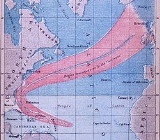
on October 29, and moved inland as far as Madrid. It peaked at 965 mbar (28.5 inHg) as a category 2 hurricane near Madeira on October 26. The storm can be considered a historical precedent for Hurricane Vince
Hurricane Vince (2005)
Hurricane Vince was an unusual hurricane that developed in the northeastern Atlantic basin. Forming in October during the 2005 Atlantic hurricane season, the waters over which it developed were considered too cold for tropical development...
of the 2005 Atlantic hurricane season
2005 Atlantic hurricane season
The 2005 Atlantic hurricane season was the most active Atlantic hurricane season in recorded history, repeatedly shattering numerous records. The impact of the season was widespread and ruinous with an estimated 3,913 deaths and record damage of about $159.2 billion...
.
1843 Atlantic hurricane season
A major hurricane moved northward through the Gulf of MexicoGulf of Mexico
The Gulf of Mexico is a partially landlocked ocean basin largely surrounded by the North American continent and the island of Cuba. It is bounded on the northeast, north and northwest by the Gulf Coast of the United States, on the southwest and south by Mexico, and on the southeast by Cuba. In...
. It hit Port Leon, Florida
Port Leon, Florida
Port Leon, Florida was a river port town located in what is now Wakulla County, Florida, which existed for only about six years in the first half of the 19th century...
, on September 13, destroying the town from the flooding and storm surge. Fourteen people were killed. The town residents moved the town three miles (5 km) northward to New Port, now called Newport, Florida
Newport, Florida
Newport is a small unincorporated community in Wakulla County, Florida, United States of America, situated where U.S. Highway 98 meets State Road 267.-1840s:...
.
1844 Atlantic hurricane season
I. A tropical storm hit near Lake Charles, LouisianaLake Charles, Louisiana
Lake Charles is the fifth-largest incorporated city in the U.S. state of Louisiana, located on Lake Charles, Prien Lake, and the Calcasieu River. Located in Calcasieu Parish, a major cultural, industrial, and educational center in the southwest region of the state, and one of the most important in...
, on June 11. It moved slowly northward to the west of the town, dissipating on the 15th.
II. A major hurricane moving through the Gulf of Mexico
Gulf of Mexico
The Gulf of Mexico is a partially landlocked ocean basin largely surrounded by the North American continent and the island of Cuba. It is bounded on the northeast, north and northwest by the Gulf Coast of the United States, on the southwest and south by Mexico, and on the southeast by Cuba. In...
hit the Rio Grande
Rio Grande
The Rio Grande is a river that flows from southwestern Colorado in the United States to the Gulf of Mexico. Along the way it forms part of the Mexico – United States border. Its length varies as its course changes...
valley on August 4. It slowly moved through the area, causing 70 deaths.
III. On September 8 a hurricane moved into Florida
Florida
Florida is a state in the southeastern United States, located on the nation's Atlantic and Gulf coasts. It is bordered to the west by the Gulf of Mexico, to the north by Alabama and Georgia and to the east by the Atlantic Ocean. With a population of 18,801,310 as measured by the 2010 census, it...
south of St. Augustine
St. Augustine, Florida
St. Augustine is a city in the northeast section of Florida and the county seat of St. Johns County, Florida, United States. Founded in 1565 by Spanish explorer and admiral Pedro Menéndez de Avilés, it is the oldest continuously occupied European-established city and port in the continental United...
. It moved across the state, emerging into the Gulf of Mexico
Gulf of Mexico
The Gulf of Mexico is a partially landlocked ocean basin largely surrounded by the North American continent and the island of Cuba. It is bounded on the northeast, north and northwest by the Gulf Coast of the United States, on the southwest and south by Mexico, and on the southeast by Cuba. In...
before turning northeastward and hitting Florida
Florida
Florida is a state in the southeastern United States, located on the nation's Atlantic and Gulf coasts. It is bordered to the west by the Gulf of Mexico, to the north by Alabama and Georgia and to the east by the Atlantic Ocean. With a population of 18,801,310 as measured by the 2010 census, it...
again on the 9th.
IV. On October 4, a hurricane hit Cuba
Cuba
The Republic of Cuba is an island nation in the Caribbean. The nation of Cuba consists of the main island of Cuba, the Isla de la Juventud, and several archipelagos. Havana is the largest city in Cuba and the country's capital. Santiago de Cuba is the second largest city...
, causing 101 deaths. It moved northeastward, bringing rain and strong winds to the United States
United States
The United States of America is a federal constitutional republic comprising fifty states and a federal district...
coastline but remaining offshore. The schooner revenue cutter Vigilant, USRC Vigilant
USRC Vigilant
Vigilant was one of the original ten cutters employed by the Federal government of the United States which made up the Revenue Marine, or Revenue Cutter Service, later to become the United States Coast Guard.-Operational history:...
, was lost off Key West during this hurricane on the 4th and 5th.
1846 Atlantic hurricane season
I. A possible hurricane hit near the mouth of the Mississippi RiverMississippi River
The Mississippi River is the largest river system in North America. Flowing entirely in the United States, this river rises in western Minnesota and meanders slowly southwards for to the Mississippi River Delta at the Gulf of Mexico. With its many tributaries, the Mississippi's watershed drains...
on April 3, causing heavy rain. It is unknown if it was a tropical system, due to the time of year. It is possibly like the Great Blizzard of 1993.
II. A slow-moving hurricane remained offshore of Cape Hatteras
Cape Hatteras
Cape Hatteras is a cape on the coast of North Carolina. It is the point that protrudes the farthest to the southeast along the northeast-to-southwest line of the Atlantic coast of North America...
on September 6. It pushed water into the Pamlico Sound
Pamlico Sound
Pamlico Sound in North Carolina, is the largest lagoon along the U.S. East Coast, being long and 24 to 48 km wide. It is a body of water separated from the Atlantic Ocean by the Outer Banks, a row of low, sandy barrier islands, including Cape Hatteras. The Neuse and Pamlico rivers flow in...
. When the hurricane moved far enough north, the northerly winds pushed the water back out, creating the Hatteras Inlet
Hatteras Inlet
Hatteras Inlet is a estuary in North Carolina, located along the Outer Banks, separating Hatteras Island and Ocracoke Island. It connects the Atlantic Ocean to the Pamlico Sound. Hatteras Inlet is located entirely within Hyde County.- History :...
and the Oregon Inlet
Oregon Inlet
Oregon Inlet is an inlet along North Carolina's Outer Banks. It joins the Pamlico Sound with the Atlantic Ocean and separates Bodie Island from Pea Island, which are connected by a 2.5 mile bridge that spans the inlet...
, the latter being named for the first large ship that could pass through the inlet.
III. On September 19, a gale destroyed 11 schooners from Marblehead, Massachusetts
Marblehead, Massachusetts
Marblehead is a town in Essex County, Massachusetts, United States. The population was 19,808 at the 2010 census. It is home to the Marblehead Neck Wildlife Sanctuary and Devereux Beach...
, and took 65 lives. It may have been a tropical cyclone. After this event, Gloucester took over as the center of New England fishing. (Rousmaniere)
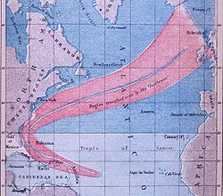
Great Havana Hurricane of 1846
IV. In October, a major hurricane, likely a Category 5, moved through the Caribbean SeaCaribbean Sea
The Caribbean Sea is a sea of the Atlantic Ocean located in the tropics of the Western hemisphere. It is bounded by Mexico and Central America to the west and southwest, to the north by the Greater Antilles, and to the east by the Lesser Antilles....
. It struck western Cuba
Cuba
The Republic of Cuba is an island nation in the Caribbean. The nation of Cuba consists of the main island of Cuba, the Isla de la Juventud, and several archipelagos. Havana is the largest city in Cuba and the country's capital. Santiago de Cuba is the second largest city...
on October 10, and hit the Florida Keys
Florida Keys
The Florida Keys are a coral archipelago in southeast United States. They begin at the southeastern tip of the Florida peninsula, about south of Miami, and extend in a gentle arc south-southwest and then westward to Key West, the westernmost of the inhabited islands, and on to the uninhabited Dry...
on the 11th, destroying the old Key West lighthouse and Fort Taylor. It headed northward, and on the 13th, it hit Tampa Bay
Tampa Bay
Tampa Bay is a large natural harbor and estuary along the Gulf of Mexico on the west central coast of Florida, comprising Hillsborough Bay, Old Tampa Bay, Middle Tampa Bay, and Lower Tampa Bay."Tampa Bay" is not the name of any municipality...
as a major hurricane. As it approached, it sucked the water out of the bay, causing the Manatee River
Manatee River
The Manatee River is a river in Manatee County, Florida. The river arises in the northeastern corner of Manatee County and flows into the Gulf of Mexico at the southern edge of Tampa Bay. The Manatee River has a watershed that is approximately . Lake Manatee, an artificial reservoir, is located...
to be so low you could walk a horse across it. The hurricane moved across Florida
Florida
Florida is a state in the southeastern United States, located on the nation's Atlantic and Gulf coasts. It is bordered to the west by the Gulf of Mexico, to the north by Alabama and Georgia and to the east by the Atlantic Ocean. With a population of 18,801,310 as measured by the 2010 census, it...
, and remained inland over Georgia
Georgia (U.S. state)
Georgia is a state located in the southeastern United States. It was established in 1732, the last of the original Thirteen Colonies. The state is named after King George II of Great Britain. Georgia was the fourth state to ratify the United States Constitution, on January 2, 1788...
, South Carolina
South Carolina
South Carolina is a state in the Deep South of the United States that borders Georgia to the south, North Carolina to the north, and the Atlantic Ocean to the east. Originally part of the Province of Carolina, the Province of South Carolina was one of the 13 colonies that declared independence...
, North Carolina
North Carolina
North Carolina is a state located in the southeastern United States. The state borders South Carolina and Georgia to the south, Tennessee to the west and Virginia to the north. North Carolina contains 100 counties. Its capital is Raleigh, and its largest city is Charlotte...
. It moved up the Chesapeake Bay
Chesapeake Bay
The Chesapeake Bay is the largest estuary in the United States. It lies off the Atlantic Ocean, surrounded by Maryland and Virginia. The Chesapeake Bay's drainage basin covers in the District of Columbia and parts of six states: New York, Pennsylvania, Delaware, Maryland, Virginia, and West...
, causing extensive damage through Virginia
Virginia
The Commonwealth of Virginia , is a U.S. state on the Atlantic Coast of the Southern United States. Virginia is nicknamed the "Old Dominion" and sometimes the "Mother of Presidents" after the eight U.S. presidents born there...
, Maryland
Maryland
Maryland is a U.S. state located in the Mid Atlantic region of the United States, bordering Virginia, West Virginia, and the District of Columbia to its south and west; Pennsylvania to its north; and Delaware to its east...
, Washington D.C., and Pennsylvania
Pennsylvania
The Commonwealth of Pennsylvania is a U.S. state that is located in the Northeastern and Mid-Atlantic regions of the United States. The state borders Delaware and Maryland to the south, West Virginia to the southwest, Ohio to the west, New York and Ontario, Canada, to the north, and New Jersey to...
. It caused around 163 deaths, and brought damage throughout the areas it affected. It is known as the Great Havana
Havana
Havana is the capital city, province, major port, and leading commercial centre of Cuba. The city proper has a population of 2.1 million inhabitants, and it spans a total of — making it the largest city in the Caribbean region, and the most populous...
Hurricane.
---Jay Barnes in "Florida's Hurricane History" actually states that Hector Braden, an area planter, drowned with his horse while crossing that very river in the height of the storm.---
1847 Atlantic hurricane season
A hurricane hit TobagoTobago
Tobago is the smaller of the two main islands that make up the Republic of Trinidad and Tobago. It is located in the southern Caribbean, northeast of the island of Trinidad and southeast of Grenada. The island lies outside the hurricane belt...
on October 11, resulting in 27 casualties.
1848 Atlantic hurricane season
Louisiana
Louisiana is a state located in the southern region of the United States of America. Its capital is Baton Rouge and largest city is New Orleans. Louisiana is the only state in the U.S. with political subdivisions termed parishes, which are local governments equivalent to counties...
, causing damage to cotton crops.
II. A hurricane tracked northeast of the Caribbean Sea
Caribbean Sea
The Caribbean Sea is a sea of the Atlantic Ocean located in the tropics of the Western hemisphere. It is bounded by Mexico and Central America to the west and southwest, to the north by the Greater Antilles, and to the east by the Lesser Antilles....
through the Bahamas and recurved through the North Atlantic shipping lanes towards Europe between August 19 and September 2. This storm was one of the earliest tropical cyclones to have a track created.
III. A major hurricane, the Great Gale of 1848
Great Gale of 1848
The Great Gale of 1848, also known as the Tampa Bay hurricane of 1848 and originally as the Great Gale of '48, was a tropical cyclone that struck Florida in September 1848. It affected the Tampa Bay Area September 23–25, 1848. It crossed the Florida Peninsula to cause damage on the east coast on or...
, hit near present-day Sarasota, Florida
Sarasota, Florida
Sarasota is a city located in Sarasota County on the southwestern coast of the U.S. state of Florida. It is south of the Tampa Bay Area and north of Fort Myers...
on September 25, creating a new waterway now called New Pass, named by William Whitaker
William Whitaker (pioneer)
William Henry Whitaker was an American Seminole War veteran and pioneer who, under the provisions of the Armed Occupation Act, established the first permanent settlement in what is now Sarasota, Florida. There he traded mullet with Cubans to bring the first groves of economically important oranges...
as the first person to see this new waterway. It made landfall in Tampa Bay
Tampa Bay
Tampa Bay is a large natural harbor and estuary along the Gulf of Mexico on the west central coast of Florida, comprising Hillsborough Bay, Old Tampa Bay, Middle Tampa Bay, and Lower Tampa Bay."Tampa Bay" is not the name of any municipality...
, near Fort Brooke
Fort Brooke
Fort Brooke was a historical military post situated on the east bank of the Hillsborough River in present-day Tampa, Florida. The Tampa Convention Center currently stands at the site.-Fort Brooke as a military outpost:...
and Tampa
Tampa, Florida
Tampa is a city in the U.S. state of Florida. It serves as the county seat for Hillsborough County. Tampa is located on the west coast of Florida. The population of Tampa in 2010 was 335,709....
, where tides rose 15 feet (4.6 m) and the barometric pressure dipped to 28.18 inches (715.8 mm). It crossed to the east coast where it damaged houses, caused flooding and interfered with shipping.
IV. An eastward moving major hurricane hit the Florida Panhandle
Florida Panhandle
The Florida Panhandle, an informal, unofficial term for the northwestern part of Florida, is a strip of land roughly 200 miles long and 50 to 100 miles wide , lying between Alabama on the north and the west, Georgia also on the north, and the Gulf of Mexico to the south. Its eastern boundary is...
on October 11.
V. On October 17, a minimal hurricane hit the southeast coast of Texas, causing flooding and high tides.
1849 Atlantic hurricane season
I. A tropical cycloneTropical cyclone
A tropical cyclone is a storm system characterized by a large low-pressure center and numerous thunderstorms that produce strong winds and heavy rain. Tropical cyclones strengthen when water evaporated from the ocean is released as the saturated air rises, resulting in condensation of water vapor...
may have moved into the Arklatex, as there was excessive flooding in northern sections of Louisiana
Louisiana
Louisiana is a state located in the southern region of the United States of America. Its capital is Baton Rouge and largest city is New Orleans. Louisiana is the only state in the U.S. with political subdivisions termed parishes, which are local governments equivalent to counties...
that August.
II. A minimal hurricane moved into the Rio Grande
Rio Grande
The Rio Grande is a river that flows from southwestern Colorado in the United States to the Gulf of Mexico. Along the way it forms part of the Mexico – United States border. Its length varies as its course changes...
river area on September 13.
III. A hurricane was first detected off the coast of North Carolina
North Carolina
North Carolina is a state located in the southeastern United States. The state borders South Carolina and Georgia to the south, Tennessee to the west and Virginia to the north. North Carolina contains 100 counties. Its capital is Raleigh, and its largest city is Charlotte...
in early October. It moved northeastward, passing close but remaining offshore of Long Island
Long Island
Long Island is an island located in the southeast part of the U.S. state of New York, just east of Manhattan. Stretching northeast into the Atlantic Ocean, Long Island contains four counties, two of which are boroughs of New York City , and two of which are mainly suburban...
. On October 6, it made landfall in Massachusetts
Massachusetts
The Commonwealth of Massachusetts is a state in the New England region of the northeastern United States of America. It is bordered by Rhode Island and Connecticut to the south, New York to the west, and Vermont and New Hampshire to the north; at its east lies the Atlantic Ocean. As of the 2010...
, causing 143 deaths.
See also
- List of tropical cyclones
- List of Atlantic hurricane seasons
Printed media
- John Rousmaniere. After the Storm: True Stories of Disaster and Recovery at Sea. McGraw-Hill Publishing, 2002.
World Wide Web
- List of Atlantic hurricane seasons
- Tampa and the Hurricane of 1848
- http://www.nhc.noaa.gov/pastdeadly.shtml
- http://www.rootsweb.com/~nchyde/HURICANE.HTM
- http://www.intellicast.com/Almanac/Southeast/October/content.shtml
- http://www.hpc.ncep.noaa.gov/research/txhur.pdf
- http://www.hpc.ncep.noaa.gov/research/lahur.pdf
- http://garnet.acns.fsu.edu/~jelsner/HHITProject/HHITyears/