

1693 Sicily earthquake
Encyclopedia
The 1693 Sicily earthquake refers to a powerful earthquake
that struck parts of southern Italy
, notably Sicily
, Calabria
and Malta
on January 11, 1693 around 9 pm local time. This earthquake was preceded by a damaging foreshock
on January 9th. It had an estimated magnitude of 7.4 on the moment magnitude scale
, the most powerful in Italian history, and a maximum intensity of XI (extreme) on the Mercalli intensity scale
, destroying at least 70 towns and cities, seriously affecting an area of 5600 square kilometres (2,162.2 sq mi) and causing the death of about 60,000. The earthquake was followed by tsunamis that devastated the coastal villages on the Ionian Sea
and in the Straits of Messina. Almost two thirds of the entire population of Catania
were killed. The epicentre
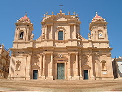
of the disaster was probably offshore, although the exact position remains unknown. The extent and degree of destruction caused by the earthquake resulted in extensive rebuilding of the towns and cities of southeastern Sicily, particularly the Val di Noto
, in a homogeneous late Baroque
style, described as "the culmination and final flowering of Baroque art in Europe".
According to a contemporary account of the earthquake by Vincentius Bonajutus, published in the Philosophical Transactions of the Royal Society
, "It was in this country impossible to keep upon our legs, or in one place on the dancing Earth; nay, those that lay along on the ground, were tossed from side to side, as if on a rolling billow."
where the African Plate
is subducting
beneath the Eurasian Plate
. This subduction zone is responsible for the formation of the stratovolcano
Mount Etna
and considerable seismic activity. Most damaging earthquakes however, occur on the Siculo-Calabrian rift zone. This zone of extensional faulting runs for about 370 kilometres (229.9 mi), forming three main segments through Calabria, along the east coast of Sicily and immediately offshore, and finally forming the southeastern margin of the Hyblean Plateau. Faults in the Calabrian segment were responsible for the 1783 Calabrian earthquakes
sequence.
In the southern part of the eastern coast of Sicily, investigations have identified a series of active normal faults, dipping to the east. Most of these lie offshore and some control basins that contain large thicknesses of Quaternary
sediments. The two largest faults, known as the western and eastern master faults, border half-grabens with fills of up to 700 metres (2,296.6 ft) and 800 metres (2,624.7 ft) respectively. Onshore, two ages of faulting have been recognised, an earlier phase trending NW-SE and a later phase trending SSW-NNE that clearly offsets the first group, including the Avola fault and the Rosolini-Ispica fault system.
. Intensities of VIII or higher have been estimated for Augusta, Avola Vecchia, Floridia
, Melilli
, Noto Antica
, Catania
, Francofonte
, Lentini
, Scicli
, Sortino
and Vizzini
. Augusta lies well outside the main zone of severe shaking, probably due to its construction on unconsolidated sediments.
From the shape and location of the area of maximum damage, this earthquake is thought to have been caused by movement on the Avola fault.
The source of the January 11 earthquake is debated. Some catalogues give an onshore epicentre without any direct association with a known structure, while others propose that the source was offshore due to the associated tsunami, involving either rupture along a normal fault, part of the Siculo-Calabrian rift zone, or rupture along the subduction zone beneath the Ionian Sea. An analysis of the distribution of tsunami run-ups along the coast suggests that a submarine landslide triggered by the earthquake is the most likely source, in which case the tsunami provides no constraint on the epicenter. A landslide origin is supported by the observation of possible landslide bodies along the Hyblean-Malta escarpment.
Historic documents in the Archivo General de Simancas
mention dozens of aftershocks, some as late as August 1694, and some reportedly as strong as the initial quake of January 11, 1693. Aftershocks continued until at least 1696, with their effects concentrated in towns along the coast, supporting an epicenter either near the coast or offshore.
.
Tsunami deposit
s linked to the 1693 tsunami have been found both onshore and offshore. At Ognina, just south of Syracuse, at the head of a ria
, a sequence containing several coarse clastic layers has been found, inconsistent with its lagoonal setting. The uppermost coarse layer, which has a strongly erosive base, consists of coarse sand with up to granule size clasts. The layer has been dated as 17th to 18th century based on pottery shards and one well-preserved clay pipe, consistent with the 1693 tsunami. Offshore from Augusta, a sequence identified using chirp
sonar
data was sampled with a 6.7 metres (22 ft) gravity core
in 72 metres (236.2 ft) of water. Following detailed analysis of both grain size and foraminifera
assemblages, eleven possible high-energy events were found based on the presence of large numbers of shallow water forams combined with a greater proportion of fine sand in the same interval. The uppermost two events correlate well with the tsunamis from the 1908 Messina earthquake
and the 1693 earthquake.
intrusion in the rift zones associated with the 1669 eruption, suggest that this could have helped to trigger the 1693 earthquake, by increasing stress levels on the faults.
, Ragusa
and Syracuse
. At least 70 cities, towns and villages were devastated, with some examples of at least partial building collapse as far afield as Messina, Agrigento
, Palermo
, Reggio Calabria
and Malta
.
The earthquake also triggered large landslides, such as at Noto Antica and Sortino, and in one case a large rock-slide dammed a stream, forming a lake a few kilometres long. Several large NW-SE trending fractures were created up to 500 metres (1,640.4 ft) long and 2 metres (6.6 ft) wide, on the plains just south of Catania. In the same area, sand volcano
es were formed by jets of water spurting as much as several metres into the air, with similar phenomena being reported from the Lentini plain and along some river valleys.
At Augusta the tsunami damaged galleys of the Knights of Malta that were anchored in the harbour when they were grounded during the initial withdrawal of the sea.
The number of deaths recorded at the time in official sources were about 12,000 in Catania (63% of the population), 5,045 in Ragusa (51%), 3,500 in Syracuse (23%) 3,000 in Noto (25%), 1,840 in Augusta (30%) and 3,400 in Modica
(19%). The total death toll in the same source was recorded as 54,000 with other sources referring to totals of about 60,000. Mallet
recorded 93,000 deaths in his catalogue of earthquakes in 1853.
by the Kings of Spain. The Viceroy in Madrid, the Duke of Uzeda
, reacted by appointing Giuseppe Lanza
, the Duke of Camastra, and the Prince of Aragon as Vicars General
for the Val Demone and Val di Noto regions of Sicily respectively. Unfortunately, due to illness, both the Prince of Aragon and his replacement the bishop of Syracuse were unable to take up the position of Vicar General for Val di Noto and the Duke of Camastra was forced to take on the responsibility for both areas. Camastra already had considerable experience as an administrator, having served in a number of senior military and judicial positions. The Viceroy also appointed three generals as commissioners in order to organise the immediate relief efforts in the worst affected cities. One of the Duke of Camastra's first acts was to temporarily exempt the worst affected areas from taxes. Amongst other administrators sent to the damaged area was Colonel Don Carlos von Grunemberg, Royal Engineer to the King of Spain, who had experience in planning and building fortifications.
In Palermo, the Viceroy formed two councils, a civil one made up of nobles, and another that was ecclesiastical, made up of senior church officials. They were directed to meet twice weekly, and were charged with the drawing up of plans for the reconstruction of the worst effected towns and cities.
The degree and extent of the damage caused by the earthquake prompted an architectural revival in the towns of Sicily
and Malta
, a style that has become known as Sicilian Baroque
. At this time many of the palazzi, public buildings, cathedrals and churches were reconstructed in this style. Towns that suffered serious damage from the earthquake in which many of their structures were rebuilt, include Syracuse, Ragusa
, Catania
, Caltagirone
, Palazzolo Acreide, Modica
, Comiso
, Scicli
and Mdina
on Malta
. Many of these towns now form part of the UNESCO World Heritage Site
Late Baroque Towns of the Val di Noto (South-Eastern Sicily), inscribed in 1992, referring to the "exceptional quality" of the region's art and architecture.
Earthquake
An earthquake is the result of a sudden release of energy in the Earth's crust that creates seismic waves. The seismicity, seismism or seismic activity of an area refers to the frequency, type and size of earthquakes experienced over a period of time...
that struck parts of southern Italy
Italy
Italy , officially the Italian Republic languages]] under the European Charter for Regional or Minority Languages. In each of these, Italy's official name is as follows:;;;;;;;;), is a unitary parliamentary republic in South-Central Europe. To the north it borders France, Switzerland, Austria and...
, notably Sicily
Sicily
Sicily is a region of Italy, and is the largest island in the Mediterranean Sea. Along with the surrounding minor islands, it constitutes an autonomous region of Italy, the Regione Autonoma Siciliana Sicily has a rich and unique culture, especially with regard to the arts, music, literature,...
, Calabria
Calabria
Calabria , in antiquity known as Bruttium, is a region in southern Italy, south of Naples, located at the "toe" of the Italian Peninsula. The capital city of Calabria is Catanzaro....
and Malta
Malta
Malta , officially known as the Republic of Malta , is a Southern European country consisting of an archipelago situated in the centre of the Mediterranean, south of Sicily, east of Tunisia and north of Libya, with Gibraltar to the west and Alexandria to the east.Malta covers just over in...
on January 11, 1693 around 9 pm local time. This earthquake was preceded by a damaging foreshock
Foreshock
A foreshock is an earthquake that occurs before a larger seismic event and is related to it in both time and space. The designation of an earthquake as foreshock, mainshock or aftershock is only possible after the event....
on January 9th. It had an estimated magnitude of 7.4 on the moment magnitude scale
Moment magnitude scale
The moment magnitude scale is used by seismologists to measure the size of earthquakes in terms of the energy released. The magnitude is based on the seismic moment of the earthquake, which is equal to the rigidity of the Earth multiplied by the average amount of slip on the fault and the size of...
, the most powerful in Italian history, and a maximum intensity of XI (extreme) on the Mercalli intensity scale
Mercalli intensity scale
The Mercalli intensity scale is a seismic scale used for measuring the intensity of an earthquake. It measures the effects of an earthquake, and is distinct from the moment magnitude M_w usually reported for an earthquake , which is a measure of the energy released...
, destroying at least 70 towns and cities, seriously affecting an area of 5600 square kilometres (2,162.2 sq mi) and causing the death of about 60,000. The earthquake was followed by tsunamis that devastated the coastal villages on the Ionian Sea
Ionian Sea
The Ionian Sea , is an arm of the Mediterranean Sea, south of the Adriatic Sea. It is bounded by southern Italy including Calabria, Sicily and the Salento peninsula to the west, southern Albania to the north, and a large number of Greek islands, including Corfu, Zante, Kephalonia, Ithaka, and...
and in the Straits of Messina. Almost two thirds of the entire population of Catania
Catania
Catania is an Italian city on the east coast of Sicily facing the Ionian Sea, between Messina and Syracuse. It is the capital of the homonymous province, and with 298,957 inhabitants it is the second-largest city in Sicily and the tenth in Italy.Catania is known to have a seismic history and...
were killed. The epicentre
Epicenter
The epicenter or epicentre is the point on the Earth's surface that is directly above the hypocenter or focus, the point where an earthquake or underground explosion originates...
of the disaster was probably offshore, although the exact position remains unknown. The extent and degree of destruction caused by the earthquake resulted in extensive rebuilding of the towns and cities of southeastern Sicily, particularly the Val di Noto
Val di Noto
Val di Noto is a geographical area of south east Sicily; it is dominated by the limestone Iblean plateau.-The Val di Noto in the Arts:...
, in a homogeneous late Baroque
Baroque
The Baroque is a period and the style that used exaggerated motion and clear, easily interpreted detail to produce drama, tension, exuberance, and grandeur in sculpture, painting, literature, dance, and music...
style, described as "the culmination and final flowering of Baroque art in Europe".
According to a contemporary account of the earthquake by Vincentius Bonajutus, published in the Philosophical Transactions of the Royal Society
Philosophical Transactions of the Royal Society
The Philosophical Transactions of the Royal Society is a scientific journal published by the Royal Society of London. It was established in 1665, making it the first journal in the world exclusively devoted to science, and it has remained in continuous publication ever since, making it the world's...
, "It was in this country impossible to keep upon our legs, or in one place on the dancing Earth; nay, those that lay along on the ground, were tossed from side to side, as if on a rolling billow."
Tectonic setting
Sicily lies on part of the complex convergent boundaryConvergent boundary
In plate tectonics, a convergent boundary, also known as a destructive plate boundary , is an actively deforming region where two tectonic plates or fragments of lithosphere move toward one another and collide...
where the African Plate
African Plate
The African Plate is a tectonic plate which includes the continent of Africa, as well as oceanic crust which lies between the continent and various surrounding ocean ridges.-Boundaries:...
is subducting
Subduction
In geology, subduction is the process that takes place at convergent boundaries by which one tectonic plate moves under another tectonic plate, sinking into the Earth's mantle, as the plates converge. These 3D regions of mantle downwellings are known as "Subduction Zones"...
beneath the Eurasian Plate
Eurasian Plate
The Eurasian Plate is a tectonic plate which includes most of the continent of Eurasia , with the notable exceptions of the Indian subcontinent, the Arabian subcontinent, and the area east of the Chersky Range in East Siberia...
. This subduction zone is responsible for the formation of the stratovolcano
Stratovolcano
A stratovolcano, also known as a composite volcano, is a tall, conical volcano built up by many layers of hardened lava, tephra, pumice, and volcanic ash. Unlike shield volcanoes, stratovolcanoes are characterized by a steep profile and periodic, explosive eruptions...
Mount Etna
Mount Etna
Mount Etna is an active stratovolcano on the east coast of Sicily, close to Messina and Catania. It is the tallest active volcano in Europe, currently standing high, though this varies with summit eruptions; the mountain is 21 m higher than it was in 1981.. It is the highest mountain in...
and considerable seismic activity. Most damaging earthquakes however, occur on the Siculo-Calabrian rift zone. This zone of extensional faulting runs for about 370 kilometres (229.9 mi), forming three main segments through Calabria, along the east coast of Sicily and immediately offshore, and finally forming the southeastern margin of the Hyblean Plateau. Faults in the Calabrian segment were responsible for the 1783 Calabrian earthquakes
1783 Calabrian earthquakes
The 1783 Calabrian earthquakes were a sequence of five strong earthquakes that hit the region of Calabria in southern Italy , the first two of which produced significant tsunamis. The epicenters form a clear alignment extending nearly 100 km from the Straits of Messina to about 18 km SSW...
sequence.
In the southern part of the eastern coast of Sicily, investigations have identified a series of active normal faults, dipping to the east. Most of these lie offshore and some control basins that contain large thicknesses of Quaternary
Quaternary
The Quaternary Period is the most recent of the three periods of the Cenozoic Era in the geologic time scale of the ICS. It follows the Neogene Period, spanning 2.588 ± 0.005 million years ago to the present...
sediments. The two largest faults, known as the western and eastern master faults, border half-grabens with fills of up to 700 metres (2,296.6 ft) and 800 metres (2,624.7 ft) respectively. Onshore, two ages of faulting have been recognised, an earlier phase trending NW-SE and a later phase trending SSW-NNE that clearly offsets the first group, including the Avola fault and the Rosolini-Ispica fault system.
January 9 foreshock
A destructive earthquake occurred two days before the mainshock at 21:00 local time, centered in the Val di Noto. It had an estimated magnitude of 6.2 and a maximum perceived intensity of VIII–XI on the Mercalli intensity scaleMercalli intensity scale
The Mercalli intensity scale is a seismic scale used for measuring the intensity of an earthquake. It measures the effects of an earthquake, and is distinct from the moment magnitude M_w usually reported for an earthquake , which is a measure of the energy released...
. Intensities of VIII or higher have been estimated for Augusta, Avola Vecchia, Floridia
Floridia
Floridia is a town and comune in the Province of Syracuse, Sicily .-Geography:Floridia lies 12 km west of Syracuse...
, Melilli
Melilli
Melilli is a comune in the Province of Syracuse, Sicily , located about 190 km southeast of Palermo and about 20 km northwest of Syracuse...
, Noto Antica
Noto
Noto is a city and comune in the Province of Syracuse, Sicily . Its located 32 km southwest of the city of Syracuse at the foot of the Iblean Mountains and gives its name to the surrounding valley, Val di Noto...
, Catania
Catania
Catania is an Italian city on the east coast of Sicily facing the Ionian Sea, between Messina and Syracuse. It is the capital of the homonymous province, and with 298,957 inhabitants it is the second-largest city in Sicily and the tenth in Italy.Catania is known to have a seismic history and...
, Francofonte
Francofonte
Francofonte is a comune in the Province of Syracuse, Sicily, southern Italy, located about 170 km southeast of Palermo and about 40 km northwest of Syracuse....
, Lentini
Lentini
Lentini , historically Leontini, Leontinoi , or Leontium, is a town and comune in the Province of Syracuse, southeast Sicily .-History:...
, Scicli
Scicli
*...
, Sortino
Sortino
Sortino is a town and comune in the Province of Syracuse, Sicily . It is located in the Anapo river valley....
and Vizzini
Vizzini
Vizzini is a town and comune in the province of Catania, on the island of Sicily. It is located 60 km from Catania in the Hyblaean Mountains, on the most northwesterly slopes of Monte Lauro....
. Augusta lies well outside the main zone of severe shaking, probably due to its construction on unconsolidated sediments.
From the shape and location of the area of maximum damage, this earthquake is thought to have been caused by movement on the Avola fault.
January 11 mainshock
The earthquake lasted for four minutes, according to contemporary accounts. The estimated magnitude of 7.4 is taken from the extent and degree of the recorded damage, with a very large area that reached X or more on the Mercalli scale.The source of the January 11 earthquake is debated. Some catalogues give an onshore epicentre without any direct association with a known structure, while others propose that the source was offshore due to the associated tsunami, involving either rupture along a normal fault, part of the Siculo-Calabrian rift zone, or rupture along the subduction zone beneath the Ionian Sea. An analysis of the distribution of tsunami run-ups along the coast suggests that a submarine landslide triggered by the earthquake is the most likely source, in which case the tsunami provides no constraint on the epicenter. A landslide origin is supported by the observation of possible landslide bodies along the Hyblean-Malta escarpment.
Historic documents in the Archivo General de Simancas
Archivo General de Simancas
The General Archive of Simancas is an official archive located in the castle of Simancas, province of Valladolid, Spain. It was founded in 1540, making this the first official archive of the Crown of Castile....
mention dozens of aftershocks, some as late as August 1694, and some reportedly as strong as the initial quake of January 11, 1693. Aftershocks continued until at least 1696, with their effects concentrated in towns along the coast, supporting an epicenter either near the coast or offshore.
Tsunami
The tsunami triggered by the earthquake affected most of the Ionian Sea coast of Sicily, about 230 kilometres (142.9 mi) in all. The first thing that was noted at all localities affected was a withdrawal of the sea. The strongest effects were concentrated around Augusta, where the initial withdrawal left the harbour dry, followed by a wave of at least 2.4 metres (7.9 ft) height, possibly as much as 8 metres (26.2 ft), that inundated part of the town. The maximum inundation of about 1.5 kilometre (0.93205910497471 mi) was recorded at MascaliMascali
Mascali is a comune in the Province of Catania in the Italian region Sicily, located about 170 km east of Palermo and about 30 km northeast of Catania....
.
Tsunami deposit
Tsunami deposit
A tsunami deposit is a sedimentary unit deposited as the result of of a tsunami. Such deposits may be left onshore during the inundation phase or offshore during the 'backwash' phase. Such deposits are being used to identify past tsunami events and thereby better constrain estimates of both...
s linked to the 1693 tsunami have been found both onshore and offshore. At Ognina, just south of Syracuse, at the head of a ria
Ria
A ria is a coastal inlet formed by the partial submergence of an unglaciated river valley. It is a drowned river valley that remains open to the sea. Typically, rias have a dendritic, treelike outline although they can be straight and without significant branches. This pattern is inherited from the...
, a sequence containing several coarse clastic layers has been found, inconsistent with its lagoonal setting. The uppermost coarse layer, which has a strongly erosive base, consists of coarse sand with up to granule size clasts. The layer has been dated as 17th to 18th century based on pottery shards and one well-preserved clay pipe, consistent with the 1693 tsunami. Offshore from Augusta, a sequence identified using chirp
Chirp
A chirp is a signal in which the frequency increases or decreases with time. In some sources, the term chirp is used interchangeably with sweep signal. It is commonly used in sonar and radar, but has other applications, such as in spread spectrum communications...
sonar
Sonar
Sonar is a technique that uses sound propagation to navigate, communicate with or detect other vessels...
data was sampled with a 6.7 metres (22 ft) gravity core
Core sample
A core sample is a cylindrical section of a naturally occurring substance. Most core samples are obtained by drilling with special drills into the substance, for example sediment or rock, with a hollow steel tube called a core drill. The hole made for the core sample is called the "core hole". A...
in 72 metres (236.2 ft) of water. Following detailed analysis of both grain size and foraminifera
Foraminifera
The Foraminifera , or forams for short, are a large group of amoeboid protists which are among the commonest plankton species. They have reticulating pseudopods, fine strands of cytoplasm that branch and merge to form a dynamic net...
assemblages, eleven possible high-energy events were found based on the presence of large numbers of shallow water forams combined with a greater proportion of fine sand in the same interval. The uppermost two events correlate well with the tsunamis from the 1908 Messina earthquake
1908 Messina earthquake
The 1908 Messina earthquake and tsunami took some 100,000–200,000 lives on December 28, 1908 in Sicily and Calabria, southern Italy.-Quake:On December 28, 1908 from about 05:20 to 05:21 an earthquake of 7.2 on the moment magnitude scale occurred centered on the of city Messina, in Sicily. Reggio...
and the 1693 earthquake.
Link to Eruption of Etna
Although there are reports of an eruption at the time of the earthquake, most sources suggest that the volcano had been inactive since the destructive eruption of 1669. Analysis of the relationship between eruptions and earthquakes has found that earthquakes are followed by long periods without activity in the 'rift zones' that extend out to north and south from the summit. Estimates of coulomb stress transfer due to the dykeDyke
Dyke or dike may refer to:* A levee, a natural or artificial slope or wall to regulate water levels* A ditch, a water filled drainage trench* A regional term for a dry stone wall...
intrusion in the rift zones associated with the 1669 eruption, suggest that this could have helped to trigger the 1693 earthquake, by increasing stress levels on the faults.
Damage
January 9 foreshock
Despite the difficulty of separating the effects of this event from the mainshock, some information is available. This earthquake caused widespread damage, particularly in Augusta where almost half of the houses were destroyed. Most of the buildings in two districts of Avola collapsed and many buildings were also destroyed in Noto, Floridia, Lentini and Mellili. Some buildings collapsed in Catania, Vizzini and Sortini. There were an estimated 200 casualties in both Augusta and Noto.January 11 mainshock
The area of severe damage covered most of southeastern Sicily, an area of about 14000 square kilometres (5,405.4 sq mi), including all the present provinces of CataniaProvince of Catania
Catania is a province in the autonomous island region of Sicily in Italy. Its capital is the city of Catania.It has an area of 3,552 km², and a total population of 1,073,881 . There are 58 comunes in the province, see Comunes of the Province of Catania...
, Ragusa
Province of Ragusa
The Province of Ragusa is a province in the autonomous region of Sicily in Italy, located in the south-east of the island. Its capital is the city of Ragusa, which is the most southerly provincial capital in Italy.-Geography:...
and Syracuse
Province of Syracuse
The Province of Syracuse is a province in the autonomous island region of Sicily in Italy. Its capital is the city of Syracuse.It has an area of 2,109 km², and a total population of 396,167 ....
. At least 70 cities, towns and villages were devastated, with some examples of at least partial building collapse as far afield as Messina, Agrigento
Agrigento
Agrigento , is a city on the southern coast of Sicily, Italy, and capital of the province of Agrigento. It is renowned as the site of the ancient Greek city of Akragas , one of the leading cities of Magna Graecia during the golden...
, Palermo
Palermo
Palermo is a city in Southern Italy, the capital of both the autonomous region of Sicily and the Province of Palermo. The city is noted for its history, culture, architecture and gastronomy, playing an important role throughout much of its existence; it is over 2,700 years old...
, Reggio Calabria
Reggio Calabria
Reggio di Calabria , commonly known as Reggio Calabria or Reggio, is the biggest city and the most populated comune of Calabria, southern Italy, and is the capital of the Province of Reggio Calabria and seat of the Council of Calabrian government.Reggio is located on the "toe" of the Italian...
and Malta
Malta
Malta , officially known as the Republic of Malta , is a Southern European country consisting of an archipelago situated in the centre of the Mediterranean, south of Sicily, east of Tunisia and north of Libya, with Gibraltar to the west and Alexandria to the east.Malta covers just over in...
.
The earthquake also triggered large landslides, such as at Noto Antica and Sortino, and in one case a large rock-slide dammed a stream, forming a lake a few kilometres long. Several large NW-SE trending fractures were created up to 500 metres (1,640.4 ft) long and 2 metres (6.6 ft) wide, on the plains just south of Catania. In the same area, sand volcano
Sand volcano
A sand volcano or sand blow is a cone of sand formed by the ejection of sand onto a surface from a central point. The sand builds up as a cone with slopes at the sand's angle of repose. A crater is commonly seen at the summit...
es were formed by jets of water spurting as much as several metres into the air, with similar phenomena being reported from the Lentini plain and along some river valleys.
At Augusta the tsunami damaged galleys of the Knights of Malta that were anchored in the harbour when they were grounded during the initial withdrawal of the sea.
The number of deaths recorded at the time in official sources were about 12,000 in Catania (63% of the population), 5,045 in Ragusa (51%), 3,500 in Syracuse (23%) 3,000 in Noto (25%), 1,840 in Augusta (30%) and 3,400 in Modica
Modica
-External links:*...
(19%). The total death toll in the same source was recorded as 54,000 with other sources referring to totals of about 60,000. Mallet
Robert Mallet
Robert Mallet FRS , Irish geophysicist, civil engineer, and inventor who distinguished himself in research on earthquakes and is sometimes called the father of seismology.-Early life:...
recorded 93,000 deaths in his catalogue of earthquakes in 1853.
Aftermath
Response
Sicily was at the time ruled as part of the Crown of AragonCrown of Aragon
The Crown of Aragon Corona d'Aragón Corona d'Aragó Corona Aragonum controlling a large portion of the present-day eastern Spain and southeastern France, as well as some of the major islands and mainland possessions stretching across the Mediterranean as far as Greece...
by the Kings of Spain. The Viceroy in Madrid, the Duke of Uzeda
Juan Francisco Pacheco y Téllez-Girón, 4th Consort Duke of Uceda
Juan Francisco Pacheco y Téllez-Girón, 4th Consort Duke of Uceda, , was a Spanish noble, viceroy of Sicily and Spanish Ambassador in Rome....
, reacted by appointing Giuseppe Lanza
Giuseppe Lanza
Giuseppe Lanza, Duke of Camastra, was a 17th century Sicilian nobleman who oversaw the reconstruction of many Sicilian towns and cities following the earthquake of 1693.He was created 1st Duke of Camastra, and Prince of Santo Stefano...
, the Duke of Camastra, and the Prince of Aragon as Vicars General
Vicar general
A vicar general is the principal deputy of the bishop of a diocese for the exercise of administrative authority. As vicar of the bishop, the vicar general exercises the bishop's ordinary executive power over the entire diocese and, thus, is the highest official in a diocese or other particular...
for the Val Demone and Val di Noto regions of Sicily respectively. Unfortunately, due to illness, both the Prince of Aragon and his replacement the bishop of Syracuse were unable to take up the position of Vicar General for Val di Noto and the Duke of Camastra was forced to take on the responsibility for both areas. Camastra already had considerable experience as an administrator, having served in a number of senior military and judicial positions. The Viceroy also appointed three generals as commissioners in order to organise the immediate relief efforts in the worst affected cities. One of the Duke of Camastra's first acts was to temporarily exempt the worst affected areas from taxes. Amongst other administrators sent to the damaged area was Colonel Don Carlos von Grunemberg, Royal Engineer to the King of Spain, who had experience in planning and building fortifications.
In Palermo, the Viceroy formed two councils, a civil one made up of nobles, and another that was ecclesiastical, made up of senior church officials. They were directed to meet twice weekly, and were charged with the drawing up of plans for the reconstruction of the worst effected towns and cities.
Reconstruction
The initial reconstruction efforts concentrated on restoring the military defences of Syracuse, Augusta, Catania and Acireale, due to their strategic importance. The reconstruction plans were of three types: move the town to a new site, rebuild at the same site with a completely new town plan or rebuild using the existing town plan. Examples of towns that fell in the first category were Avola and Noto, their former locations now being known as Avola Antica and Noto Antica. Catania is an example of a city that was rebuilt on the same site to a new plan, while adapting some of the existing structures. Syracuse is an example of a city rebuilt entirely to its existing plan. Ragusa was partly rebuilt on its old site to the medieval plan and partly on a new, but neighbouring site, to a 'modern' plan.The degree and extent of the damage caused by the earthquake prompted an architectural revival in the towns of Sicily
Sicily
Sicily is a region of Italy, and is the largest island in the Mediterranean Sea. Along with the surrounding minor islands, it constitutes an autonomous region of Italy, the Regione Autonoma Siciliana Sicily has a rich and unique culture, especially with regard to the arts, music, literature,...
and Malta
Malta
Malta , officially known as the Republic of Malta , is a Southern European country consisting of an archipelago situated in the centre of the Mediterranean, south of Sicily, east of Tunisia and north of Libya, with Gibraltar to the west and Alexandria to the east.Malta covers just over in...
, a style that has become known as Sicilian Baroque
Sicilian Baroque
Sicilian Baroque is the distinctive form of Baroque architecture that took hold on the island of Sicily, off the southern coast of Italy, in the 17th and 18th centuries...
. At this time many of the palazzi, public buildings, cathedrals and churches were reconstructed in this style. Towns that suffered serious damage from the earthquake in which many of their structures were rebuilt, include Syracuse, Ragusa
Ragusa, Italy
Ragusa is a city and comune in southern Italy. It is the capital of the province of Ragusa, on the island of Sicily, with around 75,000 inhabitants. It is built on a wide limestone hill between two deep valleys, Cava San Leonardo and Cava Santa Domenica...
, Catania
Catania
Catania is an Italian city on the east coast of Sicily facing the Ionian Sea, between Messina and Syracuse. It is the capital of the homonymous province, and with 298,957 inhabitants it is the second-largest city in Sicily and the tenth in Italy.Catania is known to have a seismic history and...
, Caltagirone
Caltagirone
Caltagirone is a town and comune in the province of Catania, on the island of Sicily, about 70 km southwest of Catania. It is bounded by the comuni of Acate, Gela, Grammichele, Licodia Eubea, Mazzarino, Mazzarrone, Mineo, Mirabella Imbaccari, Niscemi, Piazza Armerina, San Michele di...
, Palazzolo Acreide, Modica
Modica
-External links:*...
, Comiso
Comiso
Comiso is an Italian municipality in the Province of Ragusa in Sicily.-Geography:Comiso consists of three boroughs: Comiso, Pedalino, and Quaglio. It lies some 22 km west of Ragusa in the South of Sicily...
, Scicli
Scicli
*...
and Mdina
Mdina
Mdina, Città Vecchia, or Città Notabile, is the old capital of Malta. Mdina is a medieval walled town situated on a hill in the centre of the island. Punic remains uncovered beyond the city’s walls suggest the importance of the general region to Malta’s Phoenician settlers. Mdina is commonly...
on Malta
Malta
Malta , officially known as the Republic of Malta , is a Southern European country consisting of an archipelago situated in the centre of the Mediterranean, south of Sicily, east of Tunisia and north of Libya, with Gibraltar to the west and Alexandria to the east.Malta covers just over in...
. Many of these towns now form part of the UNESCO World Heritage Site
World Heritage Site
A UNESCO World Heritage Site is a place that is listed by the UNESCO as of special cultural or physical significance...
Late Baroque Towns of the Val di Noto (South-Eastern Sicily), inscribed in 1992, referring to the "exceptional quality" of the region's art and architecture.
See also
- Sicilian Baroque from 1693:Earthquake and patrons