
Wheldrake
Encyclopedia
Wheldrake is a village
and civil parish
located 7 miles (11.3 km) south-east of York
. Administratively it is in the unitary authority
of the City of York in North Yorkshire
, England
.
Wheldrake is a village, a civil parish and a name given to an electoral ward of the city of York, England. The village and parish are the focus of this article. According to the 2001 census the parish had a population of 1,909.
The parish of Wheldrake covers an area of 4300 acres (17.4 km²). It was established before 1066 and after being largely in the possession of Fountains Abbey
in the Middle Ages, it became part of a landed estate until the mid 20th century. It has a significant conservation area and a nature reserve of international importance. This, named Wheldrake Ings, is a mile east of the village, and is where many wild flowers flourish and rare birds prosper.
Most of the employed people who live in the village commute to work. There is a primary school, a church, a shop with post office and a public house which serve 761 households.
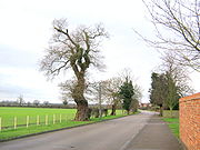
There is a small industrial estate near the western approach to the village.
Of the people who travel to work by motorised transport 653 travel by private means and 59 use public transport. The average journey to work is 21.73 km.
. It is situated 7 miles (11.3 km) to the south east of York
. It lies between the A19 trunk road and the River Derwent
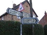
and is reached by an unclassified road which leaves the A19 at Crockey Hill. Minor roads to Thorganby
, Elvington
and Escrick
meet at Wheldrake.
There is a bus service to York which leaves Wheldrake every two hours. The journey to York takes 20 minutes.
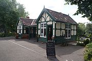 Between 1912 and 1926 Wheldrake was served by a passenger service on the Derwent Valley Light Railway
. The line was open for freight traffic until 1968. The former station is now preserved at the Yorkshire Museum of Farming
, at Murton
near York.
Bunter sandstone but in this area they are largely overlain by later glacial drift deposits. The village is sited on the slightly raised Escrick moraine
. This is one of the terminal moraine
s that was left in the Vale of York when the ice retreated at the end of the last ice age
. The resultant soils vary from thick clay
to sand and alluvium
and their fertility is consequently very variable.
The river Derwent flows in a southerly direction at the eastern boundary of the parish. This river was tidal until a flood barrier was built downstream in the mid 20th century. The height of the land is between 7 metres (23 ft) and 17 metres (55.8 ft).
climate which is influenced by the warming effect of the Gulf Stream
, it is slightly cooler than London. In the summer months the average maximum temperature is 20°C and the minimum is 11°C. In the winter the average maximum is 7°C and the minimum is 2°C. Average monthly precipitation varies between 68 mm in August and 37 mm in March. In May, June and July the sun shines for an average of six hours a day but in January and February there is an average of only one hour of sunshine. The weather is very variable from day to day. Extremes recorded at the University of York
campus (6 km from Wheldrake) between 1998 and 2006, include a highest temperature of 33°C and a lowest temperature of -6.9°C. The most rainfall in one day was 53.8 mm.
are part of the internationally-significant nature reserve
of the Lower Derwent Valley which is a site of special scientific interest (SSSI) and a Ramsar Convention
site. The Ings are areas of flood meadows along the river Derwent which flood seasonally and are rich in wildlife. They are mainly recognised for their significant collection of birds but they also support significant collections of mammals, plants and invertebrates.
Wheldrake Woods in the north of the parish was planted by the Forestry Commission
and has mainly conifer trees. The open cultivated agricultural land is not species-rich but the hedgerows, field margins and roadside verges support some small mammals and an increasing number of grasses and flowering plants.
or Roman field system is visible as crop marks. There are ditched enclosures, round houses, enclosures, a track way and possibly a square barrow
.
In 2002 a Roman farm was discovered at Wheldrake. Excavation of the site revealed structural remains, four Roman graves, animal bones, pottery and the remains of a main Roman road.
In Saxon
times Wheldrake was in the Danelaw
area of England and so probably consisted of a number of scattered family farming enclosures. In 1066 the land was held locally by a person called Norman but the overlord of the area was Morcar, Earl of Northumbria. It was worth 20 shillings in tax and there was enough arable land for four ploughs to be used.
After the Norman Conquest of England in 1066 Wheldrake was given by the new king, William I
to a follower called William Malet
.
By the time that the Domesday Book
was written in 1086 it belonged to William de Percy and was known as Coldrid. The local lord was William Coleville. There was extensive woodland, 20 acres (80,937.2 m²) of meadow, three fisheries, a water mill and the church.
From a nucleus of about 350 acres (1.4 km²) of land lying around a small deliberately-planned village of 16 plots the cultivated area began to be expanded.
In the 14th century the land was farmed as four open arable fields with common land for grazing animals.
Several gifts of land in Wheldrake were made to monasteries and by the end of the 15th century Fountains Abbey owned a large part of the land in the village.
When King Henry VIII dissolved the monasteries, the land in Wheldrake which had belonged to Fountains and other abbeys was confiscated and granted or sold to private individuals including Robert Robotham, servant to Edward VI
and Blanche Parry
, servant to Elizabeth I
. These individuals became the landlords, collecting rent from the farmers and householders who lived in the village.
In 1609 the open fields of Wheldrake still existed. There were 58 leaseholders and 13 freeholders in the village. There were 65 houses. Fifteen people rented only their dwelling houses. These included a weaver and a miller. There was a windmill in the village on a field which is still called Millfield.
In 1773 the landlord applied to parliament to enclose
the land of the manor
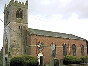
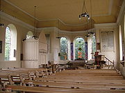
. It was then that the land was made into enclosed farms with fences and ditches around them. In 1778-9, the body of the village church was demolished and rebuilt in the Georgian style, although the thirteenth-century stone tower was retained.
 There were between 30 and 40 farmers in Wheldrake in the early part of the 19th century. Some lived on farms outside the built-up area of the village but many still had farmhouses with yards, barns and stables in the village Main Street. The chief crops that were grown were oats, peas, turnips and rape. Much of the farm land was used for pasture for animals or as hay meadows. Most of the land was still owned by a landlord and rented to the local farmers. At this time there were a large number of shopkeepers and traders in the village providing for the needs of agricultural workers in Wheldrake and the neighbouring villages.
 In the 20th century the main landowner sold many of the farms and houses that he owned in the village. These were bought by farmers and other private individuals. From the mid 20th century as people became more able to travel to their places of work and to larger shops in towns by motorised transport, the village shops and craft businesses suffered a decline in custom and started to close down. Conversely, people employed in towns found the rural environment attractive and chose to make their homes in Wheldrake. The result of this was an increase in the number of houses being built so that the old nucleus of the village is now almost surrounded by late 20th century housing developments.
, Wheldrake was transferred to the newly-formed North Yorkshire
county in the 1974 local government reorganisation. It became part of the City of York unitary authority in 1996. Prior to 1996 it had been part of the Selby
district.
The parish is part of the Wheldrake ward
of York, represented on York City Council by George Barton who is a member of the Conservative Party
.
constituency.
works and are usually accompanied by an accomplished orchestra of local musicians.
The local public house, The Wenlock, closed in May 2011. There is usually an annual exhibition by local artists and crafts people and two or three accept commissions for watercolours.
The Wheldrake Recreational Association provides a venue for sports and social activities and St Helens church promotes a number of Christian social groups. A mobile library visits every two weeks and there is a children's playground with basketball facilities for older children.
Local clubs use the tennis, football and cricket facilities at the village hall. Swallow Hall is the local golf course and there are two angling lakes,Raker Lakes and Westerly Lake. Public footpaths through the fields are maintained by York City council. The Wheldrake Woods and Wheldrake Ings are also popular with walkers.
The parish magazine Parish News is circulated to six hundred homes in the village each month and has a wealth of information about local interests. The radio stations are BBC Radio York
and 96.9 Viking FM
and the local newspaper is The Evening Press.
in York.
Village
A village is a clustered human settlement or community, larger than a hamlet with the population ranging from a few hundred to a few thousand , Though often located in rural areas, the term urban village is also applied to certain urban neighbourhoods, such as the West Village in Manhattan, New...
and civil parish
Civil parish
In England, a civil parish is a territorial designation and, where they are found, the lowest tier of local government below districts and counties...
located 7 miles (11.3 km) south-east of York
York
York is a walled city, situated at the confluence of the Rivers Ouse and Foss in North Yorkshire, England. The city has a rich heritage and has provided the backdrop to major political events throughout much of its two millennia of existence...
. Administratively it is in the unitary authority
Unitary authority
A unitary authority is a type of local authority that has a single tier and is responsible for all local government functions within its area or performs additional functions which elsewhere in the relevant country are usually performed by national government or a higher level of sub-national...
of the City of York in North Yorkshire
North Yorkshire
North Yorkshire is a non-metropolitan or shire county located in the Yorkshire and the Humber region of England, and a ceremonial county primarily in that region but partly in North East England. Created in 1974 by the Local Government Act 1972 it covers an area of , making it the largest...
, England
England
England is a country that is part of the United Kingdom. It shares land borders with Scotland to the north and Wales to the west; the Irish Sea is to the north west, the Celtic Sea to the south west, with the North Sea to the east and the English Channel to the south separating it from continental...
.
Wheldrake is a village, a civil parish and a name given to an electoral ward of the city of York, England. The village and parish are the focus of this article. According to the 2001 census the parish had a population of 1,909.
The parish of Wheldrake covers an area of 4300 acres (17.4 km²). It was established before 1066 and after being largely in the possession of Fountains Abbey
Fountains Abbey
Fountains Abbey is near to Aldfield, approximately two miles southwest of Ripon in North Yorkshire, England. It is a ruined Cistercian monastery, founded in 1132. Fountains Abbey is one of the largest and best preserved Cistercian houses in England. It is a Grade I listed building and owned by the...
in the Middle Ages, it became part of a landed estate until the mid 20th century. It has a significant conservation area and a nature reserve of international importance. This, named Wheldrake Ings, is a mile east of the village, and is where many wild flowers flourish and rare birds prosper.
Most of the employed people who live in the village commute to work. There is a primary school, a church, a shop with post office and a public house which serve 761 households.
There is a small industrial estate near the western approach to the village.
Demographics
According to the UK government 2001 census, Wheldrake had a population of 1909. The mean age of the population was 41.73 years, somewhat older than the national average of 38.6 years. There were 379 people below the age of 16 and 368 over the age of 64. The number of households was 761.Of the people who travel to work by motorised transport 653 travel by private means and 59 use public transport. The average journey to work is 21.73 km.
Situation and transport
Wheldrake is in the southern part of the Vale of YorkVale of York
The Vale of York is an area of flat land in the north-east of England. The vale is a major agricultural area and serves as the main north-south transport corridor for northern England....
. It is situated 7 miles (11.3 km) to the south east of York
York
York is a walled city, situated at the confluence of the Rivers Ouse and Foss in North Yorkshire, England. The city has a rich heritage and has provided the backdrop to major political events throughout much of its two millennia of existence...
. It lies between the A19 trunk road and the River Derwent
River Derwent, Yorkshire
The Derwent is a river in Yorkshire in the north of England. It is used for water abstraction, leisure and sporting activities and effluent disposal as well as being of significant importance as the site of several nature reserves...
and is reached by an unclassified road which leaves the A19 at Crockey Hill. Minor roads to Thorganby
Thorganby, North Yorkshire
Thorganby is a small village and civil parish in the Selbydistrict of North Yorkshire, England. It is situated next to the village of Wheldrake.-External links:*...
, Elvington
Elvington, City of York
Elvington is a village and civil parish situated approximately south-east of York, England, on the B1228 York-Howden road. According to the 2001 census the parish had a population of 1,212...
and Escrick
Escrick
Escrick is a village and civil parish in the Selby district of North Yorkshire, England. It is equidistant between Selby and York on what is now the A19 road....
meet at Wheldrake.
There is a bus service to York which leaves Wheldrake every two hours. The journey to York takes 20 minutes.
Derwent Valley Light Railway
The Derwent Valley Light Railway was a privately-owned standard-gauge railway running from Layerthorpe on the outskirts of York to Cliffe Common near Selby in North Yorkshire, England. It opened in 1913, and closed in sections between 1965 and 1981...
. The line was open for freight traffic until 1968. The former station is now preserved at the Yorkshire Museum of Farming
Yorkshire Museum of Farming
The Yorkshire Museum of Farming is located in Murton Park near York in England. It is housed on a grass field site of approximately , and is the only museum in the district specifically dedicated to the subject of farming. In the autumn of 2010, the museum was awarded full accreditation status by...
, at Murton
Murton, York
Murton is a small village and a civil parish in the unitary authority of the City of York in North Yorkshire, England that is located on the outskirts of York...
near York.
Physical geography
The rocks underlying this area in the south of the Vale of York are TriassicTriassic
The Triassic is a geologic period and system that extends from about 250 to 200 Mya . As the first period of the Mesozoic Era, the Triassic follows the Permian and is followed by the Jurassic. Both the start and end of the Triassic are marked by major extinction events...
Bunter sandstone but in this area they are largely overlain by later glacial drift deposits. The village is sited on the slightly raised Escrick moraine
Moraine
A moraine is any glacially formed accumulation of unconsolidated glacial debris which can occur in currently glaciated and formerly glaciated regions, such as those areas acted upon by a past glacial maximum. This debris may have been plucked off a valley floor as a glacier advanced or it may have...
. This is one of the terminal moraine
Terminal moraine
A terminal moraine, also called end moraine, is a moraine that forms at the end of the glacier called the snout.Terminal moraines mark the maximum advance of the glacier. An end moraine is at the present boundary of the glacier....
s that was left in the Vale of York when the ice retreated at the end of the last ice age
Ice age
An ice age or, more precisely, glacial age, is a generic geological period of long-term reduction in the temperature of the Earth's surface and atmosphere, resulting in the presence or expansion of continental ice sheets, polar ice sheets and alpine glaciers...
. The resultant soils vary from thick clay
Clay
Clay is a general term including many combinations of one or more clay minerals with traces of metal oxides and organic matter. Geologic clay deposits are mostly composed of phyllosilicate minerals containing variable amounts of water trapped in the mineral structure.- Formation :Clay minerals...
to sand and alluvium
Alluvium
Alluvium is loose, unconsolidated soil or sediments, eroded, deposited, and reshaped by water in some form in a non-marine setting. Alluvium is typically made up of a variety of materials, including fine particles of silt and clay and larger particles of sand and gravel...
and their fertility is consequently very variable.
The river Derwent flows in a southerly direction at the eastern boundary of the parish. This river was tidal until a flood barrier was built downstream in the mid 20th century. The height of the land is between 7 metres (23 ft) and 17 metres (55.8 ft).
Climate
Wheldrake is in the more northerly part of England and although it has a typically English temperateTemperate
In geography, temperate or tepid latitudes of the globe lie between the tropics and the polar circles. The changes in these regions between summer and winter are generally relatively moderate, rather than extreme hot or cold...
climate which is influenced by the warming effect of the Gulf Stream
Gulf Stream
The Gulf Stream, together with its northern extension towards Europe, the North Atlantic Drift, is a powerful, warm, and swift Atlantic ocean current that originates at the tip of Florida, and follows the eastern coastlines of the United States and Newfoundland before crossing the Atlantic Ocean...
, it is slightly cooler than London. In the summer months the average maximum temperature is 20°C and the minimum is 11°C. In the winter the average maximum is 7°C and the minimum is 2°C. Average monthly precipitation varies between 68 mm in August and 37 mm in March. In May, June and July the sun shines for an average of six hours a day but in January and February there is an average of only one hour of sunshine. The weather is very variable from day to day. Extremes recorded at the University of York
University of York
The University of York , is an academic institution located in the city of York, England. Established in 1963, the campus university has expanded to more than thirty departments and centres, covering a wide range of subjects...
campus (6 km from Wheldrake) between 1998 and 2006, include a highest temperature of 33°C and a lowest temperature of -6.9°C. The most rainfall in one day was 53.8 mm.
Natural history
The Wheldrake IngsDerwent Ings
Derwent Ings is a Site of Special Scientific Interest in the East Riding of Yorkshire, England. Derwent Ings is of international significance and has been designated a Wetland of International Importance under the Ramsar Convention and as a Special Protection Area under the terms of the European...
are part of the internationally-significant nature reserve
Nature reserve
A nature reserve is a protected area of importance for wildlife, flora, fauna or features of geological or other special interest, which is reserved and managed for conservation and to provide special opportunities for study or research...
of the Lower Derwent Valley which is a site of special scientific interest (SSSI) and a Ramsar Convention
Ramsar Convention
The Ramsar Convention is an international treaty for the conservation and sustainable utilization of wetlands, i.e., to stem the progressive encroachment on and loss of wetlands now and in the future, recognizing the fundamental ecological functions of wetlands and their economic, cultural,...
site. The Ings are areas of flood meadows along the river Derwent which flood seasonally and are rich in wildlife. They are mainly recognised for their significant collection of birds but they also support significant collections of mammals, plants and invertebrates.
Wheldrake Woods in the north of the parish was planted by the Forestry Commission
Forestry Commission
The Forestry Commission is a non-ministerial government department responsible for forestry in Great Britain. Its mission is to protect and expand Britain's forests and woodlands and increase their value to society and the environment....
and has mainly conifer trees. The open cultivated agricultural land is not species-rich but the hedgerows, field margins and roadside verges support some small mammals and an increasing number of grasses and flowering plants.
History
On air photographs an extensive Iron AgeIron Age
The Iron Age is the archaeological period generally occurring after the Bronze Age, marked by the prevalent use of iron. The early period of the age is characterized by the widespread use of iron or steel. The adoption of such material coincided with other changes in society, including differing...
or Roman field system is visible as crop marks. There are ditched enclosures, round houses, enclosures, a track way and possibly a square barrow
Tumulus
A tumulus is a mound of earth and stones raised over a grave or graves. Tumuli are also known as barrows, burial mounds, Hügelgrab or kurgans, and can be found throughout much of the world. A tumulus composed largely or entirely of stones is usually referred to as a cairn...
.
In 2002 a Roman farm was discovered at Wheldrake. Excavation of the site revealed structural remains, four Roman graves, animal bones, pottery and the remains of a main Roman road.
In Saxon
Anglo-Saxons
Anglo-Saxon is a term used by historians to designate the Germanic tribes who invaded and settled the south and east of Great Britain beginning in the early 5th century AD, and the period from their creation of the English nation to the Norman conquest. The Anglo-Saxon Era denotes the period of...
times Wheldrake was in the Danelaw
Danelaw
The Danelaw, as recorded in the Anglo-Saxon Chronicle , is a historical name given to the part of England in which the laws of the "Danes" held sway and dominated those of the Anglo-Saxons. It is contrasted with "West Saxon law" and "Mercian law". The term has been extended by modern historians to...
area of England and so probably consisted of a number of scattered family farming enclosures. In 1066 the land was held locally by a person called Norman but the overlord of the area was Morcar, Earl of Northumbria. It was worth 20 shillings in tax and there was enough arable land for four ploughs to be used.
After the Norman Conquest of England in 1066 Wheldrake was given by the new king, William I
William I of England
William I , also known as William the Conqueror , was the first Norman King of England from Christmas 1066 until his death. He was also Duke of Normandy from 3 July 1035 until his death, under the name William II...
to a follower called William Malet
William Malet (Norman conquest)
William Malet is one of the very few proven Companions of William the Conqueror known to have been present at the Battle of Hastings in 1066, as recorded by the contemporary chronicler William of Poitiers...
.
By the time that the Domesday Book
Domesday Book
Domesday Book , now held at The National Archives, Kew, Richmond upon Thames in South West London, is the record of the great survey of much of England and parts of Wales completed in 1086...
was written in 1086 it belonged to William de Percy and was known as Coldrid. The local lord was William Coleville. There was extensive woodland, 20 acres (80,937.2 m²) of meadow, three fisheries, a water mill and the church.
From a nucleus of about 350 acres (1.4 km²) of land lying around a small deliberately-planned village of 16 plots the cultivated area began to be expanded.
In the 14th century the land was farmed as four open arable fields with common land for grazing animals.
Several gifts of land in Wheldrake were made to monasteries and by the end of the 15th century Fountains Abbey owned a large part of the land in the village.
When King Henry VIII dissolved the monasteries, the land in Wheldrake which had belonged to Fountains and other abbeys was confiscated and granted or sold to private individuals including Robert Robotham, servant to Edward VI
Edward VI of England
Edward VI was the King of England and Ireland from 28 January 1547 until his death. He was crowned on 20 February at the age of nine. The son of Henry VIII and Jane Seymour, Edward was the third monarch of the Tudor dynasty and England's first monarch who was raised as a Protestant...
and Blanche Parry
Blanche Parry
Blanche Parry was a personal attendant of Queen Elizabeth I of England, Chief Gentlewoman of Queen Elizabeth’s most honourable Privy Chamber and Keeper of Her Majesty’s jewels.-Early life:...
, servant to Elizabeth I
Elizabeth I of England
Elizabeth I was queen regnant of England and Ireland from 17 November 1558 until her death. Sometimes called The Virgin Queen, Gloriana, or Good Queen Bess, Elizabeth was the fifth and last monarch of the Tudor dynasty...
. These individuals became the landlords, collecting rent from the farmers and householders who lived in the village.
In 1609 the open fields of Wheldrake still existed. There were 58 leaseholders and 13 freeholders in the village. There were 65 houses. Fifteen people rented only their dwelling houses. These included a weaver and a miller. There was a windmill in the village on a field which is still called Millfield.
In 1773 the landlord applied to parliament to enclose
Enclosure
Enclosure or inclosure is the process which ends traditional rights such as mowing meadows for hay, or grazing livestock on common land. Once enclosed, these uses of the land become restricted to the owner, and it ceases to be common land. In England and Wales the term is also used for the...
the land of the manor
Manorialism
Manorialism, an essential element of feudal society, was the organizing principle of rural economy that originated in the villa system of the Late Roman Empire, was widely practiced in medieval western and parts of central Europe, and was slowly replaced by the advent of a money-based market...
. It was then that the land was made into enclosed farms with fences and ditches around them. In 1778-9, the body of the village church was demolished and rebuilt in the Georgian style, although the thirteenth-century stone tower was retained.
Architecture and conservation
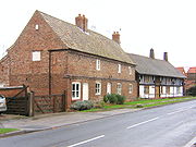
Wheldrake Conservation Area was designated in 1979. It comprises the historic Main Street, its continuation as Church Lane and the Back Lanes which were all established as part of the planned Medieval village. The parish church and 21 buildings are listed as being of significant historical interest.Politics
Historically part of the East Riding of YorkshireEast Riding of Yorkshire
The East Riding of Yorkshire, or simply East Yorkshire, is a local government district with unitary authority status, and a ceremonial county of England. For ceremonial purposes the county also includes the city of Kingston upon Hull, which is a separate unitary authority...
, Wheldrake was transferred to the newly-formed North Yorkshire
North Yorkshire
North Yorkshire is a non-metropolitan or shire county located in the Yorkshire and the Humber region of England, and a ceremonial county primarily in that region but partly in North East England. Created in 1974 by the Local Government Act 1972 it covers an area of , making it the largest...
county in the 1974 local government reorganisation. It became part of the City of York unitary authority in 1996. Prior to 1996 it had been part of the Selby
Selby (district)
Selby is a local government district of North Yorkshire, England. The local authority, Selby District Council, is based in the town of Selby and provides services to an area which includes Tadcaster and a host of villages....
district.
Local level
Wheldrake has a non-party political parish council.The parish is part of the Wheldrake ward
Wards of the United Kingdom
A ward in the United Kingdom is an electoral district at sub-national level represented by one or more councillors. It is the primary unit of British administrative and electoral geography .-England:...
of York, represented on York City Council by George Barton who is a member of the Conservative Party
Conservative Party (UK)
The Conservative Party, formally the Conservative and Unionist Party, is a centre-right political party in the United Kingdom that adheres to the philosophies of conservatism and British unionism. It is the largest political party in the UK, and is currently the largest single party in the House...
.
| Candidate | Party | Votes |
|---|---|---|
| Barton, George | Conservative | 970 |
| Dyson, William | Green Party | 65 |
| Vassie, Christian | Liberal Democrat | 457 |
| Watson, Susan | Labour | 234 |
| Electorate | 3,268 |
|---|---|
| Turnout | 53.60% |
| Candidate | Party | Votes |
|---|---|---|
| Martin, Margaret Ruth | Labour | 148 |
| Maughan, Jonathan Mark | Conservative | 638 |
| Shippey, Tracy Lynn | Green Party | 68 |
| Vassie, Christian | Liberal Democrat | 784 |
| Electorate | 3,218 |
|---|---|
| Turnout | 51.1% |
National level
Wheldrake became part of the newly created York Outer parliamentary constituency in the 2010 general election. Prior to that it was part of the SelbySelby (UK Parliament constituency)
Selby was a parliamentary constituency in North Yorkshire, represented in the House of Commons of the Parliament of the United Kingdom. It elected one Member of Parliament by the first past the post system of election....
constituency.
| Candidate | Party | Votes |
|---|---|---|
| Alexander, James | Labour | 9,108 |
| Kirk, Madeleine | Liberal Democrat | 19,224 |
| Morris, Judith | UKIP | 1,100 |
| Smurthwaite, Cathy | BNP | 956 |
| Sturdy, Julian Julian Sturdy Julian Charles Sturdy is a British Conservative Party politician. He was elected at the 2010 general election as Member of Parliament for York Outer.-Education:The son of Robert Sturdy Conservative Party MEP for the East of England... |
Conservative | 22,912 |
| Candidate | Party | Votes |
|---|---|---|
| Cuthbertson, Ian | Liberal Democrat | 7,770 |
| Grogan, John | Labour | 22,623 |
| Menzies, Mark | Conservative | 22,156 |
Culture, media and sport
The Wheldrake Singers is a local choral group that presents two or three concerts each year. They sing mostly BaroqueBaroque
The Baroque is a period and the style that used exaggerated motion and clear, easily interpreted detail to produce drama, tension, exuberance, and grandeur in sculpture, painting, literature, dance, and music...
works and are usually accompanied by an accomplished orchestra of local musicians.
The local public house, The Wenlock, closed in May 2011. There is usually an annual exhibition by local artists and crafts people and two or three accept commissions for watercolours.
The Wheldrake Recreational Association provides a venue for sports and social activities and St Helens church promotes a number of Christian social groups. A mobile library visits every two weeks and there is a children's playground with basketball facilities for older children.
Local clubs use the tennis, football and cricket facilities at the village hall. Swallow Hall is the local golf course and there are two angling lakes,Raker Lakes and Westerly Lake. Public footpaths through the fields are maintained by York City council. The Wheldrake Woods and Wheldrake Ings are also popular with walkers.
The parish magazine Parish News is circulated to six hundred homes in the village each month and has a wealth of information about local interests. The radio stations are BBC Radio York
BBC Radio York
BBC York is the BBC Local Radio service for the English county of North Yorkshire.- Early history :The station was launched at 6:30am on 4 July 1983 - a launch featured on the cover of the Radio Times...
and 96.9 Viking FM
96.9 Viking FM
96.9 Viking FM is an English Independent Local Radio station which has broadcast music and local information to the East Riding of Yorkshire, North Lincolnshire and North East Lincolnshire since 1984. It is based in Kingston upon Hull...
and the local newspaper is The Evening Press.
Business
The Millfield industrial estate at the western approaches to the village has seven units engaged in light industry and commerce. Farmers and a number of other self-employed people, including decorators, builder, joiners and plumbers run businesses from home. The Wenlock Arms as well as a village shop with a post office, a hairdresser, and undertaker are to be found along the Main Street.Education
Wheldrake with Thorganby C of E (Aided) Primary School caters for children up to the age of 11. The school has recently constructed an extension as the catchment area has seen an increase in the number of younger children and the original building became too small. Older pupils usually attend Fulford SchoolFulford School
Fulford School is a comprehensive school and a Maths and Computing College on Fulfordgate near Heslington Lane in Fulford, York, England.-History:It was founded in 1963 and has been a comprehensive school since 1970...
in York.