
.gif)
Western Freeway (Victoria)
Encyclopedia
The Western Freeway is a 125 kilometre Australia
n freeway linking the state capital of Victoria
(Melbourne
) to the major regional city of Ballarat. Signed as M8, it used to branch off from the Western Highway
(having come originally beyond the Victorian/South Australia
n border outside Adelaide) at Burrumbeet
, 22 kilometres north-west of Ballarat, and now ends officially to Melbourne's freeway network via the Western Ring Road, in the middle western suburbs of Melbourne. Both the freeway and Western Highway beyond Ballarat are part of the National Highway
network for the Melbourne-Adelaide route.
Plans are underway for the freeway to be extended west to Ararat
, and eventually, to Stawell
.
The Western Freeway subsumes and bypasses most sections of the older Western Highway. Former bypassed sections of the Western Highway are generally designated sequentially from C801 to C805, or Metropolitan Route 8 (although oddly enough, this used to still keep the old National Route 8 shield) (within suburban Melbourne).
The Melbourne section of the Western Highway is shown in the 1969 Melbourne Transportation Plan
as part of the F12 Freeway corridor.
. The freeway links the Western Freeway at Ravenhall
, and the Western Ring Road in Derrimut
. This 9.3 kilometre freeway was estimated to cost which also includes a grade separated interchange or a "full diamond" at Leakes Road in Rockbank
.
, which leads to the Western Ring Road. Due to the strong population growth of about 8.7 per cent and subdivision in Deer Park and Sunshine, the surrounding suburbs and the seven traffic signals between the Western Ring Road and the start of the Western Freeway
, substantial long and very frustrating delays were created for the 70,000 vehicles per day with 10 per cent of this consisting of heavy vehicles.
The bypass had been proposed since the completion of the Western Ring Road, the project stalled due to funding quarrels between the Federal and State Governments. In 2004, the Federal government
announced that the Deer Park Bypass would be built as part of a $1.4 billion project "package grant" to Victoria (Australia)
. It was anticipated that more than 15 min of travel time would be saved when travelling through Deer Park, via Ballarat Road.
Construction started on the Deer Park bypass in August 2006, work being carried out as a joint venture by Leighton Contractors and VicRoads
, in construction with two contracts. The first stage opened in December 2007.
On that day, Roads and Ports Minister Tim Pallas
and Federal Member for Gorton
Brendan O'Connor MP inspected works from the new bridge over the Ring Road at Sunshine West and Tim Pallas announced that the $331 million Deer Park Bypass would open to the public on Sunday 5 April 2009.
and Melton
was one of the most dangerous sections of the route, and was not of modern freeway standard. The steep hills and tight curves along the 5 kilometre long stretch of road resulted in 21 serious crashes in the five years to 2010. More than 29,000 vehicles per day, including more than 4000 freight vehicles, travel the highway section daily. The new route opened to traffic on 27 June 2011, nine months ahead of schedule.
The project included:
The original project scope included a diamond interchange at Bulmans Road that has not been built, while the ramps at Hopetoun Park Road were not included but was later added. The extension of Woolpack Road has been delayed due to need to clear trees in the heritage listed Avenue of Honour
at Bacchus Marsh.
Realignment of the road through this section had been proposed far back as 2001, when a group of 10 local councils said the realignment could cost just $65 million to build. By 2006 the cost was estimated to be $85 million, with federal Roads Minister Jim Lloyd stating that the project would receive serious consideration for funding in the 2009 AusLink
document, subject to support from the State Government. Construction commenced in February 2010, funded by $160 million from the Australian Government and $40 million from the Victorian Government.
 There are still several at-grade intersections on the "freeway", particularly in the areas near Rockbank
and at Woodmans Hill just to the east of Ballarat.
Australia
Australia , officially the Commonwealth of Australia, is a country in the Southern Hemisphere comprising the mainland of the Australian continent, the island of Tasmania, and numerous smaller islands in the Indian and Pacific Oceans. It is the world's sixth-largest country by total area...
n freeway linking the state capital of Victoria
Victoria (Australia)
Victoria is the second most populous state in Australia. Geographically the smallest mainland state, Victoria is bordered by New South Wales, South Australia, and Tasmania on Boundary Islet to the north, west and south respectively....
(Melbourne
Melbourne
Melbourne is the capital and most populous city in the state of Victoria, and the second most populous city in Australia. The Melbourne City Centre is the hub of the greater metropolitan area and the Census statistical division—of which "Melbourne" is the common name. As of June 2009, the greater...
) to the major regional city of Ballarat. Signed as M8, it used to branch off from the Western Highway
Western Highway, Victoria
The Western Highway is part of the principal route linking the Australian cities of Melbourne and Adelaide with a length of approximately 314 kilometres. It is a part of the National Highway network and designated as National Highway A8...
(having come originally beyond the Victorian/South Australia
South Australia
South Australia is a state of Australia in the southern central part of the country. It covers some of the most arid parts of the continent; with a total land area of , it is the fourth largest of Australia's six states and two territories.South Australia shares borders with all of the mainland...
n border outside Adelaide) at Burrumbeet
Burrumbeet, Victoria
Burrumbeet is a town in western Victoria, Australia. The town is located on the Western Highway, west of the state capital, Melbourne and west of the regional centre, Ballarat...
, 22 kilometres north-west of Ballarat, and now ends officially to Melbourne's freeway network via the Western Ring Road, in the middle western suburbs of Melbourne. Both the freeway and Western Highway beyond Ballarat are part of the National Highway
National Highway (Australia)
thumb|right|150px|The National Highway Shield in NSW, QLD, WA, NT & TAS.The National Highway is a system of roads connecting all the States and Territories of Australia, and is the major network of highways connecting Australia's largest and most important cities.The National Highway was...
network for the Melbourne-Adelaide route.
Plans are underway for the freeway to be extended west to Ararat
Ararat, Victoria
Ararat is a city in south-west Victoria, Australia, about west of Melbourne, on the Western Highway on the eastern slopes of the Ararat Hills and Cemetery Creek valley between Victoria's Western District and the Wimmera...
, and eventually, to Stawell
Stawell, Victoria
Stawell , is a town in the Wimmera region of Victoria, Australia. The town is located in Shire of Northern Grampians Local Government Area, west-north-west of the state capital, Melbourne. At the 2006 census, Stawell had a population of 6,035....
.
The Western Freeway subsumes and bypasses most sections of the older Western Highway. Former bypassed sections of the Western Highway are generally designated sequentially from C801 to C805, or Metropolitan Route 8 (although oddly enough, this used to still keep the old National Route 8 shield) (within suburban Melbourne).
The Melbourne section of the Western Highway is shown in the 1969 Melbourne Transportation Plan
1969 Melbourne Transportation Plan
The 1969 Melbourne Transportation Plan was a road and rail transport plan for Melbourne, the state capital of Victoria, Australia instituted by Henry Bolte's state government...
as part of the F12 Freeway corridor.
Deer Park Bypass
The Deer Park Bypass opened on 5 April 2009 in the western suburbs of MelbourneMelbourne
Melbourne is the capital and most populous city in the state of Victoria, and the second most populous city in Australia. The Melbourne City Centre is the hub of the greater metropolitan area and the Census statistical division—of which "Melbourne" is the common name. As of June 2009, the greater...
. The freeway links the Western Freeway at Ravenhall
Ravenhall, Victoria
Ravenhall is a bounded rural locality in Melbourne, Victoria, Australia, 22 km west from Melbourne's central business district, adjoining the Melbourne suburbs. Its Local Government Area is the Shire of Melton. At the 2006 Census, Ravenhall had a population of 575.Ravenhall is located south of the...
, and the Western Ring Road in Derrimut
Derrimut, Victoria
Derrimut is a suburb in Melbourne, Victoria, Australia, 18 km west from Melbourne's central business district. Its Local Government Area is the City of Brimbank. At the 2006 Census, Derrimut had a population of 1501....
. This 9.3 kilometre freeway was estimated to cost which also includes a grade separated interchange or a "full diamond" at Leakes Road in Rockbank
Rockbank, Victoria
Rockbank is a township and rural locality in Melbourne, Victoria, Australia, 29 km west from Melbourne's central business district. Its Local Government Area is the Shire of Melton. At the 2006 Census, Rockbank had a population of 1,337....
.
History
The purpose of the freeway bypass is to move traffic off Ballarat RoadBallarat Road, Melbourne
Ballarat Road is a major urban arterial road in the western suburbs of Melbourne, Victoria, Australia.-History:...
, which leads to the Western Ring Road. Due to the strong population growth of about 8.7 per cent and subdivision in Deer Park and Sunshine, the surrounding suburbs and the seven traffic signals between the Western Ring Road and the start of the Western Freeway
Western Freeway
Western Freeway or Western Expressway may mean:In roads:*Western Freeway , Virginia, United States*Western Freeway , Australia*Western Freeway, Brisbane, Australia*Western Freeway , India...
, substantial long and very frustrating delays were created for the 70,000 vehicles per day with 10 per cent of this consisting of heavy vehicles.
The bypass had been proposed since the completion of the Western Ring Road, the project stalled due to funding quarrels between the Federal and State Governments. In 2004, the Federal government
Government of Australia
The Commonwealth of Australia is a federal constitutional monarchy under a parliamentary democracy. The Commonwealth of Australia was formed in 1901 as a result of an agreement among six self-governing British colonies, which became the six states...
announced that the Deer Park Bypass would be built as part of a $1.4 billion project "package grant" to Victoria (Australia)
Victoria (Australia)
Victoria is the second most populous state in Australia. Geographically the smallest mainland state, Victoria is bordered by New South Wales, South Australia, and Tasmania on Boundary Islet to the north, west and south respectively....
. It was anticipated that more than 15 min of travel time would be saved when travelling through Deer Park, via Ballarat Road.
Construction started on the Deer Park bypass in August 2006, work being carried out as a joint venture by Leighton Contractors and VicRoads
VicRoads
VicRoads or the Roads Corporation of Victoria is a statutory corporation which is the state road and traffic authority in the state of Victoria, Australia. It is responsible for maintenance and construction of the state arterial road network, as well as driver licensing and vehicle registration. ...
, in construction with two contracts. The first stage opened in December 2007.
Opening brought forward
It was announced on 4 March 2009 that the Deer Park Bypass would open in early April 2009, with the new freeway link on track to open more than eight months ahead of schedule.On that day, Roads and Ports Minister Tim Pallas
Tim Pallas
Timothy Hugh Pallas is an Australian politician. He has been an Australian Labor Party member of the Victorian Legislative Assembly since 2006, representing the electorate of Tarneit...
and Federal Member for Gorton
Division of Gorton
The Division of Gorton is an Australian Electoral Division in Victoria. The division was created in 2004 and is named for Sir John Gorton, who was Prime Minister of Australia 1968-71...
Brendan O'Connor MP inspected works from the new bridge over the Ring Road at Sunshine West and Tim Pallas announced that the $331 million Deer Park Bypass would open to the public on Sunday 5 April 2009.
Anthony's Cutting Realignment
The section of road through Anthony's Cutting between Bacchus MarshBacchus Marsh, Victoria
Bacchus Marsh is an urban centre and suburban locality in Victoria, Australia located approximately west of Melbourne and west of Melton. The population of the urban area is estimated at over 17,000 people, while the central locality is home to 5,566 people...
and Melton
Melton, Victoria
Melton is an outer-suburban city of Melbourne Victoria, Australia located 35 km east from Melbourne's central business district. It is the administrative centre for the Shire of Melton Local Government Area. At the 2006 Census, the Shire of Melton had a population of 35,490...
was one of the most dangerous sections of the route, and was not of modern freeway standard. The steep hills and tight curves along the 5 kilometre long stretch of road resulted in 21 serious crashes in the five years to 2010. More than 29,000 vehicles per day, including more than 4000 freight vehicles, travel the highway section daily. The new route opened to traffic on 27 June 2011, nine months ahead of schedule.
The project included:
- Extension of Woolpack Road north from Bacchus Marsh Road to a new interchange on the Western Freeway, including a bridge over the Lerderderg RiverLerderderg RiverThe Lerderderg River is a river in Victoria, Australia. The river begins in the Lerderderg State Forest and ends when it merges into the Werribee River just out of the town of Bacchus Marsh....
. - An overpass carrying Bulmans Road over the existing Western Freeway.
- An overpass taking Hopetoun Park Road across the new freeway, with Melbourne-bound on and off ramps.
- Freeway bridges spanning Djerriwarrh Creek, and Cowans Road / Pyrites Creek.
The original project scope included a diamond interchange at Bulmans Road that has not been built, while the ramps at Hopetoun Park Road were not included but was later added. The extension of Woolpack Road has been delayed due to need to clear trees in the heritage listed Avenue of Honour
Avenue of honour
Avenue of Honour is the term given to a memorial avenue of trees, with each tree symbolising a person.The tradition, which originated in the Goldfields region of Victoria, Australia is an important part of Australian culture....
at Bacchus Marsh.
Realignment of the road through this section had been proposed far back as 2001, when a group of 10 local councils said the realignment could cost just $65 million to build. By 2006 the cost was estimated to be $85 million, with federal Roads Minister Jim Lloyd stating that the project would receive serious consideration for funding in the 2009 AusLink
AusLink
AusLink was an Australian Government land transport funding program, established in June 2004 and administered by the Department of Transport and Regional Services. In 2009 it was replaced with the Nation Building Program under the Nation Building Program Act 2009...
document, subject to support from the State Government. Construction commenced in February 2010, funded by $160 million from the Australian Government and $40 million from the Victorian Government.
Future upgrades
Rockbank, Victoria
Rockbank is a township and rural locality in Melbourne, Victoria, Australia, 29 km west from Melbourne's central business district. Its Local Government Area is the Shire of Melton. At the 2006 Census, Rockbank had a population of 1,337....
and at Woodmans Hill just to the east of Ballarat.
- Proposed upgrade and safety improvements Rockbank to Melton, to be funded by Auslink 2 (2009–2014)http://www.doi.vic.gov.au/DOI/DOIElect.nsf/$UNIDS+for+Web+Display/5890F76B538ED7A3CA2573A80015B343/$FILE/AusLink2_WesternFreewayRockbank.pdf.
- Proposed extension west through Ararat and eventually to Stawell, also part of Auslink 2.
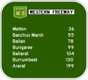
Towns
Towns along the way include:- Ballarat
- BungareeBungaree, VictoriaBungaree is a town in Victoria, Australia. The town is located west of the state capital, Melbourne and east of the regional centre of Ballarat, on the Western Freeway and in the Shire of Moorabool local government area. At the 2006 census, Bungaree and the surrounding area had a population of...
- BallanBallan, VictoriaBallan is a small town in the state of Victoria, Australia located on the Werribee River north west of Melbourne. At the 2006 census, Ballan had a population of 1,807.It is the main administrative centre for the Shire of Moorabool Local Government Area....
- Bacchus MarshBacchus Marsh, VictoriaBacchus Marsh is an urban centre and suburban locality in Victoria, Australia located approximately west of Melbourne and west of Melton. The population of the urban area is estimated at over 17,000 people, while the central locality is home to 5,566 people...
- MeltonMelton, VictoriaMelton is an outer-suburban city of Melbourne Victoria, Australia located 35 km east from Melbourne's central business district. It is the administrative centre for the Shire of Melton Local Government Area. At the 2006 Census, the Shire of Melton had a population of 35,490...
- RockbankRockbank, VictoriaRockbank is a township and rural locality in Melbourne, Victoria, Australia, 29 km west from Melbourne's central business district. Its Local Government Area is the Shire of Melton. At the 2006 Census, Rockbank had a population of 1,337....
Exits and Intersections
Western Freeway  |
|||
Westbound exits / intersections .svg.png) |
Distance to Adelaide (km) |
Distance to Melbourne (km) |
Eastbound exits / intersections |
| End Western Freeway continues as Western Highway Western Highway, Victoria The Western Highway is part of the principal route linking the Australian cities of Melbourne and Adelaide with a length of approximately 314 kilometres. It is a part of the National Highway network and designated as National Highway A8...  to Horsham Horsham, Victoria Horsham is the largest city by population and regional centre of the Wimmera region of Victoria, Australia and is approximately north-west of Melbourne via the Western Highway. At the 2006 census, Horsham had a population of 14,125. Horsham is in the federal Division of Mallee... / Adelaide Adelaide Adelaide is the capital city of South Australia and the fifth-largest city in Australia. Adelaide has an estimated population of more than 1.2 million... |
586 | 143 | Start Western Freeway from Western Highway Western Highway, Victoria The Western Highway is part of the principal route linking the Australian cities of Melbourne and Adelaide with a length of approximately 314 kilometres. It is a part of the National Highway network and designated as National Highway A8... |
| Wendouree Wendouree, Victoria Wendouree is a large suburb on the north western rural-urban fringe of the City of Ballarat, in Victoria, Australia. It is the most populated suburb in urban Ballarat with a total of 10,752 inhabitants counted at the 2006 Census.... , Ballarat Old Western Highway  |
|||
| WESTERN RAIL LINE | 592 | 137 | WESTERN RAIL LINE |
| Avoca Avoca, Victoria Avoca is a town in the Central Highlands of Victoria, Australia, north west of Ballarat. It is one of two main towns in the Pyrenees Shire, the other being Beaufort to the south. At the 2006 census, Avoca had a population of 951.-Geography:... , Mildura Mildura, Victoria Mildura is a regional city in northwestern Victoria, Australia and seat of the Rural City of Mildura local government area. It is located in the Sunraysia region, and is on the banks of the Murray River. The current population is estimated at just over 30,000.Mildura is a major agricultural centre... Sunraysia Highway Sunraysia Highway The Sunraysia Highway , is a important north-south route in western Victoria. The highway extends north a length of 331 km from the Western Highway near Ballarat to the Calder Highway near Ouyen....  |
600 | 129 | Avoca Avoca, Victoria Avoca is a town in the Central Highlands of Victoria, Australia, north west of Ballarat. It is one of two main towns in the Pyrenees Shire, the other being Beaufort to the south. At the 2006 census, Avoca had a population of 951.-Geography:... , Mildura Mildura, Victoria Mildura is a regional city in northwestern Victoria, Australia and seat of the Rural City of Mildura local government area. It is located in the Sunraysia region, and is on the banks of the Murray River. The current population is estimated at just over 30,000.Mildura is a major agricultural centre... Sunraysia Highway Sunraysia Highway The Sunraysia Highway , is a important north-south route in western Victoria. The highway extends north a length of 331 km from the Western Highway near Ballarat to the Calder Highway near Ouyen.... |
| Ballarat, Maryborough Maryborough, Victoria -Education:Maryborough has three schools:*Highview Christian Community College*Maryborough Education Centre Years Prep–12*St Augustine's Primary School Grades Prep–6-Music:... Ballarat-Maryborough Road  |
602 | 127 | Maryborough Maryborough, Victoria -Education:Maryborough has three schools:*Highview Christian Community College*Maryborough Education Centre Years Prep–12*St Augustine's Primary School Grades Prep–6-Music:... , Ballarat Ballarat-Maryborough Road |
| Wendouree Wendouree, Victoria Wendouree is a large suburb on the north western rural-urban fringe of the City of Ballarat, in Victoria, Australia. It is the most populated suburb in urban Ballarat with a total of 10,752 inhabitants counted at the 2006 Census.... , Clunes Clunes, Victoria Clunes is a town in Victoria, Australia, located 36 kilometres north of Ballarat, in the Shire of Hepburn. At the 2006 census it had a population of 1,026.- History :... Gillies Street  |
604 | 125 | no exit |
| Geelong, Bendigo Midland Highway   |
606 | 123 | Bendigo, Geelong Midland Highway |
| Brown Hill Brown Hill, Victoria Brown Hill is a suburb of Ballarat, Victoria, Australia on the eastern rural-urban fringe of the city. The population at the 2006 census was 2,057.... , Daylesford Daylesford, Victoria Daylesford is a town located in the Shire of Hepburn, Victoria, Australia. It is a former goldmining town about 115 kilometres north-west of Melbourne, in the foothills of the Great Dividing Range. At the 2006 census, Daylesford had a population of 3,073... Ballarat-Daylesford Road  |
612 | 117 | Daylesford Daylesford, Victoria Daylesford is a town located in the Shire of Hepburn, Victoria, Australia. It is a former goldmining town about 115 kilometres north-west of Melbourne, in the foothills of the Great Dividing Range. At the 2006 census, Daylesford had a population of 3,073... , Brown Hill Brown Hill, Victoria Brown Hill is a suburb of Ballarat, Victoria, Australia on the eastern rural-urban fringe of the city. The population at the 2006 census was 2,057.... Ballarat-Daylesford Road |
| Ballarat Ballarat-Burrumbeet Road |
614 | 115 | no exit |
| Clarks Road |
615 | 114 | no intersection |
| Brewery Tap Road |
617 | 112 | Brewery Tap Road |
| Mount Edgerton Old Melbourne Road |
Mount Edgerton Old Melbourne Road |
||
| Greene Road |
618 | 111 | no intersection |
| no intersection | 619 | 110 | Richards Road |
| Forbes Road / Black Swamp Road |
621 | 108 | Black Swamp Road / Forbes Road |
| Bungaree Bungaree-Wallace Road  |
624 | 105 | Bungaree Bungaree-Wallace Road |
| Bungaree, Creswick Creswick, Victoria Creswick is a town in west-central Victoria, Australia. It is located 18 kilometres north of Ballarat and 129 km northwest of Melbourne, in Shire of Hepburn. It is 430 metres above sea level. At the 2006 census, Creswick had a population of 2,485... Bungaree-Creswick Road  |
626 | 103 | Creswick Creswick, Victoria Creswick is a town in west-central Victoria, Australia. It is located 18 kilometres north of Ballarat and 129 km northwest of Melbourne, in Shire of Hepburn. It is 430 metres above sea level. At the 2006 census, Creswick had a population of 2,485... , Bungaree Bungaree-Creswick Road |
| Wallace Wallace, Victoria Wallace is a town in Victoria, Australia. The town is located in the Shire of Moorabool Local Government Area, north west of the state capital, Melbourne.The township was established in the 1880s, the Post Office opening on 22 February 1885.... , Springbark Bungaree-Wallace Road /Ormond Road |
632 | 97 | Springbark, Wallace Wallace, Victoria Wallace is a town in Victoria, Australia. The town is located in the Shire of Moorabool Local Government Area, north west of the state capital, Melbourne.The township was established in the 1880s, the Post Office opening on 22 February 1885.... Ormond Road / Bungaree-Wallace Road |
| Gordon Gordon, Victoria Gordon is a town in Victoria, Australia. The town is located in the Shire of Moorabool Local Government Area, west of the state capital, Melbourne. At the 2006 census, Gordon had a population of 453.... Brougham Street / Abbington Park Road |
637 | 92 | Gordon Gordon, Victoria Gordon is a town in Victoria, Australia. The town is located in the Shire of Moorabool Local Government Area, west of the state capital, Melbourne. At the 2006 census, Gordon had a population of 453.... Brougham Street / Abbington Park Road |
| Ballan Ballan, Victoria Ballan is a small town in the state of Victoria, Australia located on the Werribee River north west of Melbourne. At the 2006 census, Ballan had a population of 1,807.It is the main administrative centre for the Shire of Moorabool Local Government Area.... , Daylesford Daylesford, Victoria Daylesford is a town located in the Shire of Hepburn, Victoria, Australia. It is a former goldmining town about 115 kilometres north-west of Melbourne, in the foothills of the Great Dividing Range. At the 2006 census, Daylesford had a population of 3,073... Ballan-Daylesford Road  |
647 | 82 | Daylesford Daylesford, Victoria Daylesford is a town located in the Shire of Hepburn, Victoria, Australia. It is a former goldmining town about 115 kilometres north-west of Melbourne, in the foothills of the Great Dividing Range. At the 2006 census, Daylesford had a population of 3,073... , Ballan Ballan, Victoria Ballan is a small town in the state of Victoria, Australia located on the Werribee River north west of Melbourne. At the 2006 census, Ballan had a population of 1,807.It is the main administrative centre for the Shire of Moorabool Local Government Area.... Ballan-Daylesford Road |
| BP SERVICE CENTRE BP BP p.l.c. is a global oil and gas company headquartered in London, United Kingdom. It is the third-largest energy company and fourth-largest company in the world measured by revenues and one of the six oil and gas "supermajors"... |
650 | 79 | BP SERVICE CENTRE BP BP p.l.c. is a global oil and gas company headquartered in London, United Kingdom. It is the third-largest energy company and fourth-largest company in the world measured by revenues and one of the six oil and gas "supermajors"... |
| Ballan Ballan, Victoria Ballan is a small town in the state of Victoria, Australia located on the Werribee River north west of Melbourne. At the 2006 census, Ballan had a population of 1,807.It is the main administrative centre for the Shire of Moorabool Local Government Area.... Old Melbourne Road  |
652 | 77 | Ballan Ballan, Victoria Ballan is a small town in the state of Victoria, Australia located on the Werribee River north west of Melbourne. At the 2006 census, Ballan had a population of 1,807.It is the main administrative centre for the Shire of Moorabool Local Government Area.... Old Melbourne Road |
| Kyneton Kyneton, Victoria Kyneton is a town on the Calder Highway in the Macedon Ranges of Victoria, Australia. The Calder Freeway bypasses Kyneton to the north and east. The town was named after the English village of Kineton, Warwickshire. The town has three main streets: Mollison Street, Piper Street and High Street... Greendale-Myrniong Road  |
658 | 71 | Kyneton Kyneton, Victoria Kyneton is a town on the Calder Highway in the Macedon Ranges of Victoria, Australia. The Calder Freeway bypasses Kyneton to the north and east. The town was named after the English village of Kineton, Warwickshire. The town has three main streets: Mollison Street, Piper Street and High Street... Greendale-Myrniong Road |
| Pentland Hills Pentland Hills Road |
664 | 65 | Pentland Hills Pentland Hills Road |
| Pentland Hills Mortons Road / Pentland Hills Road |
667 | 62 | no exit |
| no exit | 669 | 60 | Bacchus Marsh Bacchus Marsh, Victoria Bacchus Marsh is an urban centre and suburban locality in Victoria, Australia located approximately west of Melbourne and west of Melton. The population of the urban area is estimated at over 17,000 people, while the central locality is home to 5,566 people... Bacchus Marsh Road  |
| Geelong, Gisborne Gisborne, Victoria Gisborne is a town located approximately northwest of Melbourne, Victoria, Australia. As it is close to Melbourne, but in attractive countryside, it is proving an increasingly popular place to settle. The town was named after Henry Fyshe Gisborne , the first Commissioner for Crown Lands of the... Bacchus Marsh-Gisborne Road  |
671 | 58 | Gisborne Gisborne, Victoria Gisborne is a town located approximately northwest of Melbourne, Victoria, Australia. As it is close to Melbourne, but in attractive countryside, it is proving an increasingly popular place to settle. The town was named after Henry Fyshe Gisborne , the first Commissioner for Crown Lands of the... , Geelong Bacchus Marsh-Gisborne Road |
| Bacchus Marsh Bacchus Marsh, Victoria Bacchus Marsh is an urban centre and suburban locality in Victoria, Australia located approximately west of Melbourne and west of Melton. The population of the urban area is estimated at over 17,000 people, while the central locality is home to 5,566 people... Bacchus Marsh Road |
676 | 53 | Bacchus Marsh Bacchus Marsh, Victoria Bacchus Marsh is an urban centre and suburban locality in Victoria, Australia located approximately west of Melbourne and west of Melton. The population of the urban area is estimated at over 17,000 people, while the central locality is home to 5,566 people... Bacchus Marsh Road |
| Hopetoun Park Hopetoun Park Road |
678 | 51 | no exit |
| Exford Exford, Victoria Exford is a town in Victoria, Australia, 51 km west from Melbourne's central business district. Its Local Government Area is the Shire of Melton.... , Melton Melton, Victoria Melton is an outer-suburban city of Melbourne Victoria, Australia located 35 km east from Melbourne's central business district. It is the administrative centre for the Shire of Melton Local Government Area. At the 2006 Census, the Shire of Melton had a population of 35,490... Coburns Road  |
684 | 45 | Melton Melton, Victoria Melton is an outer-suburban city of Melbourne Victoria, Australia located 35 km east from Melbourne's central business district. It is the administrative centre for the Shire of Melton Local Government Area. At the 2006 Census, the Shire of Melton had a population of 35,490... , Exford Exford, Victoria Exford is a town in Victoria, Australia, 51 km west from Melbourne's central business district. Its Local Government Area is the Shire of Melton.... Coburns Road |
| Melton South Melton South, Victoria Melton South is a suburb in Melbourne, Victoria, Australia, 35 km west from Melbourne's central business district. Its Local Government Area is the Shire of Melton. At the 2006 Census, Melton South had a population of 8,800.-History:... , Gisborne Gisborne, Victoria Gisborne is a town located approximately northwest of Melbourne, Victoria, Australia. As it is close to Melbourne, but in attractive countryside, it is proving an increasingly popular place to settle. The town was named after Henry Fyshe Gisborne , the first Commissioner for Crown Lands of the... Ferris Road / Melton Highway Melton Highway Melton Highway links Melbourne's outer north-western suburbs of Melton and Taylors Lakes ; it has a Victorian route designation of .-Route:...  |
687 | 42 | Taylors Lakes Taylors Lakes, Victoria Taylors Lakes is a suburb 23 km north-west of Melbourne, Victoria, Australia. Its Local Government Area is the City of Brimbank. At the 2006 Census, Taylors Lakes had a population of 16,555.... , Melton South Melton South, Victoria Melton South is a suburb in Melbourne, Victoria, Australia, 35 km west from Melbourne's central business district. Its Local Government Area is the Shire of Melton. At the 2006 Census, Melton South had a population of 8,800.-History:... Melton Highway Melton Highway Melton Highway links Melbourne's outer north-western suburbs of Melton and Taylors Lakes ; it has a Victorian route designation of .-Route:... Ferris Road |
| Mount Cottrell Mount Cottrell, Victoria Mount Cottrell is a locality in the outer western suburbs of Melbourne, Australia, 34 km west from the central business district. Its Local Government Area is the Shire of Melton . At the 2006 Census, Mount Cottrell had a population of 586.... , To Beattys Road Mount Cottrell Road |
689 | 40 | To Beattys Road, Mount Cottrell Mount Cottrell, Victoria Mount Cottrell is a locality in the outer western suburbs of Melbourne, Australia, 34 km west from the central business district. Its Local Government Area is the Shire of Melton . At the 2006 Census, Mount Cottrell had a population of 586.... Mount Cottrell Road |
| Paynes Road |
691 | 38 | Paynes Road |
| Rockbank Rockbank, Victoria Rockbank is a township and rural locality in Melbourne, Victoria, Australia, 29 km west from Melbourne's central business district. Its Local Government Area is the Shire of Melton. At the 2006 Census, Rockbank had a population of 1,337.... , Plumpton Plumpton, Victoria Plumpton is a rural suburb of Melbourne, Victoria, Australia, 30 km north-west from Melbourne's central business district. Its Local Government Area is the Shire of Melton.... Leakes Road |
693 | 36 | Plumpton Plumpton, Victoria Plumpton is a rural suburb of Melbourne, Victoria, Australia, 30 km north-west from Melbourne's central business district. Its Local Government Area is the Shire of Melton.... , Rockbank Rockbank, Victoria Rockbank is a township and rural locality in Melbourne, Victoria, Australia, 29 km west from Melbourne's central business district. Its Local Government Area is the Shire of Melton. At the 2006 Census, Rockbank had a population of 1,337.... Leakes Road |
| Troups Road North |
696 | 33 | Troups Road North |
| Werribee Werribee, Victoria Werribee is a city in Melbourne, Australia, 32 km south-west from Melbourne's central business district. Its Local Government Area is the City of Wyndham. At the 2006 Census, Werribee had a population of 36,641. Statistically, Werribee is considered part of Greater Melbourne.Werribee is... , Diggers Rest Diggers Rest, Victoria Diggers Rest is a town in Melbourne, Victoria, Australia, 33 km north-west from Melbourne's central business district. It lies on the old Calder Highway near the Calder Freeway. Its Local Government Area is the Shire of Melton and City of Hume... Hopkins Road  |
698 | 31 | Diggers Rest Diggers Rest, Victoria Diggers Rest is a town in Melbourne, Victoria, Australia, 33 km north-west from Melbourne's central business district. It lies on the old Calder Highway near the Calder Freeway. Its Local Government Area is the Shire of Melton and City of Hume... , Werribee Werribee, Victoria Werribee is a city in Melbourne, Australia, 32 km south-west from Melbourne's central business district. Its Local Government Area is the City of Wyndham. At the 2006 Census, Werribee had a population of 36,641. Statistically, Werribee is considered part of Greater Melbourne.Werribee is... Hopkins Road |
| Mobil SERVICE CENTRE Mobil Mobil, previously known as the Socony-Vacuum Oil Company, was a major American oil company which merged with Exxon in 1999 to form ExxonMobil. Today Mobil continues as a major brand name within the combined company, as well as still being a gas station sometimes paired with their own store or On... |
|||
| no exit | 701 | 28 | Deer Park Deer Park, Victoria Deer Park is a suburb in Melbourne, Victoria, Australia, 17 km west from Melbourne's central business district. Its Local Government Area is the City of Brimbank... , Sunshine Sunshine, Victoria Sunshine is a suburb of Melbourne, Victoria, Australia lying 11 to 13 km west of the CBD. Its Local Government Area is the City of Brimbank. At the 2006 Census, Sunshine had a population of 8,070.-History:... Ballarat Road Ballarat Road, Melbourne Ballarat Road is a major urban arterial road in the western suburbs of Melbourne, Victoria, Australia.-History:...  |
| Caroline Springs Caroline Springs, Victoria Caroline Springs is a suburb in Melbourne, Victoria, Australia located 25 km west from Melbourne's central business district on Kororoit Creek. Its Local Government Area is the Shire of Melton. At the 2006 Census, it had a population of 10,880.... Christies Road |
702 | 27 | no exit |
| WESTERN RAIL LINE | 705 | 24 | WESTERN RAIL LINE |
| Tarneit Tarneit, Victoria Tarneit is a suburb in Melbourne, Victoria, Australia, 25 km south-west from Melbourne's central business district. Its Local Government Area is the City of Wyndham.... , Burnside Burnside, Victoria Burnside is a suburb in Melbourne, Victoria, Australia, 22 km west from Melbourne's central business district. Its Local Government Area is the Shire of Melton... Robinsons Road |
708 | 21 | Burnside Burnside, Victoria Burnside is a suburb in Melbourne, Victoria, Australia, 22 km west from Melbourne's central business district. Its Local Government Area is the Shire of Melton... , Tarneit Tarneit, Victoria Tarneit is a suburb in Melbourne, Victoria, Australia, 25 km south-west from Melbourne's central business district. Its Local Government Area is the City of Wyndham.... Robinsons Road |
| 710 | 19 | Greensborough Greensborough, Victoria Greensborough is a suburb in Melbourne, Victoria, Australia, 17 km north-east from Melbourne's central business district. Its Local Government Area is the City of Banyule. At the 2006 Census, Greensborough had a population of 20,214.... , Seymour Seymour, Victoria Seymour is a township in the Shire of Mitchell in the state of Victoria, Australia and is located north of Melbourne. At the 2006 census, Seymour had a population of 6,063... , Sydney Sydney Sydney is the most populous city in Australia and the state capital of New South Wales. Sydney is located on Australia's south-east coast of the Tasman Sea. As of June 2010, the greater metropolitan area had an approximate population of 4.6 million people... Western Ring Road  |
|
| Laverton Laverton, Victoria Laverton is a suburb in Melbourne, Victoria, Australia, 17 km south-west from Melbourne's central business district. Its Local Government Area are the Cities of Hobsons Bay and Wyndham. At the 2006 Census, Laverton had a population of 4508.-History:... , Ardeer Ardeer, Victoria Ardeer is a suburb in Melbourne, Victoria, Australia, 16 km west from Melbourne's central business district. Its Local Government Area is the City of Brimbank. At the 2006 Census, Ardeer had a population of 2582.... Fitzgerald Road |
711 | 18 | End Western Freeway continues as Western Ring Road  to Melbourne Melbourne Melbourne is the capital and most populous city in the state of Victoria, and the second most populous city in Australia. The Melbourne City Centre is the hub of the greater metropolitan area and the Census statistical division—of which "Melbourne" is the common name. As of June 2009, the greater... / Geelong |
| Start Western Freeway continues from Western Ring Road |
|||
See also
- Freeways in AustraliaFreeways in AustraliaThis is a list of freeways and motorways in Australia, sorted by states and territories and their corresponding routes. This list includes toll roads such as the CityLink freeway system in Melbourne. This list has over 70 entries...
- Freeways in Victoria
- Road transport in Victoria