

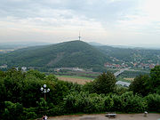
Weserbergland
Encyclopedia
Germany
Germany , officially the Federal Republic of Germany , is a federal parliamentary republic in Europe. The country consists of 16 states while the capital and largest city is Berlin. Germany covers an area of 357,021 km2 and has a largely temperate seasonal climate...
(Lower Saxony
Lower Saxony
Lower Saxony is a German state situated in north-western Germany and is second in area and fourth in population among the sixteen states of Germany...
, Hesse
Hesse
Hesse or Hessia is both a cultural region of Germany and the name of an individual German state.* The cultural region of Hesse includes both the State of Hesse and the area known as Rhenish Hesse in the neighbouring Rhineland-Palatinate state...
, and North Rhine-Westphalia
North Rhine-Westphalia
North Rhine-Westphalia is the most populous state of Germany, with four of the country's ten largest cities. The state was formed in 1946 as a merger of the northern Rhineland and Westphalia, both formerly part of Prussia. Its capital is Düsseldorf. The state is currently run by a coalition of the...
, between Hannoversch Münden and Porta Westfalica
Porta Westfalica
Porta Westfalica is a town in the district of Minden-Lübbecke, in North Rhine-Westphalia, Germany. The name “Porta Westfalica” is Latin and means “gate to Westphalia”. Coming from the north, the gorge is the entry to the region of Westphalia...
near the river Weser. Important cities of this region include Bad Karlshafen
Bad Karlshafen
Bad Karlshafen is a baroque, thermal salt spa town in the district of Kassel, in Hesse, Germany. It has 2300 inhabitants in the main ward of Bad Karlshafen, and a further 1900 in the medieval ward of Helmarshausen...
, Holzminden
Holzminden
Holzminden is a town in southern Lower Saxony, Germany. It is the capital of the district of Holzminden. It is located directly on the river Weser, which here is the border to North Rhine-Westphalia.-History:...
, Höxter
Höxter
Höxter is the seat of the Höxter district, and a town in eastern North Rhine-Westphalia on the left bank of the river Weser, 52 km north of Kassel in the centre of the Weser Uplands...
, Bodenwerder
Bodenwerder
Bodenwerder is a municipality in Holzminden district, Lower Saxony, Germany. It lies on the river Weser, upstream from Hamelin, at a point where the river has carved a gap in the hills...
, Hameln, Rinteln
Rinteln
Rinteln is a small town in Lower Saxony, Germany. It is located on the banks of the Weser river above the Porta Westfalica. Population: 28,500.It is accessed by the A2 autobahn .-History:...
, and Vlotho
Vlotho
Vlotho is a town in the district of Herford, in North Rhine-Westphalia, Germany.-Geography:Vlotho is located along the Weser river, south of the Wiehengebirge, bordering on the Ravensberger Hügelland in the west, Lipperland in the south, and the Weserbergland in the east...
. The tales of the Brothers Grimm
Brothers Grimm
The Brothers Grimm , Jacob Grimm and Wilhelm Grimm , were German academics, linguists, cultural researchers, and authors who collected folklore and published several collections of it as Grimm's Fairy Tales, which became very popular...
are set in the Weser Uplands, and it has many renaissance
Renaissance
The Renaissance was a cultural movement that spanned roughly the 14th to the 17th century, beginning in Italy in the Late Middle Ages and later spreading to the rest of Europe. The term is also used more loosely to refer to the historical era, but since the changes of the Renaissance were not...
buildings, exhibiting a peculiar regional style, the so-called Weser Renaissance
Weser Renaissance
Weser Renaissance is a form of Renaissance architectural style that is found in the area around the River Weser in central Germany and which has been well-preserved in the towns and cities of the region.- Background :...
style. The region roughly coincides with the natural region
Natural region
A Natural region is one which is distinguished by its natural features of geography and usually more important, geology. The natural ecology of the region is likely to be significant but one of these factors tends to influence the others....
of the Lower Saxon Hills
Lower Saxon Hills
The Lower Saxon Hills are one the 73 natural regions in Germany defined by the Federal Agency for Nature Conservation . Geographically it covers roughly the same area as the Weser Uplands in its wider sense....
defined by the Federal Agency for Nature Conservation
Federal Agency for Nature Conservation
The German Federal Agency for Nature Conservation is the German government’s scientific authority with responsibility for national and international nature conservation...
or BfN.
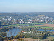
Geography
In addition to the whole of the Weser ValleyUpper Weser Valley
The Upper Weser Valley in central Germany has been formed by the Upper Weser river cutting through the Weser Uplands for around between the towns of Hann. Münden and Minden. It lies in the German federal states of Lower Saxony, Hesse and North Rhine-Westphalia.- Course :The Upper Weser Valley...
between Hann. Münden und Porta Westfalica, several geologically associated, but clearly separate chains of uplands, ridges and individual hills are considered part of the Weser Uplands. In its narrowest sense, the following would be included (running from north to south):
| Name | Height above NN |
|---|---|
| Wesergebirge Wesergebirge The Wesergebirge is a low mountain chain up to high in the Weser Uplands in the German states of North Rhine-Westphalia and Lower Saxony.... |
|
| Süntel Süntel The Süntel is a massif in the German Central Uplands that is up to . It forms part of the Weser Uplands in Lower Saxony southwest of Hanover and north of Hamelin.-Geographical location:... |
|
| Ottenstein Plateau Ottenstein Plateau The Ottenstein Plateau is part of the Lower Saxon Weser Uplands and lies between Bodenwerder and Bad Pyrmont.Compared with the surrounding area of the Weser and Emmer valleys, the plateau is a largely open plain, about 200 m higher, and which lies between 250 and 350 metres above sea level... |
ca. |
| Vogler | |
| Solling Solling The Solling is a range of hills up to high in the Weser Uplands in the German state of Lower Saxony, whose extreme southerly foothills extend into Hesse and North Rhine-Westphalia.... |
|
| Reinhardswald Reinhardswald The Reinhardswald is a range of hills up to and covering an area of over 200 km² in the Weser Uplands in the district of Kassel, Hesse... |
|
| Bramwald Bramwald The Bramwald is a range of hills up to in the Weser Uplands in Lower Saxony . It is a unique, natural, wild, hill and forest landscape... |
Notable ridges
In addition the following hills and ridges are often considered part of the Weser Hills:
|
Elfas The Elfas is a range of hills up to in the districts of Holzminden an Northeim in Lower Saxony .- Geographical location :The Elfas is located in the middle of the Leine Uplands between the Hils to the north, the Homburg Forest to the west, the Hube to the east, the Amtsberge to the south-southwest... Hils For HILS, see Hardware-in-the-loop simulation.The Hils is a range of hills in Germany's Central Uplands that is up to high. It is located in the districts of Holzminden, Hildesheim and Northeim, in the state of Lower Saxony.- Geography :... Homburg Forest The Homburg Forest also known as the Homburg Hills is an area of upland up to in the north German state of Lower Saxony.- Geography :... |
Ith The Ith is a ridge in Germany's Central Uplands which is up to high. It lies about 40 km southwest of Hanover and, at 22 kilometres, is the longest line of crags in North Germany.- Geography :- Location :... Kleiner Deister The Kleiner Deister is a ridge of hills in the Calenberg Uplands which, together with the Nesselberg and the Osterwald, forms a group of three adjacent hill ranges in the northern part of the Leine Uplands... Lippe Uplands The Lippe Uplands is a range of hills in Ostwestfalen-Lippe within the administrative district of Detmold in the German state of North Rhine-Westphalia.-Geography:... Nesselberg The Nesselberg is a ridge up to high in the Calenberg Highland which, together with the Kleiner Deister and the Osterwald, forms a group of three contiguous hill regions in the northwestern part of the Leine Uplands... |
Oberwälder Land The Oberwälder Land is a natural region in the extreme east of the German state of North Rhine-Westphalia with small elements parts in Hesse and Lower Saxony... Osterwald Osterwald is a community and part of the Joint Community of Neuenhaus in the district of Grafschaft Bentheim in Lower Saxony. The community consists of the centres of Osterwald, Alte Piccardie and Hohenkörben .... Ottenstein Plateau The Ottenstein Plateau is part of the Lower Saxon Weser Uplands and lies between Bodenwerder and Bad Pyrmont.Compared with the surrounding area of the Weser and Emmer valleys, the plateau is a largely open plain, about 200 m higher, and which lies between 250 and 350 metres above sea level... Weper The Weper is a long, high ridge of hills up to located in the district of Northeim in the German state of Lower Saxony.Part of the Weper is a nature reserve with the same name which, with an area of , is the large protected region of dry grassland in Lower Saxony.- Geography :The Weper, which lies... |
The landscape was most recently significantly formed during the course of the ice age
Ice age
An ice age or, more precisely, glacial age, is a generic geological period of long-term reduction in the temperature of the Earth's surface and atmosphere, resulting in the presence or expansion of continental ice sheets, polar ice sheets and alpine glaciers...
s by the advance of glacier
Glacier
A glacier is a large persistent body of ice that forms where the accumulation of snow exceeds its ablation over many years, often centuries. At least 0.1 km² in area and 50 m thick, but often much larger, a glacier slowly deforms and flows due to stresses induced by its weight...
s from the Scandinavia
Scandinavia
Scandinavia is a cultural, historical and ethno-linguistic region in northern Europe that includes the three kingdoms of Denmark, Norway and Sweden, characterized by their common ethno-cultural heritage and language. Modern Norway and Sweden proper are situated on the Scandinavian Peninsula,...
n ice sheets which gave rise to much of Germany's present-day Northern Lowlands.
Important towns
|
Dassel Dassel is a town in southern Lower Saxony, Germany, located in the district Northeim. It is located near the hills of the Solling mountains.-History:... Eschershausen Eschershausen is a municipality in the district of Holzminden, in Lower Saxony, Germany. It is situated approx. 20 km northeast of Holzminden, and 50 km south of Hanover.... Emmerthal Emmerthal is a municipality in the Hamelin-Pyrmont district, in Lower Saxony, Germany. It is situated on the river Weser, approximatively 6 km south of Hamelin. Its seat is in the village Kirchohsen.... Hann. Münden Hann. Münden is the German official name of a town in Lower Saxony, Germany. The city is located in the district of Göttingen at the confluence of the Fulda and Werra rivers, which join to form the river Weser. It has 28,000 inhabitants... Hessisch Oldendorf Hessisch Oldendorf is a town in the Hamelin-Pyrmont district, in Lower Saxony, Germany. It is situated on the river Weser, approx. 10 km northwest of Hamelin. The adjective "Hessisch" is used since 1905, to distinguish it from other towns named Oldendorf. Hessisch Oldendorf was part of... Holzminden Holzminden is a town in southern Lower Saxony, Germany. It is the capital of the district of Holzminden. It is located directly on the river Weser, which here is the border to North Rhine-Westphalia.-History:... Höxter Höxter is the seat of the Höxter district, and a town in eastern North Rhine-Westphalia on the left bank of the river Weser, 52 km north of Kassel in the centre of the Weser Uplands... |
Lemgo Lemgo is a city in the Lippe district of North Rhine-Westphalia, Germany, with a population of c. 42,000.It was founded in the 12th century by Bernhard II at the crossroad of two merchant routes. Lemgo was a member of the Hanseatic League, a medieval trading association of free cities in several... Minden Minden is a town of about 83,000 inhabitants in the north-east of North Rhine-Westphalia, Germany. The town extends along both sides of the river Weser. It is the capital of the Kreis of Minden-Lübbecke, which is part of the region of Detmold. Minden is the historic political centre of the... Porta Westfalica Porta Westfalica is a town in the district of Minden-Lübbecke, in North Rhine-Westphalia, Germany. The name “Porta Westfalica” is Latin and means “gate to Westphalia”. Coming from the north, the gorge is the entry to the region of Westphalia... Rinteln Rinteln is a small town in Lower Saxony, Germany. It is located on the banks of the Weser river above the Porta Westfalica. Population: 28,500.It is accessed by the A2 autobahn .-History:... Salzhemmendorf Salzhemmendorf is a village and a municipality in the Hamelin-Pyrmont district, in Lower Saxony, Germany. It is situated approx. 20 km east of Hamelin and 31 km west of Hildesheim and is located on the route 1... Bad Salzuflen Bad Salzuflen is a town in the Lippe district of North Rhine-Westphalia, Germany. At the end of 2006 it had 54415 inhabitants.-Details:Bad Salzuflen is a spa town and is known for its saltwater springs and thermal baths. In former times the town profited from the salt trade... Uslar Uslar is a town and a municipality in southern Lower Saxony, Germany, in the south-western part of the district of Northeim, and in the south of the hills of Solling forest which are part of the Weser Uplands.Uslar is located on the German Framework Road.... Vlotho Vlotho is a town in the district of Herford, in North Rhine-Westphalia, Germany.-Geography:Vlotho is located along the Weser river, south of the Wiehengebirge, bordering on the Ravensberger Hügelland in the west, Lipperland in the south, and the Weserbergland in the east... |