

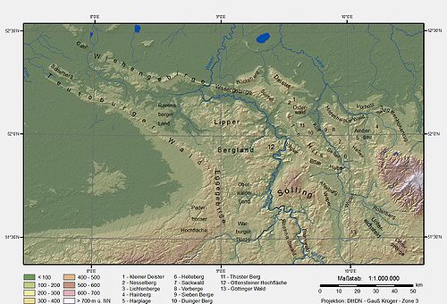
Solling
Encyclopedia
Lower Saxony
Lower Saxony is a German state situated in north-western Germany and is second in area and fourth in population among the sixteen states of Germany...
, whose extreme southerly foothills extend into Hesse
Hesse
Hesse or Hessia is both a cultural region of Germany and the name of an individual German state.* The cultural region of Hesse includes both the State of Hesse and the area known as Rhenish Hesse in the neighbouring Rhineland-Palatinate state...
and North Rhine-Westphalia
North Rhine-Westphalia
North Rhine-Westphalia is the most populous state of Germany, with four of the country's ten largest cities. The state was formed in 1946 as a merger of the northern Rhineland and Westphalia, both formerly part of Prussia. Its capital is Düsseldorf. The state is currently run by a coalition of the...
.
Inside Lower Saxony it is the second largest range of hills and the third highest after the Harz
Harz
The Harz is the highest mountain range in northern Germany and its rugged terrain extends across parts of Lower Saxony, Saxony-Anhalt and Thuringia. The name Harz derives from the Middle High German word Hardt or Hart , latinized as Hercynia. The legendary Brocken is the highest summit in the Harz...
(Wurmberg
Wurmberg (Harz)
At the Wurmberg is the second highest mountain in the Harz and the highest in Lower Saxony .- Geography :The Wurmberg lies north of Braunlage, in the district of Goslar, and west of Schierke. Its summit is located due south of the Brocken and roughly 400 m south of the state border with...
; ) and the Kaufungen Forest (Haferberg
Haferberg
The Haferberg is a hill, , in the Kaufungen Forest in Hesse and Lower Saxony in Germany.- Geography :The densely wooded Haferberg, which is the highest hill in the Münden Nature Park, is located on the border of north Hesse and south Lower Saxony , 1.25 km northwest of the pass of Umschwang,...
; ).
The Solling is a cultural landscape consisting mainly of spruce
Spruce
A spruce is a tree of the genus Picea , a genus of about 35 species of coniferous evergreen trees in the Family Pinaceae, found in the northern temperate and boreal regions of the earth. Spruces are large trees, from tall when mature, and can be distinguished by their whorled branches and conical...
and beech
Beech
Beech is a genus of ten species of deciduous trees in the family Fagaceae, native to temperate Europe, Asia and North America.-Habit:...
forests.Oak
Oak
An oak is a tree or shrub in the genus Quercus , of which about 600 species exist. "Oak" may also appear in the names of species in related genera, notably Lithocarpus...
also grows in some areas. Together with the smaller and lower Vogler range and the little Burgberg
Burgberg (ridge)
The Burgberg is a ridge of hills up to high in the German federal state of Lower Saxony.- Geography :The Burgberg, which belongs to the Solling-Vogler Nature Park, is located in the district of Holzminden in the Weser Uplands between the hill ranges of the Vogler to the north, the Homburgwald to...
to the north, the Solling is part of the Solling-Vogler Nature Park
Solling-Vogler Nature Park
The Solling-Vogler Nature Park is a nature park in South Lower Saxony in Germany. It has an area of and was established in 1966.The nature park includes the hill ranges of the Solling and the Vogler but also the Burgberg which lies east of Weser valley between the two upland regions...
.
Hills
The main hills in the Solling include the following (heights given in m above Normalnull):
|
|
Villages and towns
Villages and towns in the Solling are:
|
Hardegsen Hardegsen is a town in the district of Northeim, in Lower Saxony, Germany. It is situated approx. 15 km southwest of Northeim, and 15 km northwest of Göttingen.... Holzminden Holzminden is a town in southern Lower Saxony, Germany. It is the capital of the district of Holzminden. It is located directly on the river Weser, which here is the border to North Rhine-Westphalia.-History:... Höxter Höxter is the seat of the Höxter district, and a town in eastern North Rhine-Westphalia on the left bank of the river Weser, 52 km north of Kassel in the centre of the Weser Uplands... Lauenförde Lauenförde is a municipality in the district of Holzminden, in Lower Saxony, Germany.- ARMS :The arms were granted in 1927 and based on a seal of the Amt Lauenförde from 1779. The lion is the so-called Welfen-lion, indicating that the town belonged to this family. The waves symbolise the Weser... |
Nienover Nienover is a rural housing estate which is part of Bodenfelde. It is located in the Solling and contains one of the largest deserted medieval towns in northern Europe.- Local history :... Uslar Uslar is a town and a municipality in southern Lower Saxony, Germany, in the south-western part of the district of Northeim, and in the south of the hills of Solling forest which are part of the Weser Uplands.Uslar is located on the German Framework Road.... |
Literature
Johannes Krabbe: Karte des Sollings von 1603, herausgegeben und eingeleitet vonHans-Martin Arnoldt, Kirstin Casemir und Uwe Ohanski, Verlag Hahnsche Buchhandlung Hannover 2004.
External links
- http://www.solling.de
- http://www.hutewald.de
- http://www.hackelberg.de
- Wildpark Neuhaus (with forest museum)