

Ith
Encyclopedia
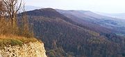
The Ith is a ridge in Germany's Central Uplands
which is up to high. It lies about 40 km southwest of Hanover
and, at 22 kilometres, is the longest line of crags in North Germany.
ridge in the Leine Uplands
. It runs in a northwest-southeast direction from Coppenbrügge
in the north to Holzen in the south. The highest elevation on this forested knife-edge ridge is the Lauensteiner Kopf at which has an observation tower, the Ithturm, and is located in the northern half of the Ith, the so-called Krüllbrink, between the villages of Bisperode and Lauenstein.
The streams on the Ith flow west via the Ilse, Remte and Lenne
into the Weser or east via the Saale into the Leine
.
The Ith is crossed by two roads: in the north by the L 425 between Haus Harderode and Lauenstein over the Lauenstein Pass, and in the south by the B 240 between Lüerdissen
and Capellenhagen over the Holzener Pass.
This hill, together with other summits, crags and foothills of the Ith are given below in order of their height in metres (m) above Normalnull (NN unless stated otherwise):
and Bulbous Corydalis
. There are several well-signed footpath
s on the Ith heights. The section from Bisperode to Holzen of European walking route E11
runs along the crest of the Ith.
There is a large number of striking rock formation
s (Klippen) along the Ith ridge, some of which may be used for climbing. These include the Lüerdissener Klippen that are up to 30 m high. As a result, the Ith is the busiest climbing area in the state of Lower Saxony. Almost all the rocks are named; examples include the Adam und Eva, the Kamel, the Teufelsküche ("Devil's Kitchen"), the Mönchstein ("Monk's Rock"), the 'Krötenkopf ("Frog's Head"), the Garwindelstein and many more besides.
At the southern end of the ridge, north of the parish of Holzen – reached over the Holzen Pass (B 240) – lies below the 395 m high Rothenstein the Ithwiesen Glider Airfield used by the aviation sports club of Ithwiesen.
There has been an airfield on the crest of the Ith since the early 1930s. In 1942 the Nazi leadership established the Ith Reichs Glider School in Holzen-Ith. Many pilots received their basic flying training there until the end of the war. After the war ended British occupation forces used the terrain as a "Rest Centre", a type of recreation centre. In 1949 the AHQ Gliding Club, to which up to 30 active pilots in the RAF
belonged, took over training on the site. In 1971 the first community service
school in Germany was established here, the Zivildienstschule I. The present glider airfield is located somewhat south east of the original one and no longer uses the old buildings. On 8 June 1979 a Bundeswehr helicopter of the Alouette II type crashed on landing on the Ith airfield. The pilot from the 12th Army Aviation Squadron (Heeresfliegerstaffel 12) and two accompanying soldiers of the 352nd Panzergrenadier Battalion (Panzergrenadierbataillon 352) were killed. Since 8 June 1987 there has been a monument on the Ith in their memory.
On the Ith, but not at the top, there are two other glider airfields: Hellenhagen Airfield in Halle-Bremke and Ith-West Airfield in Bisperode.
Central Uplands
The Central Uplands is one of the three major natural regions of Germany and covers most of the land area of the country. To the north lies the North German Plain or Northern Lowland; to the south, the Alps and the Alpine Foreland.- Formation :...
which is up to high. It lies about 40 km southwest of Hanover
Hanover
Hanover or Hannover, on the river Leine, is the capital of the federal state of Lower Saxony , Germany and was once by personal union the family seat of the Hanoverian Kings of Great Britain, under their title as the dukes of Brunswick-Lüneburg...
and, at 22 kilometres, is the longest line of crags in North Germany.
Geography
Location
The Ith is immediately northwest of the HilsHils
For HILS, see Hardware-in-the-loop simulation.The Hils is a range of hills in Germany's Central Uplands that is up to high. It is located in the districts of Holzminden, Hildesheim and Northeim, in the state of Lower Saxony.- Geography :...
ridge in the Leine Uplands
Leine Uplands
The Leine Uplands is a region in Germany's Central Uplands which forms a part of the Lower Saxon Hills and lies along the River Leine between Göttingen and Hanover...
. It runs in a northwest-southeast direction from Coppenbrügge
Coppenbrügge
Coppenbrügge is a municipality in the Hamelin-Pyrmont district, in Lower Saxony, Germany. It is situated approximatively 15 km east of Hamelin.The Municipality covers the following villages:* Bäntorf* Behrensen* Bessingen* Bisperode* * Coppenbrügge...
in the north to Holzen in the south. The highest elevation on this forested knife-edge ridge is the Lauensteiner Kopf at which has an observation tower, the Ithturm, and is located in the northern half of the Ith, the so-called Krüllbrink, between the villages of Bisperode and Lauenstein.
The streams on the Ith flow west via the Ilse, Remte and Lenne
Lenne
The Lenne is a river in the Sauerland area in North Rhine-Westphalia, western Germany, a left tributary of the Ruhr.Having its source on top of the Kahler Asten near Winterberg in an intermittent spring at an elevation of 2,687 feet, the Lenne ends after a course of 128 km flowing into the...
into the Weser or east via the Saale into the Leine
Leine
The Leine is a river in Thuringia and Lower Saxony, Germany. It is a left tributary of the Aller river and 281 km in length.The river's source is located close to the town of Leinefelde in Thuringia...
.
The Ith is crossed by two roads: in the north by the L 425 between Haus Harderode and Lauenstein over the Lauenstein Pass, and in the south by the B 240 between Lüerdissen
Lüerdissen
Lüerdissen is a municipality in the district of Holzminden, in Lower Saxony, Germany....
and Capellenhagen over the Holzener Pass.
Hills
The highest hill on the densely-forested Ith is the Lauensteiner Kopf at . It is located in the Krüllbrink, the name of the northern part of the Ith and has an observation tower, the Ith Tower.This hill, together with other summits, crags and foothills of the Ith are given below in order of their height in metres (m) above Normalnull (NN unless stated otherwise):
- Lauensteiner Kopf (ca. ), between Bisperode and Lauenstein; with the Ith Tower
- Hunzener Klippen (ca. ), near Hunzen
- Oberberg (ca. ), between CoppenbrüggeCoppenbrüggeCoppenbrügge is a municipality in the Hamelin-Pyrmont district, in Lower Saxony, Germany. It is situated approximatively 15 km east of Hamelin.The Municipality covers the following villages:* Bäntorf* Behrensen* Bessingen* Bisperode* * Coppenbrügge...
and Lauenstein; with the FalkensteinFalkensteinFalkenstein or Falckenstein is the name of several places and castles in Central Europe as well as a surname:- Places in Germany and Austria :* Falkenstein, Bavaria, district Cham...
natural monument - Rothestein (ca. ), near Holzen-Ith; with Ithwiesen Glider Airfield and near the Rothestein Cave
- Eggerser Berg (ca. ), between Bremke and Domäne Eggersen
- Hohenstein , between Lauenstein and Marienau
- Krähenberg (ca. ), near Lauenstein
- Dornbrink (ca. ), near Lauenstein
Sport and tourism
The Ith is a popular destination especially for hikers, climbers and glider pilots. The ridgeway draws many walkers especially in the springtime, when trees and flowers are blossoming, due to the distinctive stands of Wood AnemoneWood Anemone
Wood anemone is a common name for three closely related species of woodland anemone.In Europe: Anemone nemorosaIn North America: Anemone quinquefoliaThe Yellow wood anemone is Anemone ranunculoides....
and Bulbous Corydalis
Corydalis
Corydalis is a genus of about 470 species of annual and perennial herbaceous plants in the fumewort family , native to the temperate Northern Hemisphere and the high mountains of tropical eastern Africa...
. There are several well-signed footpath
Footpath
A Footpath is a thoroughfare intended for by pedestrians but not by motorized vehicles. The term is often for paths within an urban area that offer shorter quieter routes for pedestrians, they may also provide access to the surrounding countryside or parks...
s on the Ith heights. The section from Bisperode to Holzen of European walking route E11
European walking route E11
The E11 European long distance path or E11 path is one of the European long-distance paths, running 2500 km west-east from The Hague in the Netherlands through Germany and Poland....
runs along the crest of the Ith.
There is a large number of striking rock formation
Rock formation
This is a list of rock formations that include isolated, scenic, or spectacular surface rock outcrops. These formations are usually the result of weathering and erosion sculpting the existing rock...
s (Klippen) along the Ith ridge, some of which may be used for climbing. These include the Lüerdissener Klippen that are up to 30 m high. As a result, the Ith is the busiest climbing area in the state of Lower Saxony. Almost all the rocks are named; examples include the Adam und Eva, the Kamel, the Teufelsküche ("Devil's Kitchen"), the Mönchstein ("Monk's Rock"), the 'Krötenkopf ("Frog's Head"), the Garwindelstein and many more besides.
At the southern end of the ridge, north of the parish of Holzen – reached over the Holzen Pass (B 240) – lies below the 395 m high Rothenstein the Ithwiesen Glider Airfield used by the aviation sports club of Ithwiesen.
There has been an airfield on the crest of the Ith since the early 1930s. In 1942 the Nazi leadership established the Ith Reichs Glider School in Holzen-Ith. Many pilots received their basic flying training there until the end of the war. After the war ended British occupation forces used the terrain as a "Rest Centre", a type of recreation centre. In 1949 the AHQ Gliding Club, to which up to 30 active pilots in the RAF
Royal Air Force
The Royal Air Force is the aerial warfare service branch of the British Armed Forces. Formed on 1 April 1918, it is the oldest independent air force in the world...
belonged, took over training on the site. In 1971 the first community service
Community service
Community service is donated service or activity that is performed by someone or a group of people for the benefit of the public or its institutions....
school in Germany was established here, the Zivildienstschule I. The present glider airfield is located somewhat south east of the original one and no longer uses the old buildings. On 8 June 1979 a Bundeswehr helicopter of the Alouette II type crashed on landing on the Ith airfield. The pilot from the 12th Army Aviation Squadron (Heeresfliegerstaffel 12) and two accompanying soldiers of the 352nd Panzergrenadier Battalion (Panzergrenadierbataillon 352) were killed. Since 8 June 1987 there has been a monument on the Ith in their memory.
On the Ith, but not at the top, there are two other glider airfields: Hellenhagen Airfield in Halle-Bremke and Ith-West Airfield in Bisperode.
Literature
- Bundesanstalt für Landeskunde und Raumforschung: Geographische Landesaufnahme 1:200000. Naturräumliche Gliederung Deutschlands. Die naturräumlichen Einheiten auf Blatt 86 Hannover. Bad Godesberg 1960
- Hans-Jürgen Klink: Naturräumliche Gliederung des Ith-Hils-Berglandes. Bundesforschungsanstalt für Landeskunde und Raumforschung. 1966. ISBN B0000BS19H
- Friedmut Lehmeier: Regionale Geomorphologie des nördlichen Ith-Hils-Berglandes auf der Basis einer grossmaßstäbigen geomorphologischen Kartierung. Goltze Druck, Göttingen. 1981. ISBN 3-8845-2078-4
- Michael Geschwinde: Höhlen im Ith. Urgeschichtliche Opferstätten im südniedersächsischen Bergland. o.O. 1988. ISBN 3-7848-1233-3
- Richard Goedeke: Weser-Leine-Bergland. Verlag J. Berg, München. 1991. ISBN 3-7634-1049-x (zum Ith: S. 76–217)
- Ludger Feldmann, Hans Joachim Franzke, Rainer Müller: Die geologische Entwicklung der Tiefebene und der Mittelgebirge in Niedersachsen. (pdf) In: Veröffentlichungen der Akademie für Geowissenschaften zu Hannover. 20/2002. S. 8–19