

Tennessee State Route 67
Encyclopedia
State Route 67 is a state-maintained highway in northeastern Tennessee
, including a four-lane divided highway segments in both Washington County and Carter County
, and part of a significant two-lane segment passing over the Butler Bridge some 80 feet (24.4 m) above the TVA Watauga Reservoir
(also referred locally to as Watauga Lake
) near Butler
in Johnson County, Tennessee.
as part of Quad-Cities Beltway projects.
SR 67/Elk Avenue parallels the Watauga River
(to the left and north) before passing by a reconstructed interpretation of Fort Watauga
at Fort Sycamore Shoals State Park (the historical site of both the 1775 Transylvania Purchase
and also the later staging area of the Overmountain Men
defeated British Loyalists in South Carolina
during the 1780 Battle of Kings Mountain
) and the Sycamore Shoals Hospital (on the left) and moving more distantly away from the Watauga River. There are at least three usually busy local intersections with traffic signals found along this stretch of SR 67, including: Hudson Avenue (Wal-Mart on the left), Bemberg Road (Elizabethton High School on the right), and Mill Street (Krystal's on the left) before arriving at the Y-forked intersection with traffic signals where SR-67 leaves the remainder of Elk Avenue through the Elizabethton downtown business district.
 SR 67 veers about 45 degrees in direction toward the left at the Elk Avenue Y-fork as commercially developed segment that is locally referred to as Broad Street, with SR 67 passing through usually busy local intersections at North Roan Street (McDonald's on the left; also running into the Old Bristol Highway) and Sycamore Street (Taco John's on the left) before reaching the Broad Street Bridge in Elizabethton.
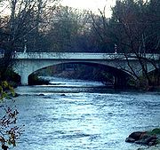
SR 67/Broad Street first passes over the Doe River
in Elizabethton on the circa 1926 concrete arch Broad Street bridge while continuing on as a four lane, and then SR 67 passes through the non-traffic signalled intersection of Main Street before turning south (right) with traffic signals from the next major intersection of Broad Street with U.S. Highway 19-E/SR 67 (and the Food City grocery store) and travelling again on south across the Doe River at the East Side bridges within Elizabethton.
Further on south, the four-laned highway runs closely paralleled with the Doe River (on the left), SR 67 starts gaining some gradual elevation and eventually crossing a section of bridges over the Doe River at the Valley Forge community just out side of the Elizabethton City limits (a left turn off SR 67 and onto Beck Moutanin Road after the first bridge is an alternative route to both the TVA Watauga Dam
and the TVA Wilbur Dam
).
SR 67 completes a final fourth and curving high double bridge crossings before arriving at Hampton.
hikers arriving or entering the "AT" at Hampton), and then exiting Hampton over a high ridge.
) and the Cherokee National Forest
. The TVA Watauga Dam
can be seen in the distance across the reservoir at the Rat Branch Boat Launch at SR67.
SR67 eventually passes over the TVA Watauga Reservoir at the 80 feet (24.4 m) high Butler Bridge before entering Johnson County.
East Tennessee
East Tennessee is a name given to approximately the eastern third of the U.S. state of Tennessee, one of the three Grand Divisions of Tennessee defined in state law. East Tennessee consists of 33 counties, 30 located within the Eastern Time Zone and three counties in the Central Time Zone, namely...
, including a four-lane divided highway segments in both Washington County and Carter County
Carter County, Tennessee
Carter County is a county located in the U.S. state of Tennessee. As of 2010, the population was 57,424. Its county seat is Elizabethton.Carter County is part of the Johnson City Metropolitan Statistical Area, which is a component of the Johnson City–Kingsport–Bristol, TN-VA Combined...
, and part of a significant two-lane segment passing over the Butler Bridge some 80 feet (24.4 m) above the TVA Watauga Reservoir
Tennessee Valley Authority
The Tennessee Valley Authority is a federally owned corporation in the United States created by congressional charter in May 1933 to provide navigation, flood control, electricity generation, fertilizer manufacturing, and economic development in the Tennessee Valley, a region particularly affected...
(also referred locally to as Watauga Lake
Watauga Lake
Watauga Lake, located southeast of Elizabethton, Tennessee, was created by the Tennessee Valley Authority with the completion of the TVA Watauga Dam and Reservoir....
) near Butler
Butler, Tennessee
Butler is an unincorporated community in Johnson County in the northeastern corner of the U.S. state of Tennessee. It is located near Watauga Lake. Butler is served by a post office, assigned ZIP Code 37640.-Early history:...
in Johnson County, Tennessee.
Washington County
In 1988, Tennessee State Route 67 was completed a freeway between Johnson City and ElizabethtonElizabethton, Tennessee
Elizabethton is the county seat of Carter County, Tennessee, United States. Elizabethton is also the historical site both of the first independent American government located west of both the Eastern Continental Divide and the original thirteen British American colonies.Elizabethton is also the...
as part of Quad-Cities Beltway projects.
Carter County
SR 67 enters in Carter County just past the Milligan Highway Exit at the Johnson City/Elizabethton city limits on a freeway four-lane segment. Traveling from Johnson City, this mostly unlighted freeway segment of SR 67 gains some modest elevation before finally rolling over a significant slope and finally arriving at cautioned marked sloped curve just before the freeway segment ends at the traffic signalled SR 362 Milligan Highway exit (near both the Elizabethton Municipal Golf Course and the Elizabethton Fire Department #3 Substation on the right).Elizabethton
At the SR 362/Milligan Highway exit, SR 67 continues on into Elizabethton as a four-lane down onto a mostly level and commercially developed segment (beginning at the junction SR 362 at Gap Creek Road) that is locally referred to as Elk Avenue. The City of Elizabethton itself mostly lies within two river valleys ringed by high mountains and significant hills.SR 67/Elk Avenue parallels the Watauga River
Watauga River
The Watauga River is a large stream of western North Carolina and East Tennessee. It is 60 miles long with its headwaters on the slopes of Grandfather Mountain and Peak Mountain in Watauga County, North Carolina.-Hydrography:...
(to the left and north) before passing by a reconstructed interpretation of Fort Watauga
Fort Watauga
Fort Watauga, more properly Fort Caswell, was an American Revolutionary War fort that once stood at the Sycamore Shoals of the Watauga River in what is now Elizabethton, Tennessee...
at Fort Sycamore Shoals State Park (the historical site of both the 1775 Transylvania Purchase
Transylvania (colony)
Transylvania, or the Transylvania Colony, was a short-lived, extra-legal colony founded in 1775 by Richard Henderson, who controlled the North Carolina based Transylvania Company, which had reached an agreement to purchase the land from the Cherokee in the "Treaty of Sycamore Shoals"...
and also the later staging area of the Overmountain Men
Overmountain Men
The Overmountain Men were American frontiersmen from west of the Appalachian Mountains who took part in the American Revolutionary War. While they were present at multiple engagements in the war's southern campaign, they are best known for their role in the American victory at the Battle of Kings...
defeated British Loyalists in South Carolina
South Carolina
South Carolina is a state in the Deep South of the United States that borders Georgia to the south, North Carolina to the north, and the Atlantic Ocean to the east. Originally part of the Province of Carolina, the Province of South Carolina was one of the 13 colonies that declared independence...
during the 1780 Battle of Kings Mountain
Battle of Kings Mountain
The Battle of Kings Mountain was a decisive battle between the Patriot and Loyalist militias in the Southern campaign of the American Revolutionary War...
) and the Sycamore Shoals Hospital (on the left) and moving more distantly away from the Watauga River. There are at least three usually busy local intersections with traffic signals found along this stretch of SR 67, including: Hudson Avenue (Wal-Mart on the left), Bemberg Road (Elizabethton High School on the right), and Mill Street (Krystal's on the left) before arriving at the Y-forked intersection with traffic signals where SR-67 leaves the remainder of Elk Avenue through the Elizabethton downtown business district.
SR 67/Broad Street first passes over the Doe River
Doe River
The Doe River is a naturally flowing river in northeast Tennessee that forms in Carter County near the North Carolina line, just south of Roan Mountain State Park.-Hydrography:...
in Elizabethton on the circa 1926 concrete arch Broad Street bridge while continuing on as a four lane, and then SR 67 passes through the non-traffic signalled intersection of Main Street before turning south (right) with traffic signals from the next major intersection of Broad Street with U.S. Highway 19-E/SR 67 (and the Food City grocery store) and travelling again on south across the Doe River at the East Side bridges within Elizabethton.
Further on south, the four-laned highway runs closely paralleled with the Doe River (on the left), SR 67 starts gaining some gradual elevation and eventually crossing a section of bridges over the Doe River at the Valley Forge community just out side of the Elizabethton City limits (a left turn off SR 67 and onto Beck Moutanin Road after the first bridge is an alternative route to both the TVA Watauga Dam
Watauga Dam
Watauga Dam is a hydroelectric and flood control dam on the Watauga River in Carter County, in the U.S. state of Tennessee. It is owned and operated by the Tennessee Valley Authority, which built the dam in the 1940s as part of efforts to control flooding in the Tennessee River watershed...
and the TVA Wilbur Dam
Wilbur Dam
Wilbur Dam is a hydroelectric dam on the Watauga River in Carter County, in the U.S. state of Tennessee. It is one of two dams on the river owned and operated by the Tennessee Valley Authority. The dam impounds Wilbur Lake, which extends for about up the Watauga to the base of Watauga Dam...
).
SR 67 completes a final fourth and curving high double bridge crossings before arriving at Hampton.
Hampton
At the small, mountainous community of Hampton, the four-laned SR 67 veers left off U.S. Highway 19-E and begins as a two-lane segment, briefly passing by commercial areas with Hampton (including a U.S. post office and a non-attended public vehicle parking area for Appalachian TrailAppalachian Trail
The Appalachian National Scenic Trail, generally known as the Appalachian Trail or simply the AT, is a marked hiking trail in the eastern United States extending between Springer Mountain in Georgia and Mount Katahdin in Maine. It is approximately long...
hikers arriving or entering the "AT" at Hampton), and then exiting Hampton over a high ridge.
Watauga Lake
Upon leaving Hampton, SR 67 again continually increases in elevation and roughly runs several miles parallel between both the shoreline of the massive TVA Watauga Reservoir (also known locally as Watauga LakeWatauga Lake
Watauga Lake, located southeast of Elizabethton, Tennessee, was created by the Tennessee Valley Authority with the completion of the TVA Watauga Dam and Reservoir....
) and the Cherokee National Forest
Cherokee National Forest
The Cherokee National Forest is a large National Forest created on July 19, 1936, by U.S. President Franklin Roosevelt, operated by the U.S. Forest Service and encompassing some 640,000 acres .-Location:...
. The TVA Watauga Dam
Watauga Dam
Watauga Dam is a hydroelectric and flood control dam on the Watauga River in Carter County, in the U.S. state of Tennessee. It is owned and operated by the Tennessee Valley Authority, which built the dam in the 1940s as part of efforts to control flooding in the Tennessee River watershed...
can be seen in the distance across the reservoir at the Rat Branch Boat Launch at SR67.
SR67 eventually passes over the TVA Watauga Reservoir at the 80 feet (24.4 m) high Butler Bridge before entering Johnson County.