

Washington Street (Boston)
Encyclopedia

Washington Street is a street originating in downtown Boston
Boston
Boston is the capital of and largest city in Massachusetts, and is one of the oldest cities in the United States. The largest city in New England, Boston is regarded as the unofficial "Capital of New England" for its economic and cultural impact on the entire New England region. The city proper had...
, Massachusetts
Massachusetts
The Commonwealth of Massachusetts is a state in the New England region of the northeastern United States of America. It is bordered by Rhode Island and Connecticut to the south, New York to the west, and Vermont and New Hampshire to the north; at its east lies the Atlantic Ocean. As of the 2010...
that extends southwestward to the Massachusetts
Massachusetts
The Commonwealth of Massachusetts is a state in the New England region of the northeastern United States of America. It is bordered by Rhode Island and Connecticut to the south, New York to the west, and Vermont and New Hampshire to the north; at its east lies the Atlantic Ocean. As of the 2010...
-Rhode Island
Rhode Island
The state of Rhode Island and Providence Plantations, more commonly referred to as Rhode Island , is a state in the New England region of the United States. It is the smallest U.S. state by area...
state line. The majority of it was built as the Norfolk and Bristol Turnpike in the early nineteenth century. It is the longest street in Boston, and it remains one of the longest streets in the state of Massachusetts.
Washington Street, as the first street that connected peninsular Boston to the mainland, serves as a divide where a number of cross streets change name.
Extent and description
Washington Street begins at Keany Square, the intersection with Causeway Street and Commercial Street, at the south end of the Charlestown BridgeCharlestown Bridge
The Charlestown Bridge is the easternmost bridge on the Charles River in Boston, Massachusetts. The bridge formerly carried the southernmost stretch of Massachusetts Route 99, which now ends at Chelsea Street in Charlestown. It connects to Joe Tecce Way to the south and to Rutherford Avenue to the...
. This section of the street is known as North Washington Street or Joe Tecce's Way. The road ends north of Haymarket Square
Haymarket Square (Boston)
Haymarket Square in Boston is an open-air fruit and vegetable market near the North End, Government Center, West End and Faneuil Hall Marketplace...
, where it joins the so-called Surface Artery (the road above the subterranean Big Dig
Big Dig
The Central Artery/Tunnel Project , known unofficially as the Big Dig and as the Big Dug since completion, was a megaproject in Boston that rerouted the Central Artery , the chief highway through the heart of the city, into a 3.5-mile tunnel...
.) Due to redevelopment, the original path of Washington Street has been pre-empted by Haymarket Square and Government Center (which used to be Scollay Square
Scollay Square
Scollay Square was a vibrant city square in downtown Boston, Massachusetts. It was named for William Scollay, a prominent local developer and militia officer who bought a landmark four-story merchant building at the intersection of Cambridge and Court Streets in 1795...
).
Washington Street begins once again at State and Court
Court Street (Boston, Massachusetts)
Court Street is located in the Financial District of Boston, Massachusetts. Prior to 1788, it was called Prison Lane and then Queen Street . In the 19th century it extended beyond its current length, to Bowdoin Square. In the 1960s most of Court Street was demolished to make way for the...
Streets as a one-way thoroughfare (for northbound traffic only). Through Downtown Crossing, from Milk Street south to Temple Place, Washington Street is closed to most vehicular traffic (and continues to be one-way northbound for authorized traffic only). South of Temple Place, Washington is, once again, one-way northbound, becoming two-way at Stuart Street and Kneeland Street. From Marginal Street, south to East Berkeley Street, including the bridge over the Massachusetts Turnpike and the adjacent Amtrak
Amtrak
The National Railroad Passenger Corporation, doing business as Amtrak , is a government-owned corporation that was organized on May 1, 1971, to provide intercity passenger train service in the United States. "Amtrak" is a portmanteau of the words "America" and "track". It is headquartered at Union...
/Massachusetts Bay Transit Authority (MBTA) commuter-railroad
MBTA Commuter Rail
The MBTA Commuter Rail serves as the regional rail arm of the Massachusetts Bay Transportation Authority, in the United States. It is operated under contract by the Massachusetts Bay Commuter Railroad Company a joint partnership of Veolia Transportation, Bombardier Transportation and Alternate...
tracks, the road is also one-way northbound, with a southbound contra-flowing bus lane for the Silver-Line
Silver Line (MBTA)
The Silver Line is the only bus rapid transit line currently operated by the Massachusetts Bay Transportation Authority . It operates in two sections; the first runs from Dudley Square in Roxbury to downtown Boston, Massachusetts and South Station, mostly via Washington Street, with buses...
bus.
At Dudley Square in Roxbury, Washington Street is southbound-only for several blocks, between Warren Street and Dudley Street. Northbound traffic bypasses this section to the east using those two streets. Just after passing under the Arborway in Jamaica Plain
Jamaica Plain, Massachusetts
Jamaica Plain is a historic neighborhood of in Boston, Massachusetts. Founded by Boston Puritans seeking farm land to the south, it was originally part of the city of Roxbury...
, Washington Street becomes Hyde Park Avenue, and traffic staying on Washington Street must turn west on Ukraine Way to cross over the Amtrak
Amtrak
The National Railroad Passenger Corporation, doing business as Amtrak , is a government-owned corporation that was organized on May 1, 1971, to provide intercity passenger train service in the United States. "Amtrak" is a portmanteau of the words "America" and "track". It is headquartered at Union...
/MBTA Commuter Rail
MBTA Commuter Rail
The MBTA Commuter Rail serves as the regional rail arm of the Massachusetts Bay Transportation Authority, in the United States. It is operated under contract by the Massachusetts Bay Commuter Railroad Company a joint partnership of Veolia Transportation, Bombardier Transportation and Alternate...
tracks, and then south at South Street, which becomes Washington Street again.
Southbound traffic must use short sections of South Street and Poplar Street at Roslindale Square. South of there, near the border between Roslindale and West Roxbury
West Roxbury, Massachusetts
West Roxbury is a neighborhood in Boston bordered by Roslindale to the north, the Town of Dedham to the east and south, the Town of Brookline and the City of Newton to the west. Many people mistakenly confuse West Roxbury with Roxbury, but the two are not connected. West Roxbury is separated from...
, Washington Street crosses West Roxbury Parkway and acquires a median strip. This median lasts until just before the Dedham
Dedham, Massachusetts
Dedham is a town in and the county seat of Norfolk County, Massachusetts, United States. The population was 24,729 at the 2010 census. It is located on Boston's southwest border. On the northwest it is bordered by Needham, on the southwest by Westwood and on the southeast by...
city line, where the road continues as an undivided road.
Washington Street continues southwestward, through the center of Dedham, the outskirts of Westwood
Westwood, Massachusetts
Westwood is a town in Norfolk County, Massachusetts, United States. The population was 14,618 at the 2010 census. In July 2005, CNN/Money and Money magazine ranked Westwood 13th on its list of the 100 Best Places to Live in the United States. Boston Magazine listed Gay Street in Westwood on its...
, the centers of Norwood
Norwood, Massachusetts
Norwood is a town and census-designated place in Norfolk County, Massachusetts, United States. As of the 2010 census, the population was 28,602. The community was named after Norwood, England...
, and East Walpole and South Walpole. At the Walpole
Walpole, Massachusetts
Walpole is a town in Norfolk County, Massachusetts, United States. It is located about south of Boston and north of Providence, Rhode Island. The population was 24,070 at the 2010 census. Walpole was first settled in 1659 and was considered a part of Dedham until officially incorporated in 1724...
-Foxborough
Foxborough, Massachusetts
-Demographics:As of the census of 2000, there were 16,246 people, 6,141 households, and 4,396 families residing in the town. The population density was 809.1 people per square mile . There were 6,299 housing units at an average density of 313.7 per square mile...
line, it no longer crosses the railroad tracks (the old Mansfield and Framingham Railroad
Mansfield and Framingham Railroad
The Mansfield and Framingham Railroad was a railroad in Massachusetts. It was incorporated in 1862 as the Foxborough Branch Railroad to provide a rail connection from Mansfield through Foxborough to Walpole...
), and traffic must detour via Water Street and North Street. North Street connects to the Boston-Providence Turnpike, which carries US Route 1
U.S. Route 1 in Massachusetts
In the U.S. state of Massachusetts, U.S. Route 1 is a major north–south state highway through Boston. The portion of US 1 south of Boston is also known as the Boston-Providence Turnpike, and portions north of the city are known as the Northeast Expressway and the Newburyport Turnpike.-Route...
(and was never actually a turnpike
Toll road
A toll road is a privately or publicly built road for which a driver pays a toll for use. Structures for which tolls are charged include toll bridges and toll tunnels. Non-toll roads are financed using other sources of revenue, most typically fuel tax or general tax funds...
, a toll road). This road merges into the old path of Washington Street south of the railroad. From there to Rhode Island
Rhode Island
The state of Rhode Island and Providence Plantations, more commonly referred to as Rhode Island , is a state in the New England region of the United States. It is the smallest U.S. state by area...
, except through North Attleborough
North Attleborough, Massachusetts
North Attleborough, commonly written North Attleboro, is a town in Bristol County, Massachusetts, United States. The population was 28,712 at the 2010 United States Census.The village of North Attleborough Center is located in the town.-History:...
center (which it bypasses using East Washington Street as opposed to North and South Washington Streets), US Route 1 stays with Washington, as it passes through the outskirts of Foxborough
Foxborough, Massachusetts
-Demographics:As of the census of 2000, there were 16,246 people, 6,141 households, and 4,396 families residing in the town. The population density was 809.1 people per square mile . There were 6,299 housing units at an average density of 313.7 per square mile...
(past Gillette Stadium
Gillette Stadium
Gillette Stadium is a multi-purpose stadium located in Foxborough, Massachusetts, 21 miles southwest of downtown Boston and from downtown Providence, Rhode Island. It serves as the home stadium and administrative offices for the New England Patriots football team and the New England Revolution...
), Wrentham
Wrentham, Massachusetts
Wrentham is a town in Norfolk County, Massachusetts, United States. The population was 10,955 at the 2010 census.- History :Wrentham was first settled by the English in 1660 and officially incorporated in 1673. It was burned down during King Philip's War 1675-1676. For a short time, it was the...
and Plainville
Plainville, Massachusetts
Plainville is a town in Norfolk County, Massachusetts, United States. The population as of the 2010 census was 8,264. Plainville is part of the Providence metropolitan area.- History :Plainville was originally a part of the town of Wrentham, Massachusetts...
, and then through South Attleboro
South Attleboro, Massachusetts
South Attleboro is a neighborhood of Attleboro, a city in Bristol County, Massachusetts, United States. It is perhaps best known for the South Attleboro station on the Attleboro/Stoughton Line of the MBTA Commuter Rail. U.S. 1 and Route 1A pass through the area, which lies just north of the Rhode...
.
History
The part of Washington Street between downtown Boston and Dudley SquareDudley Square
Dudley Square is the primary commercial center of the Roxbury neighborhood of Boston, Massachusetts, located at the intersection of Dudley Street and Washington Street...
in Roxbury was the first road connecting the small town of Boston to the mainland, carrying the Boston Post Road
Boston Post Road
The Boston Post Road was a system of mail-delivery routes between New York City and Boston, Massachusetts that evolved into the first major highways in the United States.The three major alignments were the Lower Post Road The Boston Post Road was a system of mail-delivery routes between New York...
to New York City
New York City
New York is the most populous city in the United States and the center of the New York Metropolitan Area, one of the most populous metropolitan areas in the world. New York exerts a significant impact upon global commerce, finance, media, art, fashion, research, technology, education, and...
. It was originally known by several names:
- Cornhill from Adams Square (now just south of Boston City HallBoston City HallBoston City Hall is the seat of the municipal government of Boston, Massachusetts. Architecturally, it is an example of the brutalist style. It was designed by Kallmann McKinnell & Knowles...
) south to School Street - Marlborough Street from School Street south to Summer StreetSummer Street (Boston)Summer Street in Boston, Massachusetts extends from Downtown Crossing in the Financial District, over Fort Point Channel, and into South Boston...
/Winter StreetWinter Street (Boston)Winter Street in Boston, Massachusetts is located between Tremont Street and Washington Street, near the Common. It is currently a pedestrian zone. Prior to 1708, it was called Blott's Lane and then Bannister's Lane.-See also:* Downtown Crossing... - Newbury Street from Summer Street/Winter Street south to Essex Street/Boylston StreetBoylston StreetBoylston Street is the name of a major east-west thoroughfare in the city of Boston, Massachusetts. Another Boylston Street runs through Boston's western suburbs....
- Orange Street from Essex Street/Boylston Street south to the fortificationFortificationFortifications are military constructions and buildings designed for defence in warfare and military bases. Humans have constructed defensive works for many thousands of years, in a variety of increasingly complex designs...
near East Berkeley Street (then Dover Street)
On July 4, 1788, the road south of the fortification, to the line with Roxbury, was given the name Washington Street. The name was extended north to Adams Square on July 6, 1824, and north on a new road to Haymarket Square
Haymarket Square (Boston)
Haymarket Square in Boston is an open-air fruit and vegetable market near the North End, Government Center, West End and Faneuil Hall Marketplace...
on November 6, 1872.
The part north of Roxbury Street in Dudley Square, Roxbury was laid out as a public way on January 19, 1662, and given its name May 9, 1825. Additionally, the Washington Street name went west on Roxbury Street, Tremont Street
Tremont Street
Tremont Street is a major thoroughfare in Boston, Massachusetts.-Etymology:The name is a variation of one of the original appellations of the city, "Trimountaine," a reference to a hill that formerly had three peaks. Beacon Hill, with its single peak, is all that remains of the Trimountain...
and Huntington Avenue
Huntington Avenue (Boston)
Huntington Avenue is a secondary thoroughfare in the city of Boston, Massachusetts beginning at Copley Square, and continuing west through the Back Bay, Fenway, Longwood, and Mission Hill neighborhoods...
(the path of the Boston Post Road
Boston Post Road
The Boston Post Road was a system of mail-delivery routes between New York City and Boston, Massachusetts that evolved into the first major highways in the United States.The three major alignments were the Lower Post Road The Boston Post Road was a system of mail-delivery routes between New York...
) to the border with Brookline (which still has a Washington Street as an extension of this one).
The Norfolk and Bristol Turnpike was established in 1803, and built as a turnpike as a straighter alternate to two roads between Boston and Providence - the Lower Boston Post Road
Boston Post Road
The Boston Post Road was a system of mail-delivery routes between New York City and Boston, Massachusetts that evolved into the first major highways in the United States.The three major alignments were the Lower Post Road The Boston Post Road was a system of mail-delivery routes between New York...
(via Norwood
Norwood, Massachusetts
Norwood is a town and census-designated place in Norfolk County, Massachusetts, United States. As of the 2010 census, the population was 28,602. The community was named after Norwood, England...
and Foxborough
Foxborough, Massachusetts
-Demographics:As of the census of 2000, there were 16,246 people, 6,141 households, and 4,396 families residing in the town. The population density was 809.1 people per square mile . There were 6,299 housing units at an average density of 313.7 per square mile...
) and the road via Walpole
Walpole, Massachusetts
Walpole is a town in Norfolk County, Massachusetts, United States. It is located about south of Boston and north of Providence, Rhode Island. The population was 24,070 at the 2010 census. Walpole was first settled in 1659 and was considered a part of Dedham until officially incorporated in 1724...
and Wrentham
Wrentham, Massachusetts
Wrentham is a town in Norfolk County, Massachusetts, United States. The population was 10,955 at the 2010 census.- History :Wrentham was first settled by the English in 1660 and officially incorporated in 1673. It was burned down during King Philip's War 1675-1676. For a short time, it was the...
. It ran from Dudley Square
Dudley Square
Dudley Square is the primary commercial center of the Roxbury neighborhood of Boston, Massachusetts, located at the intersection of Dudley Street and Washington Street...
to the Rhode Island
Rhode Island
The state of Rhode Island and Providence Plantations, more commonly referred to as Rhode Island , is a state in the New England region of the United States. It is the smallest U.S. state by area...
line and beyond to downtown Pawtucket. Coincidentally the only part not built as a new road was the part through North Attleborough
North Attleborough, Massachusetts
North Attleborough, commonly written North Attleboro, is a town in Bristol County, Massachusetts, United States. The population was 28,712 at the 2010 United States Census.The village of North Attleborough Center is located in the town.-History:...
that US 1
U.S. Route 1 in Massachusetts
In the U.S. state of Massachusetts, U.S. Route 1 is a major north–south state highway through Boston. The portion of US 1 south of Boston is also known as the Boston-Providence Turnpike, and portions north of the city are known as the Northeast Expressway and the Newburyport Turnpike.-Route...
now bypasses.
The southern half of the turnpike got little use as it avoided all the towns, where travelers wanted to stop, and had some steep grades. In fact, until the 1930s, when the current highway (part of US 1) was built between Boston and Providence, the southern half remained a dirt road
Dirt road
Dirt road is a common term for an unpaved road made from the native material of the land surface through which it passes, known to highway engineers as subgrade material. Dirt roads are suitable for vehicles; a narrower path for pedestrians, animals, and possibly small vehicles would be called a...
.
The part of the turnpike in Roxbury was laid out as a public road in June 1857. It was named Shawmut Avenue, as an extension of that road from Dudley Square. The portion in West Roxbury
West Roxbury, Massachusetts
West Roxbury is a neighborhood in Boston bordered by Roslindale to the north, the Town of Dedham to the east and south, the Town of Brookline and the City of Newton to the west. Many people mistakenly confuse West Roxbury with Roxbury, but the two are not connected. West Roxbury is separated from...
was named Shawmut Avenue February 3, 1858.
On July 2, 1860, Tremont Street was extended west from its former south end along former Washington Street to Brookline
Brookline, Massachusetts
Brookline is a town in Norfolk County, Massachusetts, United States, which borders on the cities of Boston and Newton. As of the 2010 census, the population of the town was 58,732.-Etymology:...
, and Washington Street now ended at Columbus Street (then Pynchon Street). The rest of the road west from Dudley Square became Roxbury Street on June 16, 1874, and at the same time Washington Street was extended south from Dudley Square along the former Shawmut Street to the line with Dedham
Dedham, Massachusetts
Dedham is a town in and the county seat of Norfolk County, Massachusetts, United States. The population was 24,729 at the 2010 census. It is located on Boston's southwest border. On the northwest it is bordered by Needham, on the southwest by Westwood and on the southeast by...
.
South from downtown Dedham
Dedham, Massachusetts
Dedham is a town in and the county seat of Norfolk County, Massachusetts, United States. The population was 24,729 at the 2010 census. It is located on Boston's southwest border. On the northwest it is bordered by Needham, on the southwest by Westwood and on the southeast by...
, the turnpike went not via the current Washington Street, but via School Street and Court Street.
The part of Washington Street north of Haymarket Square
Haymarket Square (Boston)
Haymarket Square in Boston is an open-air fruit and vegetable market near the North End, Government Center, West End and Faneuil Hall Marketplace...
was known as Charlestown Street until around 1900.
The first state highway
State highway
State highway, state road or state route can refer to one of three related concepts, two of them related to a state or provincial government in a country that is divided into states or provinces :#A...
in Boston was the part of Washington Street from Dedham to West Roxbury Parkway (at Lagrange Street). It was taken over by the Massachusetts Department of Public Works in 1908. The short piece in West Roxbury Parkway, to just north of the road through the parkway, was taken over in 1921; the next state highway in Boston was the Southern Artery
Southern Artery
Southern Artery is a street in Quincy, Massachusetts. For much of its length it is a major arterial street which is used by an average of over 30,000 Boston area commuters daily.-History:...
in 1926.
Public transportation
As a main road, Washington Street has had its share of streetcar and later busBus
A bus is a road vehicle designed to carry passengers. Buses can have a capacity as high as 300 passengers. The most common type of bus is the single-decker bus, with larger loads carried by double-decker buses and articulated buses, and smaller loads carried by midibuses and minibuses; coaches are...
routes. It also had the Washington Street Elevated
Washington Street Elevated
The Washington Street Elevated was an elevated segment of Boston's Massachusetts Bay Transportation Authority subway system, comprising the southern stretch of the Orange Line . It ran from Chinatown through the South End and Roxbury, ending in Forest Hills in Jamaica Plain...
from south of downtown to Dudley and later Forest Hills
Forest Hills (MBTA station)
Forest Hills Station is a station on the MBTA Orange Line, located in Forest Hills in the southern part of the Jamaica Plain neighborhood of Boston, Massachusetts at the intersections of Washington Street, Hyde Park Avenue, South Street, The Arborway and Morton Street.Forest Hills is the southern...
.
An 1871 map shows streetcar tracks from Boylston Street
Boylston Street
Boylston Street is the name of a major east-west thoroughfare in the city of Boston, Massachusetts. Another Boylston Street runs through Boston's western suburbs....
south to Dudley Street. An 1874 map extends them south from Dudley to just north of Forest Hills
Forest Hills (MBTA station)
Forest Hills Station is a station on the MBTA Orange Line, located in Forest Hills in the southern part of the Jamaica Plain neighborhood of Boston, Massachusetts at the intersections of Washington Street, Hyde Park Avenue, South Street, The Arborway and Morton Street.Forest Hills is the southern...
, and north to Dock Square
Dock Square (Boston, Massachusetts)
Dock Square in Boston, Massachusetts is a public square adjacent to Faneuil Hall, bounded by Congress Street, North Street, and Union Street. Its name derives from its original location at the waterfront. From the 1630s through the early 19th-century, it served boats in the Boston Harbor as "the...
. By 1888, tracks also used Washington north to Haymarket Square
Haymarket Square (Boston)
Haymarket Square in Boston is an open-air fruit and vegetable market near the North End, Government Center, West End and Faneuil Hall Marketplace...
, and by 1897 all the way to and over the Charlestown Bridge
Charlestown Bridge
The Charlestown Bridge is the easternmost bridge on the Charles River in Boston, Massachusetts. The bridge formerly carried the southernmost stretch of Massachusetts Route 99, which now ends at Chelsea Street in Charlestown. It connects to Joe Tecce Way to the south and to Rutherford Avenue to the...
.
On an 1899 map, tracks owned by the West Roxbury and Roslindale Street Railway continued southwest from Forest Hills via Dedham
Dedham, Massachusetts
Dedham is a town in and the county seat of Norfolk County, Massachusetts, United States. The population was 24,729 at the 2010 census. It is located on Boston's southwest border. On the northwest it is bordered by Needham, on the southwest by Westwood and on the southeast by...
to Norwood
Norwood, Massachusetts
Norwood is a town and census-designated place in Norfolk County, Massachusetts, United States. As of the 2010 census, the population was 28,602. The community was named after Norwood, England...
. The Norfolk Southern Street Railway left Norfolk on the road to Walpole
Walpole, Massachusetts
Walpole is a town in Norfolk County, Massachusetts, United States. It is located about south of Boston and north of Providence, Rhode Island. The population was 24,070 at the 2010 census. Walpole was first settled in 1659 and was considered a part of Dedham until officially incorporated in 1724...
center, but used Washington Street from Common Street in Walpole to South Walpole. Except for the older section through North Attleborough
North Attleborough, Massachusetts
North Attleborough, commonly written North Attleboro, is a town in Bristol County, Massachusetts, United States. The population was 28,712 at the 2010 United States Census.The village of North Attleborough Center is located in the town.-History:...
center, used by the Interstate Consolidated Street Railway, none of the rest had streetcar tracks, due to its avoidance of populated areas.
A 1925 map still has streetcar tracks on Washington Street within Boston, ending downtown at Essex Street. By 1953 they were only in use from Forest Hills
Forest Hills (MBTA station)
Forest Hills Station is a station on the MBTA Orange Line, located in Forest Hills in the southern part of the Jamaica Plain neighborhood of Boston, Massachusetts at the intersections of Washington Street, Hyde Park Avenue, South Street, The Arborway and Morton Street.Forest Hills is the southern...
to Egleston (by the 40 route, bus substituted December 18, 1955) and from Dudley to Northampton Street (by the 47 route, bustituted September 13, 1953, and the 10 route, bus substituted December 5, 1953).
The Washington Street Elevated
Washington Street Elevated
The Washington Street Elevated was an elevated segment of Boston's Massachusetts Bay Transportation Authority subway system, comprising the southern stretch of the Orange Line . It ran from Chinatown through the South End and Roxbury, ending in Forest Hills in Jamaica Plain...
, later part of the Orange Line
Orange Line (MBTA)
The Orange Line is one of the four subway lines of the Massachusetts Bay Transportation Authority. It extends from Forest Hills in Jamaica Plain, Boston in the south to Oak Grove in Malden, Massachusetts in the north. It meets the Red Line at Downtown Crossing, the Blue Line at State, and the Green...
, opened from south of downtown Boston to Dudley on June 10, 1901, and south to Forest Hills
Forest Hills (MBTA station)
Forest Hills Station is a station on the MBTA Orange Line, located in Forest Hills in the southern part of the Jamaica Plain neighborhood of Boston, Massachusetts at the intersections of Washington Street, Hyde Park Avenue, South Street, The Arborway and Morton Street.Forest Hills is the southern...
November 22, 1909. The Washington Street Tunnel downtown opened November 30, 1908. The Elevated closed on April 30, 1987, with the opening of the Southwest Corridor
Southwest Corridor
The Southwest Corridor or Southwest Expressway was a project designed to bring an eight-lane highway into the City of Boston from a direction southwesterly of downtown. It was supposed to connect with Interstate 95 at Route 128...
several days later.
Numbered routes
Washington Street currently has the following numbers:- Route 1AMassachusetts Route 1ARoute 1A is a south–north state highway in Massachusetts. It is an alternate route to U.S. 1 with three signed sections and two unsigned sections where the highway is concurrent with its parent...
from Elm Street in Dedham south to the split with Walpole Street in Norwood (except in northern Norwood, where 1A uses Upland Road) - US 1 from northern FoxboroughFoxborough, Massachusetts-Demographics:As of the census of 2000, there were 16,246 people, 6,141 households, and 4,396 families residing in the town. The population density was 809.1 people per square mile . There were 6,299 housing units at an average density of 313.7 per square mile...
near Gillette StadiumGillette StadiumGillette Stadium is a multi-purpose stadium located in Foxborough, Massachusetts, 21 miles southwest of downtown Boston and from downtown Providence, Rhode Island. It serves as the home stadium and administrative offices for the New England Patriots football team and the New England Revolution...
to Rhode IslandRhode IslandThe state of Rhode Island and Providence Plantations, more commonly referred to as Rhode Island , is a state in the New England region of the United States. It is the smallest U.S. state by area...
, except through North AttleboroughNorth Attleborough, MassachusettsNorth Attleborough, commonly written North Attleboro, is a town in Bristol County, Massachusetts, United States. The population was 28,712 at the 2010 United States Census.The village of North Attleborough Center is located in the town.-History:...
center, where US 1 uses East Washington Street
When the first numbered highways in Massachusetts, the New England Interstate Highways, were assigned in 1922, NE 1
U.S. Route 1 in Massachusetts
In the U.S. state of Massachusetts, U.S. Route 1 is a major north–south state highway through Boston. The portion of US 1 south of Boston is also known as the Boston-Providence Turnpike, and portions north of the city are known as the Northeast Expressway and the Newburyport Turnpike.-Route...
used Washington Street through North Attleborough center and from Norwood center to Arborway in Boston. By 1927, US 1 (as the road was now known) split in Dedham
Dedham, Massachusetts
Dedham is a town in and the county seat of Norfolk County, Massachusetts, United States. The population was 24,729 at the 2010 census. It is located on Boston's southwest border. On the northwest it is bordered by Needham, on the southwest by Westwood and on the southeast by...
center onto Court Street, using Ames Street and Bridge Street into Boston, where it used Spring Street and Centre Street to reach Arborway.
Soon after 1933, the new road (Boston-Providence Turnpike and Brook Farm Parkway) from Roslindale to Foxborough was finished, and it was around this time that the rest of the current alignment to Rhode Island was finished — using Washington Street from Foxborough to the state line, except through North Attleborough center. The old road became Route 1A
Massachusetts Route 1A
Route 1A is a south–north state highway in Massachusetts. It is an alternate route to U.S. 1 with three signed sections and two unsigned sections where the highway is concurrent with its parent...
north from Attleborough center and through South Attleboro
South Attleboro, Massachusetts
South Attleboro is a neighborhood of Attleboro, a city in Bristol County, Massachusetts, United States. It is perhaps best known for the South Attleboro station on the Attleboro/Stoughton Line of the MBTA Commuter Rail. U.S. 1 and Route 1A pass through the area, which lies just north of the Rhode...
, ending at the rotary just north of Dedham center. For several years in between, the new road was only built south of Dedham, and US 1 once again used Washington Street from Dedham into West Roxbury
West Roxbury, Massachusetts
West Roxbury is a neighborhood in Boston bordered by Roslindale to the north, the Town of Dedham to the east and south, the Town of Brookline and the City of Newton to the west. Many people mistakenly confuse West Roxbury with Roxbury, but the two are not connected. West Roxbury is separated from...
, where it cut north to Centre Street via West Roxbury Parkway.
Between 1949 and 1961, 1A was truncated to end at US 1 via Elm Street south of Dedham center, probably to keep traffic out of Dedham center. US 1 was removed from that alignment in 1989, but 1A still ends at the old route.
Other Washington Streets in Boston
There are two other significant and two minor streets with the same name in Boston.- In the Dorchester neighborhood, Washington Street extends approximately 2.8 miles (4.5 km) from Blue Hill Avenue near Geneva Avenue to Dorchester Avenue at the southern boundary of the city.
- In Allston-BrightonAllston-BrightonAllston-Brighton is a set of two interlocking Boston neighborhoods, Allston and Brighton.-Geographical and technical Issues:Allston and Brighton's border runs along Everett Street in the North, running south along Gordon Street and terminates at the Brookline town line along Kelton Street...
, Washington Street begins at the boundary with BrooklineBrookline, MassachusettsBrookline is a town in Norfolk County, Massachusetts, United States, which borders on the cities of Boston and Newton. As of the 2010 census, the population of the town was 58,732.-Etymology:...
and extends about 2 miles (3.2 km) to the boundary with NewtonNewton, MassachusettsNewton is a city in Middlesex County, Massachusetts, United States bordered to the east by Boston. According to the 2010 U.S. Census, the population of Newton was 85,146, making it the eleventh largest city in the state.-Villages:...
near Burton Street. As a whole, it begins in Brookline Village, and crosses Brookline, Allston, Brighton, Newton, and WellesleyWellesley, MassachusettsWellesley is a town in Norfolk County, Massachusetts, United States. It is part of Greater Boston. The population was 27,982 at the time of the 2010 census.It is best known as the home of Wellesley College and Babson College...
, ending at Wellesley's boundary with NatickNatick, MassachusettsNatick is a town in Middlesex County, Massachusetts, United States. Natick is located near the center of the MetroWest region of Massachusetts, with a population of 33,006 at the 2010 census. Only west from Boston, Natick is considered part of the Greater Boston area...
, a total of almost 13.5 miles (21.7 km). It is the main east-west street in Allston-Brighton. - In Hyde Park, Washington Street extends approximately seven blocks in the small portion of Hyde Park on the east side of the Neponset RiverNeponset RiverThe Neponset River is a river in eastern Massachusetts in the United States. The headwaters of the Neponset are at the Neponset Reservoir in Foxborough, near the Gillette Stadium...
. - In Charlestown, Washington Street begins at a dead end near the intersection of Austin Street and New Rutherford Avenue and extends three blocks to Harvard Street. This is two blocks from the north end of the Charlestown BridgeCharlestown BridgeThe Charlestown Bridge is the easternmost bridge on the Charles River in Boston, Massachusetts. The bridge formerly carried the southernmost stretch of Massachusetts Route 99, which now ends at Chelsea Street in Charlestown. It connects to Joe Tecce Way to the south and to Rutherford Avenue to the...
and three blocks from the beginning of the Washington Street that is the subject of this article.
See also
- Downtown CrossingDowntown CrossingDowntown Crossing is a shopping district in Boston, Massachusetts, located due east of Boston Common and west of the Financial District. It features large department stores as well as restaurants, music stores, souvenir sellers, general retail establishments, and many street vendors...
- Boston-area streetcar linesBoston-area streetcar linesAs with many large cities, a large number of Boston-area streetcar lines once existed. However, only a few remain, namely the four branches of the Green Line and the Ashmont-Mattapan High Speed Line, with only one running regular service on an undivided street.The Massachusetts Bay Transportation...
- Modern Theatre (Boston)Modern Theatre (Boston)The Modern Theatre on Washington Street in Boston, Massachusetts was first opened in 1876 as the Dobson Building, designed by Levi Newcomb. It was renovated in 1914 as a movie theatre by architect Clarence Blackall; by 1980 it had fallen into neglect and dilapidation...
- Old Corner BookstoreOld Corner BookstoreThe Old Corner Bookstore is a historic building in the center of Boston, Massachusetts. It is located at the corner of Washington and School Streets, along the Freedom Trail of revolutionary and early American historic sites.-History:...
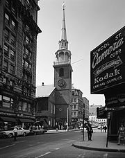
- Old South Meeting HouseOld South Meeting HouseThe Old South Meeting House , in the Downtown Crossing area of Boston, Massachusetts, gained fame as the organizing point for the Boston Tea Party on December 16, 1773. 5,000 colonists gathered at the Meeting House, the largest building in Boston at the time.-Church :The church, with its 56 m ...
- Pie Alley (Boston)Pie Alley (Boston)Pie Alley or Pi Alley in Boston, Massachusetts, is located off Washington Street, near the Old City Hall on School Street. The origin of the short street's nickname remains in question...
Former tenants
- Amory Hall (Boston)Amory Hall (Boston)Amory Hall was located on the corner of Washington Street and West Street in Boston, Massachusetts in the 19th-century. Myriad activities took place in the rental hall, including sermons; lectures by Henry David Thoreau, Ralph Waldo Emerson, William Lloyd Garrison; political meetings; exhibitions...
, 19th c. - Boston Female AsylumBoston Female AsylumThe Boston Female Asylum was an orphanage in Boston, Massachusetts, "for the care of indigent girls." Its mission was to "receive ... protect ... and instruct ... female orphans until the age of 10 years, when they are placed in respectable families."-History:The Asylum incorporated in 1803....
- Boylston MarketBoylston MarketBoylston Market , designed by architect Charles Bulfinch, was located in Boston, Massachusetts, on the corner of Boylston and Washington Streets. Boylston Hall occupied the third floor of the building, and functioned as a performance and meeting space.-History:The Boylston Market Association...
- Chinese Museum (Boston)Chinese Museum (Boston)The Chinese Museum in Boston, Massachusetts showed to the public some 41 cases displaying approximately 800 objects related to Chinese fine arts, agriculture, costume, and other customs. It was located on Washington Street in the Marlboro Chapel Items exhibited included:* "Long-gans...
, 19th c. - Fetridge & Co.William Pembroke FetridgeWilliam Pembroke Fetridge was a travel writer, publisher, bookseller and periodicals distributor. He lived in the Boston, Massachusetts area and in Paris, France.- Brief biography :...
, periodical depot, 19th c.
- S.S. KilburnSamuel Smith KilburnSamuel Smith Kilburn was an engraver in Boston, Massachusetts, in the 19th-century. He trained with Abel Bowen. Kilburn's work appeared in popular periodicals such as Gleason's Pictorial. His business partners included Richard P. Mallory and Henry C. Cross...
, engraver, 19th c. - Liberty TreeLiberty TreeThe Liberty Tree was a famous elm tree that stood in Boston near Boston Common, in the days before the American Revolution. Ten years before the American Revolution, colonists in Boston staged the first act of defiance against the British government at the tree...
- MelodeonMelodeon (Boston, Massachusetts)The Melodeon was a concert hall and performance space in 19th-century Boston, Massachusetts, located on Washington Street, near West Street...
, 19th c. - White, Smith & CompanyWhite, Smith & CompanyWhite, Smith & Company was a music publishing firm in Boston, Massachusetts. It issued numerous sheet music titles and a monthly journal, Folio. In 1897 in became the "White-Smith Music Publishing Company."-History:...
, music publishers, 19th c. - Whipple'sJohn Adams WhippleJohn Adams Whipple was an American inventor and early photographer. He was the first in the United States to manufacture the chemicals used for daguerreotypes; he pioneered astronomical and night photography; he was a prize-winner for his extraordinary early photographs of the moon; and he was the...
photo studio, 19th c. - White Horse Tavern (Boston, Massachusetts)White Horse Tavern (Boston, Massachusetts)The White Horse was a tavern on Washington Street in Boston, Massachusetts in the 17th and 18th centuries. A well-known gathering place in colonial Boston, it "had a large square sign projecting over the footway, on which was delineated a white charger." Located near Boylston Street, the White...
Further reading
- Edwin Monroe Bacon. Washington Street, old and new: a history in narrative form of the changes which this ancient street has undergone since the settlement of Boston. Boston: Macullar Parker Co., 1913.