

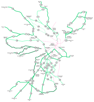
Boston-area streetcar lines
Encyclopedia
Green Line (MBTA)
The Green Line is a streetcar system run by the Massachusetts Bay Transportation Authority in the Boston, Massachusetts area of the United States. It is the oldest line of Boston's subway, which is known locally as the 'T'. The Green Line runs underground downtown and on the surface in outlying...
and the Ashmont-Mattapan High Speed Line
Ashmont-Mattapan High Speed Line
The Ashmont–Mattapan High Speed Line or also known as the "M-Line" in Boston and Milton, Massachusetts is considered to be part of the MBTA's Red Line, even though it uses different equipment and passengers have to change at Ashmont. The only MBTA line to run through a cemetery, the line opened on...
, with only one (the Green Line "E" Branch) running regular service on an undivided street.
The Massachusetts Bay Transportation Authority
Massachusetts Bay Transportation Authority
The Massachusetts Bay Transportation Authority, often referred to as the MBTA or simply The T, is the public operator of most bus, subway, commuter rail and ferry systems in the greater Boston, Massachusetts, area. Officially a "body politic and corporate, and a political subdivision" of the...
(MBTA) was formed on August 3, 1964, taking over operations from the Metropolitan Transit Authority (MTA). The MTA itself was formed in 1947 to take over operations of the private Boston Elevated Railway
Boston Elevated Railway
The Boston Elevated Railway was a precursor first to the Metropolitan Transit Authority in Massachusetts, now the Massachusetts Bay Transportation Authority, operating rapid transit, streetcars and buses in the Boston, Massachusetts area. It was formerly known as the West End Street Railway.The...
(BERy), which ran rapid transit
Rapid transit
A rapid transit, underground, subway, elevated railway, metro or metropolitan railway system is an electric passenger railway in an urban area with a high capacity and frequency, and grade separation from other traffic. Rapid transit systems are typically located either in underground tunnels or on...
, streetcar
Tram
A tram is a passenger rail vehicle which runs on tracks along public urban streets and also sometimes on separate rights of way. It may also run between cities and/or towns , and/or partially grade separated even in the cities...
s and bus
Bus
A bus is a road vehicle designed to carry passengers. Buses can have a capacity as high as 300 passengers. The most common type of bus is the single-decker bus, with larger loads carried by double-decker buses and articulated buses, and smaller loads carried by midibuses and minibuses; coaches are...
es in the Boston area.
In 1936, the BERy assigned numbers to its routes for map use, but route numbers were not used on buses until the late 1960s (when the colors were assigned to the remaining rail lines). http://groups-beta.google.com/group/misc.transport.urban-transit/browse_frm/thread/8e9826e370694dbd/ece73ce9d301d519 Additionally, the numbers were only kept the same on and after the 1942 revision of the map; before that they were changed with each new version. A few routes were renumbered around 1967, but most routes have kept their original numbers. Routes were numbered roughly clockwise from South Boston to East Boston
East Boston, Massachusetts
East Boston is a neighborhood of Boston, Massachusetts, with approximately 40,000 residents. The community was created by connecting several islands using landfill and was annexed by Boston in 1836. East Boston is separated from the rest of the city by Boston Harbor and bordered by Winthrop,...
.
This is a table of when each streetcar line was converted to trackless trolley
Trolleybus
A trolleybus is an electric bus that draws its electricity from overhead wires using spring-loaded trolley poles. Two wires and poles are required to complete the electrical circuit...
or bus
Bus
A bus is a road vehicle designed to carry passengers. Buses can have a capacity as high as 300 passengers. The most common type of bus is the single-decker bus, with larger loads carried by double-decker buses and articulated buses, and smaller loads carried by midibuses and minibuses; coaches are...
. Only information post-1940 is complete.
| Routes: | 4/Green Line "D" 7 9 10 11 15 16 17 19 20 22 23 25 26 27 28/Red Line Mattapan 29 30 30A/28 32 34 36 39/Green Line "E" (Arborway) 40 41 42 43 44 45 47/1 48 57/Green Line "E" (Heath) 58 60 61/Green Line "C" 62/Green Line "B" 65 66 69/Green Line "A"/57 70 71 72 73 76 77/69 79/77 80 82/77A 87 88 89 92 93 100 101 111 114 115 116 117 118 119 121 122 |
|---|
| Last day of streetcars | Route | Notes |
|---|---|---|
| Still operational | Riverside - Subway | Renamed Green Line "D" Branch ca. 1967 |
| Mattapan - Ashmont High Speed Line | Number dropped and considered part of Red Line Red Line (MBTA) The Red Line is a rapid transit line operated by the MBTA running roughly north-south through Boston, Massachusetts into neighboring communities. The line begins west of Boston, in Cambridge, Massachusetts at Alewife station, near the intersection of Alewife Brook Parkway and Route 2... ca. 1967, still runs 1940s-era PCC streetcar PCC streetcar The PCC streetcar design was first built in the United States in the 1930s. The design proved successful in its native country, and after World War II was licensed for use elsewhere in the world... . |
|
| Heath Street - Subway | Renamed Green Line "E" Branch (short-turn) ca. 1967 | |
| Cleveland Circle - Subway | Renamed Green Line "C" Branch ca. 1967 | |
| Boston College - Subway | Renamed Green Line "B" Branch ca. 1967 | |
| December 27, 1985 | Arborway - Subway | Renamed Green Line "E" Branch ca. 1967, reverted to 39 |
| June 20, 1969 | Watertown - Subway | Renamed Green Line "A" Branch ca. 1967, reverted to 57 |
| October 28, 1963 | New configuration of downtown subway opens | |
| April 5, 1962 | Shuttle Pleasant Street - Boylston | Last service to the Pleasant Street Incline Pleasant Street Incline The Pleasant Street Incline or Pleasant Street Portal was the southern access point for the Tremont Street Subway in Boston, Massachusetts, which later became part of the Green Line .-History:... |
| November 17, 1961 | Lenox Street - Subway | Closed June 14, 1956 from Egleston to Lenox Street |
| July 4, 1959 | Riverside - Subway (Highland Branch) opens | |
| September 4, 1958 | Watertown - Harvard | Still trackless trolley |
| Waverly - Harvard | Still trackless trolley | |
| North Cambridge - Harvard | Renumbered ca. 1967 Still trackless trolley |
|
| June 14, 1956 | Egleston - Subway | Cut back to Lenox Street |
| December 16, 1955 | Arborway - Egleston | |
| Elm Street - Sullivan | truncated to Elm Street in 1946 http://206.103.49.193/boston/htm/bvb040.htm | |
| November 18, 1955 | Arlington Heights - Harvard | Renumbered ca. 1967 |
| September 9, 1955 | Mattapan - Egleston | |
| January 19, 1954 | Revere Extension opens to Wonderland Wonderland (MBTA station) Wonderland is the northern terminus of the Blue Line in the Massachusetts Bay Transportation Authority mass transit system serving greater Boston. The station is located near the site of the now-closed Wonderland Greyhound Park in Revere, Massachusetts, and is handicapped accessible. See MBTA... |
|
| December 4, 1953 | City Point - Dudley | |
| September 12, 1953 | Mass Station - Dudley | Renumbered ca. 1967 |
| June 19, 1953 | City Point - South Station | |
| April 24, 1953 | Mattapan - Roslindale | |
| Mattapan - Arborway | Renumbered ca. 1967 | |
| Cleary Square - Arborway | Trackless trolley until September 30, 1958 | |
| March 1, 1953 | City Point - Subway | Bus connected to subway shuttle at Pleasant Street Incline Pleasant Street Incline The Pleasant Street Incline or Pleasant Street Portal was the southern access point for the Tremont Street Subway in Boston, Massachusetts, which later became part of the Green Line .-History:... through December 4, 1953 http://groups-beta.google.com/group/misc.transport.urban-transit/msg/85c7e0d89f6d90e5 |
| November 21, 1952 | Dedham Line - Arborway | Trackless trolley until September 5, 1958 |
| April 21, 1952 | Revere Extension opens to Suffolk Downs Suffolk Downs (MBTA station) Suffolk Downs is a station on the Massachusetts Bay Transportation Authority's Blue Line, which runs between Bowdoin station, near Beacon Hill in Boston, and the Wonderland station in Revere, Massachusetts... |
|
| January 5, 1952 | Revere Extension opens to Orient Heights Orient Heights (MBTA station) Orient Heights is a station on the MBTA Blue Line in East Boston, MA. It is located on the above-ground section of the line that uses overhead lines instead of third rail.... |
|
| January 4, 1952 | Meridian - Maverick | Turned around at the south end of the closed Meridian Street Bridge Trackless trolley until March 30, 1961 (Woodlawn - Maverick, via the Meridian Street Bridge, reopened ca. 1954) |
| Gladstone - Maverick | Short-turn of 118 | |
| Revere Beach Loop - Maverick via Revere Street | Trackless trolley until September 8, 1961 (Wonderland - Wood Island) | |
| Revere Beach Loop - Maverick via Beach Street | Trackless trolley until September 8, 1961 (Wonderland - Wood Island) | |
| Revere Carhouse - Maverick via Ocean Avenue and Bennington Street | Trackless trolley until June 1955 (Wonderland - Orient Heights) | |
| Eagle Carhouse - Maverick via Lexington | Trackless trolley until March 30, 1961 (Wood Island - Maverick) | |
| September 28, 1951 | Charles River - Arborway | Trackless trolley until September 5, 1958 |
| June 16, 1950 | Watertown - Central | Trackless trolley until March 30, 1963 |
| December 9, 1949 | Franklin Park - Andrew | Trackless trolley until April 5, 1962 |
| September 18, 1949 | Harvard - Mass Station | Trackless trolley until March 30, 1960 |
| September 16, 1949 | Egleston - Dudley | |
| July 1, 1949 | Sullivan - Subway via Bunker Hill Street | |
| June 7, 1949 | Jamaica Plain - Dudley | |
| April 23, 1949 | Jefferies Point - Maverick | |
| February 11, 1949 | Fields Corner - Andrew via Meeting House Hill | Trackless trolley until April 5, 1962 |
| January 28, 1949 | Seaver - Dudley | Trackless trolley until March 30, 1961 |
| January 7, 1949 | Fields Corner - Dudley via Geneva Avenue | Trackless trolley until April 5, 1962 |
| Ashmont-Dudley via Talbot Avenue | Trackless trolley until April 5, 1962 | |
| Ashmont-Dudley via Washington Street, Dorchester | Trackless trolley until April 6, 1962 | |
| December 24, 1948 | Uphams Corner - Dudley | Trackless trolley until April 5, 1962 (Kane Square - Dudley) |
| Grove Hall - Dudley via Blue Hill Avenue | Trackless trolley until April 5, 1962 | |
| June 18, 1948 | Fields Corner - Neponset | Trackless trolley until March 30, 1961 |
| April 2, 1948 | Sullivan - Subway via Main Street | |
| April 18, 1947 | Salem Street - Sullivan via Winter Hill | Trackless trolley until March 13, 1959 |
| December 6, 1946 | Clarendon Hill - Sullivan | Trackless trolley until March 29, 1963 |
| November 7, 1941 | Clarendon Hill - Lechmere via Somerville Avenue | Trackless trolley until March 29, 1963 Ran into the Subway via Lechmere Lechmere (MBTA station) Lechmere is the northern terminus of the MBTA Green Line. It is located in Lechmere Square in East Cambridge, Massachusetts, near the intersection of Cambridge Street and Monsignor O'Brien Highway . The tracks make a loop at Lechmere, with a small yard... until July 9, 1922 |
| Clarendon Hill - Lechmere via Highland Avenue | Trackless trolley until March 29, 1963 Ran into the Subway via Lechmere Lechmere (MBTA station) Lechmere is the northern terminus of the MBTA Green Line. It is located in Lechmere Square in East Cambridge, Massachusetts, near the intersection of Cambridge Street and Monsignor O'Brien Highway . The tracks make a loop at Lechmere, with a small yard... until July 9, 1922 |
|
| February 16, 1941 | Huntington Avenue Subway opens, ending and service on eastern Huntington Avenue and Boylston Street, and service through the Boylston Street Incline | |
| September 9, 1938 | Allston - Dudley http://groups-beta.google.com/group/misc.transport.urban-transit/msg/85c7e0d89f6d90e5 | |
| Brookline Village - Subway | Rush-hour only truncation of / (?) from 1932 Cut back to Brigham Circle Brigham Circle (MBTA station) Brigham Circle is a trolley-train stop on the "E" branch of the MBTA's Green Line in Boston, MA. Along with the Longwood Station, it is the closest stop to Harvard Medical School, the Harvard School of Public Health and the rest of the Longwood Medical and Academic Area, all of which are within a... short-turns |
|
| April 1, 1938 | Huron Avenue - Harvard via Concord Avenue | Still trackless trolley |
| March 4, 1938 | Dudley - Subway | Ran via Washington Street, Dover and Tremont Streets into the Subway Replaced by Dudley - Tremont & Dover Streets bus Bus service ended February 1942 http://groups-beta.google.com/group/misc.transport.urban-transit/msg/85c7e0d89f6d90e5 |
| May 7, 1937 | Woodlawn - Chelsea Square http://groups-beta.google.com/group/misc.transport.urban-transit/browse_frm/thread/3959ff3a9189e504/06dc72c5e42ca2f1 http://groups-beta.google.com/group/misc.transport.urban-transit/msg/85c7e0d89f6d90e5 | Extended to City Square as a bus |
| October 9, 1936 | Beachmont - Revere City Hall http://groups-beta.google.com/group/misc.transport.urban-transit/msg/85c7e0d89f6d90e5 | |
| June 10, 1936 | Eastern Massachusetts Street Railway Eastern Massachusetts Street Railway The Eastern Massachusetts Street Railway was a streetcar and later bus company in eastern Massachusetts, serving most suburbs of Boston, Massachusetts... Chelsea Chelsea, Massachusetts Chelsea is a city in Suffolk County, Massachusetts, United States directly across the Mystic River from the city of Boston. It is the smallest city in Massachusetts in land area, and the 26th most densely populated incorporated place in the country.-History:... division (routes - ) bought by BERy; some of these had run into the subway until 1935 http://groups-beta.google.com/group/misc.transport.urban-transit/msg/85c7e0d89f6d90e5 |
|
| April 10, 1936 | Harvard - Lechmere via Cambridge Street http://groups-beta.google.com/group/misc.transport.urban-transit/msg/85c7e0d89f6d90e5 | Renumbered ca. 1967 Trackless trolley until March 30, 1963 (first trackless trolley route) Ran into the Subway via Lechmere Lechmere (MBTA station) Lechmere is the northern terminus of the MBTA Green Line. It is located in Lechmere Square in East Cambridge, Massachusetts, near the intersection of Cambridge Street and Monsignor O'Brien Highway . The tracks make a loop at Lechmere, with a small yard... until July 9, 1922 |
| 1933 | Ashmont - Milton? | Replaced with Ashmont - Mattapan bus? |
| October 23, 1932 | Kenmore Kenmore (MBTA station) Kenmore is an MBTA light rail station in the Kenmore Square area of Boston, Massachusetts, and serves the Green Line B, C, and D branches... station opens, with a dual-pronged extension of the Boylston Street Subway |
|
| July 8, 1932 | Arlington Center - Sullivan via Medford Hillside http://groups-beta.google.com/group/misc.transport.urban-transit/msg/85c7e0d89f6d90e5 | Replaced with Arlington Center - Lechmere bus, later trackless trolley until March 28, 1963 http://groups-beta.google.com/group/rec.railroad/browse_frm/thread/e7eaa59acbc1c855/633ea88566d3a6b5 Streetcar line opened August 31, 1901 |
| 1932 | Cypress Street - Mass Station or Subway? http://groups-beta.google.com/group/misc.transport.urban-transit/msg/85c7e0d89f6d90e5 | Replaced with Cypress Street - Kenmore bus Brookline Village - Subway kept rush hours only |
| Chestnut Hill - Mass Station or Subway? http://groups-beta.google.com/group/misc.transport.urban-transit/msg/85c7e0d89f6d90e5 | Replaced with Chestnut Hill - Kenmore bus Brookline Village - Subway kept rush hours only |
|
| 1930 | Dorchester Avenue http://world.nycsubway.org/us/boston/red/mbta-red-andrew.html | |
| ca. 1930 | Eastern Massachusetts Street Railway Eastern Massachusetts Street Railway The Eastern Massachusetts Street Railway was a streetcar and later bus company in eastern Massachusetts, serving most suburbs of Boston, Massachusetts... Hyde Park Hyde Park, Massachusetts Hyde Park is a dissolved municipality and currently the southernmost neighborhood of Boston, Massachusetts, United States. Hyde Park is home to a diverse range of people, housing types and social groups. It is an urban location with suburban characteristics... and Chelsea Chelsea, Massachusetts Chelsea is a city in Suffolk County, Massachusetts, United States directly across the Mystic River from the city of Boston. It is the smallest city in Massachusetts in land area, and the 26th most densely populated incorporated place in the country.-History:... /Everett Everett, Massachusetts Everett is a city in Middlesex County, Massachusetts, United States, near Boston. The population was 41,667 at the 2010 census.Everett is the last city in the United States with a bicameral legislature, which is composed of a seven-member Board of Aldermen and an 18-member Common Council... divisions sold to BERy http://groups-beta.google.com/group/rec.railroad/msg/89d182695f2550e5?hl=en |
|
| December 21, 1929 | (Ashmont-Mattapan High Speed Line Ashmont-Mattapan High Speed Line The Ashmont–Mattapan High Speed Line or also known as the "M-Line" in Boston and Milton, Massachusetts is considered to be part of the MBTA's Red Line, even though it uses different equipment and passengers have to change at Ashmont. The only MBTA line to run through a cemetery, the line opened on... ) opens to Mattapan Mattapan (MBTA station) Mattapan or Mattapan Sq. is the southern terminus of the Ashmont-Mattapan High Speed Line in Boston, Massachusetts. It is in the Mattapan neighborhood of Boston. The station is a major transfer facility, served by several bus lines.- Reconstruction :... |
|
| August 26, 1929 | (Ashmont-Mattapan High Speed Line Ashmont-Mattapan High Speed Line The Ashmont–Mattapan High Speed Line or also known as the "M-Line" in Boston and Milton, Massachusetts is considered to be part of the MBTA's Red Line, even though it uses different equipment and passengers have to change at Ashmont. The only MBTA line to run through a cemetery, the line opened on... ) opens to Milton Milton, Massachusetts Milton is a town in Norfolk County, Massachusetts, United States and part of the Greater Boston area. The population was 27,003 at the 2010 census. Milton is the birthplace of former U.S. President George H. W. Bush and architect Buckminster Fuller. Milton also has the highest percentage of... |
|
| January 18, 1929 | Broadway? - Bay View http://groups-beta.google.com/group/ne.transportation/browse_frm/thread/6f18544af28bb4c4/2bdcda5d1782d1b9 | |
| late 1928 or early 1929 | Dudley - Nelson & Norfolk Streets http://world.nycsubway.org/us/boston/red/mbta-red-ashmont.html | Replaced with Ashmont - Morton & Corbett Streets bus |
| late 1928 | Andrew - Washington Washington Street (Boston) Washington Street is a street originating in downtown Boston, Massachusetts that extends southwestward to the Massachusetts-Rhode Island state line. The majority of it was built as the Norfolk and Bristol Turnpike in the early nineteenth century... & Fairmount Streets http://world.nycsubway.org/us/boston/red/mbta-red-ashmont.html |
Replaced with Ashmont - Washington Street & Gallivan Boulevard bus |
| September 1, 1928 | Dorchester Extension Red Line (MBTA) The Red Line is a rapid transit line operated by the MBTA running roughly north-south through Boston, Massachusetts into neighboring communities. The line begins west of Boston, in Cambridge, Massachusetts at Alewife station, near the intersection of Alewife Brook Parkway and Route 2... opens to Ashmont Ashmont (MBTA station) Ashmont is located on the Red Line in Dorchester, Massachusetts. It opened on September 1, 1928, and is the subway terminal for the Red Line's Dorchester Branch. Ashmont is also the terminus of the light rail Ashmont–Mattapan High Speed Line, which loops around on an elevated viaduct... |
|
| November 5, 1927 | Dorchester Extension Red Line (MBTA) The Red Line is a rapid transit line operated by the MBTA running roughly north-south through Boston, Massachusetts into neighboring communities. The line begins west of Boston, in Cambridge, Massachusetts at Alewife station, near the intersection of Alewife Brook Parkway and Route 2... opens to Fields Corner Fields Corner (MBTA station) Fields Corner is a station on the rapid transit Red Line at Fields Corner in Dorchester, Massachusetts. It opened on November 5, 1927, serving as the south end of the line for about a year... |
|
| April 17, 1924 | Last day of streetcars through the East Boston Tunnel | |
| July 9, 1922 | Last day of lines entering the subway via Lechmere Lechmere (MBTA station) Lechmere is the northern terminus of the MBTA Green Line. It is located in Lechmere Square in East Cambridge, Massachusetts, near the intersection of Cambridge Street and Monsignor O'Brien Highway . The tracks make a loop at Lechmere, with a small yard... |
|
| 1920s | Boston College - Brookline Village http://groups-beta.google.com/group/misc.transport.urban-transit/browse_frm/thread/c2b09f61a4c43e83/d4d1a39bca41e0fd | |
| 1920s | Sullivan - Dudley via Subway http://groups-beta.google.com/group/misc.transport.urban-transit/msg/85c7e0d89f6d90e5 | |
| March 15, 1919 | Charlestown Elevated Charlestown Elevated The Charlestown Elevated was a former link of Boston's Orange Line rapid transit line that ran from a portal at North Station, near the old Boston Garden, to the city of Everett, Massachusetts... opens to Everett Everett, Massachusetts Everett is a city in Middlesex County, Massachusetts, United States, near Boston. The population was 41,667 at the 2010 census.Everett is the last city in the United States with a bicameral legislature, which is composed of a seven-member Board of Aldermen and an 18-member Common Council... |
|
| ca. 1919 | Harvard Square - Jeffries Point via East Boston Tunnel http://groups-beta.google.com/group/misc.transport.urban-transit/messages/6d649feb19b5f47d,956032b9553bb428,a0033dacbcb4bf6a,f6a23a8c84260980,c7b81e4d266be9c7,f93b18fe60ac8370,0da65bb8af68e929,2cf5b1540883111a,43b8f9e89f312593,f1e0f1cfedbcc160?hl=en&thread_id=a39e96e4ecc836ca&mode=thread&noheader=1&_done=%2Fgroup%2Fmisc.transport.urban-transit%2Fbrowse_frm%2Fthread%2Fa39e96e4ecc836ca%2Fa9a23545f09a35c6%3F#doc_956032b9553bb428] | unknown | Fields Corner - Adams Street | Merged with September 1962 Was trackless trolley? |
| Arlington Center - Clarendon Hill | Merged with October 1961 Split off into 81 Arlington Center - Lechmere April 1953 Renumbered ca. 1967 Trackless trolley until March 29, 1963 |
|
| Davis Square - Sullivan via Highland Avenue | Trackless trolley until November 14, 1956 | |
| Malden - Faulkner via Main Street and Cross Street | Trackless trolley until March 28, 1963 | |
| Malden - Everett via Main Street | Discontinued April 1962 Was trackless trolley |
|
| Malden - Everett via Ferry Street and Broadway | Trackless trolley until March 29, 1963 | |
| Faulkner - Everett via Cross Street and Main Street | Trackless trolley until March 29, 1963 | |
| Lebanon Street - Everett via Salem Street, Malden Square and Main Street | Trackless trolley until March 29, 1963 | |
| Linden - Everett via Broadway | Trackless trolley until March 29, 1963 | |
| Wonderland or Broadway and Park Avenue - Everett via Everett Square | Trackless trolley until March 29, 1963 | |
| Eagle Carhouse - City Square via Chelsea Square | Was trackless trolley? | |
| Malden Square - Chelsea Square via Everett Square | Trackless trolley until June 23, 1961 | |
| Malden Square - Chelsea Square via Ferry Street | Trackless trolley until December 8, 1960; the route was discontinued | |
| Wonderland - Malden via Ferry Street | Unnumbered until ca. 1962 Trackless trolley summers 1954-1956 |
|
| Orient Heights - Maverick via Bennington Street | Trackless trolley until September 8, 1961 | |
See also
- Middlesex and Boston Street RailwayMiddlesex and Boston Street RailwayThe Middlesex and Boston Street Railway was a streetcar and later bus company in the area west of Boston, Massachusetts. Streetcars last ran in 1930, and in 1972 the company's operations were merged into the Massachusetts Bay Transportation Authority .-History:The company was first chartered as...
- Eastern Massachusetts Street RailwayEastern Massachusetts Street RailwayThe Eastern Massachusetts Street Railway was a streetcar and later bus company in eastern Massachusetts, serving most suburbs of Boston, Massachusetts...