
Washington State Route 262
Encyclopedia
State Route 262 is a state route in the U.S. state
of Washington.
. It travels north for a few miles before turning east and passing by Potholes State Park. After this, it passes just south of Potholes Reservoir
, crossing the O'Sullivan Dam
. The terminus is then at State Route 17
.
U.S. state
A U.S. state is any one of the 50 federated states of the United States of America that share sovereignty with the federal government. Because of this shared sovereignty, an American is a citizen both of the federal entity and of his or her state of domicile. Four states use the official title of...
of Washington.
Route description
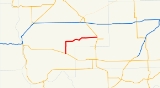
Route 262 begins at State Route 26 northwest of OthelloOthello, Washington
Othello is a city in Adams County, Washington, United States. The population was 5,847 at the 2000 census and grew 25.9% over the next decade to 7,364 at the 2010 census. Othello refers to the city as being in the "Heart" of the Columbia Basin Project...
. It travels north for a few miles before turning east and passing by Potholes State Park. After this, it passes just south of Potholes Reservoir
PotHoles Reservoir
The Potholes Reservoir is part of the Columbia Basin Irrigation Project. It is formed by the O'Sullivan Dam and located in central Washington, in the United States. The reservoir is fed by water from Moses Lake, part of the Crab Creek basin....
, crossing the O'Sullivan Dam
O'Sullivan Dam
O'Sullivan Dam, one of the larger earthfill dams in the United States , is on Crab Creek in the U.S. state of Washington, about 45 km south of Ephrata and 25 km south of Moses Lake...
. The terminus is then at State Route 17
State Route 17 (Washington)
State Route 17 is a highway in the state of Washington, U.S.A. It extends about from U.S. Route 395 in the tiny town of Mesa, in the south central part of the state, to U.S. Route 97 at the confluence of the Okanogan and Columbia Rivers near Brewster....
.