

Washington County, Arkansas
Encyclopedia
Washington County is a county
located in the northwest part of the U.S. state
of Arkansas
. As of 2010, the population was 203,065. The county seat
is Fayetteville
. Washington County is Arkansas's 17th county, formed on October 17, 1828, and named for George Washington
, the first President of the United States
. Washington County is part of the Fayetteville-Springdale-Rogers, AR-MO Metropolitan Statistical Area
.
was centrally located in the city of Washington, modern-day Fayetteville
(renamed to avoid confusion with Washington, Arkansas
in South Arkansas
). The Lee Creek Valley in south Washington county contained many of the county's early settlements, including Cane Hill
and Evansville
.
Arkansas College and Cane Hill College
were both founded in Washington County within a day of each other in 1834, with the University of Arkansas
being founded in Fayetteville in 1834. The county witnessed many Civil War
battles, including the Battle of Fayetteville
, the Battle of Prairie Grove
, and the Battle of Cane Hill
. Many area residents had northern sympathies, slavery was not prominent, plantations were rare and the source of information at the time was from White River
travelers, not the more-southern Arkansas River
. The Butterfield Overland Mail
route was established through the area in 1858, bringing many westbound families to settle in Washington County.
The economy of Washington County was based upon apples in the late 19th century. A good mixture of wet weather, altitude, and loamy soils formed a great environment for apple orchards. First forming in areas around Lincoln
, Evansville
, and Cane Hill
in the 1830s, apple orchards began to form all across the county. The United States Census
reported a crop of 614,924 bushels of apples produced by the county in 1900, the highest in the state. Several varieties of apple were discovered in the area including Shannon Pippin, Wilson June, and most notably the Arkansas Black. The Ben Davis
became the apple of choice in the area for sale and shipment across the region. Corn became the dominant crop, outselling apples by almost $500,000 in 1900.
Arkansas Industrial University
was founded in the growing community of Fayetteville in 1871 upon a donation of farmland from William McIlroy. The school was founded as the flagship institution of higher learning in the state, changing its name in 1899 to the University of Arkansas. Railroads came to Washington County after the St. Louis – San Francisco Railway (Frisco) decided to build a line to Texas
through Fort Smith
. Two lines were proposed, one through Prairie Grove
and one through Fayetteville. Upon hearing the news, many Fayetteville residents and area farmers sold or donated the right of way to the Frisco to entice them into the Fayetteville path. The residents' efforts paid off and in 1881 the first passenger train arrived in Fayetteville. The county would continue to grow with the establishment of more churches and schools as a fesult of the railroad's completion. Rural parts of the county began to lose population in the 1920s with the Great Depression
and high taxes forcing residents either to cities like Fayetteville or west to Oklahoma
. The less-populated areas became the Ozark National Forest and Devil's Den State Park
.
, a subdivision of the Ozark Mountains. Devil's Den State Park
in southern Washington County is known for its picturesque views and mountain vistas. Washington County also contains Lake Wedington, located in scenic country west of Farmington
on Wedington Drive.
of Precambrian
granite
and rhyolite
, as most of the continental interior of the United States
does. Much of the county's geologic history must be inferred from nearby Oklahoma
and Missouri
research, due to the steepness of the more recently-formed mountains that did not form in the neighboring states. This igneous material was eroded until the Paleozoic
, when oceans covered the now-low lying area. These oceans came and retreated for 300 million years, depositing various different sedements during that time. This created fossiliferous limestone
and ripple marked
-sandstone, both present throughout the north part of the county as evidence of ancient oceans.
After the oceans receded, sediments were deposited from the Devonian
, Mississippian, and Pennsylvanian
periods. These are the rocks that are visible today. During this deposition period, the county had a climate similar to that of the present-day Bahamas
, as the equator
was north of Washington County. The Devonian brought mostly shale
s, the Mississipian brought the limestone
s and chert visible in the bluffs. This chert is present throughout most of the county in sediment form. The county is also home to the Boone formation (red soils), white limestones, the Wedington Sandstone, the Bastesville
Sandstone, the Pitkin
formation (ocean-fossil limestone), and the Fayetteville Shale
.
Settlers were attracted to the area by its numerous streams, used to power gristmill
s, sandstone
s and clay
s for use in construction, lime
-sweetened soil, and chert
for road construction.
Today, Washington County consists of two main formations, the Boston Mountains
and the Springfield Plateau. During the late Triassic
, sediment
s were deposited on top of the Springfield Plateau, forming the Boston Mountains. Erosion of these sediments causes the Boston Mountains to be carved steeply in the south, while in the north of the county, the Boston Mountain sediments are almost entirely eroded, exposing the older Springfield formation.
, Trail of Tears
, and the Butterfield Overland Mail
route. Today, Interstate 540
serves as the county's main thoroughfare, and connects the University of Arkansas with Fort Smith
and Interstate 40
. Plans call for Interstate 49 to be extended along current Interstate 540 through Washington County to ultimately connect New Orleans, Louisiana
with Kansas City, Missouri
.
of 2000, there were 157,715 people, 60,151 households, and 39,459 families residing in the county. The population density
was 166 people per square mile (64/km²). There were 64,330 housing units at an average density of 68 per square mile (26/km²). The racial makeup of the county was 88.00% White
, 2.24% Black
or African American
, 1.25% Native American
, 1.54% Asian
, 0.53% Pacific Islander
, 4.26% from other races
, and 2.17% from two or more races. 8.20% of the population were Hispanic
or Latino
of any race.
There were 60,151 households out of which 32.50% had children under the age of 18 living with them, 52.30% were married couples
living together, 9.40% had a female householder with no husband present, and 34.40% were non-families. 25.80% of all households were made up of individuals and 7.10% had someone living alone who was 65 years of age or older. The average household size was 2.52 and the average family size was 3.07.
In the county the population was spread out with 25.00% under the age of 18, 15.30% from 18 to 24, 30.20% from 25 to 44, 19.50% from 45 to 64, and 9.90% who were 65 years of age or older. The median age was 31 years. For every 100 females there were 100.40 males. For every 100 females age 18 and over, there were 98.70 males.
The median income for a household in the county was $34,691, and the median income for a family was $42,795. Males had a median income of $29,428 versus $21,769 for females. The per capita income
for the county was $17,347. About 9.40% of families and 14.60% of the population were below the poverty line, including 16.50% of those under age 18 and 10.20% of those age 65 or over.
As of the 2010 Census Washington County had a population of 203,065. The racial makeup of the county was 74.14% Non-Hispanic white, 2.96% black, 1.18% Native American, 2.17% Asian, 2.03% Pacific Islander, 0.11% non-Hispanics of some other race, 2.16% Non-Hispanics of two or more races and 15.49% Hispanic.
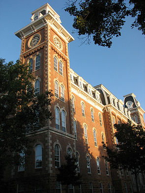 The University of Arkansas at Fayetteville was founded in 1871 on the site of a hilltop farm that overlooked the Ozark Mountains, giving it the nickname "The Hill".
The University of Arkansas
is located in Fayetteville, in Washington County. Historically, Cane Hill College
in Canehill
was the first college in Arkansas, prior to the University of Arkansas' founding in 1871. Canehill likely brought the University of Arkansas to Washington County when the state was trying to decide on the location of the state's university, the history of education in Washington County likely was a factor in the decision.
County (United States)
In the United States, a county is a geographic subdivision of a state , usually assigned some governmental authority. The term "county" is used in 48 of the 50 states; Louisiana is divided into parishes and Alaska into boroughs. Parishes and boroughs are called "county-equivalents" by the U.S...
located in the northwest part of the U.S. state
U.S. state
A U.S. state is any one of the 50 federated states of the United States of America that share sovereignty with the federal government. Because of this shared sovereignty, an American is a citizen both of the federal entity and of his or her state of domicile. Four states use the official title of...
of Arkansas
Arkansas
Arkansas is a state located in the southern region of the United States. Its name is an Algonquian name of the Quapaw Indians. Arkansas shares borders with six states , and its eastern border is largely defined by the Mississippi River...
. As of 2010, the population was 203,065. The county seat
County seat
A county seat is an administrative center, or seat of government, for a county or civil parish. The term is primarily used in the United States....
is Fayetteville
Fayetteville, Arkansas
Fayetteville is the county seat of Washington County, and the third largest city in Arkansas. The city is centrally located within the county and is home to the University of Arkansas. Fayetteville is also deep in the Boston Mountains, a subset of The Ozarks...
. Washington County is Arkansas's 17th county, formed on October 17, 1828, and named for George Washington
George Washington
George Washington was the dominant military and political leader of the new United States of America from 1775 to 1799. He led the American victory over Great Britain in the American Revolutionary War as commander-in-chief of the Continental Army from 1775 to 1783, and presided over the writing of...
, the first President of the United States
President of the United States
The President of the United States of America is the head of state and head of government of the United States. The president leads the executive branch of the federal government and is the commander-in-chief of the United States Armed Forces....
. Washington County is part of the Fayetteville-Springdale-Rogers, AR-MO Metropolitan Statistical Area
Fayetteville-Springdale-Rogers Metropolitan Area
The Fayetteville-Springdale-Rogers Metropolitan Statistical Area as defined by the United States Census Bureau is a four-county area including three Arkansas counties and one Missouri county...
.
History
Beginning as Cherokee Territory with the Treaty of 1817, Washington County has a long history. The area became known as Lovely County and a year later, Washington County was cut from Lovey County following another Cherokee Treaty. The court houseWashington County Courthouse (Arkansas)
The Washington County Courthouse is a courthouse in Fayetteville, Arkansas, United States, the county seat of Washington County, built in 1905. It was listed on the National Register of Historic Places in 1972. The courthouse is the fifth building to serve Washington County, with the prior...
was centrally located in the city of Washington, modern-day Fayetteville
Fayetteville, Arkansas
Fayetteville is the county seat of Washington County, and the third largest city in Arkansas. The city is centrally located within the county and is home to the University of Arkansas. Fayetteville is also deep in the Boston Mountains, a subset of The Ozarks...
(renamed to avoid confusion with Washington, Arkansas
Washington, Arkansas
Washington is a city in Hempstead County, Arkansas, United States. The population was 148 at the 2000 census. It is part of the Hope Micropolitan Statistical Area.The city is also home to Old Washington Historic State Park....
in South Arkansas
South Arkansas
South Arkansas lies within the southern most portions of Arkansas Gulf Coastal Plain and Delta regions. It encompasses the lower 15 counties of the state.-History:...
). The Lee Creek Valley in south Washington county contained many of the county's early settlements, including Cane Hill
Canehill, Arkansas
Canehill is an unincorporated community in Cane Hill Township, Washington County, Arkansas, United States. Canehill is on Arkansas Highway 45 about southwest of Fayetteville and east of the Oklahoma border....
and Evansville
Evansville, Arkansas
Evansville, Arkansas is an unincorporated community in Vineyard Township, Washington County, Arkansas, United States. It is located on Arkansas Highway 59 near the Oklahoma state line....
.
Arkansas College and Cane Hill College
Cane Hill College
Cane Hill College, originally Cane Hill School, was the first institution of higher learning in Arkansas. It operated in Canehill, Arkansas from 1834 until 1891.-Cane Hill School :...
were both founded in Washington County within a day of each other in 1834, with the University of Arkansas
University of Arkansas
The University of Arkansas is a public, co-educational, land-grant, space-grant, research university. It is classified by the Carnegie Foundation as a research university with very high research activity. It is the flagship campus of the University of Arkansas System and is located in...
being founded in Fayetteville in 1834. The county witnessed many Civil War
Civil war
A civil war is a war between organized groups within the same nation state or republic, or, less commonly, between two countries created from a formerly-united nation state....
battles, including the Battle of Fayetteville
Action at Fayetteville
The Battle of Fayetteville was a skirmish of the American Civil War fought on 18 April 1863 and had an undecided result.-The battle:Confederate Brigadier General William L. Cabell departed Ozark, Arkansas with 900 cavalry with the intent to dislodge the Union from Fayetteville, Arkansas...
, the Battle of Prairie Grove
Battle of Prairie Grove
The Battle of Prairie Grove was a battle of the American Civil War fought on 7 December 1862, that resulted in a tactical stalemate but essentially secured northwest Arkansas for the Union.-Strategic situation: Union:...
, and the Battle of Cane Hill
Battle of Cane Hill
The Battle of Cane Hill was fought during the American Civil War on November 28, 1862 in Washington County, Arkansas. Union troops under Brig. Gen. James G. Blunt drove Confederates under Brig. Gen. John S...
. Many area residents had northern sympathies, slavery was not prominent, plantations were rare and the source of information at the time was from White River
White River (Arkansas)
The White River is a 722-mile long river that flows through the U.S. states of Arkansas and Missouri.-Course:The source of the White River is in the Boston Mountains of northwest Arkansas, in the Ozark-St. Francis National Forest southeast of Fayetteville...
travelers, not the more-southern Arkansas River
Arkansas River
The Arkansas River is a major tributary of the Mississippi River. The Arkansas generally flows to the east and southeast as it traverses the U.S. states of Colorado, Kansas, Oklahoma, and Arkansas. The river's initial basin starts in the Western United States in Colorado, specifically the Arkansas...
. The Butterfield Overland Mail
Butterfield Overland Mail
The Butterfield Overland Mail Trail was a stagecoach route in the United States, operating from 1857 to 1861. It was a conduit for the U.S. mail from two eastern termini, Memphis, Tennessee and St. Louis, Missouri, meeting Fort Smith, Arkansas, and continuing through Indian Territory, New Mexico,...
route was established through the area in 1858, bringing many westbound families to settle in Washington County.
The economy of Washington County was based upon apples in the late 19th century. A good mixture of wet weather, altitude, and loamy soils formed a great environment for apple orchards. First forming in areas around Lincoln
Lincoln, Arkansas
Lincoln is a city in Washington County, Arkansas, United States. The population was 1,752 at the 2000 census. It is part of the Fayetteville–Springdale–Rogers, AR-MO Metropolitan Statistical Area.-Geography:...
, Evansville
Evansville, Arkansas
Evansville, Arkansas is an unincorporated community in Vineyard Township, Washington County, Arkansas, United States. It is located on Arkansas Highway 59 near the Oklahoma state line....
, and Cane Hill
Canehill, Arkansas
Canehill is an unincorporated community in Cane Hill Township, Washington County, Arkansas, United States. Canehill is on Arkansas Highway 45 about southwest of Fayetteville and east of the Oklahoma border....
in the 1830s, apple orchards began to form all across the county. The United States Census
United States Census
The United States Census is a decennial census mandated by the United States Constitution. The population is enumerated every 10 years and the results are used to allocate Congressional seats , electoral votes, and government program funding. The United States Census Bureau The United States Census...
reported a crop of 614,924 bushels of apples produced by the county in 1900, the highest in the state. Several varieties of apple were discovered in the area including Shannon Pippin, Wilson June, and most notably the Arkansas Black. The Ben Davis
Ben Davis (apple)
- Overview :During the 19th century it was a popular commercial apple due to the ruggedness and keeping qualities of the fruit, but as packing and transportation techniques improved the variety fell out of favour, replaced by varieties considered to have better flavour...
became the apple of choice in the area for sale and shipment across the region. Corn became the dominant crop, outselling apples by almost $500,000 in 1900.
Arkansas Industrial University
University of Arkansas
The University of Arkansas is a public, co-educational, land-grant, space-grant, research university. It is classified by the Carnegie Foundation as a research university with very high research activity. It is the flagship campus of the University of Arkansas System and is located in...
was founded in the growing community of Fayetteville in 1871 upon a donation of farmland from William McIlroy. The school was founded as the flagship institution of higher learning in the state, changing its name in 1899 to the University of Arkansas. Railroads came to Washington County after the St. Louis – San Francisco Railway (Frisco) decided to build a line to Texas
Texas
Texas is the second largest U.S. state by both area and population, and the largest state by area in the contiguous United States.The name, based on the Caddo word "Tejas" meaning "friends" or "allies", was applied by the Spanish to the Caddo themselves and to the region of their settlement in...
through Fort Smith
Fort Smith, Arkansas
Fort Smith is the second-largest city in Arkansas and one of the two county seats of Sebastian County. With a population of 86,209 in 2010, it is the principal city of the Fort Smith, Arkansas-Oklahoma Metropolitan Statistical Area, a region of 298,592 residents which encompasses the Arkansas...
. Two lines were proposed, one through Prairie Grove
Prairie Grove, Arkansas
Prairie Grove is a city in Washington County, Arkansas, United States. The population was 2,540 at the 2000 census. It is part of the Fayetteville–Springdale–Rogers, AR-MO Metropolitan Statistical Area. Located here is the Prairie Grove Battlefield State Park...
and one through Fayetteville. Upon hearing the news, many Fayetteville residents and area farmers sold or donated the right of way to the Frisco to entice them into the Fayetteville path. The residents' efforts paid off and in 1881 the first passenger train arrived in Fayetteville. The county would continue to grow with the establishment of more churches and schools as a fesult of the railroad's completion. Rural parts of the county began to lose population in the 1920s with the Great Depression
Great Depression
The Great Depression was a severe worldwide economic depression in the decade preceding World War II. The timing of the Great Depression varied across nations, but in most countries it started in about 1929 and lasted until the late 1930s or early 1940s...
and high taxes forcing residents either to cities like Fayetteville or west to Oklahoma
Oklahoma
Oklahoma is a state located in the South Central region of the United States of America. With an estimated 3,751,351 residents as of the 2010 census and a land area of 68,667 square miles , Oklahoma is the 28th most populous and 20th-largest state...
. The less-populated areas became the Ozark National Forest and Devil's Den State Park
Devil's Den State Park
Devil's Den State Park is a Arkansas state park in Washington County, near West Fork, Arkansas in the United States. The park was built by the Civilian Conservation Corps beginning in 1933. Devil's Den State Park is in the Lee Creek Valley in the Boston Mountains which are the southwestern part of...
.
Geography
According to the 2000 census, the county has a total area of 956.01 square miles (2,476.1 km²), of which 949.72 square miles (2,459.8 km²) (or 99.34%) is land and 6.29 square miles (16.3 km²) (or 0.66%) is water. The county is in the Boston MountainsBoston Mountains
The Boston Mountains area is a high and deeply dissected plateau located in northern Arkansas and eastern Oklahoma. The Oklahoma portion of the range is locally referred to as the Cookson Hills. The rocks of the region are essentially little disturbed, flat-lying sedimentary layers of the Paleozoic...
, a subdivision of the Ozark Mountains. Devil's Den State Park
Devil's Den State Park
Devil's Den State Park is a Arkansas state park in Washington County, near West Fork, Arkansas in the United States. The park was built by the Civilian Conservation Corps beginning in 1933. Devil's Den State Park is in the Lee Creek Valley in the Boston Mountains which are the southwestern part of...
in southern Washington County is known for its picturesque views and mountain vistas. Washington County also contains Lake Wedington, located in scenic country west of Farmington
Farmington, Arkansas
Farmington is a city in Washington County, Arkansas, United States. The population was 3,605 at the 2000 census. It is part of the Fayetteville–Springdale–Rogers, AR-MO Metropolitan Statistical Area....
on Wedington Drive.
Geology
Washington County sits on a basementBasement
__FORCETOC__A basement is one or more floors of a building that are either completely or partially below the ground floor. Basements are typically used as a utility space for a building where such items as the furnace, water heater, breaker panel or fuse box, car park, and air-conditioning system...
of Precambrian
Precambrian
The Precambrian is the name which describes the large span of time in Earth's history before the current Phanerozoic Eon, and is a Supereon divided into several eons of the geologic time scale...
granite
Granite
Granite is a common and widely occurring type of intrusive, felsic, igneous rock. Granite usually has a medium- to coarse-grained texture. Occasionally some individual crystals are larger than the groundmass, in which case the texture is known as porphyritic. A granitic rock with a porphyritic...
and rhyolite
Rhyolite
This page is about a volcanic rock. For the ghost town see Rhyolite, Nevada, and for the satellite system, see Rhyolite/Aquacade.Rhyolite is an igneous, volcanic rock, of felsic composition . It may have any texture from glassy to aphanitic to porphyritic...
, as most of the continental interior of the United States
United States
The United States of America is a federal constitutional republic comprising fifty states and a federal district...
does. Much of the county's geologic history must be inferred from nearby Oklahoma
Oklahoma
Oklahoma is a state located in the South Central region of the United States of America. With an estimated 3,751,351 residents as of the 2010 census and a land area of 68,667 square miles , Oklahoma is the 28th most populous and 20th-largest state...
and Missouri
Missouri
Missouri is a US state located in the Midwestern United States, bordered by Iowa, Illinois, Kentucky, Tennessee, Arkansas, Oklahoma, Kansas and Nebraska. With a 2010 population of 5,988,927, Missouri is the 18th most populous state in the nation and the fifth most populous in the Midwest. It...
research, due to the steepness of the more recently-formed mountains that did not form in the neighboring states. This igneous material was eroded until the Paleozoic
Paleozoic
The Paleozoic era is the earliest of three geologic eras of the Phanerozoic eon, spanning from roughly...
, when oceans covered the now-low lying area. These oceans came and retreated for 300 million years, depositing various different sedements during that time. This created fossiliferous limestone
Fossiliferous limestone
Fossiliferous limestone may refer to the following limestones containing fossils:-Rock types:*Carboniferous limestone*Coquina*Coral rag*Coral sand*Diatomaceous earth*Fossil beach*Lagerstätte*Lithographic Limestone*Keystone*Marl*Millstone...
and ripple marked
Ripple marks
In geology, ripple marks are sedimentary structures and indicate agitation by water or wind.- Defining ripple cross-laminae and asymmetric ripples :...
-sandstone, both present throughout the north part of the county as evidence of ancient oceans.
After the oceans receded, sediments were deposited from the Devonian
Devonian
The Devonian is a geologic period and system of the Paleozoic Era spanning from the end of the Silurian Period, about 416.0 ± 2.8 Mya , to the beginning of the Carboniferous Period, about 359.2 ± 2.5 Mya...
, Mississippian, and Pennsylvanian
Pennsylvanian
The Pennsylvanian is, in the ICS geologic timescale, the younger of two subperiods of the Carboniferous Period. It lasted from roughly . As with most other geochronologic units, the rock beds that define the Pennsylvanian are well identified, but the exact date of the start and end are uncertain...
periods. These are the rocks that are visible today. During this deposition period, the county had a climate similar to that of the present-day Bahamas
The Bahamas
The Bahamas , officially the Commonwealth of the Bahamas, is a nation consisting of 29 islands, 661 cays, and 2,387 islets . It is located in the Atlantic Ocean north of Cuba and Hispaniola , northwest of the Turks and Caicos Islands, and southeast of the United States...
, as the equator
Equator
An equator is the intersection of a sphere's surface with the plane perpendicular to the sphere's axis of rotation and containing the sphere's center of mass....
was north of Washington County. The Devonian brought mostly shale
Shale
Shale is a fine-grained, clastic sedimentary rock composed of mud that is a mix of flakes of clay minerals and tiny fragments of other minerals, especially quartz and calcite. The ratio of clay to other minerals is variable. Shale is characterized by breaks along thin laminae or parallel layering...
s, the Mississipian brought the limestone
Limestone
Limestone is a sedimentary rock composed largely of the minerals calcite and aragonite, which are different crystal forms of calcium carbonate . Many limestones are composed from skeletal fragments of marine organisms such as coral or foraminifera....
s and chert visible in the bluffs. This chert is present throughout most of the county in sediment form. The county is also home to the Boone formation (red soils), white limestones, the Wedington Sandstone, the Bastesville
Batesville, Arkansas
Batesville is the county seat and largest city of Independence County, Arkansas, United States, 80 miles northeast of Little Rock, the state capital. According to 2005 Census Bureau estimates, the population of the city was 9,556...
Sandstone, the Pitkin
Pitkin Corner, Arkansas
Pitkin Corner is an unincorporated community in West Fork Township, Washington County, Arkansas, United States. It is located on Washington County Road 35 west of the Woolsey Bridge....
formation (ocean-fossil limestone), and the Fayetteville Shale
Fayetteville Shale
The Fayetteville Shale is a geologic formation of Mississippian age composed of tight shale in Arkansas. It is named for Fayetteville, Arkansas and requires hydraulic fracturing to release the natural gas contained within....
.
Settlers were attracted to the area by its numerous streams, used to power gristmill
Gristmill
The terms gristmill or grist mill can refer either to a building in which grain is ground into flour, or to the grinding mechanism itself.- Early history :...
s, sandstone
Sandstone
Sandstone is a sedimentary rock composed mainly of sand-sized minerals or rock grains.Most sandstone is composed of quartz and/or feldspar because these are the most common minerals in the Earth's crust. Like sand, sandstone may be any colour, but the most common colours are tan, brown, yellow,...
s and clay
Clay
Clay is a general term including many combinations of one or more clay minerals with traces of metal oxides and organic matter. Geologic clay deposits are mostly composed of phyllosilicate minerals containing variable amounts of water trapped in the mineral structure.- Formation :Clay minerals...
s for use in construction, lime
Agricultural lime
Agricultural lime, also called aglime, agricultural limestone, garden lime or liming, is a soil additive made from pulverized limestone or chalk. The primary active component is calcium carbonate...
-sweetened soil, and chert
Chert
Chert is a fine-grained silica-rich microcrystalline, cryptocrystalline or microfibrous sedimentary rock that may contain small fossils. It varies greatly in color , but most often manifests as gray, brown, grayish brown and light green to rusty red; its color is an expression of trace elements...
for road construction.
Today, Washington County consists of two main formations, the Boston Mountains
Boston Mountains
The Boston Mountains area is a high and deeply dissected plateau located in northern Arkansas and eastern Oklahoma. The Oklahoma portion of the range is locally referred to as the Cookson Hills. The rocks of the region are essentially little disturbed, flat-lying sedimentary layers of the Paleozoic...
and the Springfield Plateau. During the late Triassic
Triassic
The Triassic is a geologic period and system that extends from about 250 to 200 Mya . As the first period of the Mesozoic Era, the Triassic follows the Permian and is followed by the Jurassic. Both the start and end of the Triassic are marked by major extinction events...
, sediment
Sediment
Sediment is naturally occurring material that is broken down by processes of weathering and erosion, and is subsequently transported by the action of fluids such as wind, water, or ice, and/or by the force of gravity acting on the particle itself....
s were deposited on top of the Springfield Plateau, forming the Boston Mountains. Erosion of these sediments causes the Boston Mountains to be carved steeply in the south, while in the north of the county, the Boston Mountain sediments are almost entirely eroded, exposing the older Springfield formation.
Major highways
Washington County has contained the Ozark TrailOzark Trail (auto trail)
The Ozark Trail was a network of locally maintained roads and highways organized by the Ozark Trails Association that predated the United States federal highway system. The roads ran from St. Louis, Missouri, to El Paso, Texas, and Santa Fe, New Mexico, over a series of routes. These roads were...
, Trail of Tears
Trail of Tears
The Trail of Tears is a name given to the forced relocation and movement of Native American nations from southeastern parts of the United States following the Indian Removal Act of 1830...
, and the Butterfield Overland Mail
Butterfield Overland Mail
The Butterfield Overland Mail Trail was a stagecoach route in the United States, operating from 1857 to 1861. It was a conduit for the U.S. mail from two eastern termini, Memphis, Tennessee and St. Louis, Missouri, meeting Fort Smith, Arkansas, and continuing through Indian Territory, New Mexico,...
route. Today, Interstate 540
Interstate 540 (Arkansas)
Interstate 540 in Arkansas is a spur of Interstate 40 between Fort Smith and Northwest Arkansas; the Northwest Arkansas segment is proposed to become part of an expanded Interstate 49. I-540 provides an Interstate Highway path between Fayetteville and Little Rock via Interstate 40. This links the...
serves as the county's main thoroughfare, and connects the University of Arkansas with Fort Smith
Fort Smith, Arkansas
Fort Smith is the second-largest city in Arkansas and one of the two county seats of Sebastian County. With a population of 86,209 in 2010, it is the principal city of the Fort Smith, Arkansas-Oklahoma Metropolitan Statistical Area, a region of 298,592 residents which encompasses the Arkansas...
and Interstate 40
Interstate 40
Interstate 40 is the third-longest major east–west Interstate Highway in the United States, after I-90 and I-80. Its western end is at Interstate 15 in Barstow, California; its eastern end is at a concurrency of U.S. Route 117 and North Carolina Highway 132 in Wilmington, North Carolina...
. Plans call for Interstate 49 to be extended along current Interstate 540 through Washington County to ultimately connect New Orleans, Louisiana
New Orleans, Louisiana
New Orleans is a major United States port and the largest city and metropolitan area in the state of Louisiana. The New Orleans metropolitan area has a population of 1,235,650 as of 2009, the 46th largest in the USA. The New Orleans – Metairie – Bogalusa combined statistical area has a population...
with Kansas City, Missouri
Kansas City, Missouri
Kansas City, Missouri is the largest city in the U.S. state of Missouri and is the anchor city of the Kansas City Metropolitan Area, the second largest metropolitan area in Missouri. It encompasses in parts of Jackson, Clay, Cass, and Platte counties...
.
|
 US Route 71 Business US Route 71 Business Highway 16 Highway 16 Highway 45 Highway 45Arkansas Highway 45 Arkansas Highway 45 is a designation for two state highways in northwest Arkansas. The southern segment of runs north in Sebastian County from AR 96 into Fort Smith. A northern segment of runs from Dutch Mills through Fayetteville to Clifty...  Highway 59 Highway 59 |
 Highway 74 Highway 74Arkansas Highway 74 Arkansas Highway 74 is a series of state highways of total in Northwest and north central Arkansas and comprises eight separate sections....  Highway 112 Highway 112 Highway 156 Highway 156 Highway 170 Highway 170 |
 Highway 180 Highway 180 Highway 220 Highway 220 Highway 244 Highway 244 Highway 265 Highway 265 |
 Highway 303 Highway 303Arkansas Highway 303 -Northern route:Arkansas Highway 303 is a state highway of in Washington and Benton Counties.-Route description:AR 303 begins at AR 45 near Mayfield and runs north to meet US 412 west of Spring Valley... |
 U.S. Route 412
Adjacent counties
- Benton CountyBenton County, ArkansasBenton County is a county located in the U.S. state of Arkansas. As of the 2000 census, the population was 153,406. The U.S. Census Bureau 2010 population is 221,339. The county seat is Bentonville. Benton County was formed on 30 September 1836 and was named after Thomas Hart Benton, a U.S...
(north) - Madison CountyMadison County, ArkansasMadison County is a county located in the U.S. state of Arkansas. As of 2010, the population was 15,717. The county seat is Huntsville. The county was formed on September 30, 1836, and named for James Madison, President of the United States...
(east) - Crawford County (south)
- Adair County, OklahomaAdair County, OklahomaAdair County is a county located in the U.S. state of Oklahoma. As of 2000, the population was 22,638. Its county seat is Stilwell. Adair County was named after the Adair family of the Cherokee tribe.-History:...
(west)
Demographics
As of the censusCensus
A census is the procedure of systematically acquiring and recording information about the members of a given population. It is a regularly occurring and official count of a particular population. The term is used mostly in connection with national population and housing censuses; other common...
of 2000, there were 157,715 people, 60,151 households, and 39,459 families residing in the county. The population density
Population density
Population density is a measurement of population per unit area or unit volume. It is frequently applied to living organisms, and particularly to humans...
was 166 people per square mile (64/km²). There were 64,330 housing units at an average density of 68 per square mile (26/km²). The racial makeup of the county was 88.00% White
Race (United States Census)
Race and ethnicity in the United States Census, as defined by the Federal Office of Management and Budget and the United States Census Bureau, are self-identification data items in which residents choose the race or races with which they most closely identify, and indicate whether or not they are...
, 2.24% Black
Race (United States Census)
Race and ethnicity in the United States Census, as defined by the Federal Office of Management and Budget and the United States Census Bureau, are self-identification data items in which residents choose the race or races with which they most closely identify, and indicate whether or not they are...
or African American
Race (United States Census)
Race and ethnicity in the United States Census, as defined by the Federal Office of Management and Budget and the United States Census Bureau, are self-identification data items in which residents choose the race or races with which they most closely identify, and indicate whether or not they are...
, 1.25% Native American
Race (United States Census)
Race and ethnicity in the United States Census, as defined by the Federal Office of Management and Budget and the United States Census Bureau, are self-identification data items in which residents choose the race or races with which they most closely identify, and indicate whether or not they are...
, 1.54% Asian
Race (United States Census)
Race and ethnicity in the United States Census, as defined by the Federal Office of Management and Budget and the United States Census Bureau, are self-identification data items in which residents choose the race or races with which they most closely identify, and indicate whether or not they are...
, 0.53% Pacific Islander
Race (United States Census)
Race and ethnicity in the United States Census, as defined by the Federal Office of Management and Budget and the United States Census Bureau, are self-identification data items in which residents choose the race or races with which they most closely identify, and indicate whether or not they are...
, 4.26% from other races
Race (United States Census)
Race and ethnicity in the United States Census, as defined by the Federal Office of Management and Budget and the United States Census Bureau, are self-identification data items in which residents choose the race or races with which they most closely identify, and indicate whether or not they are...
, and 2.17% from two or more races. 8.20% of the population were Hispanic
Race (United States Census)
Race and ethnicity in the United States Census, as defined by the Federal Office of Management and Budget and the United States Census Bureau, are self-identification data items in which residents choose the race or races with which they most closely identify, and indicate whether or not they are...
or Latino
Race (United States Census)
Race and ethnicity in the United States Census, as defined by the Federal Office of Management and Budget and the United States Census Bureau, are self-identification data items in which residents choose the race or races with which they most closely identify, and indicate whether or not they are...
of any race.
There were 60,151 households out of which 32.50% had children under the age of 18 living with them, 52.30% were married couples
Marriage
Marriage is a social union or legal contract between people that creates kinship. It is an institution in which interpersonal relationships, usually intimate and sexual, are acknowledged in a variety of ways, depending on the culture or subculture in which it is found...
living together, 9.40% had a female householder with no husband present, and 34.40% were non-families. 25.80% of all households were made up of individuals and 7.10% had someone living alone who was 65 years of age or older. The average household size was 2.52 and the average family size was 3.07.
In the county the population was spread out with 25.00% under the age of 18, 15.30% from 18 to 24, 30.20% from 25 to 44, 19.50% from 45 to 64, and 9.90% who were 65 years of age or older. The median age was 31 years. For every 100 females there were 100.40 males. For every 100 females age 18 and over, there were 98.70 males.
The median income for a household in the county was $34,691, and the median income for a family was $42,795. Males had a median income of $29,428 versus $21,769 for females. The per capita income
Per capita income
Per capita income or income per person is a measure of mean income within an economic aggregate, such as a country or city. It is calculated by taking a measure of all sources of income in the aggregate and dividing it by the total population...
for the county was $17,347. About 9.40% of families and 14.60% of the population were below the poverty line, including 16.50% of those under age 18 and 10.20% of those age 65 or over.
As of the 2010 Census Washington County had a population of 203,065. The racial makeup of the county was 74.14% Non-Hispanic white, 2.96% black, 1.18% Native American, 2.17% Asian, 2.03% Pacific Islander, 0.11% non-Hispanics of some other race, 2.16% Non-Hispanics of two or more races and 15.49% Hispanic.
Unified school districts
There are 8 school districts in the county.- Elkins School District
- Farmington School District
- Fayetteville School DistrictFayetteville Public SchoolsThe Fayetteville Public Schools is the oldest public school district in Arkansas. The system was established with the creation of public schools in Arkansas in 1871, the same year as the University of Arkansas, also located in Fayetteville, Arkansas...
- Greenland School District
- Lincoln School District
- Prairie Grove School District
- Springdale School District
- West Fork School District
Colleges and universities
The University of Arkansas
University of Arkansas
The University of Arkansas is a public, co-educational, land-grant, space-grant, research university. It is classified by the Carnegie Foundation as a research university with very high research activity. It is the flagship campus of the University of Arkansas System and is located in...
is located in Fayetteville, in Washington County. Historically, Cane Hill College
Cane Hill College
Cane Hill College, originally Cane Hill School, was the first institution of higher learning in Arkansas. It operated in Canehill, Arkansas from 1834 until 1891.-Cane Hill School :...
in Canehill
Canehill, Arkansas
Canehill is an unincorporated community in Cane Hill Township, Washington County, Arkansas, United States. Canehill is on Arkansas Highway 45 about southwest of Fayetteville and east of the Oklahoma border....
was the first college in Arkansas, prior to the University of Arkansas' founding in 1871. Canehill likely brought the University of Arkansas to Washington County when the state was trying to decide on the location of the state's university, the history of education in Washington County likely was a factor in the decision.
Cities and towns
|
Goshen, Arkansas Goshen is a town in Washington County, Arkansas, United States. The population was 752 at the 2000 census. It is part of the Fayetteville–Springdale–Rogers, AR-MO Metropolitan Statistical Area.-Geography:... Greenland, Arkansas Greenland is a city in Washington County, Arkansas, United States. The population was 907 at the 2000 census. It is part of the Fayetteville–Springdale–Rogers, AR-MO Metropolitan Statistical Area.-Geography:... Johnson, Arkansas Johnson is a city in Washington County, Arkansas, United States. The city was incorporated in 1961. The population was 3,354 at the 2010 census... |
Lincoln, Arkansas Lincoln is a city in Washington County, Arkansas, United States. The population was 1,752 at the 2000 census. It is part of the Fayetteville–Springdale–Rogers, AR-MO Metropolitan Statistical Area.-Geography:... Prairie Grove, Arkansas Prairie Grove is a city in Washington County, Arkansas, United States. The population was 2,540 at the 2000 census. It is part of the Fayetteville–Springdale–Rogers, AR-MO Metropolitan Statistical Area. Located here is the Prairie Grove Battlefield State Park... Springdale, Arkansas As of the census of 2010, there were 69,797 people, 22,805 households, and 16,640 families residing in the city. The racial makeup of the city was 64.7% White, 0.82% Black or African American, 1.8% Native American, 1.4% Asian, 5.7% Pacific Islander, 22% from other races, and 2.9% from two or more... |
Tontitown, Arkansas Tontitown is a city in Washington County, Arkansas, United States. The population was 2,460 at the 2010 census. Tontitown is part of the Fayetteville–Springdale–Rogers, AR-MO Metropolitan Statistical Area.... West Fork, Arkansas West Fork is a city in Washington County, Arkansas, United States. The population is 2,317 at the 2010 census. It is part of the Fayetteville–Springdale–Rogers, AR-MO Metropolitan Statistical Area.-Geography:... Winslow, Arkansas Winslow is a city in Washington County, Arkansas, United States. The population was 399 at the 2000 census. It is part of the Fayetteville-Springdale-Rogers Metropolitan Area.-History:... |
Communities
|
Townships
Townships in Arkansas are the divisions of a county. Each township includes unincorporated areas and some may have incorporated towns or cities within part of their space. Townships have limited purposes in modern times. However, they are of value for historical purposes in terms of genealogical research. Each town or city is within one or more townships in an Arkansas county based on census maps. The townships of Washington County are listed below. In Washington County, each incorporated town/city is at least partially located within its namesake township.
|
Farmington Township, Washington County, Arkansas The Township of Farmington is one of thirty-seven townships in Washington County, Arkansas, USA. As of the 2000 census, its total population was 3605.-Geography:According to the United States Census Bureau, Farmington Township covers an area of ; all land.... Fayetteville Township, Washington County, Arkansas Fayetteville Township is one of thirty-seven townships in Washington County, Arkansas, USA. As of the 2000 census, its total population was 58,047. The township contains the City of Fayetteville in its entirety.-Geography:... Goshen Township, Washington County, Arkansas Goshen Township is one of thirty-seven townships in Washington County, Arkansas, USA. As of the 2000 census, its total population was 1,656. The township contains the Town of Goshen and some surrounding unincorporated areas.-Geography:... Greenland Township, Washington County, Arkansas Greenland Township is one of thirty-seven townships in Washington County, Arkansas, USA. As of the 2000 census, its total population was 2,114.-Geography:... Harmon Township, Washington County, Arkansas Harmon Township is one of thirty-seven townships in Washington County, Arkansas, USA. As of the 2000 census, its total population was 1,394.-Geography:According to the United States Census Bureau, Harmon Township covers an area of , all land... Illinois Township, Washington County, Arkansas Illinois Township is one of thirty-seven townships in Washington County, Arkansas, USA. As of the 2000 census, its total population was 655.-Geography:According to the United States Census Bureau, Illinois Township covers an area of , all land.-Cemeteries:... Johnson Township, Washington County, Arkansas Johnson Township is one of thirty-seven townships in Washington County, Arkansas, USA. As of the 2000 census, its total population was 3,076.-Geography:According to the United States Census Bureau, Johnson Township covers an area of , all land.... Lee's Creek Township, Washington County, Arkansas Lee's Creek Township is one of thirty-seven townships in Washington County, Arkansas, USA. As of the 2000 census, its total population was 640.-Geography:... Lincoln Township, Washington County, Arkansas Lincoln Township is one of thirty-seven townships in Washington County, Arkansas, USA. As of the 2000 census, its total population was 1,752.-Geography:According to the United States Census Bureau, Lincoln Township covers an area of ; all land... Litteral Township, Washington County, Arkansas Litteral Township is one of thirty-seven townships in Washington County, Arkansas, USA. As of the 2000 census, its total population was 1,410.-Geography:According to the United States Census Bureau, Center Township covers an area of ; all land.... |
Marrs Hill Township, Washington County, Arkansas Marrs Hill Township is one of thirty-seven townships in Washington County, Arkansas, USA... Morrow Township, Washington County, Arkansas Morrow Township is one of thirty-seven townships in Washington County, Arkansas, USA. As of the 2000 census, its total population was 898.-Geography:According to the United States Census Bureau, Morrow Township covers an area of ; all land.-Cemeteries:... Prairie Township, Washington County, Arkansas Prairie Township is one of thirty-seven townships in Washington County, Arkansas, USA. As of the 2000 census, its total population was 3,526.-Geography:... Reed Township, Washington County, Arkansas Reed Township is one of thirty-seven townships in Washington County, Arkansas, USA. As of the 2000 census, its total population was 410.-Geography:According to the United States Census Bureau, Reed Township covers an area of , all land.... |
|
See also
- List of counties in Arkansas
- National Register of Historic Places listings in Washington County, ArkansasNational Register of Historic Places listings in Washington County, ArkansasThis is a list of the National Register of Historic Places listings in Washington County, Arkansas.This is intended to be a complete list of the properties and districts on the National Register of Historic Places in Washington County, Arkansas, United States...