

Washington, D.C. (northeast)
Encyclopedia
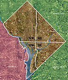
Quadrants of Washington, D.C.
Washington, D.C., is administratively divided into four geographical quadrants of unequal size, each delineated by their ordinal directions from the medallion located in the Crypt under the Rotunda of the Capitol...
, the capital of the United States
United States
The United States of America is a federal constitutional republic comprising fifty states and a federal district...
, and is located north of East Capitol Street
East Capitol Street
East Capitol Street is a major street that divides the northeast and southeast quadrants of Washington, D.C. It runs due east from the United States Capitol to the DC-Maryland border. The street is uninterrupted until Lincoln Park then continues eastward to Robert F. Kennedy Memorial Stadium...
and east of North Capitol Street
North Capitol Street
North Capitol Street is a street in Washington, D.C. that separates the Northwest and Northeast quadrants of the city. The street begins at D Street due north of the United States Capitol and continues northward 4½ miles to Nicholson Street where it is interrupted by Fort Slocum Park and the...
. Northeast neighborhoods include Brentwood
Brentwood, Washington, D.C.
Brentwood is a neighborhood in Northeast Washington, D.C. and is named after the Brentwood Mansion built at Florida Avenue and 6th Street NE in 1817 by Robert Brent, the first mayor of Washington City. He built it as a wedding present for his daughter Eleanor on her marriage as second wife to...
, Brookland
Brookland, Washington, D.C.
Brookland is a neighborhood in the Northeast quadrant of Washington, D.C., historically centered along 12th Street NE. Brookland is bounded by 9th Street NE to the west, Rhode Island Avenue NE to the south, and South Dakota Avenue to the east...
, Ivy City
Ivy City, Washington, D.C.
Ivy City is a small neighborhood in Northeast Washington. It is primarily an industrial neighborhood, dominated by warehouses and the Ivy City Yard, a railroad coach yard and maintenance facility for Amtrak. The area has undergone some revitalization with the influx of a few dance clubs and the...
, Marshall Heights, Pleasant Hill, Stanton Park, Trinidad
Trinidad, Washington, D.C.
Trinidad is a neighborhood located in Ward 5, in the northeast quadrant of Washington, D.C. and is a largely residential area.-Geography:Trinidad is bounded to the north by Mt. Olivet Road, to the west by West Virginia Avenue, to the south by Florida Avenue, and to the east by Bladensburg Road. To...
, Michigan Park, Riggs Park
Riggs Park
Riggs Park is a residential neighborhood in Northeast Washington, D.C. It is bounded by Riggs Road NE to the south and east, Eastern Avenue to the north, and Blair Road NE, Kansas Avenue NE, and North Capitol Street NE to the west....
, Fort Totten
Fort Totten, Washington, D.C.
Fort Totten is a park and neighborhood in northeast Washington, D.C.. The neighborhood is bordered by N Capitol St to the west, Riggs Rd NE to the north, the Red Line tracks to the east, and Hawaii Ave NE to the south. It is named after a Civil War-era fort. The Fort Totten Metro station is named...
, Fort Lincoln
Fort Lincoln, Washington, D.C.
Fort Lincoln is a neighborhood located in northeastern Washington, D.C. It is bounded by Bladensburg Road to the northwest, Eastern Avenue to the northeast, New York Avenue NE to the south, and South Dakota Avenue NE to the southwest...
, Edgewood
Edgewood, Washington, D.C.
Edgewood is a neighborhood in Northeast Washington, D.C Edgewood is bounded by Lincoln Road and Glenwood Cemetery to the west; the tracks for the Red Line of the Washington Metro to the east; Rhode Island Avenue NE to the south; and the combination of Irving Street, Michigan Avenue, and Monroe...
, Deanwood, Kenilworth
Kenilworth, Washington, D.C.
Kenilworth is a residential neighborhood in Northeast Washington, D.C., located on the eastern bank of the Anacostia River and just inside the D.C.-Maryland border. A large public housing complex, Kenilworth Courts, dominates the area...
, and Woodridge
Woodridge, Washington, D.C.
Woodridge, is a residential neighborhood located on the northeastern edge of Washington, D.C., bounded by Eastern Avenue on the east, Michigan Avenue to the north, South Dakota then 18th St. to the west, and Bladensburg Road to the south. Its central commercial strip is Rhode Island Avenue NE. It...
, as well as much of Capitol Hill
Capitol Hill, Washington, D.C.
Capitol Hill, aside from being a metonym for the United States Congress, is the largest historic residential neighborhood in Washington D.C., stretching easterly in front of the United States Capitol along wide avenues...
. The population of Northeast is predominantly African-American, particularly east of the Anacostia River
Anacostia River
The Anacostia River is a river in the Mid Atlantic region of the United States. It flows from Prince George's County in Maryland into Washington, D.C., where it joins with the Washington Channel to empty into the Potomac River at Buzzard Point. It is approximately long...
.
It is also home to a large number of small Catholic
Roman Catholic Church
The Catholic Church, also known as the Roman Catholic Church, is the world's largest Christian church, with over a billion members. Led by the Pope, it defines its mission as spreading the gospel of Jesus Christ, administering the sacraments and exercising charity...
institutions, mostly in the Brookland neighborhood, including The Catholic University of America
The Catholic University of America
The Catholic University of America is a private university located in Washington, D.C. in the United States. It is a pontifical university of the Catholic Church in the United States and the only institution of higher education founded by the U.S. Catholic bishops...
, St. Anselm's Abbey School
St. Anselm's Abbey School
St. Anselm's Abbey School is an all boys's preparatory school for grades six through twelve in Washington D.C.. It is located in the Roman Catholic Archdiocese of Washington...
, Trinity University, the Franciscan Monastery, Whitefriars Hall, the Basilica of the National Shrine of the Immaculate Conception
Basilica of the National Shrine of the Immaculate Conception
The Basilica of the National Shrine of the Immaculate Conception is a prominent Latin Rite Catholic basilica located in Washington, D.C., honoring the Blessed Virgin Mary as Our Lady of the Immaculate Conception, the Patroness of the United States...
, the Pope John Paul II Cultural Center
Pope John Paul II Cultural Center
The Pope John Paul II Cultural Center was established to house a Roman Catholic museum and think tank in Washington, D.C. The concept for the center began at a meeting between Pope John Paul II and then-Bishop Adam Maida in 1988. The building is set on 12 acres adjacent to The Catholic University...
, and the headquarters of the United States Conference of Catholic Bishops
United States Conference of Catholic Bishops
The United States Conference of Catholic Bishops is the episcopal conference of the Catholic Church in the United States. Founded in 1966 as the joint National Conference of Catholic Bishops and United States Catholic Conference, it is composed of all active and retired members of the Catholic...
.
Two large public gardens are located below the waistline of the Anacostia River
Anacostia River
The Anacostia River is a river in the Mid Atlantic region of the United States. It flows from Prince George's County in Maryland into Washington, D.C., where it joins with the Washington Channel to empty into the Potomac River at Buzzard Point. It is approximately long...
in Northeast: the United States National Arboretum
United States National Arboretum
The United States National Arboretum is an arboretum in Washington, D.C., operated by the United States Department of Agriculture's Agricultural Research Service as a division of the Henry A. Wallace Beltsville Agricultural Research Center...
and Kenilworth Aquatic Gardens. Other important sites in the quadrant include the ruins of several Civil War
American Civil War
The American Civil War was a civil war fought in the United States of America. In response to the election of Abraham Lincoln as President of the United States, 11 southern slave states declared their secession from the United States and formed the Confederate States of America ; the other 25...
-era forts and Gallaudet University
Gallaudet University
Gallaudet University is a federally-chartered university for the education of the deaf and hard of hearing, located in the District of Columbia, U.S...
.
Politically, Northeast includes most of Ward 5, much of Wards 6 and 7, and parts of Ward 4.
It is accessible via the Orange
Orange Line (Washington Metro)
The Orange Line of the Washington Metro consists of 26 rapid transit stations from Vienna to New Carrollton. It has stations in Fairfax County and Arlington, Virginia, the District of Columbia, and Prince George's County, Maryland. Half of the line's stations are shared with the Blue Line, and over...
, Red
Red Line (Washington Metro)
The Red Line of the Washington Metro is a rail rapid transit service operating between 27 stations in Montgomery County, Maryland and the District of Columbia, United States. It is a primary line through downtown Washington, and the oldest and busiest line in the system...
, Blue
Blue Line (Washington Metro)
The Blue Line of the Washington Metro in the United States consists of 27 rapid transit stations from Franconia–Springfield to Largo Town Center. It has stations in Fairfax County, Alexandria and Arlington, Virginia, the District of Columbia, and Prince George's County, Maryland...
, Yellow
Yellow Line (Washington Metro)
The Yellow Line of the Washington Metro consists of 17 rapid transit stations from Huntington to Fort Totten. The line terminates at the Mount Vernon Square station during peak hours.Peak hours are 5 a.m. to 9:30 a.m. and 3 p.m. to 7 p.m. Service is extended to the Green Line stations during...
, and Green Lines
Green Line (Washington Metro)
The Green Line is one of five heavy rail subway lines that constitute the Washington Metro rapid transit system in the Washington, D.C., metropolitan area. The Green Line consists of 21 stations, with termini at Branch Avenue and at Greenbelt. The Green Line runs through Prince George's County,...
of the Washington Metro
Washington Metro
The Washington Metro, commonly called Metro, and unofficially Metrorail, is the rapid transit system in Washington, D.C., United States, and its surrounding suburbs. It is administered by the Washington Metropolitan Area Transit Authority , which also operates Metrobus service under the Metro name...
. Union Station is served by the MARC
MARC Train
MARC , known prior to 1984 as Maryland Rail Commuter Service, is a regional rail system comprising three lines in the Baltimore-Washington Metropolitan Area. MARC is administered by the Maryland Transit Administration , a Maryland Department of Transportation agency, and is operated under contract...
and Virginia Railway Express
Virginia Railway Express
The Virginia Railway Express is a regional/ commuter rail service that connects the Northern Virginia suburbs to Union Station in Washington, D.C., via two lines: the Fredericksburg Line from Fredericksburg, Virginia, and the Manassas Line from Broad Run/Airport station in Bristow,...
commuter rail systems, as well as by Amtrak
Amtrak
The National Railroad Passenger Corporation, doing business as Amtrak , is a government-owned corporation that was organized on May 1, 1971, to provide intercity passenger train service in the United States. "Amtrak" is a portmanteau of the words "America" and "track". It is headquartered at Union...
. The Greyhound Bus Terminal is located in this quadrant and is served by Greyhound
Greyhound Lines
Greyhound Lines, Inc., based in Dallas, Texas, is an intercity common carrier of passengers by bus serving over 3,700 destinations in the United States, Canada and Mexico, operating under the well-known logo of a leaping greyhound. It was founded in Hibbing, Minnesota, USA, in 1914 and...
, Peter Pan
Peter Pan Bus Lines
Peter Pan Bus Lines is a long-distance bus carrier headquartered in Springfield, Massachusetts. It operates in the northeastern United States. Over four million passengers per year travel on Peter Pan's bus routes....
, Trailways
Trailways Transportation System
The Trailways Transportation System is an American group of 80 independent bus companies that have entered into a franchising agreement. The company is headquartered in Fairfax, Virginia.- History :...
, and other bus
Bus
A bus is a road vehicle designed to carry passengers. Buses can have a capacity as high as 300 passengers. The most common type of bus is the single-decker bus, with larger loads carried by double-decker buses and articulated buses, and smaller loads carried by midibuses and minibuses; coaches are...
companies.