
Warringah Council
Encyclopedia
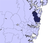
Warringah is a local council area
in the Northern Beaches
region of Sydney
, Australia
. Warringah Council overlaps with a number of suburbs from the Manly Council
area to the south and the Pittwater Council
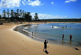
area to the north. It includes a number of popular beaches (which are also suburb names) for swimming and surfing such as Narrabeen
, Collaroy
and Dee Why
.
Warringah was ranked 41st out of 590 Local Government areas in Australia in the BankWest Quality of Life Index 2008.
) language group of the Garigal clan, who owned the land between Port Jackson
and Broken Bay
, extending to the Lane Cove River
in the west.
Warringah was explored early on in the settlement of Sydney
, only a few weeks after the arrival of the First Fleet
. However, it remained a rural area for most of the 1800s, with only small settlements in the valleys between headlands. While it was geographically close to the city centre, to reach the area over land from Sydney via Mona Vale Road was a trip of more than 100 kilometres.
in the north to Manly Lagoon to the south, and by Middle Harbour Creek
and Cowan Creek in the west. It covered 264 km2 and had a population of around 2800, with 700 dwellings. Under the then Shires Act, ratepayers with properties worth at least five pounds could vote for up to nine Councillors for a three-year term. The first Council was temporarily installed until official elections on 24 November 1906. The Council, originally titled as Aldermen
, first met in Narrabeen Progress Hall on 14 June 1906, and thereafter met in purpose-built chambers in Brookvale
. However these proved to be too small and the council moved meetings from 1912 for the next 60 years to a new Shire Hall also in Brookvale.
was established through the south-eastern area of the shire, running along Pittwater Road from Manly Lagoon
eventually stretching all the way to the tramshed at Narrabeen
in 1934, with an additional terminating line through Harbord to Freshwater Beach
. This, coupled with the opening of the Spit and Roseville bridges in 1924 led to increased interest and travel to the area, which increased even further with the opening of the Sydney Harbour Bridge
in 1932. Early subdivisions were usually given over for weekenders and holiday homes, and at the same time the surf clubs
and rock pools on the beaches began to be developed. After World War II
, urbanisation began to occur, with family homes beginning to be built in the area, especially near the beaches. Retail, light industry and improved public amenity soon followed. It was also around this time that the tram lines were progressively closed across Sydney, to give way to more lanes for motor vehicles.
The mid-1970s and late 1980s witnessed a rise in suburban expansion in the Northern Beaches area, prompting long term planning by Warringah Council, particularly during the term of Shire President Paul Couvret.
Work began on a new Dee Why
civic centre in 1971, designed by Sulman Prize
-winning architect Colin Madigan
, to replace the Shire Hall in Brookvale
which had been in use for the past 60 years. The building was completed in 1972 and the Council has remained there since 1973.
In November 1979, Warringah Council opened the Warringah Aquatic Centre at Frenchs Forest
. Prior to the opening of the Olympic Park at Homebush
, the Aquatic Centre hosted the NSW and Australian Swimming Titles, as well as the 1992 Olympic trials.
The Glen Street Theatre
was officially opened in July 1985 as part of the Forest Community Centre by the Shire President, Darren Jones.
The Minister for Local Government at the time, Gerry Peacocke, nevertheless announced the secession of A Riding from Warringah Council, considering that those who did not vote did not have any particular inclination to how they were governed, and thus Pittwater Council
was created.
On 2 May 1992, The Governor of New South Wales, Rear Admiral Peter Sinclair, proclaimed the establishment of the Municipality of Pittwater, the area of which roughly followed the area formerly known as ‘A’ Riding of the Warringah Shire.
Also on that day, the offices of Robert Dunn, Eric Green and Ronald Starr, former Warringah ‘A’ Riding Councillors, were terminated with those persons forming, with others, a Provisional Council of the Municipality of Pittwater.
 Soon after the secession of Pittwater, the Local Government Act 1993 was passed, causing Warringah to drop the term 'Shire' from its title, and the renaming of the Shire Clerk to General Manager and Shire President to Mayor. The remaining B, C and D Ridings were renamed the A, B and C Wards.
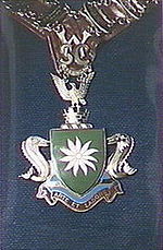
The Council's current logo, featuring a Flannel flower, was adopted in 1998. The Coat of Arms used for Warringah Council was adopted in 1968 and was retained for historical and traditional purposes and as such appears on the Mayoral chain and inside the Council chambers. It features Dolphin
supporters, a crested Wedge-tailed Eagle
, the Flannel flower within a shield, and the motto, "Arte et Labore" ("by Skill and Labour").
State Government and was triggered by the gaoling of two councillors for bribery. The Councillors involved, Dennis Thomas and George Knight, were prosecuted under the Secret Commissions Prohibition Act 1919 (NSW) for receiving bribes from a development company to influence planning and development decisions, and both received gaol sentences. C.J.Barnett, Department of Local Government, acted as Administrator April to May 1967. R.H.Cornish, Department of Local Government, acted as Administrator from November 1967 to December 1968.
State Government amid allegations of bribery, and local dissatisfaction with the handling of development applications at Palm Beach and Mona Vale amid alleged “discrepancies in council planning decisions”. Warringah was placed under administration for 16 months with Daniel Kelly from the Department of Local Government acting as Administrator from December 1985 until April 1986 and Richard Connolly, former Chairman of the Metropolitan Waste Disposal authority from June 1986 to March 1987.
Administrator Kelly advised that despite an "exhaustive examination" of the Mona Vale development by Council staff and its advisers that would normally lead to its approval, it would be in the best interests of the community and the developer "to have any doubts about the development to be settled once and for all". He subsequently sought legal advice from a leading authority on environmental law as to the merits of the application and the former Council's handling of it. Murray Tobias
QC
, subsequently advised that the Council had not exceeded its powers in its handling of the development. Tobias also advised that in respect to certain deficiencies that rendered the granting of the building approval invalid, that the deficiencies "were in all respects technical breaches of the Act committed without appreciation thereof by either Council, its Staff as well as the Developer and solely due to an oversight on the part of Council". He found that these resolutions were clearly valid...and that they therefore remedied the situation given by the Land and Environment Court of New South Wales
on 6 March 1986 and removed any point of continuing illegality."
The NSW Local Government Association, supported by more than 150 constituent NSW Councils, demanded that the State Government institute an Inquiry into the dismissal of Warringah Council. The NSW Ombudsman agreed to conduct his own Inquiry. Following the NSW Ombudsman's challenge against the government for its repeated refusal to provide him with all relevant files, it was subsequently found that there had been no evidence of corruption to support the dismissal, and that "the elected councillors were denied natural justice and were both unfairly and unlawfully dismissed". It was also revealed that the Cabinet, headed by Local Government Minister, Janice Crosio
, had made the decision to sack the council while ignoring the advice of the Under-secretary of the Department of Local Government who had been pushing for a public inquiry before the dimissal.
Investigations into bribery allegations against councillors by the NSW Fraud Squad and the Ombudsman did not result in any charges being laid against any councillor or member of staff. Warringah Council was returned after elections in early 1987 and resulted in 7 Councillors from the previous Council being returned to office, including the Shire President, Ted Jackson.
, announced a formal public inquiry into Warringah Council. Emeritus Professor Maurice Daly was appointed the commissioner by the Governor of New South Wales, Professor Marie Bashir
.
The commissioner found that the majority of the community had lost confidence in the councillors' ability to fulfill their roles and he recommended their dismissal. It was recommended that extra measures were to be taken to eliminate conflicts of interest in Council matters, as well as increasing ease of access to information held by council. The commissioner also recommended consideration of boundary changes or merger opportunities with the neighbouring councils of Manly
and Pittwater
.
The findings of the inquiry were criticised by the former Mayor, Julie Sutton, who said she found the report to be "very, very biased" and the then New South Wales Opposition Leader, John Brogden, who warned that the dismissal should not be used as a back door for amalgamations on the northern beaches or to prevent the elections scheduled for March 2004.
Following the release of the report, Warringah Council was dismissed on 23 July 2003, and Dick Persson AM
was appointed Administrator. In September 2004, the Administrator requested that his term be extended beyond the next scheduled council elections on 1 August 2005, citing a number of important projects yet to be completed and establishing a change in culture amongst staff at the council. An extension was approved by the Governor
until the Local Government Elections in September 2008.
The current Mayor of Warringah is His Worship The Mayor Councillor
Michael Regan (Wake up Warringah). The Deputy Mayor from September 2008 until October 2009 was Councillor Dr. Conny Harris (Greens). On 15 October 2009, Councillor Michelle Ray (Wake Up Warringah) was elected unopposed as Deputy Mayor. On 30 September 2011, the longest serving member of the Council, Cr. Julie Sutton
(Independent), was elected by the council as Deputy Mayor. Councillor Sutton has served almost continuously since 1980, including several terms as Deputy Shire President and Mayor. She was also Mayor from 1995–1996 and 2002-2003.
The current council, elected in 2008, is:
Some notable Presidents and Mayors include:
Lagoon marks Warringah's northern boundary, Manly
Lagoon marking the southern boundary, with Dee Why
and Curl Curl
Lagoons in between. It also contains Manly Dam
, a popular place for recreation.
 See relevant suburb for information.
, there:
Local Government Areas of New South Wales
The local government areas of New South Wales, Australia have been subject to periodic bouts of restructuring and rationalisation by the State Government, involving voluntary and involuntary amalgamation of areas...
in the Northern Beaches
Northern Beaches (Sydney)
The Northern Beaches is an informal term used to describe the northern coastal suburbs of Sydney, in the state of New South Wales, Australia, located near the coast of the Pacific Ocean...
region of Sydney
Sydney
Sydney is the most populous city in Australia and the state capital of New South Wales. Sydney is located on Australia's south-east coast of the Tasman Sea. As of June 2010, the greater metropolitan area had an approximate population of 4.6 million people...
, Australia
Australia
Australia , officially the Commonwealth of Australia, is a country in the Southern Hemisphere comprising the mainland of the Australian continent, the island of Tasmania, and numerous smaller islands in the Indian and Pacific Oceans. It is the world's sixth-largest country by total area...
. Warringah Council overlaps with a number of suburbs from the Manly Council
Manly Council
Manly Council is a Local Government Area on the Northern Beaches of Sydney, in the state of New South Wales, Australia.- Demographics :According to the , there:...
area to the south and the Pittwater Council
Pittwater Council
Pittwater Council is a Local Government Area on the Northern Beaches of Sydney, in the state of New South Wales, Australia. The suburbs which comprise the Pittwater LGA were detached from the Warringah local government area in 1993...
area to the north. It includes a number of popular beaches (which are also suburb names) for swimming and surfing such as Narrabeen
Narrabeen, New South Wales
Narrabeen is a beachside suburb in northern Sydney, in the state of New South Wales, Australia. Narrabeen is located 23 kilometres north-east of the Sydney central business district, in the local government area of Warringah Council and is part of the Northern Beaches region.-History:There are a...
, Collaroy
Collaroy, New South Wales
Collaroy is a suburb in northern Sydney, in the state of New South Wales, Australia. Collaroy is located 22 kilometres north-east of the Sydney central business district, in the local government area of Warringah Council and part of the Northern Beaches region...
and Dee Why
Dee Why, New South Wales
Dee Why is a suburb of northern Sydney, in the state of New South Wales, Australia. Dee Why is located 18 kilometres north-east of the Sydney central business district and is the administrative centre of the local government area of Warringah Council, and along with Brookvale is considered to be...
.
Warringah was ranked 41st out of 590 Local Government areas in Australia in the BankWest Quality of Life Index 2008.
History
There are various meanings put forward for the name Warringah, including "sign of rain", "across the waves" and "sea". It was once the home of the Guringai (or KuringgaiKuringgai
Kuringgai is a name referring to an Indigenous Australian people of New South Wales....
) language group of the Garigal clan, who owned the land between Port Jackson
Port Jackson
Port Jackson, containing Sydney Harbour, is the natural harbour of Sydney, Australia. It is known for its beauty, and in particular, as the location of the Sydney Opera House and Sydney Harbour Bridge...
and Broken Bay
Broken Bay
Broken Bay is a large inlet of the Pacific Ocean located about 50 km north of Sydney on the coast of New South Wales, Australia, and is the first major bay north of Sydney's Port Jackson.- Geography :...
, extending to the Lane Cove River
Lane Cove River
The Lane Cove River is a tributary of the Parramatta River, Sydney, Australia. Its lower reaches form an arm of Sydney Harbour.-Description:...
in the west.
Warringah was explored early on in the settlement of Sydney
Sydney
Sydney is the most populous city in Australia and the state capital of New South Wales. Sydney is located on Australia's south-east coast of the Tasman Sea. As of June 2010, the greater metropolitan area had an approximate population of 4.6 million people...
, only a few weeks after the arrival of the First Fleet
First Fleet
The First Fleet is the name given to the eleven ships which sailed from Great Britain on 13 May 1787 with about 1,487 people, including 778 convicts , to establish the first European colony in Australia, in the region which Captain Cook had named New South Wales. The fleet was led by Captain ...
. However, it remained a rural area for most of the 1800s, with only small settlements in the valleys between headlands. While it was geographically close to the city centre, to reach the area over land from Sydney via Mona Vale Road was a trip of more than 100 kilometres.
Creation of Warringah Shire Council
On 7 March 1906, the Warringah Shire was proclaimed by the NSW Government Gazette, along with 132 other new Shires. It ran roughly from Broken BayBroken Bay
Broken Bay is a large inlet of the Pacific Ocean located about 50 km north of Sydney on the coast of New South Wales, Australia, and is the first major bay north of Sydney's Port Jackson.- Geography :...
in the north to Manly Lagoon to the south, and by Middle Harbour Creek
Middle Harbour Creek, New South Wales
Middle Harbour creek is a tributary into Middle Harbour Sydney, New South Wales. Located in the Garigal National Park the creek flows from Mona Vale Road in the north down to Bungaroo where the creek becomes middle harbour...
and Cowan Creek in the west. It covered 264 km2 and had a population of around 2800, with 700 dwellings. Under the then Shires Act, ratepayers with properties worth at least five pounds could vote for up to nine Councillors for a three-year term. The first Council was temporarily installed until official elections on 24 November 1906. The Council, originally titled as Aldermen
Alderman
An alderman is a member of a municipal assembly or council in many jurisdictions founded upon English law. The term may be titular, denoting a high-ranking member of a borough or county council, a council member chosen by the elected members themselves rather than by popular vote, or a council...
, first met in Narrabeen Progress Hall on 14 June 1906, and thereafter met in purpose-built chambers in Brookvale
Brookvale, New South Wales
Brookvale is a suburb of northern Sydney, in the state of New South Wales, Australia. Brookvale is located 16 kilometres north-east of the Sydney central business district, in the local government area of Warringah Council and is part of the Northern Beaches region.-History:The first development in...
. However these proved to be too small and the council moved meetings from 1912 for the next 60 years to a new Shire Hall also in Brookvale.
Development
A tramlineTrams in Sydney
The Sydney tramway network once served Sydney, the capital city of New South Wales, Australia. In its heyday, it was the largest in Australia, the second largest in the Commonwealth , and one of the largest in the world. It was extremely intensively worked, with about 1,600 cars in service at any...
was established through the south-eastern area of the shire, running along Pittwater Road from Manly Lagoon
Manly, New South Wales
Manly is a suburb of northern Sydney, in the state of New South Wales, Australia. Manly is located 17 kilometres north-east of the Sydney central business district and is the administrative centre of the local government area of Manly Council, in the Northern Beaches region.-History:Manly was named...
eventually stretching all the way to the tramshed at Narrabeen
Narrabeen, New South Wales
Narrabeen is a beachside suburb in northern Sydney, in the state of New South Wales, Australia. Narrabeen is located 23 kilometres north-east of the Sydney central business district, in the local government area of Warringah Council and is part of the Northern Beaches region.-History:There are a...
in 1934, with an additional terminating line through Harbord to Freshwater Beach
Freshwater, New South Wales
Freshwater, is a suburb of northern Sydney, in the state of New South Wales, Australia. Freshwater is located 17 kilometres north-east of the Sydney central business district, in the local government area of Warringah Council and is part of the Northern Beaches region...
. This, coupled with the opening of the Spit and Roseville bridges in 1924 led to increased interest and travel to the area, which increased even further with the opening of the Sydney Harbour Bridge
Sydney Harbour Bridge
The Sydney Harbour Bridge is a steel through arch bridge across Sydney Harbour that carries rail, vehicular, bicycle and pedestrian traffic between the Sydney central business district and the North Shore. The dramatic view of the bridge, the harbour, and the nearby Sydney Opera House is an iconic...
in 1932. Early subdivisions were usually given over for weekenders and holiday homes, and at the same time the surf clubs
Surf Life Saving Club
Surf Life Saving Clubs are volunteer institutions at Australia's beaches. The clubs conduct surf lifesaving services on weekends and public holidays and host many beach sport activities, such as Nippers, surf carnivals and other competitions...
and rock pools on the beaches began to be developed. After World War II
World War II
World War II, or the Second World War , was a global conflict lasting from 1939 to 1945, involving most of the world's nations—including all of the great powers—eventually forming two opposing military alliances: the Allies and the Axis...
, urbanisation began to occur, with family homes beginning to be built in the area, especially near the beaches. Retail, light industry and improved public amenity soon followed. It was also around this time that the tram lines were progressively closed across Sydney, to give way to more lanes for motor vehicles.
The mid-1970s and late 1980s witnessed a rise in suburban expansion in the Northern Beaches area, prompting long term planning by Warringah Council, particularly during the term of Shire President Paul Couvret.
Work began on a new Dee Why
Dee Why, New South Wales
Dee Why is a suburb of northern Sydney, in the state of New South Wales, Australia. Dee Why is located 18 kilometres north-east of the Sydney central business district and is the administrative centre of the local government area of Warringah Council, and along with Brookvale is considered to be...
civic centre in 1971, designed by Sulman Prize
Sulman Prize
The Sir John Sulman Prize is one of Australia's longest running art prizes, having been established in 1936.It is now held concurrently with the Archibald Prize, Australia's best known art prize, and also with the Wynne Prize, at the Art Gallery of New South Wales , Sydney.-Criteria:The Sir John...
-winning architect Colin Madigan
Colin Madigan
Colin Frederick Madigan AO was an Australian architect. He is best known for designing the National Gallery of Australia in Canberra.-Biography:...
, to replace the Shire Hall in Brookvale
Brookvale, New South Wales
Brookvale is a suburb of northern Sydney, in the state of New South Wales, Australia. Brookvale is located 16 kilometres north-east of the Sydney central business district, in the local government area of Warringah Council and is part of the Northern Beaches region.-History:The first development in...
which had been in use for the past 60 years. The building was completed in 1972 and the Council has remained there since 1973.
In November 1979, Warringah Council opened the Warringah Aquatic Centre at Frenchs Forest
Frenchs Forest, New South Wales
-Commercial areas:Forestway shopping centre is at the intersection of Forestway and Warringah Roads. During the 1960s and 1970s, this centre had the name Arndale...
. Prior to the opening of the Olympic Park at Homebush
Homebush, New South Wales
Homebush is an inner western suburb of Sydney, in the state of New South Wales, Australia. Homebush is located 15 kilometres west of the Sydney central business district, in the local government area of the Municipality of Strathfield. Homebush West and Homebush Bay are separate suburbs...
, the Aquatic Centre hosted the NSW and Australian Swimming Titles, as well as the 1992 Olympic trials.
The Glen Street Theatre
Glen Street Theatre
Glen Street Theatre is a 400 seat proscenium arch auditorium located in the Forest Community Centre at the corner of Glen Street and Blackbutts Road in Belrose. It was opened on 6 July 1985 by Warringah Shire President Darren Jones, and it now has a reputation as one of the most successful regional...
was officially opened in July 1985 as part of the Forest Community Centre by the Shire President, Darren Jones.
Secession of Pittwater Council
The original council area was divided into A, B, C and D Ridings. There was a sentiment held by some in A Riding, the northern Riding and the largest in Warringah, taking up more than 40% of Warringah's land area, that they were being increasingly ignored and subject to what they considered inappropriate development and policies for their area. This culminated in 1991 when a non-compulsory postal poll of the residents of A Riding was taken over the question of a possible secession. This resulted in a 73.5% vote in favour of secession, however only 48.18% of residents took part in this vote. This vote was, however, 600 short of the total majority required.The Minister for Local Government at the time, Gerry Peacocke, nevertheless announced the secession of A Riding from Warringah Council, considering that those who did not vote did not have any particular inclination to how they were governed, and thus Pittwater Council
Pittwater Council
Pittwater Council is a Local Government Area on the Northern Beaches of Sydney, in the state of New South Wales, Australia. The suburbs which comprise the Pittwater LGA were detached from the Warringah local government area in 1993...
was created.
On 2 May 1992, The Governor of New South Wales, Rear Admiral Peter Sinclair, proclaimed the establishment of the Municipality of Pittwater, the area of which roughly followed the area formerly known as ‘A’ Riding of the Warringah Shire.
Also on that day, the offices of Robert Dunn, Eric Green and Ronald Starr, former Warringah ‘A’ Riding Councillors, were terminated with those persons forming, with others, a Provisional Council of the Municipality of Pittwater.
Renamed 'Warringah Council'
The Council's current logo, featuring a Flannel flower, was adopted in 1998. The Coat of Arms used for Warringah Council was adopted in 1968 and was retained for historical and traditional purposes and as such appears on the Mayoral chain and inside the Council chambers. It features Dolphin
Dolphin
Dolphins are marine mammals that are closely related to whales and porpoises. There are almost forty species of dolphin in 17 genera. They vary in size from and , up to and . They are found worldwide, mostly in the shallower seas of the continental shelves, and are carnivores, mostly eating...
supporters, a crested Wedge-tailed Eagle
Wedge-tailed Eagle
The Wedge-tailed Eagle , sometimes known as the Eaglehawk in its native range, is the largest bird of prey in Australia, but it is also found in southern New Guinea. It has long, fairly broad wings, fully feathered legs, and an unmistakable wedge-shaped tail...
, the Flannel flower within a shield, and the motto, "Arte et Labore" ("by Skill and Labour").
1967
Warringah Shire Council was first dismissed in April 1967 by the AskinRobert Askin
Sir Robert William Askin GCMG, was an Australian politician and the 32nd Premier of New South Wales from 1965 to 1975, the first representing the Liberal Party of Australia. He was born in 1907 as Robin William Askin, but always disliked his first name and changed it by deed poll in 1971...
State Government and was triggered by the gaoling of two councillors for bribery. The Councillors involved, Dennis Thomas and George Knight, were prosecuted under the Secret Commissions Prohibition Act 1919 (NSW) for receiving bribes from a development company to influence planning and development decisions, and both received gaol sentences. C.J.Barnett, Department of Local Government, acted as Administrator April to May 1967. R.H.Cornish, Department of Local Government, acted as Administrator from November 1967 to December 1968.
1985
The Council was dismissed again in December 1985 by the Neville WranNeville Wran
Neville Kenneth Wran, AC, CNZM, QC was the Premier of New South Wales from 1976 until 1986. He was National President of the Australian Labor Party from 1980 to 1986 and Chairman of both the Lionel Murphy Foundation and the Commonwealth Scientific and Industrial Research Organisation from 1986...
State Government amid allegations of bribery, and local dissatisfaction with the handling of development applications at Palm Beach and Mona Vale amid alleged “discrepancies in council planning decisions”. Warringah was placed under administration for 16 months with Daniel Kelly from the Department of Local Government acting as Administrator from December 1985 until April 1986 and Richard Connolly, former Chairman of the Metropolitan Waste Disposal authority from June 1986 to March 1987.
Administrator Kelly advised that despite an "exhaustive examination" of the Mona Vale development by Council staff and its advisers that would normally lead to its approval, it would be in the best interests of the community and the developer "to have any doubts about the development to be settled once and for all". He subsequently sought legal advice from a leading authority on environmental law as to the merits of the application and the former Council's handling of it. Murray Tobias
Murray Tobias
Murray Herbert Tobias AM, RFD is a judge of the Court of Appeal of the Supreme Court of New South Wales, the highest court in the State of New South Wales, Australia, which forms part of the Australian court hierarchy.-Education:...
QC
Queen's Counsel
Queen's Counsel , known as King's Counsel during the reign of a male sovereign, are lawyers appointed by letters patent to be one of Her [or His] Majesty's Counsel learned in the law...
, subsequently advised that the Council had not exceeded its powers in its handling of the development. Tobias also advised that in respect to certain deficiencies that rendered the granting of the building approval invalid, that the deficiencies "were in all respects technical breaches of the Act committed without appreciation thereof by either Council, its Staff as well as the Developer and solely due to an oversight on the part of Council". He found that these resolutions were clearly valid...and that they therefore remedied the situation given by the Land and Environment Court of New South Wales
Land and Environment Court of New South Wales
The Land and Environment Court of New South Wales is a Court established by legislation giving it exclusive jurisdiction to determine environmental, development, building and planning disputes...
on 6 March 1986 and removed any point of continuing illegality."
The NSW Local Government Association, supported by more than 150 constituent NSW Councils, demanded that the State Government institute an Inquiry into the dismissal of Warringah Council. The NSW Ombudsman agreed to conduct his own Inquiry. Following the NSW Ombudsman's challenge against the government for its repeated refusal to provide him with all relevant files, it was subsequently found that there had been no evidence of corruption to support the dismissal, and that "the elected councillors were denied natural justice and were both unfairly and unlawfully dismissed". It was also revealed that the Cabinet, headed by Local Government Minister, Janice Crosio
Janice Crosio
Janice Ann Crosio, AM, MBE , Australian politician, was an Australian Labor Party member of the Australian House of Representatives.-Early life:...
, had made the decision to sack the council while ignoring the advice of the Under-secretary of the Department of Local Government who had been pushing for a public inquiry before the dimissal.
Investigations into bribery allegations against councillors by the NSW Fraud Squad and the Ombudsman did not result in any charges being laid against any councillor or member of staff. Warringah Council was returned after elections in early 1987 and resulted in 7 Councillors from the previous Council being returned to office, including the Shire President, Ted Jackson.
2003
On 15 January 2003 the then Minister for Local Government, Harry WoodsHarry Woods (Australian politician)
Harry Francis Woods was an Australian politician. He was the member for Page, New South Wales in the Australian House of Representatives, representing the Australian Labor Party from the March 1990 general election to his defeat in the March 1996 general election.Woods was elected as the Member...
, announced a formal public inquiry into Warringah Council. Emeritus Professor Maurice Daly was appointed the commissioner by the Governor of New South Wales, Professor Marie Bashir
Marie Bashir
Marie Roslyn Bashir AC, CVO is the present Governor of New South Wales since 2001 and also the Chancellor of the University of Sydney since 2007. Born in Narrandera, New South Wales, Bashir graduated from the University of Sydney in 1956 and held various medical positions, with a particular...
.
The commissioner found that the majority of the community had lost confidence in the councillors' ability to fulfill their roles and he recommended their dismissal. It was recommended that extra measures were to be taken to eliminate conflicts of interest in Council matters, as well as increasing ease of access to information held by council. The commissioner also recommended consideration of boundary changes or merger opportunities with the neighbouring councils of Manly
Manly Council
Manly Council is a Local Government Area on the Northern Beaches of Sydney, in the state of New South Wales, Australia.- Demographics :According to the , there:...
and Pittwater
Pittwater Council
Pittwater Council is a Local Government Area on the Northern Beaches of Sydney, in the state of New South Wales, Australia. The suburbs which comprise the Pittwater LGA were detached from the Warringah local government area in 1993...
.
The findings of the inquiry were criticised by the former Mayor, Julie Sutton, who said she found the report to be "very, very biased" and the then New South Wales Opposition Leader, John Brogden, who warned that the dismissal should not be used as a back door for amalgamations on the northern beaches or to prevent the elections scheduled for March 2004.
Following the release of the report, Warringah Council was dismissed on 23 July 2003, and Dick Persson AM
Order of Australia
The Order of Australia is an order of chivalry established on 14 February 1975 by Elizabeth II, Queen of Australia, "for the purpose of according recognition to Australian citizens and other persons for achievement or for meritorious service"...
was appointed Administrator. In September 2004, the Administrator requested that his term be extended beyond the next scheduled council elections on 1 August 2005, citing a number of important projects yet to be completed and establishing a change in culture amongst staff at the council. An extension was approved by the Governor
Governors of New South Wales
The Governor of New South Wales is the state viceregal representative of the Australian monarch, Queen Elizabeth II, who is equally shared with 15 other sovereign nations in a form of personal union, as well as with the eleven other jurisdictions of Australia, and resides predominantly in her...
until the Local Government Elections in September 2008.
Council
Following the 2008 New South Wales Local Government Elections, a new 10 member Council was elected, replacing Administrator Dick Persson, composed of of one popularly-elected Mayor and nine Councillors.The current Mayor of Warringah is His Worship The Mayor Councillor
Councillor
A councillor or councilor is a member of a local government council, such as a city council.Often in the United States, the title is councilman or councilwoman.-United Kingdom:...
Michael Regan (Wake up Warringah). The Deputy Mayor from September 2008 until October 2009 was Councillor Dr. Conny Harris (Greens). On 15 October 2009, Councillor Michelle Ray (Wake Up Warringah) was elected unopposed as Deputy Mayor. On 30 September 2011, the longest serving member of the Council, Cr. Julie Sutton
Julie Sutton (mayor)
Julie Sutton, JP is a New South Wales politician, elected as a Councillor of Warringah Council and was previously Mayor of Warringah from 1995–1996 and 2002-2003.-Early life:...
(Independent), was elected by the council as Deputy Mayor. Councillor Sutton has served almost continuously since 1980, including several terms as Deputy Shire President and Mayor. She was also Mayor from 1995–1996 and 2002-2003.
| Party | Councillors | |
|---|---|---|
| Wake Up Warringah | 4 | |
| Independents Independent (politician) In politics, an independent or non-party politician is an individual not affiliated to any political party. Independents may hold a centrist viewpoint between those of major political parties, a viewpoint more extreme than any major party, or they may have a viewpoint based on issues that they do... |
3 | |
| The Greens Greens New South Wales The Greens New South Wales is the state Greens party in New South Wales. It is a member party of the Australian Greens. The Greens NSW have one member in the New South Wales Legislative Assembly , five members in the New South Wales Legislative Council... |
2 | |
| Community First Alliance | 1 | |
| Total | 10 | |
The current council, elected in 2008, is:
| Seat | A Ward | Michelle Ray | Wake Up Warringah | Deputy Mayor 2009-2011 | |
|---|---|---|---|---|---|
| Jason Falinski | Independent Independent (politician) In politics, an independent or non-party politician is an individual not affiliated to any political party. Independents may hold a centrist viewpoint between those of major political parties, a viewpoint more extreme than any major party, or they may have a viewpoint based on issues that they do... |
||||
| Vincent De Luca | Community First | Awarded OAM Order of Australia The Order of Australia is an order of chivalry established on 14 February 1975 by Elizabeth II, Queen of Australia, "for the purpose of according recognition to Australian citizens and other persons for achievement or for meritorious service"... in 2004 - http://www.itsanhonour.gov.au/honours/honour_roll/search.cfm?aus_award_id=1057025&search_type=quick&showInd=true |
|||
| B Ward | Bob Giltinan | Independent | Awarded Australian Sports Medal Australian Sports Medal The Australian Sports Medal was an award given during 2000 to recognise achievements in Australian sport.Recipients of the award included competitors, coaches, sports scientists, office holders, and people who maintained sporting facilities and services. Over 18,000 Medals were... in 2000 - http://www.itsanhonour.gov.au/honours/honour_roll/search.cfm?aus_award_id=984234&search_type=quick&showInd=true |
||
| Dr. Christina Kirsch | Greens Greens New South Wales The Greens New South Wales is the state Greens party in New South Wales. It is a member party of the Australian Greens. The Greens NSW have one member in the New South Wales Legislative Assembly , five members in the New South Wales Legislative Council... |
||||
| Dr. Helen Wilkins | Wake Up Warringah | ||||
| C Ward | Virginia Laugeson | Wake Up Warringah | |||
| Julie Sutton Julie Sutton (mayor) Julie Sutton, JP is a New South Wales politician, elected as a Councillor of Warringah Council and was previously Mayor of Warringah from 1995–1996 and 2002-2003.-Early life:... |
Independent | Mayor 1995-1996, 2002–2003, Deputy Mayor | |||
| Dr. Conny Harris | Greens | Deputy Mayor 2008-2009 |
Shire Presidents and Mayors
From 1906 to 1993 there were 38 different Shire Presidents and 4 Administrators and from 1993 to present there have been 8 Mayors and 1 Administrator. Several served for more than one term: Ellison Quirk (1910, 1913–1914, 1918–1919), Adam Parr (1920–1925, 1926), William Berry (1958, 1960–1962), Darren Jones (1983–1985, 2001–2002), Ted Jackson (1985–1986, 1986–1989), John Caputo (1989–1991, 1998–1999), Brian Green (1991–1993, 1993–1995) and Julie Sutton (1995–1996, 2002–2003). The first Shire President was Thomas Fishbourne from 1906-1908.Some notable Presidents and Mayors include:
- Andrew HumphersonAndrew HumphersonAndrew Humpherson, is a former Australian politician, elected as a member of the New South Wales Legislative Assembly for Davidson from 1992-2007.-Early life:...
: Councillor 1987-1992, Deputy Shire President 1991-1992, State Member for DavidsonElectoral district of DavidsonDavidson is an electoral district of the Legislative Assembly in the Australian state of New South Wales. It is represented by Jonathan O'Dea of the Liberal Party of Australia.-Members for Davidson:-Election results:...
1992-2007.
- Tom WebsterTom Webster (politician)Thomas Stephen Webster, is a former Labor Party member of the New South Wales Legislative Assembly, representing the electorate of Wakehurst from 1978 to 1984....
: State Member for WakehurstElectoral district of WakehurstWakehurst is an electoral district of the Legislative Assembly in the Australian state of New South Wales. It is represented by Brad Hazzard of the Liberal Party of Australia.-Members for Wakehurst:-Election results:...
1978–1984, Councillor 1991-1999, Deputy Mayor 1996-1997.
- Julie SuttonJulie Sutton (mayor)Julie Sutton, JP is a New South Wales politician, elected as a Councillor of Warringah Council and was previously Mayor of Warringah from 1995–1996 and 2002-2003.-Early life:...
: Councillor 1980-1985, 1987–2003, 2008-, was the first female Mayor from 1995–1996 and 2002-2003.
- Ted Jackson (1921–2009): Councillor 1983-1991, Shire President 1985-1986, 1986–1989. Jackson later served as President of the Dee Why RSL Club for 23 years. On 31 May 1956 he received the British Empire MedalBritish Empire MedalThe Medal of the Order of the British Empire for Meritorious Service, usually known as the British Empire Medal , is a British medal awarded for meritorious civil or military service worthy of recognition by the Crown...
(BEM) for services to the Australian Army. In 1987 he was awarded the Australia Day RSL Achievement Award. On 11 June 1990 he received the Medal of the Order of Australia (OAM) for his "services to veterans & their families". In 2001 he was also awarded the Centenary Medal for services to veterans and Rotary’s Community Service Award in 2002.
- Paul Couvret: Shire President 1979-1984, a veteran of World War IIWorld War IIWorld War II, or the Second World War , was a global conflict lasting from 1939 to 1945, involving most of the world's nations—including all of the great powers—eventually forming two opposing military alliances: the Allies and the Axis...
and Nagasaki, became a Warringah Shire councillor in 1973 and served until he retired in 1995. In 1998 he was awarded a Medal of the Order of Australia (OAM) "for service to local government through the Warringah Shire Council, to veterans, and to the community". He is also on the Order of Australia Medal Committee. Couvret also received the Centenary MedalCentenary MedalThe Centenary Medal is an award created by the Australian Government in 2001. It was established to commemorate the Centenary of Federation of Australia and to honour people who have made a contribution to Australian society or government...
in 2001. He is also the President of the Dutch Australia Association and was President of Wakehurst Public SchoolWakehurst Public SchoolWakehurst Public School is a co-educational primary school located in the Sydney suburb of Belrose, and draws its students predominantly from the surrounding suburbs of Belrose, Davidson and Frenchs Forest...
and Davidson High SchoolDavidson High School (New South Wales)Davidson High School, is a school located in Frenchs Forest, Sydney, New South Wales, Australia, on Mimosa Street. It is a co-educational high school operated by the New South Wales Department of Education and Training with students from years 7 to 12...
parents and citizens associations.
- Brian Green: Councillor 1980-1999, Shire President 1991-1993, Mayor 1993-1995. In 2001 he was awarded the Centenary Medal for "service as former mayor and for active service to the community and local government".
Geography
Warringah Council currently administers 152 km2 of land, including 9 beaches over 14 kilometres of coastline. It contains 6000 hectares of natural bushland and open space, and is graced by four lagoons, NarrabeenNarrabeen, New South Wales
Narrabeen is a beachside suburb in northern Sydney, in the state of New South Wales, Australia. Narrabeen is located 23 kilometres north-east of the Sydney central business district, in the local government area of Warringah Council and is part of the Northern Beaches region.-History:There are a...
Lagoon marks Warringah's northern boundary, Manly
Manly, New South Wales
Manly is a suburb of northern Sydney, in the state of New South Wales, Australia. Manly is located 17 kilometres north-east of the Sydney central business district and is the administrative centre of the local government area of Manly Council, in the Northern Beaches region.-History:Manly was named...
Lagoon marking the southern boundary, with Dee Why
Dee Why, New South Wales
Dee Why is a suburb of northern Sydney, in the state of New South Wales, Australia. Dee Why is located 18 kilometres north-east of the Sydney central business district and is the administrative centre of the local government area of Warringah Council, and along with Brookvale is considered to be...
and Curl Curl
Curl Curl, New South Wales
Curl Curl is a suburb of northern Sydney in the state of New South Wales, Australia. Curl Curl is located 18 kilometres north-east of the Sydney central business district, in the local government area of Warringah Council and is part of the Northern Beaches region...
Lagoons in between. It also contains Manly Dam
Manly Dam Reserve
Manly Dam Reserve is an area of urban bushland in the Northern Beaches region of Sydney, Australia...
, a popular place for recreation.
Suburbs
|
|
|
Beaches
- Collaroy Beach
- Curl Curl Beach
- Dee Why Beach
- Fishermans Beach (CollaroyCollaroy, New South WalesCollaroy is a suburb in northern Sydney, in the state of New South Wales, Australia. Collaroy is located 22 kilometres north-east of the Sydney central business district, in the local government area of Warringah Council and part of the Northern Beaches region...
) - Freshwater Beach
- Long Reef Beach (CollaroyCollaroy, New South WalesCollaroy is a suburb in northern Sydney, in the state of New South Wales, Australia. Collaroy is located 22 kilometres north-east of the Sydney central business district, in the local government area of Warringah Council and part of the Northern Beaches region...
) - Narrabeen Beach
- North Curl Curl Beach
- North Narrabeen Beach (NarrabeenNarrabeen, New South WalesNarrabeen is a beachside suburb in northern Sydney, in the state of New South Wales, Australia. Narrabeen is located 23 kilometres north-east of the Sydney central business district, in the local government area of Warringah Council and is part of the Northern Beaches region.-History:There are a...
)
Urban places
The Geographical Names Board of New South Wales has identified a number of 'urban places' within Warringah - these are local place names within other suburbs that are not specified by boundaries.- Akuna BayAkuna Bay, New South WalesAkuna Bay is a locality in Sydney, New South Wales, Australia. Akuna Bay is located 38 kilometres north of the Sydney central business district, in the local government areas of Warringah Council and Pittwater Council, in the North Shore region of Sydney....
- area around a bay located within Ku-ring-gai Chase National ParkKu-ring-gai Chase National ParkKu-ring-gai Chase is a national park in New South Wales, Australia, 25 km north of Sydney located largely within the Ku-ring-gai, Hornsby, Warringah and Pittwater municipal areas. Ku-ring-gai Chase is also officially classed as a suburb by the Geographical Names Board of New South Wales...
. - AllambieAllambie, New South WalesAllambie is a location in the Warringah local government area, in Sydney, New South Wales, Australia. It has been designated an "Urban Place" by the Geographical Names Board of New South Wales.- External links :...
- area located within Allambie HeightsAllambie Heights, New South WalesAllambie Heights is a suburb of northern Sydney, in the state of New South Wales, Australia. Allambie Heights is located 17 kilometres north-east of the Sydney central business district in the local government area of Warringah Council and is part of the Northern Beaches region.- History :Allambie...
, on the border with North ManlyNorth Manly, New South WalesNorth Manly is a suburb of northern Sydney, in the state of New South Wales, Australia. North Manly is located 17 kilometres north-east of the Sydney central business district in the local government area of Warringah Council and part of the Northern Beaches region.... - Bantry BayBantry Bay, New South WalesBantry Bay in Sydney, Australia, is located just off Middle Harbour in the Garigal National Park.-History and Description:Many people think Bantry Bay was a military complex, but in fact it was used to store military explosives during the Second World War. Children in the area sometimes refer to it...
- area around a bay in the southern section of ForestvilleForestville, New South WalesForestville is a suburb of northern Sydney, in the state of New South Wales, Australia. Forestville is located 15 kilometres north-east of the Sydney central business district in the local government area of Warringah Council...
, the eastern section of Killarney HeightsKillarney Heights, New South WalesKillarney Heights is a suburb of northern Sydney, in the state of New South Wales, Australia. Killarney Heights is located 15 kilometres north-east of the Sydney central business district in the local government area of Warringah Council...
and a section of Garigal National ParkGarigal National ParkGarigal National Park is a national park in New South Wales , 20 km north of central Sydney. The park is somewhat disjointed but covers the following areas:... - BungarooBungarooBungaroo is a rock bar that separates the salt water tidal Middle Harbour from fresh water Middle Harbour Creek located in Sydney, New South Wales. Located in the Garigal National Park it was first explored by Governor Arthur Phillip when his group used the spot as a camping site while searching...
- area located near the limit of tidal influence on Middle Harbour CreekMiddle Harbour Creek, New South WalesMiddle Harbour creek is a tributary into Middle Harbour Sydney, New South Wales. Located in the Garigal National Park the creek flows from Mona Vale Road in the north down to Bungaroo where the creek becomes middle harbour...
, in DavidsonDavidson, New South WalesDavidson is a suburb of northern Sydney, in the state of New South Wales, Australia. Davidson is located 20 kilometres north-east of the Sydney central business district, in the local government area of Warringah Council... - Collaroy Beach - area overlooking Collaroy Beach, in CollaroyCollaroy, New South WalesCollaroy is a suburb in northern Sydney, in the state of New South Wales, Australia. Collaroy is located 22 kilometres north-east of the Sydney central business district, in the local government area of Warringah Council and part of the Northern Beaches region...
- Collaroy PlateauCollaroy Plateau, New South WalesCollaroy Plateau is a suburb of northern Sydney, in the state of New South Wales, Australia. Collaroy Plateau is located 22 kilometres north-east of the Sydney central business district, in the local government area of Warringah Council and is part of the Northern Beaches region.Collaroy Plateau...
- area on a plateau located within CollaroyCollaroy, New South WalesCollaroy is a suburb in northern Sydney, in the state of New South Wales, Australia. Collaroy is located 22 kilometres north-east of the Sydney central business district, in the local government area of Warringah Council and part of the Northern Beaches region... - Cromer Heights - high ground in south-west of CromerCromer, New South WalesCromer is a suburb of northern Sydney, in the state of New South Wales, Australia. Cromer is located 20 kilometres north-east of the Sydney central business district, in the local government area of Warringah Council and is part of the Northern Beaches region. Its lush bushland setting is highly...
- Dee Why Beach - area overlooking Dee Why Beach, south of Dee Why Lagoon, in Dee WhyDee Why, New South WalesDee Why is a suburb of northern Sydney, in the state of New South Wales, Australia. Dee Why is located 18 kilometres north-east of the Sydney central business district and is the administrative centre of the local government area of Warringah Council, and along with Brookvale is considered to be...
- Fishermans Beach - area located between Fishermans Beach and Pittwater RoadPittwater RoadPittwater Road is an urban Main Road within the Sydney suburbs of Manly, North Manly, Brookvale, Dee Why, Collaroy, Collaroy, Narrabeen, North Narrabeen, Warriewood, Mona Vale, Bayview and Church Point...
- Gooseberry Flat - area located north of the eastern side of the Roseville BridgeRoseville BridgeRoseville Bridge crosses Middle Harbour in Sydney, Australia. It is the only crossing besides Spit Bridge.The bridge is 17.4 metres overhead. However, the adjacent Pipe Bridge has only 11 metres...
, in ForestvilleForestville, New South WalesForestville is a suburb of northern Sydney, in the state of New South Wales, Australia. Forestville is located 15 kilometres north-east of the Sydney central business district in the local government area of Warringah Council... - Long Reef - headland and surrounding area located within CollaroyCollaroy, New South WalesCollaroy is a suburb in northern Sydney, in the state of New South Wales, Australia. Collaroy is located 22 kilometres north-east of the Sydney central business district, in the local government area of Warringah Council and part of the Northern Beaches region...
- Narrabeen Peninsula - area located on a peninsula within NarrabeenNarrabeen, New South WalesNarrabeen is a beachside suburb in northern Sydney, in the state of New South Wales, Australia. Narrabeen is located 23 kilometres north-east of the Sydney central business district, in the local government area of Warringah Council and is part of the Northern Beaches region.-History:There are a...
, separating Narrabeen Lagoon from the Tasman SeaTasman SeaThe Tasman Sea is the large body of water between Australia and New Zealand, approximately across. It extends 2,800 km from north to south. It is a south-western segment of the South Pacific Ocean. The sea was named after the Dutch explorer Abel Janszoon Tasman, the first recorded European... - Peach Trees - area within Ku-ring-gai Chase National ParkKu-ring-gai Chase National ParkKu-ring-gai Chase is a national park in New South Wales, Australia, 25 km north of Sydney located largely within the Ku-ring-gai, Hornsby, Warringah and Pittwater municipal areas. Ku-ring-gai Chase is also officially classed as a suburb by the Geographical Names Board of New South Wales...
, south and east of Cowan Creek and west of Smiths Creek. - Sorlie - area located west of Forest Way within Frenchs ForestFrenchs Forest, New South Wales-Commercial areas:Forestway shopping centre is at the intersection of Forestway and Warringah Roads. During the 1960s and 1970s, this centre had the name Arndale...
- Wheeler Heights - area within CollaroyCollaroy, New South WalesCollaroy is a suburb in northern Sydney, in the state of New South Wales, Australia. Collaroy is located 22 kilometres north-east of the Sydney central business district, in the local government area of Warringah Council and part of the Northern Beaches region...
, south of Pipeclay Point on Narrabeen Lagoon. - WingalaWingala, New South WalesWingala is a locality in the suburbs of North Curl Curl and Dee Why, in Sydney, New South Wales, Australia. It is within the Warringah Local Government Area...
- area located on the southern slopes of Wingala Hill within North Curl CurlNorth Curl Curl, New South WalesNorth Curl Curl is a suburb in northern Sydney, in the state of New South Wales, Australia. North Curl Curl is located 19 kilometres north-east of the Sydney central business district, in the local government area of Warringah Council and is part of the Northern Beaches region.-History:Curl Curl...
Demographics
According to the Australian Bureau of StatisticsAustralian Bureau of Statistics
The Australian Bureau of Statistics is Australia's national statistical agency. It was created as the Commonwealth Bureau of Census and Statistics on 8 December 1905, when the Census and Statistics Act 1905 was given Royal assent. It had its beginnings in section 51 of the Constitution of Australia...
, there:
- were 141,133 people as at 30 June 2006, the 17th largest Local Government Area in New South Wales. It was equal to 2.1% of the New South Wales population of 6,827,694
- was an increase of 1,443 people over the year to 30 June 2006, the 10th largest population growth in a Local Government Area in New South Wales. It was equal to 2.5% of the 58,753 increase in the population of New South Wales
- was, in percentage terms, an increase of 1.0% in the number of people over the year to 30 June 2006, the 46th fastest growth in population of a Local Government Area in New South Wales. In New South Wales the population grew by 0.9%
- was an increase in population over the 10 years to 30 June 2006 of 10,024 people or 7.6% (0.7% in annual average terms), the 55th highest rate of a Local Government Area in New South Wales. In New South Wales the population grew by 622,966 or 10% (1.0% in annual average terms) over the same period.
External links
- Warringah Online (Council website)
- 2001 Census Information