

Garigal National Park
Encyclopedia
New South Wales
New South Wales is a state of :Australia, located in the east of the country. It is bordered by Queensland, Victoria and South Australia to the north, south and west respectively. To the east, the state is bordered by the Tasman Sea, which forms part of the Pacific Ocean. New South Wales...
(Australia
Australia
Australia , officially the Commonwealth of Australia, is a country in the Southern Hemisphere comprising the mainland of the Australian continent, the island of Tasmania, and numerous smaller islands in the Indian and Pacific Oceans. It is the world's sixth-largest country by total area...
), 20 km north of central Sydney. The park is somewhat disjointed but covers the following areas:
- Around Bantry BayBantry Bay, New South WalesBantry Bay in Sydney, Australia, is located just off Middle Harbour in the Garigal National Park.-History and Description:Many people think Bantry Bay was a military complex, but in fact it was used to store military explosives during the Second World War. Children in the area sometimes refer to it...
between the suburbs of Killarney HeightsKillarney Heights, New South WalesKillarney Heights is a suburb of northern Sydney, in the state of New South Wales, Australia. Killarney Heights is located 15 kilometres north-east of the Sydney central business district in the local government area of Warringah Council...
and ForestvilleForestville, New South WalesForestville is a suburb of northern Sydney, in the state of New South Wales, Australia. Forestville is located 15 kilometres north-east of the Sydney central business district in the local government area of Warringah Council...
to the West and Wakehurst Parkway (and Manly Dam ReserveManly Dam ReserveManly Dam Reserve is an area of urban bushland in the Northern Beaches region of Sydney, Australia...
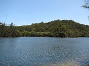
) to the East. - Along Middle HarbourMiddle HarbourMiddle Harbour is the northern arm of Port Jackson in Sydney, Australia.Middle Harbour extends about to the northwest, from where it joins the main harbour near the Heads. Its shore is nearly everywhere rugged, barren and forested and for this reason Middle Harbour was almost entirely neglected...
and Middle Harbour CreekMiddle Harbour Creek, New South WalesMiddle Harbour creek is a tributary into Middle Harbour Sydney, New South Wales. Located in the Garigal National Park the creek flows from Mona Vale Road in the north down to Bungaroo where the creek becomes middle harbour...
between (to the West) the suburbs of Killarney HeightsKillarney Heights, New South WalesKillarney Heights is a suburb of northern Sydney, in the state of New South Wales, Australia. Killarney Heights is located 15 kilometres north-east of the Sydney central business district in the local government area of Warringah Council...
, ForestvilleForestville, New South WalesForestville is a suburb of northern Sydney, in the state of New South Wales, Australia. Forestville is located 15 kilometres north-east of the Sydney central business district in the local government area of Warringah Council...
, Frenchs ForestFrenchs Forest, New South Wales-Commercial areas:Forestway shopping centre is at the intersection of Forestway and Warringah Roads. During the 1960s and 1970s, this centre had the name Arndale...
, DavidsonDavidson, New South WalesDavidson is a suburb of northern Sydney, in the state of New South Wales, Australia. Davidson is located 20 kilometres north-east of the Sydney central business district, in the local government area of Warringah Council...
, BelroseBelrose, New South WalesBelrose is a suburb of the northern beaches, Sydney in the state of New South Wales, Australia, 19 kilometres north-east of the Sydney central business district in the local government area of Warringah Council, and is part of the Northern Beaches region...
and (to the East) the suburbs of East LindfieldEast Lindfield, New South WalesEast Lindfield is a locality on the Upper North Shore of Sydney in the state of New South Wales, Australia. East Lindfield is located 13 kilometres north-west of the Sydney Central Business District in the local government area of Ku-ring-gai Council....
, East KillaraEast Killara, New South WalesEast Killara is a suburb on the Upper North Shore of Sydney in the state of New South Wales, Australia. East Killara is located 15 kilometres north-west of the Sydney Central Business District in the local government area of Ku-ring-gai Council. Killara is a separate suburb to the south-west.East...
, St IvesSt Ives, New South WalesSt Ives is a suburb on the Upper North Shore of Sydney in the state of New South Wales, Australia. St Ives is located 18 kilometres north of the Sydney Central Business District in the local government area of Ku-ring-gai Council...
, as far North as Mona Vale Road (where it abuts Ku-ring-gai Chase National ParkKu-ring-gai Chase National ParkKu-ring-gai Chase is a national park in New South Wales, Australia, 25 km north of Sydney located largely within the Ku-ring-gai, Hornsby, Warringah and Pittwater municipal areas. Ku-ring-gai Chase is also officially classed as a suburb by the Geographical Names Board of New South Wales...
). - To the South of Mona Vale Road the Park runs as far East as the suburb of Elanora and Narrabeen LagoonNarrabeen, New South WalesNarrabeen is a beachside suburb in northern Sydney, in the state of New South Wales, Australia. Narrabeen is located 23 kilometres north-east of the Sydney central business district, in the local government area of Warringah Council and is part of the Northern Beaches region.-History:There are a...
There are trails in this park popular with bushwalkers and mountain bike riders, particularly between Belrose and St Ives in an area known as Cascades after the Cascades Track that runs through here. Others trails include the Heath Track and Bare Creek Track.
Name
The name Garigal is taken from the clan of the Ku-ring-gai aboriginalIndigenous Australians
Indigenous Australians are the original inhabitants of the Australian continent and nearby islands. The Aboriginal Indigenous Australians migrated from the Indian continent around 75,000 to 100,000 years ago....
tribe that had lived in that area in times past.http://www.parliament.nsw.gov.au/prod/parlment/hansart.nsf/V3Key/LA19911115005
Fauna
Garigal is home to a wide range of fauna, including birds, snakes and a wide range of native mammals (bandicoots, koalas, wallabies).http://wildlifeatlas.nationalparks.nsw.gov.au/wildlifeatlas/watlasSpecies.jspThere is also a number of introduced pests, including rabbits and foxes.
Fact sheet
- Area: 22 km². This makes it the largest National Park in suburban Sydney.
- Coordinates: 33°42′21"S 151°14′11"E
- Date of establishment: 19 April 1991
- Managing authorities: New South Wales National Parks and Wildlife Service
- IUCNWorld Conservation UnionThe International Union for Conservation of Nature and Natural Resources is an international organization dedicated to finding "pragmatic solutions to our most pressing environment and development challenges." The organization publishes the IUCN Red List, compiling information from a network of...
category: II
External links
- National Parks page about Garigal
- Garigal Park Home Page
- List of fauna
- Detailed track notes and maps of most of the walks in Garigal NP
- The Northern Beaches Mountain Biking Group (NoBMoB) have details of trails around Cascades