

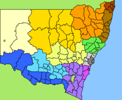
Local Government Areas of New South Wales
Encyclopedia

New South Wales
New South Wales is a state of :Australia, located in the east of the country. It is bordered by Queensland, Victoria and South Australia to the north, south and west respectively. To the east, the state is bordered by the Tasman Sea, which forms part of the Pacific Ocean. New South Wales...
, Australia
Australia
Australia , officially the Commonwealth of Australia, is a country in the Southern Hemisphere comprising the mainland of the Australian continent, the island of Tasmania, and numerous smaller islands in the Indian and Pacific Oceans. It is the world's sixth-largest country by total area...
have been subject to periodic bouts of restructuring and rationalisation by the State Government, involving voluntary and involuntary amalgamation of areas. The state government currently classifies local governments into two categories: Cities and Areas, there being little significant difference between the two (a City is simply an Area receiving a proclamation of city status by the Governor). Areas often retain the designations they held under pre-reform legislation, though these titles no longer indicate a legal status. These are:
- Municipalities (predominantly inner-city suburban areas and smaller rural towns)
- Shires (predominantly rural or outer suburban areas).
Some areas designated since the 1993 Local Government Act have adopted the title "Region", usually large rural areas dominated by a rural city. Many councils now choose not to use any area title, and simply refer to themselves as councils, e.g. Palerang Council, Burwood Council. The smallest local government area by area in the state is the Municipality of Hunter's Hill
Municipality of Hunter's Hill
The Municipality of Hunter's Hill is a Local Government Area in the Northern Suburbs of Sydney, and is the smallest Local Government Area in New South Wales by area. The mayor of Hunters Hill is Susan Hoopman.- Demographics :According to the , there:...
.
there are 152 local government areas in New South Wales. These are listed below in alphabetical order. In addition, there is also the Unincorporated Far West Region
Unincorporated Far West Region
The Unincorporated Far West Region is one of two areas of New South Wales which is not part of any Local Government Area ; it is in the Far West containing small towns such as Tibooburra , Milparinka , Silverton . Silverton and Tibooburra have village councils...
which is not part of any local government area, in the sparsely inhabited Far West, and Lord Howe Island
Lord Howe Island
Lord Howe Island is an irregularly crescent-shaped volcanic remnant in the Tasman Sea between Australia and New Zealand, directly east of mainland Port Macquarie, and about from Norfolk Island. The island is about 11 km long and between 2.8 km and 0.6 km wide with an area of...
, which is also unincorporated
Unincorporated area
In law, an unincorporated area is a region of land that is not a part of any municipality.To "incorporate" in this context means to form a municipal corporation, a city, town, or village with its own government. An unincorporated community is usually not subject to or taxed by a municipal government...
but self-governed by the Lord Howe Island Board.
Sydney
- Ashfield, Municipality ofMunicipality of AshfieldThe Municipality of Ashfield is a Local Government Area of Sydney, New South Wales, Australia. It lies approximately 10 kilometres west of the central business district.- Demographics :According to the , there:...
- Auburn CouncilAuburn CouncilAuburn Council is the governing body of a local government area in Sydney, New South Wales, Australia, about 15 kilometres west of the Sydney central business district...
- Bankstown, City ofCity of BankstownThe City of Bankstown is a city and Local Government Area in the Canterbury-Bankstown region of Sydney, New South Wales, Australia, centred on the suburb of Bankstown....
- Blacktown, City ofCity of BlacktownThe City of Blacktown is a Local Government Area in the heart of Western Sydney, situated on the Cumberland Plain, approximately 35 km from Sydney CBD. It is bounded by the Local Government Areas of Penrith, Parramatta, Fairfield, Holroyd, Hawkesbury and The Hills Shire. It occupies an area...
- Botany Bay, City ofCity of Botany BayThe City of Botany Bay is a Local Government Area in south eastern Sydney, in the state of New South Wales, Australia. It encompasses the suburbs to the north of Botany Bay, such as Botany. The administrative centre is located at Mascot, which is 7 km south of the Sydney central business...
- Burwood CouncilBurwood CouncilThe Municipality of Burwood is a Local Government Area in the inner-west of Sydney, in the state of New South Wales, Australia.- Suburbs in the local government area :Suburbs serviced by Burwood Council are:* Burwood* Burwood Heights* Enfield...
- Camden Council
- Campbelltown, City ofCity of Campbelltown, New South WalesThe City of Campbelltown is a Local Government Area in south-western Sydney, in the state of New South Wales, Australia, located about 55 km south west of the Sydney central business district. Australia...
- Canada Bay, City ofCity of Canada BayThe City of Canada Bay is a Local Government Area of New South Wales, Australia and located in the metropolitan area of Sydney. The city was formed in December 2000, following the merger of Concord and Drummoyne councils...
- Canterbury, City ofCity of Canterbury, New South WalesThe City of Canterbury, previously the Municipality of Canterbury, is a Local Government Area in Sydney, New South Wales, Australia. It lies southwest of the central business district and forms part of the Greater Sydney metropolitan area....
- Fairfield, City ofCity of FairfieldThe City of Fairfield is a Local Government Area in the south-west of Sydney, in the state of New South Wales, Australia.- Suburbs in the local government area :Suburbs in the City of Fairfield are:* Abbotsbury* Bonnyrigg* Bonnyrigg Heights* Bossley Park...
- The Hills Shire
- Holroyd, City ofCity of HolroydHolroyd is a Local Government Area and suburb of Sydney, New South Wales, Australia, located in the Western Sydney region. Originally known as the Municipality of Prospect and Sherwood it was incorporated in February 1872, in 1927 it was renamed the Municipality of Holroyd after Arthur Holroyd,...
- Hornsby ShireHornsby ShireHornsby Shire is a Local Government Area in the Northern region of Sydney, Australia. The Shire stretches from the suburb of Eastwood in the south to the Hawkesbury River town of Wisemans Ferry, some to the north...
- Hunter's Hill, Municipality ofMunicipality of Hunter's HillThe Municipality of Hunter's Hill is a Local Government Area in the Northern Suburbs of Sydney, and is the smallest Local Government Area in New South Wales by area. The mayor of Hunters Hill is Susan Hoopman.- Demographics :According to the , there:...
- Hurstville, City ofCity of HurstvilleThe City of Hurstville is a Local Government Area in southern Sydney, in the state of New South Wales, Australia. The city centre is located 17km SSW of the Sydney central business district and west of Botany Bay....
- Kogarah, Municipality ofMunicipality of KogarahThe Municipality of Kogarah is a Local Government Area in southern Sydney, in the state of New South Wales, Australia. The centre of the municipality is located 14km SSW of the Sydney central business district and west of Botany Bay....
- Ku-ring-gai CouncilKu-ring-gai CouncilKu-ring-gai Council is a Local Government Area in the North Shore region of Sydney. It includes the suburbs of Lindfield, Killara, Gordon, Pymble, St Ives, Turramurra, Warrawee, and parts of Roseville, and Wahroonga. The region is named after the Kuringgai tribe who once inhabited the area...
- Lane Cove, Municipality ofMunicipality of Lane CoveThe Municipality of Lane Cove is a Local Government Area located about 10km north-west of the central business district of Sydney, Australia, in the south-west corner of the North Shore. The Lane Cove River borders its south, with the eastern part of Hunter's Hill just across that river...
- Leichhardt, Municipality ofMunicipality of LeichhardtThe Municipality of Leichhardt is a Local Government Area in the inner-west of Sydney, in state of New South Wales, Australia.-History:The Municipality of Leichhardt stands on land that traditionally belonged to the Gadigal and Wangal people, of the Eora nation...
- Liverpool, City ofCity of Liverpool, New South WalesThe City of Liverpool is a Local Government Area to the southwest of Sydney, in the state of New South Wales, Australia.-History:It is one of the oldest urban settlements in Australia, founded in 1810 as an agricultural centre by Governor Lachlan Macquarie...
- Manly CouncilManly CouncilManly Council is a Local Government Area on the Northern Beaches of Sydney, in the state of New South Wales, Australia.- Demographics :According to the , there:...
- Marrickville CouncilMarrickville CouncilMarrickville Council is a Local Government Area situated in the Inner West region of Sydney, Australia.The area is bounded by Leichhardt to the north, the City of Sydney to the east and north-east, the City of Botany Bay to the south-east, Rockdale to the south, Canterbury to the west, and...
- Mosman, Municipality ofMunicipality of MosmanThe Municipality of Mosman is a Local Government Area on the Lower North Shore of Sydney, in the state of New South Wales, Australia.- Demographics :According to the Australian Bureau of Statistics...
- North Sydney CouncilNorth Sydney CouncilNorth Sydney Council is a Local Government Area on the North Shore of Sydney, in the state of New South Wales, Australia.- Demographics :According to the :...
- Parramatta, City ofCity of ParramattaThe City of Parramatta is a Local Government Area in western Sydney, in the state of New South Wales, Australia.Initially in 1861 it was formed as Municipality of Parramatta...
- Penrith, City ofCity of PenrithThe City of Penrith is a Local Government Area in Sydney, located about west of Sydney's central business district.- History :The Municipality of Penrith was incorporated on 12 May 1871 under the Municipalities Act 1858. On 3 March 1890, St Marys was separately incorporated, and on 26 July 1893...
- Pittwater CouncilPittwater CouncilPittwater Council is a Local Government Area on the Northern Beaches of Sydney, in the state of New South Wales, Australia. The suburbs which comprise the Pittwater LGA were detached from the Warringah local government area in 1993...
- Randwick, City ofCity of RandwickThe City of Randwick is a Local Government Area in the Eastern Suburbs of Sydney, in the state of New South Wales, Australia. One of Sydney's largest parks, Centennial Park, lies within the city boundary of Randwick. Other major landmarks in Randwick include the world-famous Randwick Racecourse,...
- Rockdale, City ofCity of RockdaleThe City of Rockdale is a Local Government Area in southern Sydney, in the state of New South Wales, Australia. The city centre is located 12 kilometres south-south-west of the Sydney central business district, on the western shores of Botany Bay...
- Ryde, City ofCity of RydeThe City of Ryde is a Local Government Area in Sydney, New South Wales, Australia, on the Lower North Shore and Greater Western Sydney over West Ryde and Eastwood District....
- Strathfield, Municipality ofMunicipality of StrathfieldThe Municipality of Strathfield is a Local Government Area of Sydney, New South Wales, Australia. The Municipality incorporates the suburbs of Flemington, Homebush, Homebush West, Strathfield South entirely, and shares the following suburbs with other Councils, Belfield, Greenacre, and Strathfield...
- Sutherland ShireSutherland ShireThe Sutherland Shire is a Local Government Area in the Southern Sydney region of Sydney, Australia. Geographically, it is the area to the south of Botany Bay and the Georges River...
- Sydney, City ofCity of SydneyThe City of Sydney is the Local Government Area covering the Sydney central business district and surrounding inner city suburbs of the greater metropolitan area of Sydney, Australia...
- Warringah CouncilWarringah CouncilWarringah is a local council area in the Northern Beaches region of Sydney, Australia. Warringah Council overlaps with a number of suburbs from the Manly Council area to the south and the Pittwater Council area to the north...
- Waverley Council
- Willoughby, City ofCity of WilloughbyThe City of Willoughby is a Local Government Area on the North Shore of Sydney, in the state of New South Wales, Australia. It is located 6 km north of the Sydney central business district....
- Woollahra, Municipality ofMunicipality of WoollahraThe Municipality of Woollahra is a Local Government Area in the Eastern Suburbs of Sydney, in the state of New South Wales, Australia. The administrative centre of the Municipality of Woollahra is located on New South Head Road at Double Bay....
Sydney Surrounds
- Blue Mountains, City ofCity of Blue MountainsThe City of Blue Mountains is a local government area of New South Wales, Australia, governed by the Blue Mountains City Council. The city is located in the Blue Mountains range west of Sydney.-Demographics:...
- Gosford, City of
- Hawkesbury, City ofCity of HawkesburyThe City of Hawkesbury is a Local Government Area of New South Wales, Australia, part of which is at the fringe of the Sydney metropolitan area, about 50 kilometres north-west of the Sydney central business district...
- Wollondilly Shire
- Wyong Shire
Mid-North Coast
- Bellingen Shire
- Clarence Valley Council
- Coffs Harbour, City ofCity of Coffs HarbourThe City of Coffs Harbour is the Local Government Area that administers the Coffs Harbour area. It is on the Pacific Highway, and the North Coast railway line.At the 2006 Census the City's resident population was 64,910...
- Greater Taree, City ofCity of Greater TareeThe City of Greater Taree is a Local Government Area on the Mid North Coast of New South Wales, Australia, centered on Taree. It is on the Manning River, the Pacific Highway and the North Coast railway line.- History :...
- Kempsey Shire
- Nambucca Shire
- Port Macquarie-Hastings Council
- Lord Howe IslandLord Howe IslandLord Howe Island is an irregularly crescent-shaped volcanic remnant in the Tasman Sea between Australia and New Zealand, directly east of mainland Port Macquarie, and about from Norfolk Island. The island is about 11 km long and between 2.8 km and 0.6 km wide with an area of...
Murray Region
- Albury, City ofCity of AlburyThe City of Albury is a Local Government Area in the Riverina region of New South Wales, Australia. The LGA covers the entirety of the Albury urban area including the suburbs of Forrest Hill, Lavington, Thurgoona, Splitters Creek, Ettamogah, Bowna, Table Top and Wirlinga.The LGA is administered...
- Balranald Shire
- Berrigan Shire
- Conargo Shire
- Corowa Shire
- Deniliquin CouncilDeniliquin CouncilDeniliquin Shire is a local government area in the Riverina region of New South Wales, Australia, close to the border with Victoria. It is the only rural local government area in New South Wales left consisting only of a rural town, and is surrounded by two rural local government areas .- Council...
- Greater Hume Shire
- Jerilderie Shire
- Murray Shire
- Tumbarumba Shire
- Urana Shire
- Wakool ShireWakool ShireWakool Shire is a Local Government Area located between the Murray River and the Murrumbidgee River and on the Sturt Highway.Towns in the Shire are: Barham , Moulamein , Tooleybuc , Wakool and Koraleigh.- Council :...
- Wentworth Shire
Murrumbidgee Region
- Carrathool ShireCarrathool ShireCarrathool Shire is a Local Government Area in the Far West of New South Wales on the Mid-Western Highway and north of the Sturt Highway.The largest town is Hillston and the council seat is Goolgowi...
- Coolamon Shire
- Cootamundra Shire
- Griffith, City ofCity of GriffithThe City of Griffith is a Local Government Area in south-western New South Wales, Australia. It is in the Murrumbidgee Irrigation Area and on Kidman Way....
- Gundagai Shire
- Hay Shire
- Junee Shire
- Leeton Shire
- Lockhart Shire
- Murrumbidgee Shire
- Narrandera Shire
- Temora Shire
- Wagga Wagga, City ofCity of Wagga WaggaThe Wagga Wagga City Council was formed from the amalgamation of City of Wagga Wagga with Mitchell and Kyeamba Shires in 1981. 22 December 2009, Wagga Wagga City Council announced that Phil Pinyon would be appointed as the General Manager of the Wagga Wagga City Council after Lyn Russell, who...
Hunter Region
- Cessnock, City ofCity of CessnockCessnock City Council is a Local Government Area in the Hunter Region of New South Wales, Australia, located to the west of Newcastle. The largest population centre and council seat is the city of Cessnock, after which the LGA is named....
- Dungog ShireDungog ShireDungog Shire is a Local Government Area in the Hunter Valley of New South Wales, Australia. It is situated in the Barrington Tops region and consists predominantly of very rugged to hilly country which becomes less rugged from north to south.- Incomes :...
- Gloucester ShireGloucester ShireGloucester Shire is a Local Government Area in New South Wales, Australia on the Mid North Coast. It is on the Bucketts Way and the North Coast railway line.- Incomes :According to the during 2003-04, there:...
- Great Lakes Council
- Lake Macquarie, City of
- Maitland, City ofCity of MaitlandThe City of Maitland is a Local Government Area in the Lower Hunter Region of New South Wales, Australia. It is on the New England Highway and CityRail's Hunter line.-Demographics:...
- Muswellbrook Shire
- Newcastle, City ofCity of NewcastleNewcastle City Council is a Local Government Area in the Hunter Region of New South Wales, Australia.-Demographics:According to the Australian Bureau Statistics the City of Newcastle had an estimated resident population of 154,777 as of 30 June 2008...
- Port Stephens Council
- Singleton Shire
- Upper Hunter Shire
Illawarra
- Kiama, Municipality of
- Shellharbour, City ofCity of ShellharbourCity of Shellharbour is a Local Government Area located in the Illawarra region, on the east coast of Australia, about 100 km south of Sydney...
- Shoalhaven, City of
- Wingecarribee Shire
- Wollongong, City ofCity of WollongongThe City of Wollongong is a Local Government Area in the Illawarra region of New South Wales, Australia. It is on the Pacific Ocean, the Southern Freeway and the South Coast railway line....
Richmond-Tweed
- Ballina Shire
- Byron ShireByron ShireByron Shire is a Local Government Area located in the North Coast region of New South Wales, Australia, on the Pacific Ocean coast between 50 and 80 kilometres south of the Queensland border. The shire, administered from the town of Mullumbimby, covers an area of , and has existed as a local...
- Kyogle CouncilKyogle CouncilKyogle Council is a Local Government Area in New South Wales, Australia in the Northern Rivers region. It is on the Summerland Way and the North Coast railway line.- Towns and localities :- Demographics :...
- Lismore, City ofCity of LismoreThe City of Lismore is a local government area in New South Wales, Australia. Its primary city, Lismore is a major regional centre in the Northern Rivers region of the state.-Demographics:...
- Richmond Valley Council
- Tweed Shire
South-Eastern Region
- Bega Valley Shire
- Bombala Shire
- Boorowa Shire
- Cooma-Monaro Shire
- Eurobodalla ShireEurobodalla ShireEurobodalla Shire is a Local Government Area in the state of New South Wales, Australia. It is located in a largely mountainous coastal region on the South Coast of New South Wales. It is on the Pacific Ocean, the Princes Highway and the Kings Highway....
- Goulburn Mulwaree CouncilGoulburn Mulwaree CouncilGoulburn Mulwaree Council is a Local Government Area of New South Wales, Australia. The council was formed as the Greater Argyle Council in 2004 as an amalgamation of Goulburn City and parts of the former Mulwaree Shire. It was renamed in 2005 following objections from the community...
- Harden Shire
- Palerang CouncilPalerang CouncilThe Palerang Council is a Local Government Area in the Southern Tablelands Region of New South Wales, Australia. It is on the Kings Highway and the Sydney-Canberra railway....
- Queanbeyan, City of
- Snowy River Shire
- Tumut Shire
- Upper Lachlan Shire
- Yass Valley Council
- Young Shire
Northern Region
- Armidale Dumaresq Shire
- Glen Innes Severn CouncilGlen Innes Severn CouncilGlen Innes Severn Council is the name of the Local Government Area in the New England region of New South Wales, Australia. It is on the New England Highway. It was formed by the amalgamation of Severn Shire and Glen Innes City Council.- Demographics :...
- Gunnedah Shire
- Guyra Shire
- Gwydir ShireGwydir ShireGwydir Shire is a Local Government Area located in the New England region of New South Wales, Australia along the state's border with Queensland...
- Inverell Shire
- Liverpool Plains Shire
- Moree Plains Shire
- Narrabri Shire
- Tamworth Regional CouncilTamworth Regional CouncilTamworth Regional Council is a Local Government Area in the New England region of New South Wales, Australia. It is on the New England Highway and the Main North railway line.- Incomes :According to the during 2003-04, there:...
- Tenterfield Shire
- Uralla Shire
- Walcha Shire
Central West
- Bathurst Regional CouncilBathurst Regional CouncilBathurst Regional Council administers the Bathurst Region Local Government Area in New South Wales, Australia. It is approximately 200 km west of Sydney and has a population of 37,001 . It is on the Great Western Highway, Mid-Western Highway, Mitchell Highway and the Main Western railway...
- Bland Shire
- Blayney Shire
- Cabonne Shire
- Cowra Shire
- Forbes Shire
- Lachlan ShireLachlan ShireLachlan Shire is a Local Government Area in the Central West of New South Wales on the Lachlan River and the Broken Hill railway line.The largest town and council seat is Condobolin. The Shire also includes the towns and villages of Tottenham, Lake Cargelligo, Tullibigeal, Albert, Burcher and...
- Lithgow, City ofCity of LithgowLithgow is a Local Government Area in New South Wales, Australia that includes Lithgow and its surrounding area. It is on the Great Western Highway and the Main Western railway line.- Demographics :According to the , there:...
- Mid-Western Regional Council
- Oberon Shire
- Orange, City ofCity of OrangeThe City of Orange is a Local Government Area of New South Wales, Australia, including Orange and the surrounding areas. It is on the Mitchell Highway and the Main Western railway line.It includes the villages of Lucknow, Shadforth, Spring Hill and March....
- Parkes Shire
- Weddin ShireWeddin ShireWeddin Shire is a Local Government Area in New South Wales, Australia. Its only significant town is Grenfell....
North Western Region
- Bogan Shire
- Bourke Shire
- Brewarrina Shire
- Cobar Shire
- Coonamble Shire
- Dubbo, City ofCity of DubboDubbo is a Local Government Area in the Orana region of New South Wales, Australia. The City is traversed by the Mitchell Highway, the Newell Highway, the Golden Highway and the Main Western railway line.The largest population centre is the city of Dubbo...
- Gilgandra Shire
- Narromine Shire
- Walgett Shire
- Warren ShireWarren ShireWarren Shire is a local government area in the Orana region of New South Wales, Australia. It is on the Macquarie River and the Mitchell and Oxley Highways. It is a wool and cotton growing area.Warren Shire includes Warren and Nevertire....
- Warrumbungle Shire
- Wellington CouncilWellington CouncilWellington Council is a local government area in the Orana region of New South Wales, Australia. It is on the Macquarie River and the Mitchell Highway....
Far West
- Broken Hill, City ofCity of Broken HillThe City of Broken Hill is the Local Government Area for Broken Hill, which is an isolated mining city in the far west of outback New South Wales, Australia, with a population of just under 20,000....
- Central Darling ShireCentral Darling ShireCentral Darling Shire is a Local Government Area in the Far West of New South Wales, Australia on the Barrier Highway. Central Darling Shire was constituted in 1959 and it is the largest Local Government Area in New South Wales.-Incomes:...
- Unincorporated Far West
External links
- New South Wales Department of Local Government Directory
- Map of Local Government Areas in New South Wales PDF, showing recent council amalgamations
- Clickable map of New South Wales LGAs (New South Wales Department of Local GovernmentNew South Wales Department of Local GovernmentThe New South Wales Division of Local Government, an agency of the Department of Premier and Cabinet in the Government of New South Wales, is responsible for administering legislation in relation to local government areas in New South Wales....
)