
Lake Lewis
Encyclopedia
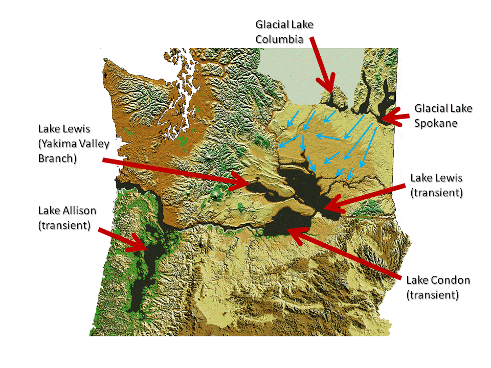
Lake Lewis was a temporary lake in the Pacific Northwest
region of North America
, largely formed by the Missoula Floods
in about the 14th millennium B.C.
Lake Lewis was formed when the restricted flow of waters from periodic cataclysmic floods from Glacial Lake Missoula
, pluvial Lake Bonneville
, and perhaps from subglacial outbursts, backed up through the constriction formed by the Wallula Gap
in the Horse Heaven Hills
(southern Washington). Water also backed up further downstream on the Columbia River
between Washington and Oregon
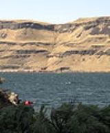
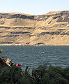
, delaying the drainage of Lake Lewis. The water remained for a period of weeks before the flood waters drained through Wallula Gap, just southeast of the Tri-Cities area. Lake Lewis reached an elevation of about 1200 feet (365.8 m) above sea level (today's sea level) before subsiding.
Lake Lewis also flooded the Yakima
, Walla Walla
, Touchet
and Tucannon
river valleys.
 During the last Ice Age (18,000 to 12,000 years ago), and in multiple previous glacial ages, cataclysmic floods inundated portions of the Pacific Northwest from Glacial Lake Missoula
, pluvial
Lake Bonneville
, and perhaps from subglacial outbursts. Glacial Lake Missoula was a body of water as large as some of the USA's Great Lakes
. This lake formed from glacial meltwater that was dammed by a lobe of the Canadian ice sheet. Episodically, perhaps every 40 to 140 years, the waters of this huge lake forced its way past the ice dam, inundating parts of the Pacific Northwest. Eventually, the ice receded northward far enough that the dam did not reform, and the flooding episodes ceased.
 Wallula Gap is a large water gap
through basalt anticline
s in the Columbia River
basin just south of the confluence of the Walla Walla River
and the Columbia River. The Wallula Gap, which has existed for many millions of years, was widened by the historic flow of the Salmon-Snake and Columbia Rivers combined with the glacial waters that poured across the Channeled Scablands
during the Missoula Floods. The Wallula Gap constrained the flow such that less than 1/5 of the 800 km³ of water per day entering could be discharged. As a result the floods filled the Pasco Basin and formed, for a short period, Lake Lewis. The large volumes of flood water passing through the gap contributed substantially to the erosion of the gap, as is evidenced by the shear walls and of scab-features such as the "Sisters."
Lake Lewis backflooded into the Yakima
, Walla Walla
, Touchet
and Tucannon
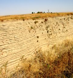
River Valleys. In these relatively calm arms of the lake, the slackwaters were thick with suspended materials eroded from the scablands above. Some of the suspended materials settled out, creating thick Touchet Formation layers which are found throughout these valleys.
The maximum elevation of the flood, as established by other indications, is confirmed by glacial erratics, which were stranded on the slopes of the Horse Heaven Hills
and other elevated regions in the mid-Columbia at elevations of up to 1200 feet (365.8 m) above sea level.
There were several long ridges (Saddle Mountains, Frenchman Hills, and Rattlesnake Mountain
) that were above flood level. Peaks like the Badger, Candy, and Red Mountains were islands. At this level, much of the Columbia Basin
would have been submerged.
Pacific Northwest
The Pacific Northwest is a region in northwestern North America, bounded by the Pacific Ocean to the west and, loosely, by the Rocky Mountains on the east. Definitions of the region vary and there is no commonly agreed upon boundary, even among Pacific Northwesterners. A common concept of the...
region of North America
North America
North America is a continent wholly within the Northern Hemisphere and almost wholly within the Western Hemisphere. It is also considered a northern subcontinent of the Americas...
, largely formed by the Missoula Floods
Missoula Floods
The Missoula Floods refer to the cataclysmic floods that swept periodically across eastern Washington and down the Columbia River Gorge at the end of the last ice age. The glacial flood events have been researched since the 1920s...
in about the 14th millennium B.C.
Lake Lewis was formed when the restricted flow of waters from periodic cataclysmic floods from Glacial Lake Missoula
Glacial Lake Missoula
Glacial Lake Missoula was a prehistoric proglacial lake in western Montana that existed periodically at the end of the last ice age between 15,000 and 13,000 years ago...
, pluvial Lake Bonneville
Lake Bonneville
Lake Bonneville was a prehistoric pluvial lake that covered much of North America's Great Basin region. Most of the territory it covered was in present-day Utah, though parts of the lake extended into present-day Idaho and Nevada. Formed about 32,000 years ago, it existed until about 14,500 years...
, and perhaps from subglacial outbursts, backed up through the constriction formed by the Wallula Gap
Wallula Gap
Wallula Gap is a large water gap of the Columbia River through basalt anticlines in the Columbia River Basin in the U.S. state of Washington, just south of the confluence of the Walla Walla and Columbia rivers...
in the Horse Heaven Hills
Horse Heaven Hills
The Horse Heaven Hills are a long range of high, rolling hills in Klickitat, Yakima, and Benton counties in Washington State located east of Satus Creek and west of the Columbia River between the Yakima River and the Wallula Gap. The hills are an anticline ridge in the Yakima fold belt formed by...
(southern Washington). Water also backed up further downstream on the Columbia River
Columbia River
The Columbia River is the largest river in the Pacific Northwest region of North America. The river rises in the Rocky Mountains of British Columbia, Canada, flows northwest and then south into the U.S. state of Washington, then turns west to form most of the border between Washington and the state...
between Washington and Oregon
Oregon
Oregon is a state in the Pacific Northwest region of the United States. It is located on the Pacific coast, with Washington to the north, California to the south, Nevada on the southeast and Idaho to the east. The Columbia and Snake rivers delineate much of Oregon's northern and eastern...
, delaying the drainage of Lake Lewis. The water remained for a period of weeks before the flood waters drained through Wallula Gap, just southeast of the Tri-Cities area. Lake Lewis reached an elevation of about 1200 feet (365.8 m) above sea level (today's sea level) before subsiding.
Lake Lewis also flooded the Yakima
Yakima River
The Yakima River is a tributary of the Columbia River in south central and eastern Washington State, named for the indigenous Yakama people. The length of the river from headwaters to mouth is , with an average drop of .-Course:...
, Walla Walla
Walla Walla River
The Walla Walla River is a tributary of the Columbia River, joining the Columbia just above Wallula Gap in southeastern Washington in the United States. The river flows through Umatilla County, Oregon and Walla Walla County, Washington. Its drainage basin is in area.-Course:The headwaters of the...
, Touchet
Touchet River
The Touchet River is the largest tributary of the Walla Walla River in southeastern Washington in the United States.The upper Touchet was a traditional summer meeting place for trade and games for the Palus, Nez Perce and Walla Walla tribes. The name Touchet derives from the similarly pronounced...
and Tucannon
Tucannon River
The Tucannon River is a river in southeastern Washington state that flows from headwaters in the Blue Mountains to a confluence with the Snake River upstream from Lyons Ferry Park and the mouth of the Palouse River. The Tucannon itself drains and is long...
river valleys.
Glacial Lake Missoula
Glacial Lake Missoula
Glacial Lake Missoula was a prehistoric proglacial lake in western Montana that existed periodically at the end of the last ice age between 15,000 and 13,000 years ago...
, pluvial
Pluvial lake
A pluvial lake is a landlocked basin which fills with rainwater during times of glaciation, when precipitation is higher. Pluvial lakes that have since evaporated and dried out may also be referred to as paleolakes.-Geology:...
Lake Bonneville
Lake Bonneville
Lake Bonneville was a prehistoric pluvial lake that covered much of North America's Great Basin region. Most of the territory it covered was in present-day Utah, though parts of the lake extended into present-day Idaho and Nevada. Formed about 32,000 years ago, it existed until about 14,500 years...
, and perhaps from subglacial outbursts. Glacial Lake Missoula was a body of water as large as some of the USA's Great Lakes
Great Lakes
The Great Lakes are a collection of freshwater lakes located in northeastern North America, on the Canada – United States border. Consisting of Lakes Superior, Michigan, Huron, Erie, and Ontario, they form the largest group of freshwater lakes on Earth by total surface, coming in second by volume...
. This lake formed from glacial meltwater that was dammed by a lobe of the Canadian ice sheet. Episodically, perhaps every 40 to 140 years, the waters of this huge lake forced its way past the ice dam, inundating parts of the Pacific Northwest. Eventually, the ice receded northward far enough that the dam did not reform, and the flooding episodes ceased.
Wallula Gap
Water gap
A water gap is an opening or notch which flowing water has carved through a mountain range. Water gaps often offer a practical route for road and rail transport to cross mountain ridges.- Geology :...
through basalt anticline
Anticline
In structural geology, an anticline is a fold that is convex up and has its oldest beds at its core. The term is not to be confused with antiform, which is a purely descriptive term for any fold that is convex up. Therefore if age relationships In structural geology, an anticline is a fold that is...
s in the Columbia River
Columbia River
The Columbia River is the largest river in the Pacific Northwest region of North America. The river rises in the Rocky Mountains of British Columbia, Canada, flows northwest and then south into the U.S. state of Washington, then turns west to form most of the border between Washington and the state...
basin just south of the confluence of the Walla Walla River
Walla Walla River
The Walla Walla River is a tributary of the Columbia River, joining the Columbia just above Wallula Gap in southeastern Washington in the United States. The river flows through Umatilla County, Oregon and Walla Walla County, Washington. Its drainage basin is in area.-Course:The headwaters of the...
and the Columbia River. The Wallula Gap, which has existed for many millions of years, was widened by the historic flow of the Salmon-Snake and Columbia Rivers combined with the glacial waters that poured across the Channeled Scablands
Channeled scablands
The Channeled Scablands are a unique geological erosion feature in the U.S. state of Washington. They were created by the cataclysmic Missoula Floods that swept periodically across eastern Washington and down the Columbia River Plateau during the Pleistocene epoch. Geologist J Harlen Bretz coined...
during the Missoula Floods. The Wallula Gap constrained the flow such that less than 1/5 of the 800 km³ of water per day entering could be discharged. As a result the floods filled the Pasco Basin and formed, for a short period, Lake Lewis. The large volumes of flood water passing through the gap contributed substantially to the erosion of the gap, as is evidenced by the shear walls and of scab-features such as the "Sisters."
Touchet Formation
Lake Lewis backflooded into the Yakima
Yakima River
The Yakima River is a tributary of the Columbia River in south central and eastern Washington State, named for the indigenous Yakama people. The length of the river from headwaters to mouth is , with an average drop of .-Course:...
, Walla Walla
Walla Walla River
The Walla Walla River is a tributary of the Columbia River, joining the Columbia just above Wallula Gap in southeastern Washington in the United States. The river flows through Umatilla County, Oregon and Walla Walla County, Washington. Its drainage basin is in area.-Course:The headwaters of the...
, Touchet
Touchet River
The Touchet River is the largest tributary of the Walla Walla River in southeastern Washington in the United States.The upper Touchet was a traditional summer meeting place for trade and games for the Palus, Nez Perce and Walla Walla tribes. The name Touchet derives from the similarly pronounced...
and Tucannon
Tucannon River
The Tucannon River is a river in southeastern Washington state that flows from headwaters in the Blue Mountains to a confluence with the Snake River upstream from Lyons Ferry Park and the mouth of the Palouse River. The Tucannon itself drains and is long...
River Valleys. In these relatively calm arms of the lake, the slackwaters were thick with suspended materials eroded from the scablands above. Some of the suspended materials settled out, creating thick Touchet Formation layers which are found throughout these valleys.
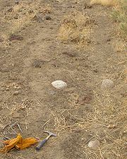
Glacial erratics
The maximum elevation of the flood, as established by other indications, is confirmed by glacial erratics, which were stranded on the slopes of the Horse Heaven Hills
Horse Heaven Hills
The Horse Heaven Hills are a long range of high, rolling hills in Klickitat, Yakima, and Benton counties in Washington State located east of Satus Creek and west of the Columbia River between the Yakima River and the Wallula Gap. The hills are an anticline ridge in the Yakima fold belt formed by...
and other elevated regions in the mid-Columbia at elevations of up to 1200 feet (365.8 m) above sea level.
There were several long ridges (Saddle Mountains, Frenchman Hills, and Rattlesnake Mountain
Rattlesnake Mountain, Benton County, Washington
Rattlesnake Mountain is a 3,527 ft windswept treeless sub-alpine ridge overlooking the Hanford nuclear site...
) that were above flood level. Peaks like the Badger, Candy, and Red Mountains were islands. At this level, much of the Columbia Basin
Columbia Basin
The Columbia Basin, the drainage basin of the Columbia River, occupies a large area–about —of the Pacific Northwest region of North America. In common usage, the term often refers to a smaller area, generally the portion of the drainage basin that lies within eastern Washington.Usage of the term...
would have been submerged.