
West Melbourne, Victoria
Encyclopedia
West Melbourne is an inner city
suburb of Melbourne
, Victoria
, Australia
, 3 km north-west from Melbourne's central business district
. Its Local Government Area is the City of Melbourne
. At the 2006 Census, West Melbourne had a population of 3037.
West Melbourne is bounded by Victoria Street and the Footscray Rail line in the North, Footscray Road and the Moonee Ponds Creek
and the Yarra River
in the south. Peel Street and the Flagstaff Gardens
help form the Eastern Boundary, with the Western Boundary defined by the Maribyrnong River
and Coode Island, a locality of West Melbourne which is home to Victoria's largest toxic chemical storage facility.
Being largely an industrial area, a significant portion of West Melbourne is occupied by the Port of Melbourne
, the Dynon railway yards and the Melbourne Markets
. These include the Wholesale Fruit and Vegetable and Fish Markets as well as the National Flower Centre. It also contains a small pocket of residential and commercial properties, consisting of a mixture of Victorian single and double storey terrace houses and converted warehouses at the north-west corner of the Melbourne CBD
.
It is also home to the Queen Victoria Market
located on corner of Victoria and Peel Streets.
is actually situated in West Melbourne, opposite the Railway Hotel on Ireland Street.
A number of tram routes
run along the periphery of the suburb, along Victoria Street, Peel/William Street and LaTrobe Street.
is a locality in West Melbourne's industrial zone. It is unusual in that although it is a locality of West Melbourne, with the creation of Melbourne Docklands
and Bolte Bridge
the area has become completely disonnected from the main area of the suburb.
It is the site of Victoria's major petrochemical
storage facility. The area is named after engineer John Coode
and retains the "Island" name despite no longer being an island
.
Inner city
The inner city is the central area of a major city or metropolis. In the United States, Canada, United Kingdom and Ireland, the term is often applied to the lower-income residential districts in the city centre and nearby areas...
suburb of Melbourne
Melbourne
Melbourne is the capital and most populous city in the state of Victoria, and the second most populous city in Australia. The Melbourne City Centre is the hub of the greater metropolitan area and the Census statistical division—of which "Melbourne" is the common name. As of June 2009, the greater...
, Victoria
Victoria (Australia)
Victoria is the second most populous state in Australia. Geographically the smallest mainland state, Victoria is bordered by New South Wales, South Australia, and Tasmania on Boundary Islet to the north, west and south respectively....
, Australia
Australia
Australia , officially the Commonwealth of Australia, is a country in the Southern Hemisphere comprising the mainland of the Australian continent, the island of Tasmania, and numerous smaller islands in the Indian and Pacific Oceans. It is the world's sixth-largest country by total area...
, 3 km north-west from Melbourne's central business district
Melbourne city centre
Melbourne City Centre is an area of Melbourne in Victoria, Australia. It is not to be confused with the larger local government area of the City of Melbourne...
. Its Local Government Area is the City of Melbourne
City of Melbourne
The City of Melbourne is a Local Government Area in Victoria, Australia, located in the central city area of Melbourne. The city has an area of 36 square kilometres and has an estimated population of 93,105 people. The city's motto is "Vires acquirit eundo" which means "She gathers strength as she...
. At the 2006 Census, West Melbourne had a population of 3037.
West Melbourne is bounded by Victoria Street and the Footscray Rail line in the North, Footscray Road and the Moonee Ponds Creek
Moonee Ponds Creek
The Moonee Ponds Creek is a creek and major tributary of the Yarra River running through urban Melbourne, Victoria, Australia from northern to inner suburbs...
and the Yarra River
Yarra River
The Yarra River, originally Birrarung, is a river in east-central Victoria, Australia. The lower stretches of the river is where the city of Melbourne was established in 1835 and today Greater Melbourne dominates and influences the landscape of its lower reaches...
in the south. Peel Street and the Flagstaff Gardens
Flagstaff Gardens, Melbourne
Flagstaff Gardens is the oldest park in Melbourne, Victoria, Australia, first established in 1862. In 2005 it is one of the most visited and widely used parks in the city by nearby office workers and tourists...
help form the Eastern Boundary, with the Western Boundary defined by the Maribyrnong River
Maribyrnong river
The Maribyrnong River rises about 50 km north of Melbourne, Victoria , near Mount Macedon. It flows generally southward and combines with the Yarra River to flow into Port Phillip....
and Coode Island, a locality of West Melbourne which is home to Victoria's largest toxic chemical storage facility.
Being largely an industrial area, a significant portion of West Melbourne is occupied by the Port of Melbourne
Port of Melbourne
The Port of Melbourne is Australia's busiest port for containerised and general cargo. It is located in Melbourne, Victoria and covers an area at the mouth of the Yarra River, downstream of Bolte Bridge, which is at the head of Port Phillip, as well as several piers on the bay itself...
, the Dynon railway yards and the Melbourne Markets
Melbourne Markets
The Melbourne Markets relates to the Wholesale Fruit and Vegetable Market operated by the Melbourne Market Authority.The Melbourne Markets complex contains the:* Wholesale Fruit and Vegetable Market* National Flower Centre* Nursery Market...
. These include the Wholesale Fruit and Vegetable and Fish Markets as well as the National Flower Centre. It also contains a small pocket of residential and commercial properties, consisting of a mixture of Victorian single and double storey terrace houses and converted warehouses at the north-west corner of the Melbourne CBD
Central business district
A central business district is the commercial and often geographic heart of a city. In North America this part of a city is commonly referred to as "downtown" or "city center"...
.
It is also home to the Queen Victoria Market
Queen Victoria Market
The Queen Victoria Market is a major landmark in Melbourne, Australia, and at around seven hectares is the largest open air market in the Southern Hemisphere. The Market is significant to Melbourne's culture and heritage and has been listed on the Victorian Heritage Register...
located on corner of Victoria and Peel Streets.
History
West Melbourne Post Office opened on 1 March 1937 and was replaced by the Queen Vic Market Newsagency office in 1990 which closed in 1996.Transport
The North Melbourne railway stationNorth Melbourne railway station
North Melbourne is a railway station located on the northern edge of the central business district of Melbourne, Australia. The station is the point through which pass the west and north-west bound Craigieburn, Flemington Racecourse, Sydenham, Upfield, Werribee and Williamstown suburban railway...
is actually situated in West Melbourne, opposite the Railway Hotel on Ireland Street.
- 401 North MelbourneNorth Melbourne, VictoriaNorth Melbourne is a large inner city suburb of Melbourne, Victoria, Australia, 2 km north-west from Melbourne's central business district. It is bounded by the CityLink freeway to the west, Victoria Street to the south, O'Connell and Peel Streets to the east and Flemington Road to the north. Its...
– University of MelbourneUniversity of MelbourneThe University of Melbourne is a public university located in Melbourne, Victoria. Founded in 1853, it is the second oldest university in Australia and the oldest in Victoria...
via Royal Melbourne Hospital, University of Melbourne (Monday to Friday). Operated by Sita Bus Lines.
A number of tram routes
Trams in Melbourne
The Melbourne tramway network is a major form of public transport in Melbourne, the capital city of the state of Victoria, Australia. , the network consisted of of track, 487 trams, 28 routes, and 1,773 tram stops. It was therefore the largest urban tramway network in the world, ahead of the...
run along the periphery of the suburb, along Victoria Street, Peel/William Street and LaTrobe Street.
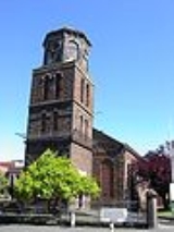
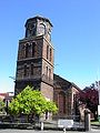
Churches
- West Melbourne Baptist
- St Mary Star of the SeaSt Mary Star of the Sea, West MelbourneSt Mary Star of the Sea is one of the most beautiful and historically significant churches in Australia. Originally with seating for over 1200 people, it has been described as the largest parish church in Melbourne, in Victoria, or even in Australia.- History :...
Catholic - St James Old CathedralSt James Old Cathedralthumb|300px|St James Old Cathedral, MelbourneSt James Old Cathedral, an Anglican church, is the oldest church in Melbourne, Australia, and one of only three buildings in the central city which predate the Gold Rush of 1851...
(Melbourne's oldest cathedral, built in 1842) - St Mary's Anglican
Hotels
- Carron Tavern, Spencer Street
- McMahons Hotel (Moomba Hotel, formerly North West Hotel), Spencer Street
- Railway Hotel, Ireland Street
- Royal Mail Hotel (formerly Maitz), Spencer Street
- Royal Standard Hotel, William Street
- Hotel Spencer, Spencer Street
- Three Crowns Hotel, Victoria Street
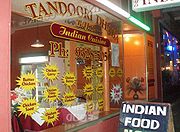
Restaurants
- Citrus Mint
- Kathmandu Cottage
- Warung Agus
- Le Taj
- Wild East
- Amiconi
- Fraus
- Tandoori Dhaba
Parks and gardens
- Flagstaff Gardens
- The Triangle Park (bounded by King St, Chetwynd St, Eades Place)
- The Pocket Park (bounded by William, Howard and Rosslyn Sts)
North of the railway lines
The area bounded by Railway Parade and Spencer St has undergone significant change since 2000. While the region has always been mixed industry and residential, the industrial flavour of the area has diminished rapidly, as West Melbourne's population increases. In Dryburgh, Laurens, Ireland, Stanley and Adderley Streets, the majority of the warehouses have been converted to townhouse developments. The development nearby of the Docklands has had a significant impact on the perceived prestige of the area, and it is rapidly losing its status as one of the most affordable precincts with such proximity to the CBD.Shopping
West Melbourne lays claim to the southern side of Victoria Street, meaning that a small range of restaurants and shops lie within its boundaries. Otherwise it has no shopping area of its own. However the Direct Factory Outlet development on Spencer St in the CBD, and Errol St North Melbourne sit just outside the boundary of West Melbourne.Coode Island
Coode IslandCoode Island
Coode Island, was an island at the convergence of the Yarra and Maribyrnong Rivers, 4km west of central Melbourne, Australia. Today the low-lying land is part of the Port of Melbourne, site of Swanson and Appleton Docks and their associated container storage and rail yards, as well as a number of...
is a locality in West Melbourne's industrial zone. It is unusual in that although it is a locality of West Melbourne, with the creation of Melbourne Docklands
Melbourne Docklands
Docklands is an inner city suburb in Melbourne, Victoria, Australia occupying an area extending up to 2 km west of and adjacent to Melbourne's Central Business District . Its Local Government Area is the City of Melbourne...
and Bolte Bridge
Bolte Bridge
The Bolte Bridge is a large twin Cantilever bridge in Melbourne, Victoria, Australia. It spans the Yarra River and Victoria Harbour in the Docklands precinct to the west of the Melbourne CBD...
the area has become completely disonnected from the main area of the suburb.
It is the site of Victoria's major petrochemical
Petrochemical
Petrochemicals are chemical products derived from petroleum. Some chemical compounds made from petroleum are also obtained from other fossil fuels, such as coal or natural gas, or renewable sources such as corn or sugar cane....
storage facility. The area is named after engineer John Coode
John Coode (engineer)
Sir John Coode , English civil engineer, was born at Bodmin, Cornwall, the son of a solicitor. After considerable experience as an engineer in the west of England he came to London, and from 1844 to 1847 had a consulting practice in Westminster.In the latter year he was appointed resident engineer...
and retains the "Island" name despite no longer being an island
Island
An island or isle is any piece of sub-continental land that is surrounded by water. Very small islands such as emergent land features on atolls can be called islets, cays or keys. An island in a river or lake may be called an eyot , or holm...
.
External links
- Local history of West Melbourne
- http://www.melbourne.vic.gov.au/info.cfm?top=66&pa=779&pg=1386