
North Melbourne, Victoria
Encyclopedia
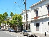
North Melbourne is a large inner city
suburb of Melbourne
, Victoria
, Australia
, 2 km north-west from Melbourne's central business district
. It is bounded by the CityLink
freeway to the west, Victoria Street to the south, O'Connell and Peel Streets to the east and Flemington Road to the north. Its Local Government Area are the Cities of Melbourne
and Moonee Valley
. At the 2006 Census, North Melbourne had a population of 9,962.
Formerly known as Hotham, it was a working class area and was one of the first towns in Victoria to be granted municipal status.
Today it continues to undergo gentrification
, noted for its Victorian architecture, cosmopolitan demographic, commercial and older industrial areas.
and Royal Park
as part of West Melbourne
.
In the 1850s a Benevolent Asylum was built between Abbotsford and Curzon Streets, coinciding with the desire to find space to accommodate the growing population from the gold rush
. In 1859 the area was named Hotham borough, after the governor of Victoria Charles Hotham
. Hotham Post Office opened on 20 March 1860.
By 1861, Hotham had a population of over 7,000.
In 1869 some of these decided to form the Hotham Football Club that later became a foundation member of the VFA
(Australian rules football
) today known as the North Melbourne Kangaroos.
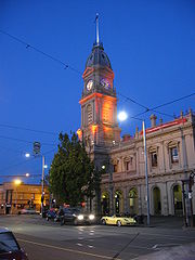
On the 26 August 1887 the borough was renamed North Melbourne Town after the completion of the imposing North Melbourne Town Hall
and the Metropolitan Meat Market
During the 1880s it had become a predominantly working class area with most of the male population employed in local industry.
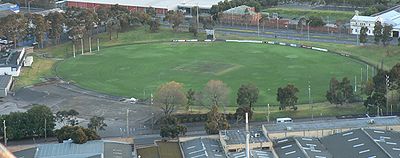
In the 1890s tram routes had entered the area as far as Abbotsford Street, walking distance from the Arden Street Oval
.
In the 1930s many areas of North Melbourne, in particular the laneways, became overcrowded and defined as slums. As such, large government housing development
projects were proposed, which were eventually completed in the 1960s.
 The main shopping strip of Errol Street situated around the old North Melbourne Town Hall.
Since the 1990s it has become something of an upmarket strip, home to a number of popular cafes and boutiques.
and Eritrea
.
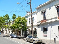 The predominant housing types are old Victorian-style terrace houses and Housing Commission of Victoria
flats, some hi-rise.
North Melbourne has been slower to gentrify than other inner suburbs, due to established families resisting the sale of their homes for decades. A younger generation finally began to move in in the 1980s, capitalising on the proximity to the Melbourne City Centre. Many of the old factories and warehouses were converted into fashionable loft-style apartments in 1990s. Since 2000, there has been a large increase in new medium density apartment complexes being built.
House prices now exceed Melbourne's median.
The heritage listed town hall and former Meat Market are both theatre and arts spaces.
 The North Melbourne Football Club
is still active and plays in the national Australian football competition, the Australian Football League
. The club's football department and training sessions are based at its traditional home ground at Arden Street Oval
, which has recently been redeveloped.
However, there remains a large Catholic school presence in the area, with several campuses and colleges continuing to operate.
List of restaurants:
Clothing shops:
 Major roads include Flemington Road, Elizabeth Street
and Victoria Street.
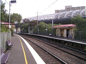
The main railway station is Flemington Bridge which is on the Upfield railway line. Despite the naming, the North Melbourne railway station
is actually in the adjacent suburb of West Melbourne
, while the Flemington Bridge railway station is in North Melbourne boundaries and not in Flemington.
It is serviced by tram routes:
It also has bus routes.
Inner city
The inner city is the central area of a major city or metropolis. In the United States, Canada, United Kingdom and Ireland, the term is often applied to the lower-income residential districts in the city centre and nearby areas...
suburb of Melbourne
Melbourne
Melbourne is the capital and most populous city in the state of Victoria, and the second most populous city in Australia. The Melbourne City Centre is the hub of the greater metropolitan area and the Census statistical division—of which "Melbourne" is the common name. As of June 2009, the greater...
, Victoria
Victoria (Australia)
Victoria is the second most populous state in Australia. Geographically the smallest mainland state, Victoria is bordered by New South Wales, South Australia, and Tasmania on Boundary Islet to the north, west and south respectively....
, Australia
Australia
Australia , officially the Commonwealth of Australia, is a country in the Southern Hemisphere comprising the mainland of the Australian continent, the island of Tasmania, and numerous smaller islands in the Indian and Pacific Oceans. It is the world's sixth-largest country by total area...
, 2 km north-west from Melbourne's central business district
Melbourne city centre
Melbourne City Centre is an area of Melbourne in Victoria, Australia. It is not to be confused with the larger local government area of the City of Melbourne...
. It is bounded by the CityLink
CityLink
CityLink is a system of tolled urban Highways in Melbourne, Victoria, Australia. The company Transurban was awarded the contract to augment two existing freeways and construct two new Toll roads—labelled the Western and Southern Links—directly linking a number of existing freeways to...
freeway to the west, Victoria Street to the south, O'Connell and Peel Streets to the east and Flemington Road to the north. Its Local Government Area are the Cities of Melbourne
City of Melbourne
The City of Melbourne is a Local Government Area in Victoria, Australia, located in the central city area of Melbourne. The city has an area of 36 square kilometres and has an estimated population of 93,105 people. The city's motto is "Vires acquirit eundo" which means "She gathers strength as she...
and Moonee Valley
City of Moonee Valley
The City of Moonee Valley is a Local Government Area located within the metropolitan area of Melbourne, Victoria, Australia. It comprises the north-western suburbs between 3 and 13 kilometres from the Melbourne city centre...
. At the 2006 Census, North Melbourne had a population of 9,962.
Formerly known as Hotham, it was a working class area and was one of the first towns in Victoria to be granted municipal status.
Today it continues to undergo gentrification
Gentrification
Gentrification and urban gentrification refer to the changes that result when wealthier people acquire or rent property in low income and working class communities. Urban gentrification is associated with movement. Consequent to gentrification, the average income increases and average family size...
, noted for its Victorian architecture, cosmopolitan demographic, commercial and older industrial areas.
History
North Melbourne's first institutions were built in the 1840s, beginning with a cattle yard. At this time the area was not well defined and included ParkvilleParkville, Victoria
Parkville is an inner city suburb in Melbourne, Victoria, Australia, 3 km north from Melbourne's central business district. Its Local Government Area is the City of Melbourne. At the 2006 Census, the population was 4,980....
and Royal Park
Royal Park, Melbourne
Royal Park is the largest of Melbourne's inner city parks . It is located north of the Melbourne Central Business District, Victoria, Australia, in the suburb of Parkville....
as part of West Melbourne
West Melbourne
West Melbourne may refer to:*West Melbourne, Florida, United States*West Melbourne, Victoria, Australia...
.
In the 1850s a Benevolent Asylum was built between Abbotsford and Curzon Streets, coinciding with the desire to find space to accommodate the growing population from the gold rush
Victorian gold rush
The Victorian gold rush was a period in the history of Victoria, Australia approximately between 1851 and the late 1860s. In 10 years the Australian population nearly tripled.- Overview :During this era Victoria dominated the world's gold output...
. In 1859 the area was named Hotham borough, after the governor of Victoria Charles Hotham
Charles Hotham
Sir Charles Hotham, KCB, RN was Lieutenant-governor and, later, Governor of Victoria, Australia from 22 June 1854 to 10 November 1855.-Early life:...
. Hotham Post Office opened on 20 March 1860.
By 1861, Hotham had a population of over 7,000.
In 1869 some of these decided to form the Hotham Football Club that later became a foundation member of the VFA
Victorian Football League
The Victorian Football League which evolved from the former Victorian Football Association , taking its new name as from the 1996 season, is the premier Australian rules football league in Victoria The Victorian Football League (VFL) which evolved from the former Victorian Football Association...
(Australian rules football
Australian rules football
Australian rules football, officially known as Australian football, also called football, Aussie rules or footy is a sport played between two teams of 22 players on either...
) today known as the North Melbourne Kangaroos.
On the 26 August 1887 the borough was renamed North Melbourne Town after the completion of the imposing North Melbourne Town Hall
North Melbourne Town Hall
North Melbourne Town Hall is the former town hall of the Town of Hotham in the state of Victoria. It is listed in the register of the National Trust...
and the Metropolitan Meat Market
During the 1880s it had become a predominantly working class area with most of the male population employed in local industry.
In the 1890s tram routes had entered the area as far as Abbotsford Street, walking distance from the Arden Street Oval
Arden Street Oval
Arden Street Oval is a sports oval based in Arden Street, North Melbourne, Victoria, Australia. It is currently the training base of Australian rules team North Melbourne Football Club and up to the end of the 1985 season it was used for elite-level VFL/AFL matches.-History:The North Melbourne...
.
In the 1930s many areas of North Melbourne, in particular the laneways, became overcrowded and defined as slums. As such, large government housing development
Public housing
Public housing is a form of housing tenure in which the property is owned by a government authority, which may be central or local. Social housing is an umbrella term referring to rental housing which may be owned and managed by the state, by non-profit organizations, or by a combination of the...
projects were proposed, which were eventually completed in the 1960s.
Commercial Centre
Since the 1990s it has become something of an upmarket strip, home to a number of popular cafes and boutiques.
Demographics
It has a strong migrant mix, being a popular destination for low income families for decades. More recent arrivals are refugees from countries such as SomaliaSomalia
Somalia , officially the Somali Republic and formerly known as the Somali Democratic Republic under Socialist rule, is a country located in the Horn of Africa. Since the outbreak of the Somali Civil War in 1991 there has been no central government control over most of the country's territory...
and Eritrea
Eritrea
Eritrea , officially the State of Eritrea, is a country in the Horn of Africa. Eritrea derives it's name from the Greek word Erethria, meaning 'red land'. The capital is Asmara. It is bordered by Sudan in the west, Ethiopia in the south, and Djibouti in the southeast...
.
Religion
Curzon Street Church (now known as St Mark the Evangelist), St Mary's Anglican Church, and the ornate Ukrainian Catholic Cathedral, built in 1963 on the high section of Dryburgh Street.Housing
Housing Commission of Victoria
The Housing Commission of Victoria was a State Government body responsible for public housing in Victoria, Australia...
flats, some hi-rise.
North Melbourne has been slower to gentrify than other inner suburbs, due to established families resisting the sale of their homes for decades. A younger generation finally began to move in in the 1980s, capitalising on the proximity to the Melbourne City Centre. Many of the old factories and warehouses were converted into fashionable loft-style apartments in 1990s. Since 2000, there has been a large increase in new medium density apartment complexes being built.
House prices now exceed Melbourne's median.
Culture
"Spring Fling" is an annual festival for North and West Melbourne.The heritage listed town hall and former Meat Market are both theatre and arts spaces.
Sport
North Melbourne Football Club
The North Melbourne Football Club, nicknamed The Kangaroos, is the fourth oldest Australian rules football club in the Australian Football League and is one of the oldest sporting clubs in Australia and the world...
is still active and plays in the national Australian football competition, the Australian Football League
Australian Football League
The Australian Football League is both the governing body and the major professional competition in the sport of Australian rules football...
. The club's football department and training sessions are based at its traditional home ground at Arden Street Oval
Arden Street Oval
Arden Street Oval is a sports oval based in Arden Street, North Melbourne, Victoria, Australia. It is currently the training base of Australian rules team North Melbourne Football Club and up to the end of the 1985 season it was used for elite-level VFL/AFL matches.-History:The North Melbourne...
, which has recently been redeveloped.
Schools and Education
While three state schools existed in North Melbourne in 1900, only one, Errol Street Primary School, remains. There is an all girls high school, in Curran Street, St. Aloysius College, in North Melbourne.However, there remains a large Catholic school presence in the area, with several campuses and colleges continuing to operate.
Restaurants and Shopping Centre
North Melbourne has few streets in Errol Street and Victoria Street that has restaurants, clothing shops and commerical retail stores.List of restaurants:
- Sushi Noodle Town
- Ferguson Plarre Bakhouses
- Baker's Delight
- Errol's
- Toast Cafe
Clothing shops:
- Salvos Store
Transport
Elizabeth Street, Melbourne
Elizabeth Street is one of the main north-south streets in the central business district of Melbourne, Australia, part of the Hoddle Grid laid out in 1837.- Geography :...
and Victoria Street.
The main railway station is Flemington Bridge which is on the Upfield railway line. Despite the naming, the North Melbourne railway station
North Melbourne railway station
North Melbourne is a railway station located on the northern edge of the central business district of Melbourne, Australia. The station is the point through which pass the west and north-west bound Craigieburn, Flemington Racecourse, Sydenham, Upfield, Werribee and Williamstown suburban railway...
is actually in the adjacent suburb of West Melbourne
West Melbourne, Victoria
West Melbourne is an inner city suburb of Melbourne, Victoria, Australia, 3 km north-west from Melbourne's central business district. Its Local Government Area is the City of Melbourne...
, while the Flemington Bridge railway station is in North Melbourne boundaries and not in Flemington.
It is serviced by tram routes:
- Tram route 59Melbourne tram route 59Tram route 59 is a public transport service in Melbourne, Victoria, Australia. It runs from the intersection of Flinders Street and Elizabeth Street in the city centre to Airport West in the north western suburbs....
(Airport WestAirport West, VictoriaAirport West is a suburb 14 km north-west of Melbourne, Victoria, Australia. Its Local Government Area is the City of Moonee Valley. At the 2006 Census, Airport West had a population of 6660....
): travels along Elizabeth Street and down Flemington RoadFlemington Road, MelbourneFlemington Road is a major thoroughfare in the inner suburbs of North Melbourne and Parkville in Melbourne, Victoria, Australia. It runs from the north end of Elizabeth Street to the south end of Mount Alexander Road, Flemington, and provides a main connection between the Melbourne CBD and the... - Tram route 57Melbourne tram route 57Tram route 57 is a public transport service in Melbourne, Victoria, Australia. It runs from the corner of Flinders Street and Elizabeth Street in the city centre to West Maribyrnong in the inner Western suburbs....
(West MaribyrnongMaribyrnong, VictoriaMaribyrnong is a suburb 8 km north-west of Melbourne, Victoria, Australia. Its Local Government Area is the City of Maribyrnong, part of River Ward. At the 2006 Census, Maribyrnong had a population of 8242....
): travels along Victoria, Errol, Queensberry and Abbotsford Streets, then down Flemington Road - Tram route 55Melbourne tram route 55Tram route 55 is a public transport service in Melbourne, Victoria, Australia. It runs from the corner of Bell Street and Melville Road in West Coburg to the Domain Road Interchange - Domain Road and St Kilda Road east of the city....
(West CoburgCoburg, VictoriaCoburg is a suburb in Melbourne, Victoria, Australia, 8 km north from Melbourne's central business district. Its Local Government Area is the City of Moreland, although a handful of properties on Coburg's Eastern boundary are located in the City of Darebin...
): travels down Flemington Road and then into Royal Park at Abbotsford Street, just skimming the boundary of North Melbourne.
It also has bus routes.