
Vertical deflection
Encyclopedia
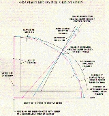
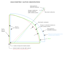
The vertical deflection (deflection of the plumb line, astro-geodetic deflection) at a point on the earth is a measure of how far the direction of the local gravity field has been shifted by local anomalies such as nearby mountains. (Here "gravity" means apparent gravity—true gravity "reduced" by the earth's spin). They are widely used in geodesy
, for surveying
networks and for geophysical purposes.
"Has been shifted"... shifted from what? Suppose the earth were perfectly spherical and homogenous, and stationary in space (not spinning). A plumb bob would always point to the center of the earth. Now say the same homogenous earth starts spinning; the plumb bob no longer points to the center of the earth (except at the pole and the equator). But it does always line up with a point on the earth's axis, the same point for a plumb bob anywhere on that parallel of latitude. The vertical deflection is everywhere zero, and the "sea level" surface is a slightly-squashed sphere with no lumps—its curvature at any point is given by the formulas for an ellipse.
In reality the sea level surface is lumpy; surveyors and mapmakers try to approximate it with an ellipsoid, and also try to measure how good the approximation is—they want to know how far sea level is above or below the ellipsoid they've chosen, and how unparallel it is. The former is geoid
height and the latter is vertical deflection.
The vertical deflection (abbrev. VD or ξ,η) is the local difference between the true zenith
(plumb line) and the line that would be perpendicular to the surface of the reference ellipsoid
chosen to approximate the earth's sea-level surface. VDs are caused by mountain
s and by geological
irregularities of the subsurface, and amount to angles of 10″ (flat areas) or 20-50″ (alpine terrain
). At the axis of valley
s the values are rather small, whereas the maxima occur at steep mountain slope
s.
The deflection of the vertical is a difference vector and therefore has two components: a north-south component ξ and an east-west component η. The value of ξ is the difference between astronomic and geodetic latitude
; the latter is usually calculated by geodetic network coordinates. The value of η is the difference between the corresponding longitude
s.
, and also with gravity anomalies
, for they are functionals of the gravity field and its inhomogeneities.
VDs are usually determined astronomically. The true zenith is observed astronomically with respect to the star
s, and the ellipsoidal zenith (theoretical vertical) by geodetic network computation, which always takes place on a reference ellipsoid
. Additionally, the very local variations of the VD can be computed from gravimetric survey data and by means of digital terrain models (DTM), using a theory originally developed by Vening-Meinesz
.
VDs are used in astro-geodetic levelling, a geoid determination technique. As a vertical deflection describes the difference between the geoidal and ellipsoidal normals, it represents the horizontal gradient
of the undulations of the geoid (i.e., the separation between geoid and reference ellipsoid). Given a starting value for the geoid undulation at one point, determining geoid undulations for an area becomes a matter for simple integration.
In practice, the deflections are observed at special points with spacings of 20 or 50 kilometers. The densification is done by a combination of DTM models and areal gravimetry
. Precise VD observations have accuracies of ±0.2″ (on high mountains ±0.5″), calculated values of about 1–2″.
The maximal VD of Central Europe
seems to be a point near the Großglockner
(3,798 m), the highest peak of the Austria
n Alps
. The approx. values are ξ = +50″ and η = −30″. In the Himalaya region, very asymmetric peaks may have VDs up to 100″ (0.03°). In the rather flat area between Vienna
and Hungary
the values are less than 15", but scatter by ±10″ for irregular rock densities in the subsurface.
105.5 km away on the other side of the island, at the lat-lon for the Keahole Pt lighthouse, Xi comes out -12.42 and Eta is -63.47: the plumb bob is deflected 65 seconds in azimuth 79 degrees.
88 km southeast of there at another survey station Xi is -56.68 and Eta is +32.89, so the plumb bob is deflected 65.5 sec in azimuth 330 degrees.
So anyone trying to determine the "actual" latitude and longitude in Hawaii in, say, 1950 would have a tough time. When they surveyed those three points they got their positions relative to each other reasonably accurately, but the latitude was 11 seconds more than NAD83 and the longitude was 10 seconds more. (The NGS data sheets give the old lat-lon (labelled "OLD HI") as well as the current NAD83.)
Few places have 4000-meter mountains 50 km from deep ocean. But any large mountain range will pull a plumb bob 10-20 arc seconds toward it, or more; determining the overall shape of the Earth was no simple matter in the days before artificial satellites.
Geodesy
Geodesy , also named geodetics, a branch of earth sciences, is the scientific discipline that deals with the measurement and representation of the Earth, including its gravitational field, in a three-dimensional time-varying space. Geodesists also study geodynamical phenomena such as crustal...
, for surveying
Surveying
See Also: Public Land Survey SystemSurveying or land surveying is the technique, profession, and science of accurately determining the terrestrial or three-dimensional position of points and the distances and angles between them...
networks and for geophysical purposes.
"Has been shifted"... shifted from what? Suppose the earth were perfectly spherical and homogenous, and stationary in space (not spinning). A plumb bob would always point to the center of the earth. Now say the same homogenous earth starts spinning; the plumb bob no longer points to the center of the earth (except at the pole and the equator). But it does always line up with a point on the earth's axis, the same point for a plumb bob anywhere on that parallel of latitude. The vertical deflection is everywhere zero, and the "sea level" surface is a slightly-squashed sphere with no lumps—its curvature at any point is given by the formulas for an ellipse.
In reality the sea level surface is lumpy; surveyors and mapmakers try to approximate it with an ellipsoid, and also try to measure how good the approximation is—they want to know how far sea level is above or below the ellipsoid they've chosen, and how unparallel it is. The former is geoid
Geoid
The geoid is that equipotential surface which would coincide exactly with the mean ocean surface of the Earth, if the oceans were in equilibrium, at rest , and extended through the continents . According to C.F...
height and the latter is vertical deflection.
The vertical deflection (abbrev. VD or ξ,η) is the local difference between the true zenith
Zenith
The zenith is an imaginary point directly "above" a particular location, on the imaginary celestial sphere. "Above" means in the vertical direction opposite to the apparent gravitational force at that location. The opposite direction, i.e...
(plumb line) and the line that would be perpendicular to the surface of the reference ellipsoid
Reference ellipsoid
In geodesy, a reference ellipsoid is a mathematically-defined surface that approximates the geoid, the truer figure of the Earth, or other planetary body....
chosen to approximate the earth's sea-level surface. VDs are caused by mountain
Mountain
Image:Himalaya_annotated.jpg|thumb|right|The Himalayan mountain range with Mount Everestrect 58 14 160 49 Chomo Lonzorect 200 28 335 52 Makalurect 378 24 566 45 Mount Everestrect 188 581 920 656 Tibetan Plateaurect 250 406 340 427 Rong River...
s and by geological
Geology
Geology is the science comprising the study of solid Earth, the rocks of which it is composed, and the processes by which it evolves. Geology gives insight into the history of the Earth, as it provides the primary evidence for plate tectonics, the evolutionary history of life, and past climates...
irregularities of the subsurface, and amount to angles of 10″ (flat areas) or 20-50″ (alpine terrain
Terrain
Terrain, or land relief, is the vertical and horizontal dimension of land surface. When relief is described underwater, the term bathymetry is used...
). At the axis of valley
Valley
In geology, a valley or dale is a depression with predominant extent in one direction. A very deep river valley may be called a canyon or gorge.The terms U-shaped and V-shaped are descriptive terms of geography to characterize the form of valleys...
s the values are rather small, whereas the maxima occur at steep mountain slope
Slope
In mathematics, the slope or gradient of a line describes its steepness, incline, or grade. A higher slope value indicates a steeper incline....
s.
The deflection of the vertical is a difference vector and therefore has two components: a north-south component ξ and an east-west component η. The value of ξ is the difference between astronomic and geodetic latitude
Latitude
In geography, the latitude of a location on the Earth is the angular distance of that location south or north of the Equator. The latitude is an angle, and is usually measured in degrees . The equator has a latitude of 0°, the North pole has a latitude of 90° north , and the South pole has a...
; the latter is usually calculated by geodetic network coordinates. The value of η is the difference between the corresponding longitude
Longitude
Longitude is a geographic coordinate that specifies the east-west position of a point on the Earth's surface. It is an angular measurement, usually expressed in degrees, minutes and seconds, and denoted by the Greek letter lambda ....
s.
Determination of vertical deflections
The deflections are connected with the local and regional undulation of the geoidUndulation of the geoid
Undulation of the geoid is the mathematical process of determining the height in meters above the geoid from the height provided by the GPS system which uses the ellipsoid as reference...
, and also with gravity anomalies
Gravity anomaly
A gravity anomaly is the difference between the observed acceleration of Earth's gravity and a value predicted from a model.-Geodesy and geophysics:...
, for they are functionals of the gravity field and its inhomogeneities.
VDs are usually determined astronomically. The true zenith is observed astronomically with respect to the star
Star
A star is a massive, luminous sphere of plasma held together by gravity. At the end of its lifetime, a star can also contain a proportion of degenerate matter. The nearest star to Earth is the Sun, which is the source of most of the energy on Earth...
s, and the ellipsoidal zenith (theoretical vertical) by geodetic network computation, which always takes place on a reference ellipsoid
Reference ellipsoid
In geodesy, a reference ellipsoid is a mathematically-defined surface that approximates the geoid, the truer figure of the Earth, or other planetary body....
. Additionally, the very local variations of the VD can be computed from gravimetric survey data and by means of digital terrain models (DTM), using a theory originally developed by Vening-Meinesz
Felix Andries Vening Meinesz
Felix Andries Vening Meinesz was a Dutch geophysicist and geodesist. He is known for his invention of a precise method for measuring gravity. Thanks to his invention, it became possible to measure gravity at sea, which led him to the discovery of gravity anomalies above the ocean floor...
.
VDs are used in astro-geodetic levelling, a geoid determination technique. As a vertical deflection describes the difference between the geoidal and ellipsoidal normals, it represents the horizontal gradient
Gradient
In vector calculus, the gradient of a scalar field is a vector field that points in the direction of the greatest rate of increase of the scalar field, and whose magnitude is the greatest rate of change....
of the undulations of the geoid (i.e., the separation between geoid and reference ellipsoid). Given a starting value for the geoid undulation at one point, determining geoid undulations for an area becomes a matter for simple integration.
In practice, the deflections are observed at special points with spacings of 20 or 50 kilometers. The densification is done by a combination of DTM models and areal gravimetry
Gravimetry
Gravimetry is the measurement of the strength of a gravitational field. Gravimetry may be used when either the magnitude of gravitational field or the properties of matter responsible for its creation are of interest...
. Precise VD observations have accuracies of ±0.2″ (on high mountains ±0.5″), calculated values of about 1–2″.
The maximal VD of Central Europe
Central Europe
Central Europe or alternatively Middle Europe is a region of the European continent lying between the variously defined areas of Eastern and Western Europe...
seems to be a point near the Großglockner
Großglockner
The Grossglockner is, at 3,798 m above sea level, Austria's highest mountain and the highest mountain in the Alps east of the Brenner Pass...
(3,798 m), the highest peak of the Austria
Austria
Austria , officially the Republic of Austria , is a landlocked country of roughly 8.4 million people in Central Europe. It is bordered by the Czech Republic and Germany to the north, Slovakia and Hungary to the east, Slovenia and Italy to the south, and Switzerland and Liechtenstein to the...
n Alps
Alps
The Alps is one of the great mountain range systems of Europe, stretching from Austria and Slovenia in the east through Italy, Switzerland, Liechtenstein and Germany to France in the west....
. The approx. values are ξ = +50″ and η = −30″. In the Himalaya region, very asymmetric peaks may have VDs up to 100″ (0.03°). In the rather flat area between Vienna
Vienna
Vienna is the capital and largest city of the Republic of Austria and one of the nine states of Austria. Vienna is Austria's primary city, with a population of about 1.723 million , and is by far the largest city in Austria, as well as its cultural, economic, and political centre...
and Hungary
Hungary
Hungary , officially the Republic of Hungary , is a landlocked country in Central Europe. It is situated in the Carpathian Basin and is bordered by Slovakia to the north, Ukraine and Romania to the east, Serbia and Croatia to the south, Slovenia to the southwest and Austria to the west. The...
the values are less than 15", but scatter by ±10″ for irregular rock densities in the subsurface.
Application of deflection data
Vertical deflections are principally used in a threefold matter:- For precise calculation of survey networks. The geodetic theodoliteTheodoliteA theodolite is a precision instrument for measuring angles in the horizontal and vertical planes. Theodolites are mainly used for surveying applications, and have been adapted for specialized purposes in fields like metrology and rocket launch technology...
s and levelling instrumentMeasuring instrumentIn the physical sciences, quality assurance, and engineering, measurement is the activity of obtaining and comparing physical quantities of real-world objects and events. Established standard objects and events are used as units, and the process of measurement gives a number relating the item...
s are oriented with respect to the true verticalVertical directionIn astronomy, geography, geometry and related sciences and contexts, a direction passing by a given point is said to be vertical if it is locally aligned with the gradient of the gravity field, i.e., with the direction of the gravitational force at that point...
, but its deflectionDeflection (physics)In physics deflection is the event where an object collides and bounces against a plane surface.In such collisions involving a sphere and a plane, the collision angle formed with the surface normal must equal the bounce angle , \alpha = \beta.Magnetic deflection refers to Lorentz forces acting...
exceeds the geodetic measuring accuracy by a factor of 5 to 50. Therefore the data have to be corrected exactly with respect to the global ellipsoid. Without these reductions, the surveys may be distortedDistortionA distortion is the alteration of the original shape of an object, image, sound, waveform or other form of information or representation. Distortion is usually unwanted, and often many methods are employed to minimize it in practice...
by some centimeters or even decimeters per km. - For the geoid determination (mean sea level) and for exact transformation of elevationElevationThe elevation of a geographic location is its height above a fixed reference point, most commonly a reference geoid, a mathematical model of the Earth's sea level as an equipotential gravitational surface ....
s. The global geoidal undulationUndulationUndulation may refer to:* Lateral undulation, the most primitive of vertebrate locomotor patterns* Law of Undulation, an invention of C. S. Lewis* Undulation of the geoid, the separation between the geoid and the reference ellipsoid of the Earth...
s amount to 50–100 m, and their regionRegionRegion is most commonly found as a term used in terrestrial and astrophysics sciences also an area, notably among the different sub-disciplines of geography, studied by regional geographers. Regions consist of subregions that contain clusters of like areas that are distinctive by their uniformity...
al values to 10–50 m. They are adequate to the integralIntegralIntegration is an important concept in mathematics and, together with its inverse, differentiation, is one of the two main operations in calculus...
s of VD components ξ,η and therefore can be calculated with cm accuracy over distances of many kilometers. - For GPS surveys. The satelliteSatelliteIn the context of spaceflight, a satellite is an object which has been placed into orbit by human endeavour. Such objects are sometimes called artificial satellites to distinguish them from natural satellites such as the Moon....
s measurements refer to a pure geometricalGeometryGeometry arose as the field of knowledge dealing with spatial relationships. Geometry was one of the two fields of pre-modern mathematics, the other being the study of numbers ....
system (usually the WGS84 ellipsoid), whereas the terrestrial heights refer to the geoid. We need accurate geoid data to combine the different types of measurements. - For geophysicsGeophysicsGeophysics is the physics of the Earth and its environment in space; also the study of the Earth using quantitative physical methods. The term geophysics sometimes refers only to the geological applications: Earth's shape; its gravitational and magnetic fields; its internal structure and...
. Because VD deflection data are affected by the physical structure of the Earth's crustCrust (geology)In geology, the crust is the outermost solid shell of a rocky planet or natural satellite, which is chemically distinct from the underlying mantle...
and mantle, geodesists are engaged in models to improve our knowledge of the Earth's interior. Additionally and similar to applied geophysics, the VD data can support the future explorationExplorationExploration is the act of searching or traveling around a terrain for the purpose of discovery of resources or information. Exploration occurs in all non-sessile animal species, including humans...
of raw materials, oilPetroleumPetroleum or crude oil is a naturally occurring, flammable liquid consisting of a complex mixture of hydrocarbons of various molecular weights and other liquid organic compounds, that are found in geologic formations beneath the Earth's surface. Petroleum is recovered mostly through oil drilling...
, gas or oreOreAn ore is a type of rock that contains minerals with important elements including metals. The ores are extracted through mining; these are then refined to extract the valuable element....
s.
Example: Hawaii
On their website NGS gives the NAD83 latitude and longitude for the water tank north of the airport at Hilo, on the big island of Hawaii. We can plug that lat-lon into another part of the website and learn Xi is +12.67 seconds and Eta is +48.32 sec. So a plumb bob is deflected 50 sec in azimuth 255 degrees.105.5 km away on the other side of the island, at the lat-lon for the Keahole Pt lighthouse, Xi comes out -12.42 and Eta is -63.47: the plumb bob is deflected 65 seconds in azimuth 79 degrees.
88 km southeast of there at another survey station Xi is -56.68 and Eta is +32.89, so the plumb bob is deflected 65.5 sec in azimuth 330 degrees.
So anyone trying to determine the "actual" latitude and longitude in Hawaii in, say, 1950 would have a tough time. When they surveyed those three points they got their positions relative to each other reasonably accurately, but the latitude was 11 seconds more than NAD83 and the longitude was 10 seconds more. (The NGS data sheets give the old lat-lon (labelled "OLD HI") as well as the current NAD83.)
Few places have 4000-meter mountains 50 km from deep ocean. But any large mountain range will pull a plumb bob 10-20 arc seconds toward it, or more; determining the overall shape of the Earth was no simple matter in the days before artificial satellites.
See also
- Vertical directionVertical directionIn astronomy, geography, geometry and related sciences and contexts, a direction passing by a given point is said to be vertical if it is locally aligned with the gradient of the gravity field, i.e., with the direction of the gravitational force at that point...
- ZenithZenithThe zenith is an imaginary point directly "above" a particular location, on the imaginary celestial sphere. "Above" means in the vertical direction opposite to the apparent gravitational force at that location. The opposite direction, i.e...
- Gravity anomalyGravity anomalyA gravity anomaly is the difference between the observed acceleration of Earth's gravity and a value predicted from a model.-Geodesy and geophysics:...