
Utah State Route 128
Encyclopedia
State Route 128 is a state highway
in the U.S. state of Utah
. The entire length of the highway has been designated the Upper Colorado River Scenic Byway, as part of the Utah Scenic Byways
program. This road also forms part of the Dinosaur Diamond Prehistoric Highway, a National Scenic Byway
. Residents of Moab
frequently refer to SR-128 as "the river road", after the Colorado River
, which the highway follows.
The highway was originally constructed to connect rural cities in eastern Utah with Grand Junction, Colorado
, the largest city in the region. Part of the highway was merged into the Utah state highway system in 1931; the rest was taken over by the state and assigned route number 128 in 1933. Today, the highway is used as a scenic drive for visitors to the area.
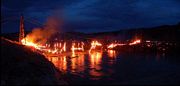
The highway crosses the Colorado River at the site of the Dewey Bridge, listed on the National Register of Historic Places
. This bridge was the longest suspension bridge in Utah until April 2008 when it was destroyed by a fire started by a child playing with matches. The future of the bridge is uncertain, with Grand County conducting a study to determine the feasibility of reconstructing it.
 State Route 128 begins just north of Moab
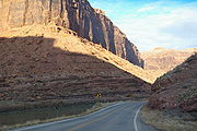
, where it is commonly known as "the river road". The highway follows the southern bank of the Colorado River
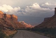
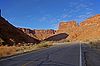
through a narrow, steep gorge, described as spectacular by National Geographic. The sheer sandstone
walls of the gorge along Route 128 are recommended for their beauty on vacation guides from as far away as France and Germany.
As parts of the road are very narrow, with blind corners and no shoulders
, the Utah Department of Transportation
has prohibited trucks and vehicles over 55000 pounds (24,948 kg) from the entire highway. In addition, a restriction at the junction with U.S. Route 191 requires vehicles over 15 feet (4.6 m) wide to have two police escorts.
Between Moab and Castle Valley
, the Colorado River, and indirectly, Route 128, form the southern boundary of Arches National Park
. Arches National Park is so named because of over 2000 natural arch
es inside park boundaries. While the highway does offer views of several features in the park, there is no park access along the highway. Popular attractions along this portion include Negro Bill Canyon
, with hiking trails to Morning Glory Arch, campgrounds and boat docks at a curve in the river called Big Bend.
 The gorge widens where the highway passes by Castle Valley and Professor Valley, which have been the shooting locations for many western films (including Wagon Master
and Rio Grande
) and television commercials. Near the east end of the valley the highway crosses Onion Creek, a steam sourced by springs that contain naturally occurring minerals that produce a strong odor in the water. At the east end of the valley the highway has a view of the Fisher Towers, a set of dark red spire
s. After leaving the valley, the road winds farther up the river gorge until arriving at the Dewey Bridge, named for Dewey
, a nearby ghost town
.
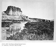
After the bridge, the road follows the northern bank of the river for a few miles then exits the Colorado River gorge. At this point the highway proceeds across desert towards the Book Cliffs
to terminate at Interstate 70 near Cisco
. Cisco is a ghost town along the main line of the Denver and Rio Grande Western Railroad
, founded as a water re-filling station for steam locomotive
s. The last 3 miles (4.8 km) of the road parallel the railroad and is an old routing of U.S. Route 6/U.S. Route 50, in use before the construction of I-70.
 Access between Moab and Castle Valley was originally via a pack trail called the Heavenly Stairway. This trail, named for a dramatic descent of over 1000 feet (304.8 m), was described as beautiful, but difficult to navigate. Isolated from Utah's population centers, this area depended on Grand Junction
and other cities in Colorado for both everyday supplies and a market for agricultural products. Moab residents pushed for a road to be built along the riverbank. By 1902, the trail was replaced with a toll road, called King's Toll Road, after Samuel King. King was an early settler who also operated the toll ferry
used prior to the construction of the Dewey Bridge. Rocks inscribed with "Kings Toll Road" can still be found along the roadway. While the road did improve travel, it was not built high enough above the river level and was often flooded.
 In 1912 Grand County
unsuccessfully petitioned the state to finance the construction of a bridge. In 1913, the ferry was out of service for a time because ice in the river struck the ferry, causing it to sink. This raised the level of urgency for a more reliable river crossing. Grand County held a municipal bond
election, and was able to raise $25,000 (1913, approximately equivalent to $550,000 in 2008) to finance the construction of a bridge. The county employed the Midland Bridge Company
of Kansas City, Missouri
, to build it. Plans originally called for the bridge deck to be 12 feet (3.7 m) wide, but with the bonds not producing the expected yields, the deck width was scaled down to 8 feet (2.4 m). In 1916, the bridge was dedicated with a strength test by having approximately 70 attendees attempt cross the bridge at once. The total was seven wagons, two people on horseback and several on foot. The bridge was designed to support the weight of six horses, three wagons, and 9000 pounds (4,082.3 kg) of freight.
On the day of its completion, it was the second-longest suspension bridge
west of the Mississippi River
. The longest was also built by the Midland Bridge Company, who used the same base plans for both bridges. The longer twin to the Dewey Bridge crossed the Little Colorado River
along U.S. Route 89 in Cameron, Arizona
. The Dewey Bridge remained the longest suspension bridge in Utah until it was destroyed by fire in 2008.
 As part of a tribute, a reporter for The Daily Sentinel interviewed locals and visitors about their first experience crossing the bridge. Many recalled how nervous they felt as the bridge would creak and sway under load. One stated, "A lot of people lost a lot of mirrors on that bridge". Drivers with wide vehicles had to fold in their side mirrors to safely cross, as the bridge deck was only 8 feet (2.4 m) wide.
An agreement was reached in 1984 between the Grand County Commission and the Utah Department of Transportation
(UDOT) to balance the conflicting public demands to retire and preserve the aging bridge. As part of this agreement, UDOT would commission a new bridge and once finished, transfer ownership of the original bridge back to Grand County. Grand County agreed to petition to have the bridge be included in the National Register of Historic Places
, assume maintenance and guarantee the bridge would be preserved. The nomination was approved and the bridge was added to the National Register of Historic Places on July 12, 1984. In 1988, the replacement bridge was completed, and the title deed to the Dewey Bridge was handed over to the county in 1989. Grand County completed a restoration project in 2000.
 After being replaced for automobile use, the Dewey Bridge was used by the Kokopelli trail
, a bicycle trail, and a pedestrian trail. The east approach to the bridge features an abandoned gas station and the ghost town
of Dewey
. The west approach has been converted to a rest area
and park.
On April 6, 2008, a seven-year-old boy accidentally started a fire in a nearby campground while playing with matches. The fire moved up the riverbank and destroyed the bridge's wooden deck and rails. The county funded a study to determine the feasibility and cost of reconstructing the bridge. The engineers determined that the steel cables and towers most likely did not suffer structural damage and could be reused. The study estimated reconstruction costs at $850,000. The engineers determined the original blueprint
s, preserved in a museum, were of sufficient quality that only minimal engineering work would be required. The county agreed to direct the effort, but will not fund it with taxpayer money. As replicas do not qualify for historical status, historians are debating if using the original towers and cable is enough for the structure to qualify as historical. Grand County has set up an account for interested parties to donate to the reconstruction effort.
Though the Colorado River runs for over 400 miles (643.7 km) in Utah, there are only three sites with bridges to cross it. One is the Dewey Bridge site where SR-128 traverses the waterway; the other two are an unnamed bridge that carries US-191 (built in 1911, replaced in 1955 and again in 2010) and the Hite Crossing Bridge
(built in 1966) used by SR-95.
 With the bridge finished in 1916, by the 1920s the toll road was reconstructed above the ordinary high water mark
so it could be used year-round. The road was briefly used for the route of the Midland Trail
across eastern Utah. However, by 1923 the trail had been moved to a more direct routing, similar to modern I-70
. The road from Moab along the river to Castleton was added to the state highway network in 1931, as SR-129. In 1933, the route was redesignated SR-128 and extended to Cisco. The highway was gradually upgraded to a two-lane paved roadway.
The state legislature extended SR-128 about 3 miles (5 km) at its east end in 1969, due to the pending construction of Interstate 70. Plans called for the freeway to bypass the Cisco area, including the terminus of SR-128. The legislature transferred a portion of SR-4 (the legislative designation for what was then signed US-6/US-50) near Cisco to the proposed junction with I-70. When that part of I-70 was completed in 1971, signs were changed to SR-128 on its portion of the old road, while the remainder of the bypassed road through Cisco was relinquished to the county.
The highway was recognized by the Utah Scenic Byways
program for its scenic value and given the name Upper Colorado River Scenic Byway. The highway was recognized as a National Scenic Byway
and named as part of the Dinosaur Diamond Scenic Byway
in 1998. A petition is currently before the Federal Highway Administration
to recognize Route 128 as an All-American Road. To meet this criterion the highway must be deemed by the administration to have enough scenic value to be a "destination unto itself".
.
State highway
State highway, state road or state route can refer to one of three related concepts, two of them related to a state or provincial government in a country that is divided into states or provinces :#A...
in the U.S. state of Utah
Utah
Utah is a state in the Western United States. It was the 45th state to join the Union, on January 4, 1896. Approximately 80% of Utah's 2,763,885 people live along the Wasatch Front, centering on Salt Lake City. This leaves vast expanses of the state nearly uninhabited, making the population the...
. The entire length of the highway has been designated the Upper Colorado River Scenic Byway, as part of the Utah Scenic Byways
Utah Scenic Byways
The legislature in the U.S. state of Utah has designated a system of Utah Scenic Byways in addition to the National Scenic Byways that are defined within the state. Some of the state designated routes overlap with the federal designations...
program. This road also forms part of the Dinosaur Diamond Prehistoric Highway, a National Scenic Byway
National Scenic Byway
A National Scenic Byway is a road recognized by the United States Department of Transportation for its archeological, cultural, historic, natural, recreational, and/or scenic qualities. The program was established by Congress in 1991 to preserve and protect the nation's scenic but often...
. Residents of Moab
Moab, Utah
Moab is a city in Grand County, in eastern Utah, in the western United States. The population was 4,779 at the 2000 census. It is the county seat and largest city in Grand County. Moab hosts a large number of tourists every year, mostly visitors to the nearby Arches and Canyonlands National Parks...
frequently refer to SR-128 as "the river road", after the Colorado River
Colorado River
The Colorado River , is a river in the Southwestern United States and northwestern Mexico, approximately long, draining a part of the arid regions on the western slope of the Rocky Mountains. The watershed of the Colorado River covers in parts of seven U.S. states and two Mexican states...
, which the highway follows.
The highway was originally constructed to connect rural cities in eastern Utah with Grand Junction, Colorado
Grand Junction, Colorado
The City of Grand Junction is the largest city in western Colorado. It is a city with a council–manager government form that is the county seat and the most populous city of Mesa County, Colorado, United States. Grand Junction is situated west-southwest of the Colorado State Capitol in Denver. As...
, the largest city in the region. Part of the highway was merged into the Utah state highway system in 1931; the rest was taken over by the state and assigned route number 128 in 1933. Today, the highway is used as a scenic drive for visitors to the area.
The highway crosses the Colorado River at the site of the Dewey Bridge, listed on the National Register of Historic Places
National Register of Historic Places
The National Register of Historic Places is the United States government's official list of districts, sites, buildings, structures, and objects deemed worthy of preservation...
. This bridge was the longest suspension bridge in Utah until April 2008 when it was destroyed by a fire started by a child playing with matches. The future of the bridge is uncertain, with Grand County conducting a study to determine the feasibility of reconstructing it.
Route description
Moab, Utah
Moab is a city in Grand County, in eastern Utah, in the western United States. The population was 4,779 at the 2000 census. It is the county seat and largest city in Grand County. Moab hosts a large number of tourists every year, mostly visitors to the nearby Arches and Canyonlands National Parks...
, where it is commonly known as "the river road". The highway follows the southern bank of the Colorado River
Colorado River
The Colorado River , is a river in the Southwestern United States and northwestern Mexico, approximately long, draining a part of the arid regions on the western slope of the Rocky Mountains. The watershed of the Colorado River covers in parts of seven U.S. states and two Mexican states...
through a narrow, steep gorge, described as spectacular by National Geographic. The sheer sandstone
Sandstone
Sandstone is a sedimentary rock composed mainly of sand-sized minerals or rock grains.Most sandstone is composed of quartz and/or feldspar because these are the most common minerals in the Earth's crust. Like sand, sandstone may be any colour, but the most common colours are tan, brown, yellow,...
walls of the gorge along Route 128 are recommended for their beauty on vacation guides from as far away as France and Germany.
As parts of the road are very narrow, with blind corners and no shoulders
Shoulder (road)
A hard shoulder, or simply shoulder, is a reserved area by the verge of a road or motorway. Generally it is kept clear of motor vehicle traffic...
, the Utah Department of Transportation
Utah Department of Transportation
The Utah Department of Transportation is an agency of the state government for the U.S. state of Utah. The agency is usually referred to by its initials UDOT . UDOT is charged with maintaining the network of state highways in Utah. The agency is headquartered in the Calvin L. Rampton state office...
has prohibited trucks and vehicles over 55000 pounds (24,948 kg) from the entire highway. In addition, a restriction at the junction with U.S. Route 191 requires vehicles over 15 feet (4.6 m) wide to have two police escorts.
Between Moab and Castle Valley
Castle Valley, Utah
Castle Valley is a town in Grand County, Utah, United States. The population was 349 at the 2000 census. The town is about 16 miles northeast of Moab near State Route 128.-Geography:Castle Valley is located at ....
, the Colorado River, and indirectly, Route 128, form the southern boundary of Arches National Park
Arches National Park
Arches National Park is a U.S. National Park in eastern Utah. It is known for preserving over 2000 natural sandstone arches, including the world-famous Delicate Arch, in addition to a variety of unique geological resources and formations....
. Arches National Park is so named because of over 2000 natural arch
Natural arch
A natural arch or natural bridge is a natural geological formation where a rock arch forms, with an opening underneath. Most natural arches form as a narrow ridge, walled by cliffs, become narrower from erosion, with a softer rock stratum under the cliff-forming stratum gradually eroding out until...
es inside park boundaries. While the highway does offer views of several features in the park, there is no park access along the highway. Popular attractions along this portion include Negro Bill Canyon
Negro Bill Canyon
Negro Bill Canyon is a canyon in southeast Utah. It is part of the Colorado River watershed. Its stream flows directly into the main channel of the Colorado River within Moab Canyon....
, with hiking trails to Morning Glory Arch, campgrounds and boat docks at a curve in the river called Big Bend.
Wagon Master
Wagon Master is a 1950 Western film directed by John Ford and starring Ben Johnson, Harry Carey Jr., Joanne Dru, and Ward Bond.-Plot:Learning of their ability as experienced horsemen, Mormon Elder Wiggs , hires Travis Blue and Sandy Owens to guide a small group of Mormons across the West to the...
and Rio Grande
Rio Grande (film)
Rio Grande is a 1950 Western film. It is the third installment of John Ford's "cavalry trilogy," following two RKO Pictures releases: Fort Apache and She Wore a Yellow Ribbon ....
) and television commercials. Near the east end of the valley the highway crosses Onion Creek, a steam sourced by springs that contain naturally occurring minerals that produce a strong odor in the water. At the east end of the valley the highway has a view of the Fisher Towers, a set of dark red spire
Spire
A spire is a tapering conical or pyramidal structure on the top of a building, particularly a church tower. Etymologically, the word is derived from the Old English word spir, meaning a sprout, shoot, or stalk of grass....
s. After leaving the valley, the road winds farther up the river gorge until arriving at the Dewey Bridge, named for Dewey
Dewey, Utah
Dewey is a ghost town in Grand County, Utah. Originally named Kingsferry, it began in the 1880s when Samuel King built and operated a ferry across the Grand River . A small community soon developed around the ferry, although it never grew large. The town served as a ferry crossing until the Dewey...
, a nearby ghost town
Ghost town
A ghost town is an abandoned town or city. A town often becomes a ghost town because the economic activity that supported it has failed, or due to natural or human-caused disasters such as floods, government actions, uncontrolled lawlessness, war, or nuclear disasters...
.
After the bridge, the road follows the northern bank of the river for a few miles then exits the Colorado River gorge. At this point the highway proceeds across desert towards the Book Cliffs
Book Cliffs
The Book Cliffs are a series of mountains and cliffs in western Colorado and eastern Utah, in the western United States. They are so named because many of them have the triangular appearance of a book that has been opened up, then turned on its sides and set to rest on the open sides of the book,...
to terminate at Interstate 70 near Cisco
Cisco, Utah
Cisco is a ghost town in Grand County, Utah near the junction of State Route 128 and Interstate 70. At one time the town served as a saloon and water-refilling station for the Denver and Rio Grande Western Railroad. The town's demise came with the demise of the steam locomotive. The town site...
. Cisco is a ghost town along the main line of the Denver and Rio Grande Western Railroad
Denver and Rio Grande Western Railroad
The Denver & Rio Grande Western Railroad , often shortened to Rio Grande or D&RGW, formerly the Denver & Rio Grande Railroad, is a defunct U.S. railroad company. The railroad started as a narrow gauge line running south from Denver, Colorado in 1870; however, served mainly as a transcontinental...
, founded as a water re-filling station for steam locomotive
Steam locomotive
A steam locomotive is a railway locomotive that produces its power through a steam engine. These locomotives are fueled by burning some combustible material, usually coal, wood or oil, to produce steam in a boiler, which drives the steam engine...
s. The last 3 miles (4.8 km) of the road parallel the railroad and is an old routing of U.S. Route 6/U.S. Route 50, in use before the construction of I-70.
History
Grand Junction, Colorado
The City of Grand Junction is the largest city in western Colorado. It is a city with a council–manager government form that is the county seat and the most populous city of Mesa County, Colorado, United States. Grand Junction is situated west-southwest of the Colorado State Capitol in Denver. As...
and other cities in Colorado for both everyday supplies and a market for agricultural products. Moab residents pushed for a road to be built along the riverbank. By 1902, the trail was replaced with a toll road, called King's Toll Road, after Samuel King. King was an early settler who also operated the toll ferry
Ferry
A ferry is a form of transportation, usually a boat, but sometimes a ship, used to carry primarily passengers, and sometimes vehicles and cargo as well, across a body of water. Most ferries operate on regular, frequent, return services...
used prior to the construction of the Dewey Bridge. Rocks inscribed with "Kings Toll Road" can still be found along the roadway. While the road did improve travel, it was not built high enough above the river level and was often flooded.
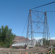
Dewey Bridge
The Dewey Bridge, built in 1916, originally carried SR-128 across the Colorado River. The bridge featured an all wood deck measuring 502 feet (153 m) long, 10.2 feet (3.1 m) wide from support to support and 8 feet (2.4 m) wide from rail to rail. The bridge also consisted of two metal towers, a run of seven cables on each side of the bridge deck, and cable anchors.Grand County, Utah
Grand County is a county located in the U.S. state of Utah. As of 2000 the population was 8,485, and by 2005 had been estimated at 8,743. It was named for the Colorado River, which at the time of statehood was known as the Grand River. Its county seat and largest city is Moab.-Geography:According...
unsuccessfully petitioned the state to finance the construction of a bridge. In 1913, the ferry was out of service for a time because ice in the river struck the ferry, causing it to sink. This raised the level of urgency for a more reliable river crossing. Grand County held a municipal bond
Municipal bond
A municipal bond is a bond issued by a city or other local government, or their agencies. Potential issuers of municipal bonds includes cities, counties, redevelopment agencies, special-purpose districts, school districts, public utility districts, publicly owned airports and seaports, and any...
election, and was able to raise $25,000 (1913, approximately equivalent to $550,000 in 2008) to finance the construction of a bridge. The county employed the Midland Bridge Company
Midland Bridge Company
The Midland Bridge Company is a firm based in Kansas City, Missouri that has built numerous bridges. Several of its works are listed on the U.S. National Register of Historic Places .Works of the firm include:...
of Kansas City, Missouri
Kansas City, Missouri
Kansas City, Missouri is the largest city in the U.S. state of Missouri and is the anchor city of the Kansas City Metropolitan Area, the second largest metropolitan area in Missouri. It encompasses in parts of Jackson, Clay, Cass, and Platte counties...
, to build it. Plans originally called for the bridge deck to be 12 feet (3.7 m) wide, but with the bonds not producing the expected yields, the deck width was scaled down to 8 feet (2.4 m). In 1916, the bridge was dedicated with a strength test by having approximately 70 attendees attempt cross the bridge at once. The total was seven wagons, two people on horseback and several on foot. The bridge was designed to support the weight of six horses, three wagons, and 9000 pounds (4,082.3 kg) of freight.
On the day of its completion, it was the second-longest suspension bridge
Suspension bridge
A suspension bridge is a type of bridge in which the deck is hung below suspension cables on vertical suspenders. Outside Tibet and Bhutan, where the first examples of this type of bridge were built in the 15th century, this type of bridge dates from the early 19th century...
west of the Mississippi River
Mississippi River
The Mississippi River is the largest river system in North America. Flowing entirely in the United States, this river rises in western Minnesota and meanders slowly southwards for to the Mississippi River Delta at the Gulf of Mexico. With its many tributaries, the Mississippi's watershed drains...
. The longest was also built by the Midland Bridge Company, who used the same base plans for both bridges. The longer twin to the Dewey Bridge crossed the Little Colorado River
Little Colorado River
The Little Colorado River is a river in the U.S. state of Arizona, providing the principal drainage from the Painted Desert region. Together with its major tributary, the Puerco River, it drains an area of about in eastern Arizona and western New Mexico...
along U.S. Route 89 in Cameron, Arizona
Cameron, Arizona
Cameron is a census-designated place in Coconino County, Arizona, United States. The population was 978 at the 2000 census. Most of the town's economy is tourist food and craft stalls, restaurants, and other services for north-south traffic from Flagstaff and Page...
. The Dewey Bridge remained the longest suspension bridge in Utah until it was destroyed by fire in 2008.
An agreement was reached in 1984 between the Grand County Commission and the Utah Department of Transportation
Utah Department of Transportation
The Utah Department of Transportation is an agency of the state government for the U.S. state of Utah. The agency is usually referred to by its initials UDOT . UDOT is charged with maintaining the network of state highways in Utah. The agency is headquartered in the Calvin L. Rampton state office...
(UDOT) to balance the conflicting public demands to retire and preserve the aging bridge. As part of this agreement, UDOT would commission a new bridge and once finished, transfer ownership of the original bridge back to Grand County. Grand County agreed to petition to have the bridge be included in the National Register of Historic Places
National Register of Historic Places
The National Register of Historic Places is the United States government's official list of districts, sites, buildings, structures, and objects deemed worthy of preservation...
, assume maintenance and guarantee the bridge would be preserved. The nomination was approved and the bridge was added to the National Register of Historic Places on July 12, 1984. In 1988, the replacement bridge was completed, and the title deed to the Dewey Bridge was handed over to the county in 1989. Grand County completed a restoration project in 2000.
Kokopelli Trail
Kokopelli's Trail is a 142 mile multi-use trail in the U.S. states of Colorado and Utah. The trail was named in honor of its mythic muse, Kokopelli...
, a bicycle trail, and a pedestrian trail. The east approach to the bridge features an abandoned gas station and the ghost town
Ghost town
A ghost town is an abandoned town or city. A town often becomes a ghost town because the economic activity that supported it has failed, or due to natural or human-caused disasters such as floods, government actions, uncontrolled lawlessness, war, or nuclear disasters...
of Dewey
Dewey, Utah
Dewey is a ghost town in Grand County, Utah. Originally named Kingsferry, it began in the 1880s when Samuel King built and operated a ferry across the Grand River . A small community soon developed around the ferry, although it never grew large. The town served as a ferry crossing until the Dewey...
. The west approach has been converted to a rest area
Rest area
A rest area, travel plaza, rest stop, or service area is a public facility, located next to a large thoroughfare such as a highway, expressway, or freeway at which drivers and passengers can rest, eat, or refuel without exiting on to secondary roads...
and park.
On April 6, 2008, a seven-year-old boy accidentally started a fire in a nearby campground while playing with matches. The fire moved up the riverbank and destroyed the bridge's wooden deck and rails. The county funded a study to determine the feasibility and cost of reconstructing the bridge. The engineers determined that the steel cables and towers most likely did not suffer structural damage and could be reused. The study estimated reconstruction costs at $850,000. The engineers determined the original blueprint
Blueprint
A blueprint is a type of paper-based reproduction usually of a technical drawing, documenting an architecture or an engineering design. More generally, the term "blueprint" has come to be used to refer to any detailed plan....
s, preserved in a museum, were of sufficient quality that only minimal engineering work would be required. The county agreed to direct the effort, but will not fund it with taxpayer money. As replicas do not qualify for historical status, historians are debating if using the original towers and cable is enough for the structure to qualify as historical. Grand County has set up an account for interested parties to donate to the reconstruction effort.
Though the Colorado River runs for over 400 miles (643.7 km) in Utah, there are only three sites with bridges to cross it. One is the Dewey Bridge site where SR-128 traverses the waterway; the other two are an unnamed bridge that carries US-191 (built in 1911, replaced in 1955 and again in 2010) and the Hite Crossing Bridge
Hite Crossing Bridge
The Hite Crossing Bridge is an arch bridge which carries Utah State Route 95 across the Colorado River northwest of Blanding, Utah, United States. The bridge informally marks the upstream limit of Lake Powell and the end of Cataract Canyon of the Colorado River, but when the lake is at normal...
(built in 1966) used by SR-95.
From trail to highway
Ordinary high water mark
Ordinary high water mark refers to the highest level reached by a body of water that has been maintained for a sufficient period of time to leave evidence on the landscape. It may be indicated by destruction of terrestrial vegetation, the presence of marks on trees or debris deposits...
so it could be used year-round. The road was briefly used for the route of the Midland Trail
Midland Trail
For the trail's section in West Virginia see: The Midland Trail in West Virginia.The Midland Trail, also called the Roosevelt Midland Trail, was a national auto trail spanning the United States from Washington, D.C...
across eastern Utah. However, by 1923 the trail had been moved to a more direct routing, similar to modern I-70
Interstate 70 in Utah
Interstate 70 is a mainline route of the Interstate Highway System in the United States connecting Utah and Maryland. The Utah section runs east–west for across the central part of the state. Richfield is the largest Utah city served by the freeway, which does not serve or connect any urban areas...
. The road from Moab along the river to Castleton was added to the state highway network in 1931, as SR-129. In 1933, the route was redesignated SR-128 and extended to Cisco. The highway was gradually upgraded to a two-lane paved roadway.
The state legislature extended SR-128 about 3 miles (5 km) at its east end in 1969, due to the pending construction of Interstate 70. Plans called for the freeway to bypass the Cisco area, including the terminus of SR-128. The legislature transferred a portion of SR-4 (the legislative designation for what was then signed US-6/US-50) near Cisco to the proposed junction with I-70. When that part of I-70 was completed in 1971, signs were changed to SR-128 on its portion of the old road, while the remainder of the bypassed road through Cisco was relinquished to the county.
The highway was recognized by the Utah Scenic Byways
Utah Scenic Byways
The legislature in the U.S. state of Utah has designated a system of Utah Scenic Byways in addition to the National Scenic Byways that are defined within the state. Some of the state designated routes overlap with the federal designations...
program for its scenic value and given the name Upper Colorado River Scenic Byway. The highway was recognized as a National Scenic Byway
National Scenic Byway
A National Scenic Byway is a road recognized by the United States Department of Transportation for its archeological, cultural, historic, natural, recreational, and/or scenic qualities. The program was established by Congress in 1991 to preserve and protect the nation's scenic but often...
and named as part of the Dinosaur Diamond Scenic Byway
Dinosaur Diamond Scenic Byway
The Dinosaur Diamond Scenic Byway is a 512-mile National Scenic Byway in the U.S. states of Utah and Colorado. The highway forms a diamond-shaped loop with vertices at Moab, Helper, Vernal and Grand Junction....
in 1998. A petition is currently before the Federal Highway Administration
Federal Highway Administration
The Federal Highway Administration is a division of the United States Department of Transportation that specializes in highway transportation. The agency's major activities are grouped into two "programs," the Federal-aid Highway Program and the Federal Lands Highway Program...
to recognize Route 128 as an All-American Road. To meet this criterion the highway must be deemed by the administration to have enough scenic value to be a "destination unto itself".
Major intersections
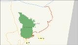
The entire route is located within Grand CountyGrand County, Utah
Grand County is a county located in the U.S. state of Utah. As of 2000 the population was 8,485, and by 2005 had been estimated at 8,743. It was named for the Colorado River, which at the time of statehood was known as the Grand River. Its county seat and largest city is Moab.-Geography:According...
.
See also
- Dewey Bridge Member – a type of Entrada Sandstone named for the Dewey Bridge
- State Route 279Utah State Route 279State Route 279 is a state highway in the U.S. state of Utah. The highway was constructed in 1962–1963 to service the Cane Creek potash mine and processing plant southwest of Moab. The highway was named one of the most beautiful highways opened to traffic in 1963...
– Lower Colorado River Scenic Byway
External links
- SR-128 (photo guide) by Lalas Reisen (German)
- Photo Gallery – Dewey Bridge by Dave Beeden
- Pictures of the Dewey Bridge burning by Skez