

Upper James Street (Hamilton, Ontario)
Encyclopedia
Upper James Street, is an Upper City (mountain) arterial road in Hamilton, Ontario
, Canada
. It starts at the Claremont Access, a mountain-access road in the north, and extends southward towards the John C. Munro Hamilton International Airport where it then changes its name to the Hamilton Port Dover Plain Road, (Highway 6
). It is a two-way street throughout.
(Note: Highway 6 now uses a new alignment from Highway 403
to south of the Hamilton Airport, connecting with the southerly leg to Caledonia
, the Grand River
and Port Dover
.)
in the Lower City Hamilton and was named after one of Nathaniel Hughson
's sons. Hughson was one of the City founders along with George Hamilton
and James Durand
. Originally it was called the Caledonia Road because it was the road that lead to Caledonia, Ontario
.
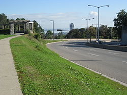
As early as 1842 an inn was situated at the top of the escarpment near Claremont access, where present day Southam Park is situated. By 1850 a four-storey stone structure was erected at the site and it was called the Mountain View Hotel. It met the needs of those travelling the Caledonia Road, (Upper James Street). Farmers travelling in from townships south of Hamilton rested their horses here on the way to and from the Hamilton Farmer's Market
. It offered patrons an unobstructed view of the city below and Lake Ontario beyond. The hotel served as a lookout point for Thirteenth Battalion during the Fenian threat
in 1866. The building was destroyed by fire in 1878 and replaced by a new five-storey structure that included an elaborate observation tower on its eastern end in 1881. In 1890 a pavilion suitable for roller skating
and dancing was added attracting various family and organized events. Access was improved with an Incline railway immediately to the north. When the establishments liquor license
was revoked in 1916 the property was sold. It then served as the home for the Hamilton Hunt Club. The building was razed in 1937 and the grounds were donated to the City of Hamilton for use as a park in 1943.
 James Street
, at the base of the Niagara Escarpment
was the site of the city's first Incline railway (1892–1932). Back then, the incline railway on James Street was known as the Hamilton & Barton Incline Railway. It connected up to present day Upper James Street. The city's second Incline railway on Wentworth Street South
, (1895-1936), was known as the Eastend Incline Railway but was often called, The Mount Hamilton Incline Railway. The Eastend Incline on Wentworth Street was electrically operated and the Westend Incline on James Street depended on steam for its power.
In 1924, following the city's booming development in the east, there was some serious discussion regarding the addition of a third incline railway. The two locations considered at the time were Sherman Avenue
or Ottawa Street South
. The population of Hamilton Mountain at the time was 6,000.
In 1929, the city's brochures were using the motto, "The City Beautiful and Hub of Canadian Highways" as well as "The City of Opportunity". In regards to the incline railways, the brochures go on to boast, "There is no finer view anywhere on the North American continent than the panorama to be seen from the Hamilton mountain. The city below, the blue waters of Hamilton harbour and Lake Ontario
. In the background, flanked on the east by the famous Niagara Fruit District and on the west by the beautiful Dundas Valley and a range of hills, combine to make a picture no artist could paint. There are several roads leading up to the summit and you can drive upon "high", but if you want to enjoy a unique experience and give the family a thrill, drive your car onto one of the Incline Railways and you will have something to tell the folks about when you go back home."
Construction began on November 1890 with the clearing of the right of way between James Street South and the Caledonia Road near the site of the Mountain View Hotel. The double tracks were 700 feet in length on a grade of 31% to overcome the 195-foot rise of the escarpment. Over half the line was supported on trestles
which, at their maximum, held the 36-foot-long cars 50 feet above the ground. Stationary engines drew the cars to the top using steel cables.
Opened June 11, 1892, it was heavily used by residents and tourists alike. The 75-second
ride provided a convenient link between the city and Barton Township for both pedestrian and horse-drawn traffic. Improved mountain access roads and the rise in popularity of motorized traffic caused a steadily declining numbers of customers. The line ceased operation on December 26, 1931.
The abandoned rails and equipment were removed during World War II
and the right of way came under the jurisdiction of the Hamilton Parks Board.
and is named for John C. Munro, a Hamilton Member of Parliament
and cabinet minister. John Munro, elected to the Canadian House of Commons
in the 1962 election, and served continuously as a Member of Parliament (MP) for Hamilton, Ontario. Munro was appointed to Cabinet by Prime Minister Pierre Trudeau
, and served variously as Minister of Amateur Sport, Minister of Health and Welfare and Minister of Labour from 1968 to 1978 when he was forced to resign from over the "Skyshops" scandal. The airport was originally built in 1940 as the Mount Hope Airport, a Royal Canadian Air Force
base. After the war
, the airport gradually shifted towards civil use, The military ceased using it as a base in 1964. In 1994 Transport Canada
announces it will divest itself of local and regional airports. The region of Hamilton issues a request for proposals from private firms to run the airport. In 1996 Hamilton International Airport Limited (HIAL) is the fully owned subsidiary of TradePort International Corporation. HIAL begins to manage the Hamilton/John C. Munro International Airport. TradePort, winner of the bid to take over the airport, assumes responsibility to manage, finance and operate it under a 40-year lease.
The Canadian Warplane Heritage Museum
is a major Canadian
aviation museum. It is located at the John C. Munro International Airport. The museum is a non-profit organization whose mandate is to acquire, document, preserve and maintain a complete collection of aircraft that were flown by Canadians and the Canadian military services from the beginning of the Second World War to the present.
Hamilton, Ontario
Hamilton is a port city in the Canadian province of Ontario. Conceived by George Hamilton when he purchased the Durand farm shortly after the War of 1812, Hamilton has become the centre of a densely populated and industrialized region at the west end of Lake Ontario known as the Golden Horseshoe...
, Canada
Canada
Canada is a North American country consisting of ten provinces and three territories. Located in the northern part of the continent, it extends from the Atlantic Ocean in the east to the Pacific Ocean in the west, and northward into the Arctic Ocean...
. It starts at the Claremont Access, a mountain-access road in the north, and extends southward towards the John C. Munro Hamilton International Airport where it then changes its name to the Hamilton Port Dover Plain Road, (Highway 6
Highway 6 (Ontario)
King's Highway 6, also known as Highway 6, is a provincially maintained highway in the Canadian province of Ontario. It crosses a distance of between Port Dover on the north shore of Lake Erie and Espanola on the northern shore of Lake Huron, ending at the Trans-Canada Highway in McKerrow.- Port...
). It is a two-way street throughout.
(Note: Highway 6 now uses a new alignment from Highway 403
Highway 403 (Ontario)
King's Highway 403, also known as Highway 403, is a 400-series highway in the Canadian province of Ontario that travels between Woodstock and Mississauga, branching off from and reuniting with Highway 401 at both ends and travelling south of it through Hamilton and Mississauga. It is concurrent...
to south of the Hamilton Airport, connecting with the southerly leg to Caledonia
Caledonia, Ontario
Caledonia is a small riverside community and former town located on the Grand River in Haldimand County, Ontario, Canada. Haldimand County is in the western part of the Niagara Peninsula, and had a population of 43,280 in 2001. The current mayor of Haldimand County is Ken Hewitt; Caledonia is...
, the Grand River
Grand River (Ontario)
The Grand River is a large river in southwestern Ontario, Canada. From its source, it flows south through Grand Valley, Fergus, Elora, Waterloo, Kitchener, Cambridge, Paris, Brantford, Caledonia, and Cayuga before emptying into the north shore of Lake Erie south of Dunnville at Port Maitland...
and Port Dover
Port Dover, Ontario
Port Dover is an unincorporated community and former town located in Norfolk County, Ontario, Canada on the north shore of Lake Erie.The community was the subject of an American raid during the War of 1812, on May 14, 1814....
.)
History
It was named Upper James Street because it was in alignment with James StreetJames Street (Hamilton, Ontario)
James Street is a Lower City arterial road in Hamilton, Ontario, Canada. It starts off at the base of the Niagara Escarpment from James Mountain Road, a mountain-access road in the city, originally was a one-way street going south throughout but now has sections of it that are two-way...
in the Lower City Hamilton and was named after one of Nathaniel Hughson
Nathaniel Hughson
Nathaniel Hughson, born: 16 July 1755 at New York. died: 1 November 1837 at Hamilton, Ontario. Farmer and hotel owner, Loyalist who moved to Canada following the American Revolution, one of the city founders of Hamilton, Ontario. Married to Rebecca Land...
's sons. Hughson was one of the City founders along with George Hamilton
George Hamilton (politician)
George Hamilton was a Canadian merchant and politician, who founded the city of Hamilton, Ontario.Hamiliton was born on October 1788 in Queenston Heights...
and James Durand
James Durand
James Durand was a businessman and political figure in Upper Canada.He was born in Abergavenny, Wales in 1775 and came to Upper Canada in 1802 to deal with delinquent accounts on behalf of a group of London merchants. Having seized the Bridgewater Works at Chippawa, Durand purchased the operation...
. Originally it was called the Caledonia Road because it was the road that lead to Caledonia, Ontario
Caledonia, Ontario
Caledonia is a small riverside community and former town located on the Grand River in Haldimand County, Ontario, Canada. Haldimand County is in the western part of the Niagara Peninsula, and had a population of 43,280 in 2001. The current mayor of Haldimand County is Ken Hewitt; Caledonia is...
.
As early as 1842 an inn was situated at the top of the escarpment near Claremont access, where present day Southam Park is situated. By 1850 a four-storey stone structure was erected at the site and it was called the Mountain View Hotel. It met the needs of those travelling the Caledonia Road, (Upper James Street). Farmers travelling in from townships south of Hamilton rested their horses here on the way to and from the Hamilton Farmer's Market
Hamilton Farmer's Market
The Hamilton Farmer's Market was originally founded in 1837 is located within a large multi-faceted complex in downtown Hamilton, Ontario called Lloyd D. Jackson Square on the corner of James Street & York Boulevard. It is an indoor market known well by locals for its variety of foods and products,...
. It offered patrons an unobstructed view of the city below and Lake Ontario beyond. The hotel served as a lookout point for Thirteenth Battalion during the Fenian threat
Fenian raids
Between 1866 and 1871, the Fenian raids of the Fenian Brotherhood who were based in the United States; on British army forts, customs posts and other targets in Canada, were fought to bring pressure on Britain to withdraw from Ireland. They divided many Catholic Irish-Canadians, many of whom were...
in 1866. The building was destroyed by fire in 1878 and replaced by a new five-storey structure that included an elaborate observation tower on its eastern end in 1881. In 1890 a pavilion suitable for roller skating
Roller skating
Roller skating is the traveling on smooth surfaces with roller skates. It is a form of recreation as well as a sport, and can also be a form of transportation. Skates generally come in two basic varieties: quad roller skates and inline skates or blades, though some have experimented with a...
and dancing was added attracting various family and organized events. Access was improved with an Incline railway immediately to the north. When the establishments liquor license
Liquor license
-Alberta:In Alberta, liquor licences are issued by the Alberta Gaming and Liquor Commission.-United Kingdom:Throughout the United Kingdom, the sale of alcohol is restricted—pubs, restaurants, shops and other premises must be licensed by the local authority. The individual responsible for the...
was revoked in 1916 the property was sold. It then served as the home for the Hamilton Hunt Club. The building was razed in 1937 and the grounds were donated to the City of Hamilton for use as a park in 1943.
Westend incline railway
James Street (Hamilton, Ontario)
James Street is a Lower City arterial road in Hamilton, Ontario, Canada. It starts off at the base of the Niagara Escarpment from James Mountain Road, a mountain-access road in the city, originally was a one-way street going south throughout but now has sections of it that are two-way...
, at the base of the Niagara Escarpment
Niagara Escarpment
The Niagara Escarpment is a long escarpment, or cuesta, in the United States and Canada that runs westward from New York State, through Ontario, Michigan, Wisconsin and Illinois...
was the site of the city's first Incline railway (1892–1932). Back then, the incline railway on James Street was known as the Hamilton & Barton Incline Railway. It connected up to present day Upper James Street. The city's second Incline railway on Wentworth Street South
Wentworth Street (Hamilton, Ontario)
Wentworth Street, is a Lower City arterial road in Hamilton, Ontario, Canada. It starts off at the base of the Niagara Escarpment on Charlton Avenue East just before the CP lines as a two-way street for 2-blocks up past Cumberland Avenue up to Rutherford Avenue where it then switches over to a...
, (1895-1936), was known as the Eastend Incline Railway but was often called, The Mount Hamilton Incline Railway. The Eastend Incline on Wentworth Street was electrically operated and the Westend Incline on James Street depended on steam for its power.
In 1924, following the city's booming development in the east, there was some serious discussion regarding the addition of a third incline railway. The two locations considered at the time were Sherman Avenue
Sherman Avenue (Hamilton, Ontario)
Sherman Avenue, is a Lower City collector road in Hamilton, Ontario, Canada. It starts off at the base of the Niagara Escarpment just south of Cumberland Avenue and is a one-way street northbound that cuts through the city's North End industrial neighbourhood and ends at Ship Street, the site of...
or Ottawa Street South
Ottawa Street (Hamilton, Ontario)
Ottawa street, is a Lower City arterial road in Hamilton, Ontario, Canada. It starts off at Lawrence Road at the base of the Niagara Escarpment and is a two-way street throughout cutting through the Delta and Crown Point neighbourhoods and the City's North End industrial neighbourhood...
. The population of Hamilton Mountain at the time was 6,000.
In 1929, the city's brochures were using the motto, "The City Beautiful and Hub of Canadian Highways" as well as "The City of Opportunity". In regards to the incline railways, the brochures go on to boast, "There is no finer view anywhere on the North American continent than the panorama to be seen from the Hamilton mountain. The city below, the blue waters of Hamilton harbour and Lake Ontario
Lake Ontario
Lake Ontario is one of the five Great Lakes of North America. It is bounded on the north and southwest by the Canadian province of Ontario, and on the south by the American state of New York. Ontario, Canada's most populous province, was named for the lake. In the Wyandot language, ontarío means...
. In the background, flanked on the east by the famous Niagara Fruit District and on the west by the beautiful Dundas Valley and a range of hills, combine to make a picture no artist could paint. There are several roads leading up to the summit and you can drive upon "high", but if you want to enjoy a unique experience and give the family a thrill, drive your car onto one of the Incline Railways and you will have something to tell the folks about when you go back home."
Construction began on November 1890 with the clearing of the right of way between James Street South and the Caledonia Road near the site of the Mountain View Hotel. The double tracks were 700 feet in length on a grade of 31% to overcome the 195-foot rise of the escarpment. Over half the line was supported on trestles
Trestles
Trestles is a collection of surfing spots at San Onofre State Beach in San Diego County, California. Trestles consists of, from north to south, Upper Trestles , Lower Trestles , and Middle Trestles . North of Upper Trestles is the surf spot called Cottons...
which, at their maximum, held the 36-foot-long cars 50 feet above the ground. Stationary engines drew the cars to the top using steel cables.
Opened June 11, 1892, it was heavily used by residents and tourists alike. The 75-second
Second
The second is a unit of measurement of time, and is the International System of Units base unit of time. It may be measured using a clock....
ride provided a convenient link between the city and Barton Township for both pedestrian and horse-drawn traffic. Improved mountain access roads and the rise in popularity of motorized traffic caused a steadily declining numbers of customers. The line ceased operation on December 26, 1931.
The abandoned rails and equipment were removed during World War II
World War II
World War II, or the Second World War , was a global conflict lasting from 1939 to 1945, involving most of the world's nations—including all of the great powers—eventually forming two opposing military alliances: the Allies and the Axis...
and the right of way came under the jurisdiction of the Hamilton Parks Board.
Today
John C. Munro Hamilton International Airport or Hamilton International, is an international airportInternational airport
An international airport is any airport that can accommodate flights from other countries and are typically equipped with customs and immigration facilities to handle these flights to and from other countries...
and is named for John C. Munro, a Hamilton Member of Parliament
Member of Parliament
A Member of Parliament is a representative of the voters to a :parliament. In many countries with bicameral parliaments, the term applies specifically to members of the lower house, as upper houses often have a different title, such as senate, and thus also have different titles for its members,...
and cabinet minister. John Munro, elected to the Canadian House of Commons
Canadian House of Commons
The House of Commons of Canada is a component of the Parliament of Canada, along with the Sovereign and the Senate. The House of Commons is a democratically elected body, consisting of 308 members known as Members of Parliament...
in the 1962 election, and served continuously as a Member of Parliament (MP) for Hamilton, Ontario. Munro was appointed to Cabinet by Prime Minister Pierre Trudeau
Pierre Trudeau
Joseph Philippe Pierre Yves Elliott Trudeau, , usually known as Pierre Trudeau or Pierre Elliott Trudeau, was the 15th Prime Minister of Canada from April 20, 1968 to June 4, 1979, and again from March 3, 1980 to June 30, 1984.Trudeau began his political career campaigning for socialist ideals,...
, and served variously as Minister of Amateur Sport, Minister of Health and Welfare and Minister of Labour from 1968 to 1978 when he was forced to resign from over the "Skyshops" scandal. The airport was originally built in 1940 as the Mount Hope Airport, a Royal Canadian Air Force
Royal Canadian Air Force
The history of the Royal Canadian Air Force begins in 1920, when the air force was created as the Canadian Air Force . In 1924 the CAF was renamed the Royal Canadian Air Force and granted royal sanction by King George V. The RCAF existed as an independent service until 1968...
base. After the war
War
War is a state of organized, armed, and often prolonged conflict carried on between states, nations, or other parties typified by extreme aggression, social disruption, and usually high mortality. War should be understood as an actual, intentional and widespread armed conflict between political...
, the airport gradually shifted towards civil use, The military ceased using it as a base in 1964. In 1994 Transport Canada
Transport Canada
Transport Canada is the department within the government of Canada which is responsible for developing regulations, policies and services of transportation in Canada. It is part of the Transportation, Infrastructure and Communities portfolio...
announces it will divest itself of local and regional airports. The region of Hamilton issues a request for proposals from private firms to run the airport. In 1996 Hamilton International Airport Limited (HIAL) is the fully owned subsidiary of TradePort International Corporation. HIAL begins to manage the Hamilton/John C. Munro International Airport. TradePort, winner of the bid to take over the airport, assumes responsibility to manage, finance and operate it under a 40-year lease.
The Canadian Warplane Heritage Museum
Canadian Warplane Heritage Museum
The Canadian Warplane Heritage Museum is a Canadian aviation museum located at the John C. Munro Hamilton International Airport near Hamilton, Ontario. The museum has 36 military jets, propeller-driven aircraft and helicopters on display....
is a major Canadian
Canada
Canada is a North American country consisting of ten provinces and three territories. Located in the northern part of the continent, it extends from the Atlantic Ocean in the east to the Pacific Ocean in the west, and northward into the Arctic Ocean...
aviation museum. It is located at the John C. Munro International Airport. The museum is a non-profit organization whose mandate is to acquire, document, preserve and maintain a complete collection of aircraft that were flown by Canadians and the Canadian military services from the beginning of the Second World War to the present.
Landmarks
Note: Listing of Landmarks from North to South.- James Street Stairway (second upper level), 300-metres East of the lower section stairs.
- Bruce TrailBruce TrailThe Bruce Trail is a hiking trail in southern and central Ontario, Canada.-General:The trail follows the edge of the Niagara Escarpment, one of the thirteen UNESCO World Biosphere Reserves in Canada, for almost...
- Claremont Access (mountain-access road)
- Niagara EscarpmentNiagara EscarpmentThe Niagara Escarpment is a long escarpment, or cuesta, in the United States and Canada that runs westward from New York State, through Ontario, Michigan, Wisconsin and Illinois...
(mountain) - Southam Park
- Old site of the Hamilton & Barton Incline Railway (West-end Incline Railway)
- Old site of the Mountain View Hotel
- Unity Church on the Mountain (church)
- St. Peter & Paul Church (off Brucedale Avenue)
- Upper James Court (Two 3-storey apartment complexes)
- Delmonico (15-storey apartment building)
- Mountain Plaza Mall
- Mohawk Plaza (shopping/ commercial)
- Butty Tower (10-storey apartment building)
- Ridgemount Junior Public School (off Hester Street)
- Dave Andreychuk Mountain Arena & Skating Centre (off Hester Street)
- Mohawk Ford dealership
- Upper James Toyota dealership
- Cresmount Funeral Home/ Upper James Chapel
- Lincoln M. Alexander ParkwayLincoln M. Alexander ParkwayThe Lincoln Alexander Parkway, officially nicknamed "The Linc", is a municipal expressway in the Canadian city of Hamilton, Ontario. Located on the Hamilton mountain, atop the Niagara Escarpment...
, ‘The LINC,' - John Bear GMGeneral MotorsGeneral Motors Company , commonly known as GM, formerly incorporated as General Motors Corporation, is an American multinational automotive corporation headquartered in Detroit, Michigan and the world's second-largest automaker in 2010...
used vehicles dealership - Airport Inn (hotel)
- AudiAudiAudi AG is a German automobile manufacturer, from supermini to crossover SUVs in various body styles and price ranges that are marketed under the Audi brand , positioned as the premium brand within the Volkswagen Group....
/ VolkswagenVolkswagenVolkswagen is a German automobile manufacturer and is the original and biggest-selling marque of the Volkswagen Group, which now also owns the Audi, Bentley, Bugatti, Lamborghini, SEAT, and Škoda marques and the truck manufacturer Scania.Volkswagen means "people's car" in German, where it is...
dealership - Courtyard by MarriotMarriott InternationalMarriott International, Inc. is a worldwide operator and franchisor of a broad portfolio of hotels and related lodging facilities. Founded by J. Willard Marriott, the company is now led by son J.W. Marriott, Jr...
Hamilton (hotel) - Barton Stone Church (the church that Stone Church Road is named after)
- Dr. William Berthume Park
- SubaruSubaru; is the automobile manufacturing division of Japanese transportation conglomerate Fuji Heavy Industries .Subaru is internationally known for their use of the boxer engine layout popularized in cars by the Volkswagen Beetle and Porsche 911, in most of their vehicles above 1500 cc as well as...
Hamilton car dealership - Upper James Odeon CineplexCineplex OdeonCineplex Odeon Corporation was one of North America's largest movie theatre operators, with theatres in its home country of Canada and the United States...
(theatre) (closed Dec. 2008) - Upper James Square (shopping/ commercial)
- MitsubishiMitsubishiThe Mitsubishi Group , Mitsubishi Group of Companies, or Mitsubishi Companies is a Japanese multinational conglomerate company that consists of a range of autonomous businesses which share the Mitsubishi brand, trademark and legacy...
dealership - Nissan dealership
- South Hamilton Square (shopping/ commercial)
- Sharples Wholesale Greenhouses
- HSRHSRThe abbreviation HSR may stand for:*High school reunion* High-speed rail* Haliburton Scout Reserve, a Scouts Canada camp located near Haliburton, Ontario* Hamilton Street Railway* Hart-Scott-Rodino Antitrust Improvements Act* Health Services Research...
Mountain garage. - St. Paul's Glanbrook Church
- Super 8 MotelSuper 8 MotelsSuper 8 Hotels Inc. is the world's largest budget hotel chain, with hotels in the United States and Canada, as well as newer properties in China. The company is a subsidiary of Wyndham Worldwide, formerly a part of Cendant.-History:...
- Mount Hope Post Office
- Willow Valley Golf Course http://www.willowvalleygolf.com/ (18 holes, public)
- Southern Pines Golf & Country Club http://www.southernpinesgolfandcc.com/ (18 holes, Semi-Private)
- Chippewa Creek Golf & Country Club http://www.chippewacreekgolf.com/ (27 holes, semi-private), in Mount Hope. 6,300 yard, par 72 course offers a diverse 27 holes, irrigated fairways, elevated tees.
- John C. Munro Hamilton International AirportHamilton/John C. Munro International AirportJohn C. Munro Hamilton International Airport or Hamilton International, , is an international airport in Hamilton, Ontario, Canada. It is named for John C...
- Canadian Warplane Heritage MuseumCanadian Warplane Heritage MuseumThe Canadian Warplane Heritage Museum is a Canadian aviation museum located at the John C. Munro Hamilton International Airport near Hamilton, Ontario. The museum has 36 military jets, propeller-driven aircraft and helicopters on display....
- Canadian Warplane Heritage Museum
Communities
Note: Listing of neighbourhoods from North to South.- Southam
- Bonnington
- Yeoville
- Kernighan
- Ryckmans Corners
- Kennedy/ Allison, Upper James cuts through these two neighbourhoods
- Twenty Place
- North Glanford
- Mount HopeGlanbrook Township, OntarioGlanbrook was a rural township of about 10,000 inhabitants south of Hamilton, Ontario, Canada, with which it was amalgamated in 2001. Unlike the other municipalities which became part of the new city of Hamilton, Glanbrook lacked a sense of common identity....
Parallel roads
Note: Listing of Roads from West to East.- Wilson Street (Ancaster)
- Highway 403Highway 403 (Ontario)King's Highway 403, also known as Highway 403, is a 400-series highway in the Canadian province of Ontario that travels between Woodstock and Mississauga, branching off from and reuniting with Highway 401 at both ends and travelling south of it through Hamilton and Mississauga. It is concurrent...
- Upper Paradise RoadUpper Paradise Road (Hamilton, Ontario)Upper Paradise Road is an Upper City collector road in Hamilton, Ontario, Canada. It starts off just north of Scenic Drive by Cliffview Park and extends southward where it ends just south of Rymal Road beside Carpenter Park...
- Garth StreetGarth Street (Hamilton, Ontario)Garth Street is an Upper City arterial road in Hamilton, Ontario, Canada. It starts off at Beckett Drive, a mountain-access road in the north, and extends southward where it ends at Twenty Road just east of the Glancaster Golf and Country Club...
- West 5th StreetWest 5th Street (Hamilton, Ontario)West 5th Street is an Upper City arterial road in Hamilton, Ontario, Canada. It starts off in the north at James Mountain Road, a mountain-access road, and extends southward past Rymal Road where it ends just south of Christopher Drive...
- Upper James Street
- Upper Wellington StreetUpper Wellington Street (Hamilton, Ontario)Upper Wellington Street is an Upper City arterial road in Hamilton, Ontario, Canada. It starts at the Jolley Cut, a mountain-access road to the north, beside Sam Lawrence Park and extends southward past Rymal Road where it ends at the Mount Hamilton Cemetery...
- Upper Wentworth StreetUpper Wentworth Street (Hamilton, Ontario)Upper Wentworth Street is an Upper City arterial road in Hamilton, Ontario, Canada. It starts off at Concession Street in the north and extends southward past Rymal Road. It is a two-way street throughout.-History:...
- Upper Sherman AvenueUpper Sherman Avenue (Hamilton, Ontario)Upper Sherman Avenue is an Upper City arterial road in Hamilton, Ontario, Canada. It starts off north of Concession Street at Mountain Brow Avenue and extends southward where it ends at Rymal Road. It is a two-way street throughout.-History:...
- Upper Gage AvenueUpper Gage Avenue (Hamilton, Ontario)Upper Gage Avenue is an Upper City arterial road in Hamilton, Ontario, Canada. It starts off at Concession Street in front of Mountain Drive Park and works its way southward and ends just past Rymal Road beside Broughton West Park 2...
- Upper Ottawa StreetUpper Ottawa Street (Hamilton, Ontario)Upper Ottawa Street is an Upper City arterial road in Hamilton, Ontario, Canada. It starts off at Mountain Brow Boulevard in the north and extends southward where it ends just past Rymal Road at the South Hamilton Industrial Park...
- Nebo RoadNebo Road (Hamilton, Ontario)Nebo Road is an Upper City road in Hamilton, Ontario, Canada. It starts off at Stone Church Road East and extends southward where it ends at Chippewa Road East, just north of Lake Niapenco at the Binbrook Conservation Area....
- Upper Kenilworth AvenueUpper Kenilworth Avenue (Hamilton, Ontario)Upper Kenilworth Avenue is an Upper City arterial road in Hamilton, Ontario, Canada. It starts off at Fennell Avenue in the north and extends southward just past Limeridge Road where it ends north of the Lincoln M...
- Mountain Brow Boulevard
- Upper Centennial ParkwayUpper Centennial Parkway (Hamilton, Ontario)Upper Centennial Parkway is a mountain-access road in Hamilton, Ontario, Canada. Also known as Hamilton Highway 20, the road starts off at Centennial Parkway in the Lower City beside Battlefield Park and extends south up the Niagara Escarpment and southward across the mountain where it ends at...
Intersecting roads
Note: Listing of streets from North to South.- Queensdale Avenue West/ East
- Fennell AvenueFennell Avenue (Hamilton, Ontario)Fennell Avenue, is an Upper City arterial road in Hamilton, Ontario, Canada. It starts of just West Garth Street on the West mountain and is a two-way street throughout that extends eastward and ends at Mountain Brow Boulevard, a road that wraps around the edge of the Niagara Escarpment on...
, West/East - Mohawk RoadMohawk Road (Hamilton, Ontario)Mohawk Road, is an Upper City arterial road in Hamilton, Ontario, Canada. It is a two-way street throughout that starts just West of Highway 403 & Meadowlands and travels eastward linking up with the Lincoln M. Alexander Parkway. Mohawk Road east of Highway 403 resumes again in front of Iroquoia...
, West/East - Limeridge RoadLimeridge Road (Hamilton, Ontario)Limeridge Road is a two-way Upper City collector road in Hamilton, Ontario, Canada. It starts off just West of Garth Street/William McCulloch Park as Limeridge Court and cuts across the Hamilton mountain eastward running parallel with the Lincoln M...
West/East - Lincoln M. Alexander ParkwayLincoln M. Alexander ParkwayThe Lincoln Alexander Parkway, officially nicknamed "The Linc", is a municipal expressway in the Canadian city of Hamilton, Ontario. Located on the Hamilton mountain, atop the Niagara Escarpment...
- Stone Church RoadStone Church Road (Hamilton, Ontario)Stone Church Road, is a two-way Upper City east-west arterial road in Hamilton, Ontario, Canada. It starts at Golf Links Road, just east of Meadowlands, and goes across the Escarpment and ends at Upper Mount Albion Road....
, West/East -
 ; Rymal Road, West/East
 - Twenty Road, West/East
- Dickenson Road, West/East
- Airport Road, West/East