
.gif)
Highway 6 (Ontario)
Encyclopedia
King's Highway 6, also known as Highway 6, is a provincially maintained highway in the Canadian province of Ontario
. It crosses a distance of 480 km (298.3 mi) between Port Dover
on the north shore of Lake Erie
and Espanola
on the northern shore of Lake Huron
, ending at the Trans-Canada Highway
(Highway 17) in McKerrow.
, through communities such as Jarvis
and Hagersville
, and the traffic flow increases. By the time the highway reaches Caledonia
, the road by-passes the former Highway 6 section (Argyle Street), which passes the town centre of Caledonia. With the newly built by-pass, Highway 6 is routed outside the urban centre of Caledonia. The Caledonia By-Pass was opened in 1983, and is a two-lane undivided freeway . The bypass terminates at Greens Road on the north side of Caledonia and Highway 6 proceeds eastbound on Greens Road for approximately 500m to Argyle St North. Highway 6 then turns north on a 4-lane undivided alignment for 5 km. Much of the old alignment north to near Rymal Road remains provincially maintained as unsigned Highway 7273. In Hamilton, Highway 6 now uses a new alignment from Highway 403 to south of the Hamilton Airport
, connecting with the southerly leg to Caledonia and Port Dover. The new alignment opened as an undivided two-lane freeway
; it is expected to expand to a full 4-lane divided highway, and to extend to past Caledonia, by some time in the 2010s. As the road meets Highway 403
, Highway 6 merges with Highway 403, and there is a concurrency
for 17 kilometres. The concurrency ends at the Highway 6 junction, at the Hamilton/Burlington
boundary, near the Royal Botanical Gardens.
from Puslinch
to Morriston has remained two lanes because of its route through several small towns and a lack of available property for widening; this area therefore suffers from significant congestion. A new alignment, connecting to the Hanlon Parkway
at Highway 401, is being considered to bypass this troubled section. The section where Highway 6 is concurrent with Highway 401 has the highest AADT (Annual Average Daily Traffic), at 85,000 automobiles per day in 2002. High travel speeds in the five-lane section, and typical flow varies between 100 km/h (65 mph) and 120 km/h (75 mph).
The section of Highway 6 between Highway 403
in Hamilton
and Clappison's Corners (the intersection at Hwy 5 West) was converted in 2009 to a controlled access freeway with an interchange at York Road. The interchange opened on May 23, 2009, and simultaneously, the intersection where Northcliffe/Plains Road met Highway 6 was closed permanently. (A new service road was built on either side to connect Plains Road and various other residential streets to the York Road interchange.) This section of Highway 6 has two southbound lanes and three northbound, the extra lane being for trucks climbing the steep escarpment, as well as high mast lighting and a full concrete median barrier.
In Guelph, the road travels along the full length of the Hanlon Parkway
- a 4-lane, controlled access and divided highway with signalized level crossings. The Ministry of Transportation is presently investigating the possibility of changing these intersections into grade-separated interchanges. For 4 km Highway 6 is concurrent with Highway 7
, from the Wellington Street interchange
north to where the Hanlon Parkway ends at Woodlawn Road. At Woodlawn, Highway 7 veers west, and Highway 6 continues east. Following Woodlawn, Highway 6 then veers north onto Woolwich Street, leaving the city of Guelph.
 As Highway 6 leaves Guelph and headed northwards, the highway narrows into two lanes. The road passes Fergus
(at Wellington County Road 18); Arthur
(at Wellington County Road 12, 14, and 109 junction); Mount Forest
(at the Highway 89 junction); and Durham
(at Grey County Road 4).
32 km north of Durham, Highway 6 is concurrent with Highway 10
at the community of Chatsworth
. For the next 13 km, Highway 6 remains concurrent with Highway 10 until it approaches the outer edge of the urban area of Owen Sound. There is an election promise to upgrade this 13 km to a 400-series Highway
and rename it Highway 410.
Near Owen Sound City Centre, and upon the end of Highway 10, Highway 6 is concurrent with Highway 21
for 6 km westward to Springmount. This portion is a 4-lane arterial road (as seen in the image).

 At Springmount, Highway 6 ends its concurrency with Highway 21, and continues northwards into the Bruce Peninsula
. The road remains as a two-lane highway for its full length up to Tobermory. Highway 6 spans 110 km on the Bruce Peninsula. Highway 6 passes through communities such as Shallow Lake, Hepworth, Wiarton
, and Ferndale
. Highway 6 is also named as Berford Street in Wiarton, and 10th Street in Owen Sound. Along the road, Bruce Peninsula National Park
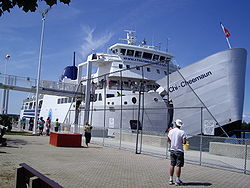
could also be found. At Tobermory, Highway 6 is designated via Carlton Road and Front Street, where motorists wait for the Chi-Cheemaun
Ferry to arrive. In the reverse direction, motorists disembarking from the Chi-Cheemaun ferry use Carlton Street to return to Highway 6. Highway 6 discontinues at Tobermory, and motorists are required to travel on the tolled ferry, MS Chi-Cheemaun, also known as simply Chi-Cheemaun, to continue traveling on Highway 6 on Manitoulin Island
. The journey from Tobermory to South Baymouth on Manitoulin Island takes approximately 1 hour and 45 minutes.
 MS Chi-Cheemaun docks at South Baymouth, and Highway 6 continues as a two-lane highway. Highway 6 is both the main means of connection between Manitoulin Island
and the rest of Ontario and the major highway on Manitoulin Island. Secondary Highways 540 and 542 on Manitoulin Island link back to Highway 6. The section from South Baymouth to the Highway 542 junction has the least AADT, accounting for only 760 automobiles per day in 2002.
Highway 6 continues north, passing through communities such as Manitowaning, Sheguiandah, and Little Current. At Little Current, Highway 6 crosses the North Channel
by the Little Current Swing Bridge
, which swings open for 15 minutes of each daylight hour in the summer to allow boats to pass through the channel. This crossing is the only permanent 2-way one-lane bottleneck of the Ontario King's Highways.
After crossing the North Channel, Highway 6 climbs through the La Cloche Mountains
near Whitefish Falls (see image). Eventually, it arrives in Baldwin, north of Espanola
, ending at Trans-Canada Highway 17
in the community of McKerrow, 117 km from South Baymouth.
By 1848, the 119 km (73.9 mi) Garafraxa Road between Guelph and Sydenham was completed. The remaining section between Hamilton and Guelph, known as the Brock Road, was constructed between 1848 and 1850 over the Guelph and Dundas wagon road. The wagon road, merely a trail through the forest, was cleared by the Canada Company
in the 1820s.
From its official opening in 1920 until March 31, 1997, Highway 6's southern terminus was the Highway 24
junction just west of Port Dover. On April 1, 1997, the Ontario government downloaded many highways in the province, among which was the portion of Highway 6 from the Highway 24 junction to St. Patrick Street. This 7.7 km (4.8 mi) section, which was downloaded to the local county government, is now known as Norfolk County Highway 6. After October 15, 1997, Highway 6 was routed via Upper James Street
, York Boulevard
, Main Street
, and James Street South
. This section was downloaded back to the Hamilton government when the new Highway 6 By-Pass, a 2-lane freeway for the most part, was completed (see below).
Prior to 1982, Highway 6 on Manitoulin Island and northward towards Espanola was known as Highway 68, but in that year it was redesignated as part of Highway 6 despite the discontinuous route (though some would consider the Tobermorry ferry route part of the highway corridor). During the winter months, the highway is discontinuous. Apart from Highway 407 and the international crossing toll bridges, it is the only provincial highway that requires a toll to travel any part of its length.
Ontario
Ontario is a province of Canada, located in east-central Canada. It is Canada's most populous province and second largest in total area. It is home to the nation's most populous city, Toronto, and the nation's capital, Ottawa....
. It crosses a distance of 480 km (298.3 mi) between Port Dover
Port Dover, Ontario
Port Dover is an unincorporated community and former town located in Norfolk County, Ontario, Canada on the north shore of Lake Erie.The community was the subject of an American raid during the War of 1812, on May 14, 1814....
on the north shore of Lake Erie
Lake Erie
Lake Erie is the fourth largest lake of the five Great Lakes in North America, and the tenth largest globally. It is the southernmost, shallowest, and smallest by volume of the Great Lakes and therefore also has the shortest average water residence time. It is bounded on the north by the...
and Espanola
Espanola, Ontario
Espanola is a town in Northern Ontario, Canada, and is the seat of Sudbury District. It is situated on the Spanish River, approximately 70 kilometres west of downtown Sudbury, and just south of the junction of Highway 6 and Highway 17.- History :The name "Espanola" has been attributed to a story...
on the northern shore of Lake Huron
Lake Huron
Lake Huron is one of the five Great Lakes of North America. Hydrologically, it comprises the larger portion of Lake Michigan-Huron. It is bounded on the east by the Canadian province of Ontario and on the west by the state of Michigan in the United States...
, ending at the Trans-Canada Highway
Trans-Canada Highway
The Trans-Canada Highway is a federal-provincial highway system that joins the ten provinces of Canada. It is, along with the Trans-Siberian Highway and Australia's Highway 1, one of the world's longest national highways, with the main route spanning 8,030 km...
(Highway 17) in McKerrow.
Port Dover to Hamilton
Highway 6 begins at Saint Patrick Street in the community of Port Dover, and stretch northward as a two-lane, undivided highway. The road travels into Haldimand CountyHaldimand County, Ontario
Haldimand is a rural city-status single-tier municipality on the Niagara Peninsula in Southern Ontario, Canada, on the north shore of Lake Erie, and on the Grand River. Municipal offices are located in Cayuga....
, through communities such as Jarvis
Jarvis, Ontario
Jarvis is a small community in Haldimand County, Ontario, Canada. Jarvis is located near the towns of Simcoe, Townsend, Cayuga, Port Dover and Hagersville. It is located at the crossroads of Highway 3 and Highway 6.- Facilities :...
and Hagersville
Hagersville, Ontario
Hagersville is a community in Haldimand County, Ontario which gained international notoriety in 1990 for a gigantic uncontrolled tire fire which spewed toxic smoke for seventeen days...
, and the traffic flow increases. By the time the highway reaches Caledonia
Caledonia, Ontario
Caledonia is a small riverside community and former town located on the Grand River in Haldimand County, Ontario, Canada. Haldimand County is in the western part of the Niagara Peninsula, and had a population of 43,280 in 2001. The current mayor of Haldimand County is Ken Hewitt; Caledonia is...
, the road by-passes the former Highway 6 section (Argyle Street), which passes the town centre of Caledonia. With the newly built by-pass, Highway 6 is routed outside the urban centre of Caledonia. The Caledonia By-Pass was opened in 1983, and is a two-lane undivided freeway . The bypass terminates at Greens Road on the north side of Caledonia and Highway 6 proceeds eastbound on Greens Road for approximately 500m to Argyle St North. Highway 6 then turns north on a 4-lane undivided alignment for 5 km. Much of the old alignment north to near Rymal Road remains provincially maintained as unsigned Highway 7273. In Hamilton, Highway 6 now uses a new alignment from Highway 403 to south of the Hamilton Airport
Hamilton/John C. Munro International Airport
John C. Munro Hamilton International Airport or Hamilton International, , is an international airport in Hamilton, Ontario, Canada. It is named for John C...
, connecting with the southerly leg to Caledonia and Port Dover. The new alignment opened as an undivided two-lane freeway
Two-lane freeway
A two-lane expressway is an expressway with only one lane in each direction, and usually no median barrier. It may be built that way because of constraints, or may be intended for expansion once traffic volumes rise. The term super two is often used by roadgeeks for this type of road, but traffic...
; it is expected to expand to a full 4-lane divided highway, and to extend to past Caledonia, by some time in the 2010s. As the road meets Highway 403
Highway 403 (Ontario)
King's Highway 403, also known as Highway 403, is a 400-series highway in the Canadian province of Ontario that travels between Woodstock and Mississauga, branching off from and reuniting with Highway 401 at both ends and travelling south of it through Hamilton and Mississauga. It is concurrent...
, Highway 6 merges with Highway 403, and there is a concurrency
Concurrency (road)
A concurrency, overlap, or coincidence in a road network is an instance of one physical road bearing two or more different highway, motorway, or other route numbers...
for 17 kilometres. The concurrency ends at the Highway 6 junction, at the Hamilton/Burlington
Burlington, Ontario
Burlington , is a city located in Halton Region at the western end of Lake Ontario. Burlington is part of the Greater Toronto Area, and is also included in the Hamilton Census Metropolitan Area. Physically, Burlington lies between the north shore of Lake Ontario and the Niagara Escarpment...
boundary, near the Royal Botanical Gardens.
Hamilton to Guelph
Though most of the route is five lanes — two travel lanes in each direction, plus one centre lane for left turns — the section in Wellington CountyWellington County, Ontario
Wellington County is a county located in Southwestern Ontario, Canada. The county seat is Guelph, a city which is politically independent, but Guelph's status as the seat means it houses the county's administrative offices...
from Puslinch
Puslinch, Ontario
Puslinch is a township in south-central Ontario, Canada, in the County of Wellington south of Guelph. The area is rich in natural gas resources. The main source of production is agricultural, bottling and mining. Mining has been dominant throughout the county. About half of the township is...
to Morriston has remained two lanes because of its route through several small towns and a lack of available property for widening; this area therefore suffers from significant congestion. A new alignment, connecting to the Hanlon Parkway
Hanlon Parkway
The Hanlon Parkway is a high-capacity at-grade suburban expressway in the city of Guelph, Ontario, Canada, which connects it with Highway 401. It runs in a general north-south direction in the city's west end. It is signed as Highway 6 for its whole length; from Wellington Street to Woodlawn Road,...
at Highway 401, is being considered to bypass this troubled section. The section where Highway 6 is concurrent with Highway 401 has the highest AADT (Annual Average Daily Traffic), at 85,000 automobiles per day in 2002. High travel speeds in the five-lane section, and typical flow varies between 100 km/h (65 mph) and 120 km/h (75 mph).
The section of Highway 6 between Highway 403
Highway 403 (Ontario)
King's Highway 403, also known as Highway 403, is a 400-series highway in the Canadian province of Ontario that travels between Woodstock and Mississauga, branching off from and reuniting with Highway 401 at both ends and travelling south of it through Hamilton and Mississauga. It is concurrent...
in Hamilton
Hamilton, Ontario
Hamilton is a port city in the Canadian province of Ontario. Conceived by George Hamilton when he purchased the Durand farm shortly after the War of 1812, Hamilton has become the centre of a densely populated and industrialized region at the west end of Lake Ontario known as the Golden Horseshoe...
and Clappison's Corners (the intersection at Hwy 5 West) was converted in 2009 to a controlled access freeway with an interchange at York Road. The interchange opened on May 23, 2009, and simultaneously, the intersection where Northcliffe/Plains Road met Highway 6 was closed permanently. (A new service road was built on either side to connect Plains Road and various other residential streets to the York Road interchange.) This section of Highway 6 has two southbound lanes and three northbound, the extra lane being for trucks climbing the steep escarpment, as well as high mast lighting and a full concrete median barrier.
In Guelph, the road travels along the full length of the Hanlon Parkway
Hanlon Parkway
The Hanlon Parkway is a high-capacity at-grade suburban expressway in the city of Guelph, Ontario, Canada, which connects it with Highway 401. It runs in a general north-south direction in the city's west end. It is signed as Highway 6 for its whole length; from Wellington Street to Woodlawn Road,...
- a 4-lane, controlled access and divided highway with signalized level crossings. The Ministry of Transportation is presently investigating the possibility of changing these intersections into grade-separated interchanges. For 4 km Highway 6 is concurrent with Highway 7
Highway 7 (Ontario)
King's Highway 7, commonly referred to as Highway 7 and historically as the Northern Highway, is a provincially maintained highway in the Canadian province of Ontario...
, from the Wellington Street interchange
Interchange (road)
In the field of road transport, an interchange is a road junction that typically uses grade separation, and one or more ramps, to permit traffic on at least one highway to pass through the junction without directly crossing any other traffic stream. It differs from a standard intersection, at which...
north to where the Hanlon Parkway ends at Woodlawn Road. At Woodlawn, Highway 7 veers west, and Highway 6 continues east. Following Woodlawn, Highway 6 then veers north onto Woolwich Street, leaving the city of Guelph.
Guelph to Owen Sound
Fergus, Ontario
Fergus is the largest community in Centre Wellington, a township within Wellington County in Ontario, Canada. It lies on the Grand River about 25 km north of Guelph.-History:...
(at Wellington County Road 18); Arthur
Arthur, Ontario
Arthur is a community located just north of Hwy 6 and Wellington Road 109 in the township of Wellington North, Ontario, Canada. Formerly an independent village, Arthur was amalgamated into Wellington North on January 1, 1999.-History:...
(at Wellington County Road 12, 14, and 109 junction); Mount Forest
Mount Forest, Ontario
Mount Forest is an unincorporated community located on the junction of the 6 and the 89 in the township of Wellington North, Ontario. The town's motto is "High, Happy, Healthy", which can be seen on the water tower when approaching the town from the south....
(at the Highway 89 junction); and Durham
Durham, Ontario
Durham is a community in the municipality of West Grey, Grey County, Ontario, Canada. Durham is located near the base of the Bruce Peninsula.-Location:...
(at Grey County Road 4).
32 km north of Durham, Highway 6 is concurrent with Highway 10
Highway 10 (Ontario)
King's Highway 10, commonly referred to as Highway 10 and historically as the Toronto–Sydenham Road, is a provincially maintained highway in the Canadian province of Ontario...
at the community of Chatsworth
Chatsworth, Ontario
Chatsworth is a township in south-western Ontario, Canada, in Grey County, located at the headwaters of the Styx River, the Saugeen River, the Sauble River, the Bighead River, the Spey River, and the Sydenham River....
. For the next 13 km, Highway 6 remains concurrent with Highway 10 until it approaches the outer edge of the urban area of Owen Sound. There is an election promise to upgrade this 13 km to a 400-series Highway
400-series highways (Ontario)
The 400-series highways are a network of controlled-access highways throughout the southern portion of the Canadian province of Ontario, forming a special subset of the provincial highway system. They are analogous to the Interstate Highway System in the United States or the British Motorway...
and rename it Highway 410.
Near Owen Sound City Centre, and upon the end of Highway 10, Highway 6 is concurrent with Highway 21
Highway 21 (Ontario)
King's Highway 21, commonly referred to as Highway 21, is a provincially maintained highway in the Canadian province of Ontario that begins at Highway 402 mid-way between Sarnia and London and ends at Highway 6, Highway 10 and Highway 26 in Owen Sound...
for 6 km westward to Springmount. This portion is a 4-lane arterial road (as seen in the image).
Owen Sound to Tobermory
Bruce Peninsula
The Bruce Peninsula is a peninsula in Ontario, Canada that lies between Georgian Bay and the main basin of Lake Huron. The peninsula extends roughly northwestwards from the rest of Southern Ontario, pointing towards Manitoulin Island, with which it forms the widest strait joining Georgian Bay to...
. The road remains as a two-lane highway for its full length up to Tobermory. Highway 6 spans 110 km on the Bruce Peninsula. Highway 6 passes through communities such as Shallow Lake, Hepworth, Wiarton
Wiarton, Ontario
Wiarton is a community in Bruce County, Ontario, at the western end of Colpoys Bay, an inlet off Georgian Bay, on the Bruce Peninsula. The community is part of the town of South Bruce Peninsula, Ontario....
, and Ferndale
Ferndale, Bruce County, Ontario
Ferndale is a hamlet in Bruce County, Ontario, Canada. Ferndale is west of Lion's Head, halfway between Owen Sound and Tobermory on the Bruce Peninsula, located at Highway 6 and Bruce Rd. 9....
. Highway 6 is also named as Berford Street in Wiarton, and 10th Street in Owen Sound. Along the road, Bruce Peninsula National Park
Bruce Peninsula National Park
Bruce Peninsula National Park is a national park on the Bruce Peninsula in Ontario, Canada. Located on a part of the Niagara Escarpment, the park comprises 156 square kilometres and is one of the largest protected areas in southern Ontario, forming the core of UNESCO's Niagara Escarpment World...
could also be found. At Tobermory, Highway 6 is designated via Carlton Road and Front Street, where motorists wait for the Chi-Cheemaun
Chi-Cheemaun
MS Chi-Cheemaun is a passenger and car ferry in Ontario, Canada, which traverses Lake Huron between Tobermory on Bruce Peninsula and South Baymouth on Manitoulin Island. The ferry connects the two geographically separate portions of Highway 6 and is the vessel that replaced MS Norgoma and SS...
Ferry to arrive. In the reverse direction, motorists disembarking from the Chi-Cheemaun ferry use Carlton Street to return to Highway 6. Highway 6 discontinues at Tobermory, and motorists are required to travel on the tolled ferry, MS Chi-Cheemaun, also known as simply Chi-Cheemaun, to continue traveling on Highway 6 on Manitoulin Island
Manitoulin Island
Manitoulin Island is a Canadian island in Lake Huron, in the province of Ontario. It is the largest island in a freshwater lake in the world. In addition to the historic Anishinaabe and European settlement of the island, archeological discoveries at Sheguiandah have demonstrated Paleo-Indian and...
. The journey from Tobermory to South Baymouth on Manitoulin Island takes approximately 1 hour and 45 minutes.
South Baymouth to McKerrow
Manitoulin Island
Manitoulin Island is a Canadian island in Lake Huron, in the province of Ontario. It is the largest island in a freshwater lake in the world. In addition to the historic Anishinaabe and European settlement of the island, archeological discoveries at Sheguiandah have demonstrated Paleo-Indian and...
and the rest of Ontario and the major highway on Manitoulin Island. Secondary Highways 540 and 542 on Manitoulin Island link back to Highway 6. The section from South Baymouth to the Highway 542 junction has the least AADT, accounting for only 760 automobiles per day in 2002.
Highway 6 continues north, passing through communities such as Manitowaning, Sheguiandah, and Little Current. At Little Current, Highway 6 crosses the North Channel
North Channel (Ontario)
The North Channel is the body of water along the north shore of Lake Huron, in the Canadian province of Ontario. It is bordered on the east by Georgian Bay, on the west by the St. Marys River, to the north by the eastern Algoma District and to the south by the islands of Manitoulin, Cockburn,...
by the Little Current Swing Bridge
Little Current Swing Bridge
The Little Current Swing Bridge is a swing bridge in the Canadian province of Ontario, located at the community of Little Current in the town of Northeastern Manitoulin and the Islands....
, which swings open for 15 minutes of each daylight hour in the summer to allow boats to pass through the channel. This crossing is the only permanent 2-way one-lane bottleneck of the Ontario King's Highways.
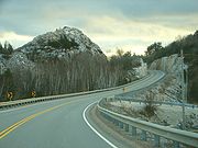
After crossing the North Channel, Highway 6 climbs through the La Cloche Mountains
La Cloche Mountains
The La Cloche Mountains, also called the La Cloche Range, are a range of hills in Northern Ontario, along the northern shore of Lake Huron near Manitoulin Island. The hills are located in the Canadian Shield, and are composed primarily of white quartzite.They extend roughly from La Cloche...
near Whitefish Falls (see image). Eventually, it arrives in Baldwin, north of Espanola
Espanola, Ontario
Espanola is a town in Northern Ontario, Canada, and is the seat of Sudbury District. It is situated on the Spanish River, approximately 70 kilometres west of downtown Sudbury, and just south of the junction of Highway 6 and Highway 17.- History :The name "Espanola" has been attributed to a story...
, ending at Trans-Canada Highway 17
Highway 17 (Ontario)
King's Highway 17, more commonly known as Highway 17, is a provincially maintained highway and the primary route of the Trans-Canada Highway through the Canadian province of Ontario. It begins at the Manitoba border west of Kenora and ends south of Arnprior at the western terminus of Highway 417, ...
in the community of McKerrow, 117 km from South Baymouth.
History
Planning for the original section of what would become Highway 6 began in 1837, when Charles Rankin was hired to survey a line between Guelph and a new town site on the southern shore of Georgian Bay known as Sydenham (renamed to Owen Sound in 1851). A new line was surveyed in 1840 by John McDonald, and construction along this route began. Around the same time, the Van Norman Company constructed a plank road between Port Dover and Hamilton known as both the Hamilton Plank Road and the Dover Road.By 1848, the 119 km (73.9 mi) Garafraxa Road between Guelph and Sydenham was completed. The remaining section between Hamilton and Guelph, known as the Brock Road, was constructed between 1848 and 1850 over the Guelph and Dundas wagon road. The wagon road, merely a trail through the forest, was cleared by the Canada Company
Canada Company
The Canada Company was a large private chartered British land development company, incorporated by an act of British parliament on July 27, 1825, to aid the colonization of Upper Canada. Canada Company assisted emigrants by providing good ships, low fares, implements and tools,and inexpensive land....
in the 1820s.
From its official opening in 1920 until March 31, 1997, Highway 6's southern terminus was the Highway 24
Ontario Highway 24
Highway 24 is a highway in the Canadian province of Ontario which presently begins at Highway 3 in Simcoe, and ends at Highway 401, in Cambridge. Highway 24 runs in a north/south direction and has been in service since 1927...
junction just west of Port Dover. On April 1, 1997, the Ontario government downloaded many highways in the province, among which was the portion of Highway 6 from the Highway 24 junction to St. Patrick Street. This 7.7 km (4.8 mi) section, which was downloaded to the local county government, is now known as Norfolk County Highway 6. After October 15, 1997, Highway 6 was routed via Upper James Street
Upper James Street (Hamilton, Ontario)
Upper James Street, is an Upper City arterial road in Hamilton, Ontario, Canada. It starts at the Claremont Access, a mountain-access road in the north, and extends southward towards the John C. Munro Hamilton International Airport where it then changes its name to the Hamilton Port Dover Plain...
, York Boulevard
York Boulevard (Hamilton, Ontario)
York Boulevard is a Lower City arterial road in Hamilton, Ontario, Canada. Formerly known as Highway 2 and Highway 6,starts off in Burlington, Ontario at Plains Road West as a two-way arterial road that wraps around and over the Hamilton Harbour and enters the city of Hamilton in the West-end past...
, Main Street
Main Street (Hamilton, Ontario)
Main Street, is a Lower City arterial road in Hamilton, Ontario, Canada. It starts east of Wilson Street in Ancaster at White Chapel Cemetery as a two-way street and switches over to a one-way street at Paradise Road South, in Westdale, where it continues up to the Delta where it once again...
, and James Street South
James Street (Hamilton, Ontario)
James Street is a Lower City arterial road in Hamilton, Ontario, Canada. It starts off at the base of the Niagara Escarpment from James Mountain Road, a mountain-access road in the city, originally was a one-way street going south throughout but now has sections of it that are two-way...
. This section was downloaded back to the Hamilton government when the new Highway 6 By-Pass, a 2-lane freeway for the most part, was completed (see below).
Prior to 1982, Highway 6 on Manitoulin Island and northward towards Espanola was known as Highway 68, but in that year it was redesignated as part of Highway 6 despite the discontinuous route (though some would consider the Tobermorry ferry route part of the highway corridor). During the winter months, the highway is discontinuous. Apart from Highway 407 and the international crossing toll bridges, it is the only provincial highway that requires a toll to travel any part of its length.