

U.S. Route 9
Encyclopedia
U.S. Route 9 is a north–south United States highway in the states of Delaware
, New Jersey
, and New York
in the United States
. It is one of only two U.S. highways with a ferry connection (the Cape May-Lewes Ferry
, between Lewes, Delaware
, and Cape May, New Jersey
); the other being US 10
. US 9 is signed east–west in Delaware
and north–south on the rest of its route. The southern terminus of the route is in Laurel, Delaware
at an intersection with U.S. Route 13
, while the highway's northern terminus is at a junction with Interstate 87
in Champlain, NY
, where the roadway continues north as the unsigned NY 471B, which ends in a cul-de-sac just short of the Canadian border.
New Jersey, where it is a wide four-lane (or six-lane) divided strip, especially during much of its concurrency with U.S. 1 and in Middlesex and Monmouth Counties. New York boasts a few similar sections, as well as two short expressway sections near Albany.
In New Jersey and New York, much of Route 9 runs parallel to the Garden State Parkway
and Interstate 87
.
, running west from U.S. Route 13
in Laurel
, passing through Georgetown
, east to Lewes
, where it leads to the Cape May-Lewes Ferry
, which carries U.S. 9 across the Delaware Bay
to New Jersey. U.S. 9 was extended to Delaware by way of the Cape-May Lewes Ferry in the 1970s, replacing Delaware Route 28 between Laurel and Georgetown and Delaware Route 18
between Georgetown and Lewes. U.S. 9 runs concurrent with Delaware Route 404 between Georgetown and the Five Points
intersection near Lewes.
, through the Atlantic City suburbs, until joining it briefly through the Pine Barrens (New Jersey)
region of Southern New Jersey. Route 9 rejoins the Garden State Parkway in the Toms River
area, and then veers away from it, becoming a divided highway at Lakewood. The highway follows a more inland route through Howell Township
, Marlboro Township
, Freehold Township, Manalapan Township, Old Bridge
, Sayreville and into Perth Amboy
. From here, the road resumes its parallel course with the Garden State Parkway. After crossing the Edison Bridge over the Raritan River
, it merges with US 1
in Woodbridge. The concurrency, an important and busy regional artery, continues past Newark Liberty International Airport
and over the Pulaski Skyway
, finally leaving the state along with Route 1 and I-95
via the George Washington Bridge
.

 A large section in northeast New Jersey and a small section in southern New York is concurrent
with U.S. Route 1
. Route shields on this section, which includes the Pulaski Skyway
, often show both numbers in the same shield, with a dash or ampersand between (1–9 or 1&9). It is known locally as "1 and 9."
's Broadway
north of it, passing over the northern tip of Manhattan
Island via the toll-free Broadway Bridge, through the Bronx
and into Westchester County
, where in some towns it follows the old Albany Post Road
, which dates from the early days of the nation's existence.
Following the Hudson River
closely as a busy surface road through the many suburban river villages and past National Historic Landmark
s such as Sunnyside
and Kykuit
, 9 becomes the Croton Expressway between Croton-on-Hudson
and Peekskill
. That section ends at the Annsville Circle junction with US 6
and 202
, where 9 returns to two-lane status as it follows the old post road inland, away from the river. At Fishkill
, it becomes a six-lane divided strip until reaching the Poughkeepsie
city limit. It then narrows to a four-lane divided strip which lasts until it intersects St. Andrews Rd, just north of the Hyde Park/Poughkeepsie town line where it returns to two-lane status as it goes through Hyde Park
and past its historic sites.
At Red Hook
9 veers inland again, becoming a two-lane country road through Columbia County
save for the outskirts of Hudson
. In Rensselaer County
it widens again as it intersects I-90
and then joins US 20
to Albany
, where it crosses the Hudson at the Dunn Memorial Bridge
. It is a busy surface road through the state capital, becoming a strip in its northern suburbs, taking traffic eventually to Saratoga Springs
and Lake George
, at the edge of the Adirondack Park.
The Adirondack
section of US 9 is the least trafficked of the road, returning to two lanes as it runs through vast tracts of forested wilderness and occasional hamlets. Almost 100 miles (161 km) to the north, it leaves the park and runs along or near Lake Champlain
to Plattsburgh
. North of there, it is once again a two-lane road all the way to Champlain
and the cul-de-sac just shy of the border.
in 1964, US 9 ended on Lafayette Street in Cape May, New Jersey
. It was re-routed to the west, via Sandman Boulevard and Lincoln Avenues, to meet the new ferry, and its southern stub into Cape May was renumbered as NJ 109
.
Originally, the road continued north across the border (as Route 9 towards Montreal
) through the customs facilities now used by Interstate 87
/Autoroute 15
. The official northern terminus (the point where the END US 9 sign is posted) is just south of the interchange with I-87, less than a mile from customs.
Delaware
Delaware is a U.S. state located on the Atlantic Coast in the Mid-Atlantic region of the United States. It is bordered to the south and west by Maryland, and to the north by Pennsylvania...
, New Jersey
New Jersey
New Jersey is a state in the Northeastern and Middle Atlantic regions of the United States. , its population was 8,791,894. It is bordered on the north and east by the state of New York, on the southeast and south by the Atlantic Ocean, on the west by Pennsylvania and on the southwest by Delaware...
, and New York
New York
New York is a state in the Northeastern region of the United States. It is the nation's third most populous state. New York is bordered by New Jersey and Pennsylvania to the south, and by Connecticut, Massachusetts and Vermont to the east...
in the United States
United States
The United States of America is a federal constitutional republic comprising fifty states and a federal district...
. It is one of only two U.S. highways with a ferry connection (the Cape May-Lewes Ferry
Cape May-Lewes Ferry
The Cape May – Lewes Ferry is a ferry system that traverses a 17-mile crossing of the Delaware Bay to connect Cape May, New Jersey with Lewes, Delaware. The ferry doubles as a section of U.S. Route 9.-The system:...
, between Lewes, Delaware
Lewes, Delaware
Lewes is an incorporated city in Sussex County, Delaware, USA, on the Delmarva Peninsula. According to the 2010 census, the population is 2,747, a decrease of 6.3% from 2000....
, and Cape May, New Jersey
Cape May, New Jersey
Cape May is a city at the southern tip of Cape May Peninsula in Cape May County, New Jersey, where the Delaware Bay meets the Atlantic Ocean and is one of the country's oldest vacation resort destinations. It is part of the Ocean City Metropolitan Statistical Area. As of the 2010 United States...
); the other being US 10
U.S. Route 10
U.S. Route 10 is an east–west United States highway formed in 1926. Though it never became the cross-country highway suggested by the "0" as the last digit of its route number, U.S...
. US 9 is signed east–west in Delaware
Delaware
Delaware is a U.S. state located on the Atlantic Coast in the Mid-Atlantic region of the United States. It is bordered to the south and west by Maryland, and to the north by Pennsylvania...
and north–south on the rest of its route. The southern terminus of the route is in Laurel, Delaware
Laurel, Delaware
As of the census of 2000, there were 3,668 people, 1,389 households, and 957 families residing in the town. The population density was 2,215.9 people per square mile . There were 1,561 housing units at an average density of 943.0 per square mile...
at an intersection with U.S. Route 13
U.S. Route 13
U.S. Route 13 is a north–south U.S. highway established in 1926 that runs for from Interstate 95 just north of Fayetteville, North Carolina to the northeastern suburbs of Philadelphia, Pennsylvania, in Morrisville. In all, it traverses five states in the Atlantic coastal plain region,...
, while the highway's northern terminus is at a junction with Interstate 87
Interstate 87
Interstate 87 is a Interstate Highway located entirely within New York State in the United States of America. I-87 is the longest intrastate Interstate highway in the Interstate Highway System. Its southern end is at the Bronx approaches of the Robert F. Kennedy Bridge in New York City...
in Champlain, NY
Champlain (town), New York
Champlain is a town in Clinton County, New York, United States. The population was 5,754 at the 2010 census. The town is named after Lake Champlain....
, where the roadway continues north as the unsigned NY 471B, which ends in a cul-de-sac just short of the Canadian border.
Route description
Much of U.S. 9 is a two-lane road, with some expansions near more populous areas. The major exception to this is central and northernNorth Jersey
North Jersey is a colloquial term, with no precise consensus definition, for the northern portion of the U.S. state of New Jersey. A straightforward, noncolloquial term for the region is northern New Jersey.- Two-portion approaches :...
New Jersey, where it is a wide four-lane (or six-lane) divided strip, especially during much of its concurrency with U.S. 1 and in Middlesex and Monmouth Counties. New York boasts a few similar sections, as well as two short expressway sections near Albany.
In New Jersey and New York, much of Route 9 runs parallel to the Garden State Parkway
Garden State Parkway
The Garden State Parkway is a 172.4-mile limited-access toll parkway that stretches the length of New Jersey from the New York line at Montvale, New Jersey, to Cape May at New Jersey's southernmost tip. Its name refers to New Jersey's nickname, the "Garden State." Most New Jersey residents refer...
and Interstate 87
Interstate 87
Interstate 87 is a Interstate Highway located entirely within New York State in the United States of America. I-87 is the longest intrastate Interstate highway in the Interstate Highway System. Its southern end is at the Bronx approaches of the Robert F. Kennedy Bridge in New York City...
.
Delaware
U.S. 9 runs an east–west path through Sussex CountySussex County, Delaware
Sussex County is a county located in the southern part of the U.S. state of Delaware. As of 2010 the population was 197,145, an increase of 25.9% over the previous decade. The county seat is Georgetown. The Seaford Micropolitan Statistical Area includes all of Sussex County.Sussex County is...
, running west from U.S. Route 13
U.S. Route 13
U.S. Route 13 is a north–south U.S. highway established in 1926 that runs for from Interstate 95 just north of Fayetteville, North Carolina to the northeastern suburbs of Philadelphia, Pennsylvania, in Morrisville. In all, it traverses five states in the Atlantic coastal plain region,...
in Laurel
Laurel, Delaware
As of the census of 2000, there were 3,668 people, 1,389 households, and 957 families residing in the town. The population density was 2,215.9 people per square mile . There were 1,561 housing units at an average density of 943.0 per square mile...
, passing through Georgetown
Georgetown, Delaware
Georgetown is a town in Sussex County, Delaware, United States. According to 2010 census figures, the population of the town is 6,422, an increase of 38.3% over the previous decade...
, east to Lewes
Lewes, Delaware
Lewes is an incorporated city in Sussex County, Delaware, USA, on the Delmarva Peninsula. According to the 2010 census, the population is 2,747, a decrease of 6.3% from 2000....
, where it leads to the Cape May-Lewes Ferry
Cape May-Lewes Ferry
The Cape May – Lewes Ferry is a ferry system that traverses a 17-mile crossing of the Delaware Bay to connect Cape May, New Jersey with Lewes, Delaware. The ferry doubles as a section of U.S. Route 9.-The system:...
, which carries U.S. 9 across the Delaware Bay
Delaware Bay
Delaware Bay is a major estuary outlet of the Delaware River on the Northeast seaboard of the United States whose fresh water mixes for many miles with the waters of the Atlantic Ocean. It is in area. The bay is bordered by the State of New Jersey and the State of Delaware...
to New Jersey. U.S. 9 was extended to Delaware by way of the Cape-May Lewes Ferry in the 1970s, replacing Delaware Route 28 between Laurel and Georgetown and Delaware Route 18
Delaware Route 18
Delaware Route 18 is a state highway located in Sussex County, Delaware. It runs from Maryland Route 318 at the Maryland border east of Federalsburg, Maryland to U.S. Route 9 in Georgetown, Delaware...
between Georgetown and Lewes. U.S. 9 runs concurrent with Delaware Route 404 between Georgetown and the Five Points
Five Points, Delaware
Five Points is an unincorporated community in Sussex County, Delaware, United States. Five Points is located at the junction of U.S. Route 9, Delaware Route 1, and Delaware Route 404 west-northwest of Rehoboth Beach....
intersection near Lewes.
New Jersey
From Cape May, U.S. 9 runs north parallel to the Garden State ParkwayGarden State Parkway
The Garden State Parkway is a 172.4-mile limited-access toll parkway that stretches the length of New Jersey from the New York line at Montvale, New Jersey, to Cape May at New Jersey's southernmost tip. Its name refers to New Jersey's nickname, the "Garden State." Most New Jersey residents refer...
, through the Atlantic City suburbs, until joining it briefly through the Pine Barrens (New Jersey)
Pine barrens
Pine barrens, pine plains, sand plains, or pinelands occur throughout the northeastern U.S. from New Jersey to Maine as well as the Midwest and Canada....
region of Southern New Jersey. Route 9 rejoins the Garden State Parkway in the Toms River
Toms River
The Toms River, formerly Tom's River, is a freshwater river and estuary in Ocean County, New Jersey in the United States.The Toms River rises in the Pine Barrens of northern Ocean County and flows southeast and east, fed by several branches, in a meandering course through wetland area and empties...
area, and then veers away from it, becoming a divided highway at Lakewood. The highway follows a more inland route through Howell Township
Howell Township, New Jersey
Howell is a Township in Monmouth County, New Jersey, United States. As of the 2010 United States Census, the township population was 51,075.Howell Township was incorporated as a township by an Act of the New Jersey Legislature on February 23, 1801, from portions of Shrewsbury Township...
, Marlboro Township
Marlboro Township, New Jersey
-Weather:Marlboro is located close to the Atlantic Ocean. Due to the location Marlboro Township has on the Eastern Seaboard, the following weather features are noted:*On average, the warmest month is July where the average high is and the average low is ....
, Freehold Township, Manalapan Township, Old Bridge
Old Bridge Township, New Jersey
Old Bridge Township is a Township in Middlesex County, New Jersey, United States. As of the 2000 United States Census, the township had a total population of 60,456...
, Sayreville and into Perth Amboy
Perth Amboy, New Jersey
Perth Amboy is a city in Middlesex County, New Jersey, United States. The City of Perth Amboy is part of the New York metropolitan area. As of the 2010 United States Census, the city population was 50,814. Perth Amboy is known as the "City by the Bay", referring to Raritan Bay.-Name:The Lenape...
. From here, the road resumes its parallel course with the Garden State Parkway. After crossing the Edison Bridge over the Raritan River
Raritan River
The Raritan River is a major river of central New Jersey in the United States. Its watershed drains much of the mountainous area of the central part of the state, emptying into the Raritan Bay on the Atlantic Ocean.-Description:...
, it merges with US 1
U.S. Route 1
U.S. Route 1 is a major north–south U.S. Highway that serves the East Coast of the United States. It runs 2,377 miles from Fort Kent, Maine at the Canadian border south to Key West, Florida. U.S. 1 generally parallels Interstate 95, though it is significantly farther west between...
in Woodbridge. The concurrency, an important and busy regional artery, continues past Newark Liberty International Airport
Newark Liberty International Airport
Newark Liberty International Airport , first named Newark Metropolitan Airport and later Newark International Airport, is an international airport within the city limits of both Newark and Elizabeth, New Jersey, United States...
and over the Pulaski Skyway
Pulaski Skyway
The General Pulaski Skyway is a four-lane freeway composed of connected bridges in the northeastern part of the U.S. state of New Jersey, carrying the designation of U.S. Route 1/9 for most of its length. The landmark structure has a total length of with the longest bridge spanning...
, finally leaving the state along with Route 1 and I-95
Interstate 95 in New Jersey
Interstate 95 is a major Interstate Highway that traverses the full extent of the East Coast of the United States, from Florida to Maine...
via the George Washington Bridge
George Washington Bridge
The George Washington Bridge is a suspension bridge spanning the Hudson River, connecting the Washington Heights neighborhood in the borough of Manhattan in New York City to Fort Lee, Bergen County, New Jersey. Interstate 95 and U.S. Route 1/9 cross the river via the bridge. U.S...
.
Overlap with US 1
Concurrency (road)
A concurrency, overlap, or coincidence in a road network is an instance of one physical road bearing two or more different highway, motorway, or other route numbers...
with U.S. Route 1
U.S. Route 1 in New Jersey
U.S. Route 1 is a United States highway which parallels the East Coast of the United States, running from Key West, Florida in the south to Fort Kent, Maine at the Canadian border in the north. Of the entire length of the route, of it runs through New Jersey...
. Route shields on this section, which includes the Pulaski Skyway
Pulaski Skyway
The General Pulaski Skyway is a four-lane freeway composed of connected bridges in the northeastern part of the U.S. state of New Jersey, carrying the designation of U.S. Route 1/9 for most of its length. The landmark structure has a total length of with the longest bridge spanning...
, often show both numbers in the same shield, with a dash or ampersand between (1–9 or 1&9). It is known locally as "1 and 9."
New York
U.S. 9 exits shortly after the bridge to go onto New York CityNew York City
New York is the most populous city in the United States and the center of the New York Metropolitan Area, one of the most populous metropolitan areas in the world. New York exerts a significant impact upon global commerce, finance, media, art, fashion, research, technology, education, and...
's Broadway
Broadway (New York City)
Broadway is a prominent avenue in New York City, United States, which runs through the full length of the borough of Manhattan and continues northward through the Bronx borough before terminating in Westchester County, New York. It is the oldest north–south main thoroughfare in the city, dating to...
north of it, passing over the northern tip of Manhattan
Manhattan
Manhattan is the oldest and the most densely populated of the five boroughs of New York City. Located primarily on the island of Manhattan at the mouth of the Hudson River, the boundaries of the borough are identical to those of New York County, an original county of the state of New York...
Island via the toll-free Broadway Bridge, through the Bronx
The Bronx
The Bronx is the northernmost of the five boroughs of New York City. It is also known as Bronx County, the last of the 62 counties of New York State to be incorporated...
and into Westchester County
Westchester County, New York
Westchester County is a county located in the U.S. state of New York. Westchester covers an area of and has a population of 949,113 according to the 2010 Census, residing in 45 municipalities...
, where in some towns it follows the old Albany Post Road
Albany Post Road
The Albany Post Road was a post road - a road used for mail delivery - in the U.S. state of New York. It connected the cities of New York and Albany along the east side of the Hudson River, a service now performed by US 9.The rough route was as follows:...
, which dates from the early days of the nation's existence.
Following the Hudson River
Hudson River
The Hudson is a river that flows from north to south through eastern New York. The highest official source is at Lake Tear of the Clouds, on the slopes of Mount Marcy in the Adirondack Mountains. The river itself officially begins in Henderson Lake in Newcomb, New York...
closely as a busy surface road through the many suburban river villages and past National Historic Landmark
National Historic Landmark
A National Historic Landmark is a building, site, structure, object, or district, that is officially recognized by the United States government for its historical significance...
s such as Sunnyside
Sunnyside (Tarrytown, New York)
Sunnyside is a historic house on 10 acres of grounds alongside the Hudson River in Tarrytown, New York. It was formerly the home of noted early American author Washington Irving, best known for his short stories "The Legend of Sleepy Hollow" and "Rip Van Winkle", and is a National Historic...
and Kykuit
Kykuit
Kykuit , also known as John D. Rockefeller Estate, is a 40-room National Trust house in Westchester County, New York, built by the oil businessman, philanthropist and founder of the prominent Rockefeller family, John D. Rockefeller, and his son, John D...
, 9 becomes the Croton Expressway between Croton-on-Hudson
Croton-on-Hudson, New York
Croton-on-Hudson is a village in Westchester County, New York, United States. The population was 8,070 at the 2010 census. It is located in the town of Cortlandt, in New York City's northern suburbs...
and Peekskill
Peekskill, New York
Peekskill is a city in Westchester County, New York. It is situated on a bay along the east side of the Hudson River, across from Jones Point.This community was known to be an early American industrial center, primarily for its iron plow and stove products...
. That section ends at the Annsville Circle junction with US 6
U.S. Route 6 in New York
U.S. Route 6 is a part of the U.S. Highway System that runs from Bishop, California, to Provincetown, Massachusetts. In New York, US 6 extends from the Pennsylvania state line at Port Jervis to the Connecticut state line east of Brewster...
and 202
U.S. Route 202
U.S. Route 202 is a highway stretching from Delaware to Maine, also passing through the states of Pennsylvania, New Jersey, New York, Connecticut, Massachusetts, and New Hampshire....
, where 9 returns to two-lane status as it follows the old post road inland, away from the river. At Fishkill
Fishkill, New York
Fishkill is an upscale village within the much larger town, Town of Fishkill, one of the fastest growing towns in the region, in Dutchess County, New York, USA. The village population was 1,735 at the 2000 census...
, it becomes a six-lane divided strip until reaching the Poughkeepsie
Poughkeepsie (city), New York
Poughkeepsie is a city in the state of New York, United States, which serves as the county seat of Dutchess County. Poughkeepsie is located in the Hudson River Valley midway between New York City and Albany...
city limit. It then narrows to a four-lane divided strip which lasts until it intersects St. Andrews Rd, just north of the Hyde Park/Poughkeepsie town line where it returns to two-lane status as it goes through Hyde Park
Hyde Park, New York
Hyde Park is a town located in the northwest part of Dutchess County, New York, United States, just north of the city of Poughkeepsie. The town is most famous for being the hometown of U.S. President Franklin D. Roosevelt....
and past its historic sites.
At Red Hook
Red Hook, New York
Red Hook is a town in Dutchess County, New York, United States. The population was reported to be 11,319 during the 2010 census. The name is supposedly derived from the red foliage on trees on a small strip of land on the Hudson River. The town contains two villages; the village of Red Hook and the...
9 veers inland again, becoming a two-lane country road through Columbia County
Columbia County, New York
Columbia County is a county located in the U.S. state of New York. As of the 2010 census, the population was 63,096. The county seat is Hudson. The name comes from the Latin feminine form of the name of Christopher Columbus, which was at the time of the formation of the county a popular proposal...
save for the outskirts of Hudson
Hudson, New York
Hudson is a city located along the west border of Columbia County, New York, United States. The city is named after the adjacent Hudson River and ultimately after the explorer Henry Hudson.Hudson is the county seat of Columbia County...
. In Rensselaer County
Rensselaer County, New York
Rensselaer County is a county in the U.S. state of New York. As of the 2010 census, the population was 159,429. Its name is in honor of the family of Kiliaen van Rensselaer, the original Dutch owner of the land in the area. Its county seat is Troy...
it widens again as it intersects I-90
Interstate 90
Interstate 90 is the longest Interstate Highway in the United States at . It is the northernmost coast-to-coast interstate, and parallels US 20 for the most part. Its western terminus is in Seattle, at Edgar Martinez Drive S. near Safeco Field and CenturyLink Field, and its eastern terminus is in...
and then joins US 20
U.S. Route 20 in New York
U.S. Route 20 is a part of the U.S. Highway System that runs from Newport, Oregon, to Boston, Massachusetts. In the U.S. state of New York, US 20 extends from the Pennsylvania state line at Ripley to the Massachusetts state line in the Berkshire Mountains. US 20 is the longest...
to Albany
Albany, New York
Albany is the capital city of the U.S. state of New York, the seat of Albany County, and the central city of New York's Capital District. Roughly north of New York City, Albany sits on the west bank of the Hudson River, about south of its confluence with the Mohawk River...
, where it crosses the Hudson at the Dunn Memorial Bridge
Dunn Memorial Bridge
The Dunn Memorial Bridge, officially known as the Private Parker F. Dunn Memorial Bridge, carries US 9 and US 20 across the Hudson River between Albany, New York and Rensselaer, New York. Completed in 1967 to replace an earlier span bearing the same name, the highway bridge has a steel girder...
. It is a busy surface road through the state capital, becoming a strip in its northern suburbs, taking traffic eventually to Saratoga Springs
Saratoga Springs, New York
Saratoga Springs, also known as simply Saratoga, is a city in Saratoga County, New York, United States. The population was 26,586 at the 2010 census. The name reflects the presence of mineral springs in the area. While the word "Saratoga" is known to be a corruption of a Native American name, ...
and Lake George
Lake George (village), New York
The Village of Lake George is a village within the town of Lake George in Warren County, New York, United States. The population was 985 at the 2000 census. It is part of the Glens Falls Metropolitan Statistical Area...
, at the edge of the Adirondack Park.
The Adirondack
Adirondack Mountains
The Adirondack Mountains are a mountain range located in the northeastern part of New York, that runs through Clinton, Essex, Franklin, Fulton, Hamilton, Herkimer, Lewis, Saint Lawrence, Saratoga, Warren, and Washington counties....
section of US 9 is the least trafficked of the road, returning to two lanes as it runs through vast tracts of forested wilderness and occasional hamlets. Almost 100 miles (161 km) to the north, it leaves the park and runs along or near Lake Champlain
Lake Champlain
Lake Champlain is a natural, freshwater lake in North America, located mainly within the borders of the United States but partially situated across the Canada—United States border in the Canadian province of Quebec.The New York portion of the Champlain Valley includes the eastern portions of...
to Plattsburgh
Plattsburgh (city), New York
Plattsburgh is a city in and county seat of Clinton County, New York, United States. The population was 19,989 at the 2010 census. The population of the unincorporated areas within the Town of Plattsburgh was 11,870 as of the 2010 census; making the population for the immediate, urban Plattsburgh,...
. North of there, it is once again a two-lane road all the way to Champlain
Champlain (town), New York
Champlain is a town in Clinton County, New York, United States. The population was 5,754 at the 2010 census. The town is named after Lake Champlain....
and the cul-de-sac just shy of the border.
Original termini
Prior to the opening of the Cape May-Lewes FerryCape May-Lewes Ferry
The Cape May – Lewes Ferry is a ferry system that traverses a 17-mile crossing of the Delaware Bay to connect Cape May, New Jersey with Lewes, Delaware. The ferry doubles as a section of U.S. Route 9.-The system:...
in 1964, US 9 ended on Lafayette Street in Cape May, New Jersey
Cape May, New Jersey
Cape May is a city at the southern tip of Cape May Peninsula in Cape May County, New Jersey, where the Delaware Bay meets the Atlantic Ocean and is one of the country's oldest vacation resort destinations. It is part of the Ocean City Metropolitan Statistical Area. As of the 2010 United States...
. It was re-routed to the west, via Sandman Boulevard and Lincoln Avenues, to meet the new ferry, and its southern stub into Cape May was renumbered as NJ 109
Route 109 (New Jersey)
Route 109 is a state highway located in Cape May County, New Jersey, United States. The route runs from Jackson Street in Cape May north to an intersection with U.S. Route 9 in Lower Township...
.
Originally, the road continued north across the border (as Route 9 towards Montreal
Montreal
Montreal is a city in Canada. It is the largest city in the province of Quebec, the second-largest city in Canada and the seventh largest in North America...
) through the customs facilities now used by Interstate 87
Interstate 87
Interstate 87 is a Interstate Highway located entirely within New York State in the United States of America. I-87 is the longest intrastate Interstate highway in the Interstate Highway System. Its southern end is at the Bronx approaches of the Robert F. Kennedy Bridge in New York City...
/Autoroute 15
Quebec Autoroute 15
Autoroute 15 is a highway in western Quebec, Canada...
. The official northern terminus (the point where the END US 9 sign is posted) is just south of the interchange with I-87, less than a mile from customs.
Major intersections
- New York State ThruwayNew York State ThruwayThe New York State Thruway is a system of limited-access highways located within the state of New York in the United States. The system, known officially as the Governor Thomas E. Dewey Thruway for former New York Governor Thomas E. Dewey, is operated by the New York State Thruway Authority and...
in TarrytownTarrytown, New YorkTarrytown is a village in the town of Greenburgh in Westchester County, New York, United States. It is located on the eastern bank of the Hudson River, about north of midtown Manhattan in New York City, and is served by a stop on the Metro-North Hudson Line... - Interstate 84Interstate 84 (east)Interstate 84 is an Interstate Highway extending from Dunmore, Pennsylvania at an interchange with Interstate 81 to Sturbridge, Massachusetts, at an interchange with the Massachusetts Turnpike . I-84 has mile-log junction numbering in Pennsylvania; otherwise, exit numbers are roughly sequential...
in FishkillFishkill, New YorkFishkill is an upscale village within the much larger town, Town of Fishkill, one of the fastest growing towns in the region, in Dutchess County, New York, USA. The village population was 1,735 at the 2000 census... - Interstate 90Interstate 90Interstate 90 is the longest Interstate Highway in the United States at . It is the northernmost coast-to-coast interstate, and parallels US 20 for the most part. Its western terminus is in Seattle, at Edgar Martinez Drive S. near Safeco Field and CenturyLink Field, and its eastern terminus is in...
in AlbanyAlbany, New YorkAlbany is the capital city of the U.S. state of New York, the seat of Albany County, and the central city of New York's Capital District. Roughly north of New York City, Albany sits on the west bank of the Hudson River, about south of its confluence with the Mohawk River... - Interstate 95Interstate 95 in New YorkInterstate 95 is a part of the Interstate Highway System that runs from Miami, Florida, to the Canada – United States border near Houlton, Maine. In the U.S. state of New York, I-95 extends from the George Washington Bridge in New York City to the Connecticut state line at Port Chester...
in New York CityNew York CityNew York is the most populous city in the United States and the center of the New York Metropolitan Area, one of the most populous metropolitan areas in the world. New York exerts a significant impact upon global commerce, finance, media, art, fashion, research, technology, education, and...
. US 9 and Interstate 95 overlap between here and Fort Lee, New JerseyFort Lee, New JerseyFort Lee is a borough in Bergen County, New Jersey, United States. As of the 2010 United States Census, the borough population was 35,345. Located atop the Hudson Palisades, the borough is the western terminus of the George Washington Bridge...
. - Interstate 78Interstate 78Interstate 78 is an Interstate Highway in the Northeast United States, running 144 miles from Interstate 81 northeast of Harrisburg, Pennsylvania, through Allentown, Pennsylvania, and western and northern New Jersey to the Holland Tunnel and Lower Manhattan in New York City.I-78 is a major road...
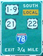
at the Newark Airport InterchangeNewark Airport InterchangeThe Newark Airport Interchange is a massive interchange of Interstate 78, U.S. Route 1/9, U.S. Route 22, Route 21, and Interstate 95 at the northern edge of Newark Airport in Newark, New Jersey.-Description:...
in Newark, New JerseyNewark, New JerseyNewark is the largest city in the American state of New Jersey, and the seat of Essex County. As of the 2010 United States Census, Newark had a population of 277,140, maintaining its status as the largest municipality in New Jersey. It is the 68th largest city in the U.S... - Interstate 278Interstate 278Interstate 278 is an auxiliary Interstate Highway in New Jersey and New York, United States. The road runs from U.S. Route 1/9 in Linden, New Jersey to the Bruckner Interchange in the New York City borough of the Bronx...
in Linden, New JerseyLinden, New Jersey- Local government :, the Mayor of Linden is . The former longtime Mayor of Linden is 82-year-old John T. Gregorio, who served as mayor of Linden for 30, nonconsecutive years and was repeatedly tagged with scandal during his mayoral career, including one felony conviction, later pardoned, which... - New Jersey TurnpikeNew Jersey TurnpikeThe New Jersey Turnpike is a toll road in New Jersey, maintained by the New Jersey Turnpike Authority. According to the International Bridge, Tunnel and Turnpike Association, the Turnpike is the nation's sixth-busiest toll road and is among one of the most heavily traveled highways in the United...
in Woodbridge, New Jersey - Garden State ParkwayGarden State ParkwayThe Garden State Parkway is a 172.4-mile limited-access toll parkway that stretches the length of New Jersey from the New York line at Montvale, New Jersey, to Cape May at New Jersey's southernmost tip. Its name refers to New Jersey's nickname, the "Garden State." Most New Jersey residents refer...
in Woodbridge, New Jersey - Garden State Parkway in Sayreville, New JerseySayreville, New JerseySayreville is a borough located on the Raritan River, near Raritan Bay in Middlesex County, New Jersey, United States. As of the 2010 United States Census, the borough population was 42,704....
- Interstate 195Interstate 195 (New Jersey)Interstate 195 is an auxiliary route of the Interstate Highway System located in the U.S. state of New Jersey. Its western end is at I-295 and Route 29 just south of Trenton, New Jersey in Hamilton Township, Mercer County while its eastern end is at the Garden State Parkway, Route 34 and Route...
in Howell, New Jersey - Garden State Parkway in Toms River, New JerseyToms River, New JerseyToms River is a census-designated place and unincorporated area located within Toms River Township and is the county seat of Ocean County, New Jersey. It is part of a larger Toms River Township...
. US 9 and the Garden State Parkway overlap between here and South Toms River, New JerseySouth Toms River, New JerseySouth Toms River is a Borough in Ocean County, New Jersey, United States. As of the United States 2010 Census, the borough population was 3,684....
. - Garden State Parkway near New Gretna, New JerseyNew Gretna, New JerseyNew Gretna is an unincorporated area within Bass River Township in Burlington County, New Jersey, United States. The area is served as United States Postal Service ZIP Code 08224....
. US 9 and the Garden State Parkway overlap between here and Port Republic, New JerseyPort Republic, New JerseyPort Republic is a city located in Atlantic County, New Jersey. As of the United States 2010 Census, the city had a total population of 1,115....
. - Atlantic City ExpresswayAtlantic City ExpresswayThe Atlantic City Expressway is a , controlled-access toll road in New Jersey, managed and operated by the South Jersey Transportation Authority...
in Pleasantville, New JerseyPleasantville, New Jersey-Local government:Pleasantville operates under the City form of New Jersey municipal government, led by a Mayor and a seven-member City Council. The City Council consists of two members elected from wards to three-year terms, and five members elected at-large to four-year terms in office, all of...
Bannered and suffixed routes
- U.S. Route 9WU.S. Route 9WU.S. Route 9W is a north–south U.S. Highway in the states of New Jersey and New York. It begins on Fletcher Avenue in Fort Lee, New Jersey as it crosses the US 1 & 9, US 46, and the Interstate 95 approaches to the George Washington Bridge, where it heads north up the west...
- U.S. Route 9 Alternate in Toms River, New JerseyToms River, New JerseyToms River is a census-designated place and unincorporated area located within Toms River Township and is the county seat of Ocean County, New Jersey. It is part of a larger Toms River Township...
- U.S. Route 1-9 TruckU.S. Route 1-9 Truck (Jersey City, New Jersey)U.S. Route 1/9 Truck is a United States highway in the northern part of New Jersey that stretches from the eastern edge of Newark to the Tonnelle Circle in Jersey City. It is the alternate road for U.S. Route 1/9 that trucks must use because they are prohibited from using the Pulaski Skyway, which...
in Jersey City, New JerseyJersey City, New JerseyJersey City is the seat of Hudson County, New Jersey, United States.Part of the New York metropolitan area, Jersey City lies between the Hudson River and Upper New York Bay across from Lower Manhattan and the Hackensack River and Newark Bay... - U.S. Route 1-9 Business in Jersey City, New Jersey
- U.S. Route 9 Truck in Georgetown, DelawareGeorgetown, DelawareGeorgetown is a town in Sussex County, Delaware, United States. According to 2010 census figures, the population of the town is 6,422, an increase of 38.3% over the previous decade...
- U.S. Route 9 Business in Lewes, DelawareLewes, DelawareLewes is an incorporated city in Sussex County, Delaware, USA, on the Delmarva Peninsula. According to the 2010 census, the population is 2,747, a decrease of 6.3% from 2000....
- U.S. Route 9 Bypass — NYS 9H in Hudson, New York
External links
- Delaware Highways - US 9
- NJDOT - US 9 Straight Line Diagram for the New Jersey portion of US9 from the New Jersey Department of TransportationNew Jersey Department of TransportationThe New Jersey Department of Transportation is the agency responsible for transportation issues and policy in New Jersey. It is headed by the Commissioner of Transportation...
- New Jersey Highways - US 9
- Capital Highways -- Mid-Crosstown Arterial