
.gif)
Route 109 (New Jersey)
Encyclopedia
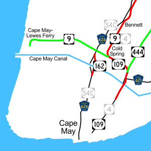
Route 109 is a 3.06 miles (4.92 km) state highway
located in Cape May County
, New Jersey
, United States
. The route runs from Jackson Street in Cape May
north to an intersection with U.S. Route 9 in Lower Township
. It crosses one of two road bridges over the Cape May Canal
(the other is Route 162
) and provides access to the southern end of the Garden State Parkway
and County Route 621 (Ocean Drive
) as well as to Cape May. Only the section of road in Lower Township is state maintained; the rest is maintained by Cape May County and signed as County Route 633, which extends 0.34 mi (0.5471756 km) past the southern terminus along Jackson Street and Perry Street to County Route 626 in West Cape May
.
Present-day Route 109 was designated as a part of pre-1927 Route 14 in 1917 before becoming the southernmost portion of Route 4 in 1927. By the 1940s, U.S. Route 9 extended south to Cape May from Absecon
along this part of Route 4. In 1953, the Route 4 designation was dropped from this segment of road to avoid the concurrency with U.S. Route 9. In the 1970s, U.S. Route 9 was rerouted to head to the Cape May – Lewes Ferry terminal and continue south to Laurel, Delaware
, with the former alignment into Cape May becoming Route 109.
, heading to the northeast on Lafayette Street, a two-lane undivided road that is county-maintained and signed as a part of County Route 633, which itself extends past the southern terminus of Route 109 along Jackson Street and Perry Street to County Route 626 in West Cape May
. The route passes through residential and commercial areas of Cape May, intersecting the northern terminus of County Route 653. At the intersection with Sidney Avenue, Route 109 splits into a one-way pair
that has two lanes in each direction, with the northbound direction following Sidney Avenue east before turning north on Washington Street
and the southbound direction remaining on Lafayette Street. Along this pairing, northbound Route 109 intersects the northern terminus of County Route 622. A short distance later, Washington Street turns west to join Lafayette Street, ending the one-way pair, and the route heads north as a two-lane undivided road.
It crosses a body of water onto an island in Lower Township
. Here, the route becomes maintained by the New Jersey Department of Transportation
and signed as Route 109, continuing north past several marinas and other resort businesses. The road briefly widens into a four-lane divided highway
before the median ends and it crosses over the Cape May Canal
on a bridge. Upon crossing the canal, Route 109 becomes a divided highway again and intersects County Route 621 (Ocean Drive
). From here, the road passes a mix of homes and businesses before intersecting the southern terminus of the Garden State Parkway
at an at-grade intersection. At this point, the route turns to the west and becomes a two-lane undivided road and heads through woods and marshland with some residences. Route 109 heads into residential neighborhoods before it ends at an intersection with U.S. Route 9, which continues north on the road past this intersection as well as west along Sandman Boulevard toward the Cape May-Lewes Ferry
terminal.
 The road that is now Route 109 was legislated as a part of pre-1927 Route 14 in 1917, a route that was to run from Cape May to Egg Harbor City
along what is now Route 109, U.S. Route 9 and Route 50. In the 1927 New Jersey state highway renumbering
, this portion of pre-1927 Route 14 became the southernmost part of Route 4, a route that was to run from Cape May north to the George Washington Bridge
. By the 1940s, U.S. Route 9 was extended south from Absecon
to Cape May, running concurrent with Route 4. In the 1953 New Jersey state highway renumbering
, which eliminated long concurrencies between U.S. and state routes, the Route 4 designation was dropped along this portion of road, leaving U.S. Route 9 as the sole designation. U.S. Route 9 was rerouted to the Cape May – Lewes Ferry and extended to U.S. Route 13
in Laurel, Delaware
, in the 1970s, with Route 109 designated along the former alignment of U.S. Route 9 into Cape May.
State highway
State highway, state road or state route can refer to one of three related concepts, two of them related to a state or provincial government in a country that is divided into states or provinces :#A...
located in Cape May County
Cape May County, New Jersey
-Climate:Being the southernmost point in New Jersey, Cape May has fairly mild wintertime temperatures. Contrary to that, the summertime has lower temperatures than most places in the state, making the county a popular place to escape the heat. It is in zone 7a/7b, which is the same as parts of...
, New Jersey
New Jersey
New Jersey is a state in the Northeastern and Middle Atlantic regions of the United States. , its population was 8,791,894. It is bordered on the north and east by the state of New York, on the southeast and south by the Atlantic Ocean, on the west by Pennsylvania and on the southwest by Delaware...
, United States
United States
The United States of America is a federal constitutional republic comprising fifty states and a federal district...
. The route runs from Jackson Street in Cape May
Cape May, New Jersey
Cape May is a city at the southern tip of Cape May Peninsula in Cape May County, New Jersey, where the Delaware Bay meets the Atlantic Ocean and is one of the country's oldest vacation resort destinations. It is part of the Ocean City Metropolitan Statistical Area. As of the 2010 United States...
north to an intersection with U.S. Route 9 in Lower Township
Lower Township, New Jersey
Lower Township is a township in Cape May County, New Jersey, United States. It is part of the Ocean City Metropolitan Statistical Area. As of the United States 2000 Census, the township population was 22,945....
. It crosses one of two road bridges over the Cape May Canal
Cape May Canal
The Cape May Canal is a waterway that stretches nearly three miles from Cape May Harbor to the Delaware Bay, at the southern tip of Cape May County, New Jersey. The canal was constructed by the United States Army Corps of Engineers during World War II to provide a protected route to avoid German...
(the other is Route 162
New Jersey Route 162
Route 162 is an unsigned long state highway in Lower Township, New Jersey, United States. The highway's designation consists entirely of a bridge on Seashore Road , which is known as Relocated Seashore Road. The southern terminus of the highway is an intersection with County Routes 641 and 626 in...
) and provides access to the southern end of the Garden State Parkway
Garden State Parkway
The Garden State Parkway is a 172.4-mile limited-access toll parkway that stretches the length of New Jersey from the New York line at Montvale, New Jersey, to Cape May at New Jersey's southernmost tip. Its name refers to New Jersey's nickname, the "Garden State." Most New Jersey residents refer...
and County Route 621 (Ocean Drive
Ocean Drive (New Jersey)
Ocean Drive is a series of local roads in southern New Jersey, connecting Atlantic City to Cape May along barrier islands on the Atlantic Ocean...
) as well as to Cape May. Only the section of road in Lower Township is state maintained; the rest is maintained by Cape May County and signed as County Route 633, which extends 0.34 mi (0.5471756 km) past the southern terminus along Jackson Street and Perry Street to County Route 626 in West Cape May
West Cape May, New Jersey
West Cape May is a Walsh Act borough in Cape May County, New Jersey, United States. It is part of the Ocean City Metropolitan Statistical Area. As of the United States 2000 Census, the borough population was 1,095....
.
Present-day Route 109 was designated as a part of pre-1927 Route 14 in 1917 before becoming the southernmost portion of Route 4 in 1927. By the 1940s, U.S. Route 9 extended south to Cape May from Absecon
Absecon, New Jersey
Absecon is a city in Atlantic County, New Jersey, United States. As of the 2010 United States Census, the city population was 8,411.What is now the City of Absecon was originally incorporated as a town by an Act of the New Jersey Legislature on February 29, 1872, from portions of Egg Harbor...
along this part of Route 4. In 1953, the Route 4 designation was dropped from this segment of road to avoid the concurrency with U.S. Route 9. In the 1970s, U.S. Route 9 was rerouted to head to the Cape May – Lewes Ferry terminal and continue south to Laurel, Delaware
Laurel, Delaware
As of the census of 2000, there were 3,668 people, 1,389 households, and 957 families residing in the town. The population density was 2,215.9 people per square mile . There were 1,561 housing units at an average density of 943.0 per square mile...
, with the former alignment into Cape May becoming Route 109.
Route description
Route 109 begins at an intersection with County Route 633 in Cape MayCape May, New Jersey
Cape May is a city at the southern tip of Cape May Peninsula in Cape May County, New Jersey, where the Delaware Bay meets the Atlantic Ocean and is one of the country's oldest vacation resort destinations. It is part of the Ocean City Metropolitan Statistical Area. As of the 2010 United States...
, heading to the northeast on Lafayette Street, a two-lane undivided road that is county-maintained and signed as a part of County Route 633, which itself extends past the southern terminus of Route 109 along Jackson Street and Perry Street to County Route 626 in West Cape May
West Cape May, New Jersey
West Cape May is a Walsh Act borough in Cape May County, New Jersey, United States. It is part of the Ocean City Metropolitan Statistical Area. As of the United States 2000 Census, the borough population was 1,095....
. The route passes through residential and commercial areas of Cape May, intersecting the northern terminus of County Route 653. At the intersection with Sidney Avenue, Route 109 splits into a one-way pair
One-way pair
A one-way pair, one-way couple, or just couplet is a pair of parallel, usually one-way streets that carry opposite directions of a signed route or major traffic flow, or sometimes opposite directions of a bus or streetcar route....
that has two lanes in each direction, with the northbound direction following Sidney Avenue east before turning north on Washington Street
Washington Street (Cape May)
Washington Street is the name of a major east-west street in downtown Cape May, New Jersey. It begins at Lafayette Street and ends at Ocean Street. Unofficially, there is a famous walkway, named the Washington Street Mall, between Ocean Street and Perry Street...
and the southbound direction remaining on Lafayette Street. Along this pairing, northbound Route 109 intersects the northern terminus of County Route 622. A short distance later, Washington Street turns west to join Lafayette Street, ending the one-way pair, and the route heads north as a two-lane undivided road.
It crosses a body of water onto an island in Lower Township
Lower Township, New Jersey
Lower Township is a township in Cape May County, New Jersey, United States. It is part of the Ocean City Metropolitan Statistical Area. As of the United States 2000 Census, the township population was 22,945....
. Here, the route becomes maintained by the New Jersey Department of Transportation
New Jersey Department of Transportation
The New Jersey Department of Transportation is the agency responsible for transportation issues and policy in New Jersey. It is headed by the Commissioner of Transportation...
and signed as Route 109, continuing north past several marinas and other resort businesses. The road briefly widens into a four-lane divided highway
Divided Highway
Divided Highway is a compilation album by American rock band The Doobie Brothers, released in 2003. . All tracks are taken from the albums Cycles and Brotherhood .-Track listing:...
before the median ends and it crosses over the Cape May Canal
Cape May Canal
The Cape May Canal is a waterway that stretches nearly three miles from Cape May Harbor to the Delaware Bay, at the southern tip of Cape May County, New Jersey. The canal was constructed by the United States Army Corps of Engineers during World War II to provide a protected route to avoid German...
on a bridge. Upon crossing the canal, Route 109 becomes a divided highway again and intersects County Route 621 (Ocean Drive
Ocean Drive (New Jersey)
Ocean Drive is a series of local roads in southern New Jersey, connecting Atlantic City to Cape May along barrier islands on the Atlantic Ocean...
). From here, the road passes a mix of homes and businesses before intersecting the southern terminus of the Garden State Parkway
Garden State Parkway
The Garden State Parkway is a 172.4-mile limited-access toll parkway that stretches the length of New Jersey from the New York line at Montvale, New Jersey, to Cape May at New Jersey's southernmost tip. Its name refers to New Jersey's nickname, the "Garden State." Most New Jersey residents refer...
at an at-grade intersection. At this point, the route turns to the west and becomes a two-lane undivided road and heads through woods and marshland with some residences. Route 109 heads into residential neighborhoods before it ends at an intersection with U.S. Route 9, which continues north on the road past this intersection as well as west along Sandman Boulevard toward the Cape May-Lewes Ferry
Cape May-Lewes Ferry
The Cape May – Lewes Ferry is a ferry system that traverses a 17-mile crossing of the Delaware Bay to connect Cape May, New Jersey with Lewes, Delaware. The ferry doubles as a section of U.S. Route 9.-The system:...
terminal.
History
Egg Harbor City, New Jersey
Egg Harbor City is a city in Atlantic County, New Jersey, United States. As of the 2010 United States Census, the city population was 4,243....
along what is now Route 109, U.S. Route 9 and Route 50. In the 1927 New Jersey state highway renumbering
1927 New Jersey state highway renumbering
In 1927, New Jersey's state highways were renumbered. The old system, which had been defined in sequence by the legislature, was growing badly, as several routes shared the same number, and many unnumbered state highways had been defined...
, this portion of pre-1927 Route 14 became the southernmost part of Route 4, a route that was to run from Cape May north to the George Washington Bridge
George Washington Bridge
The George Washington Bridge is a suspension bridge spanning the Hudson River, connecting the Washington Heights neighborhood in the borough of Manhattan in New York City to Fort Lee, Bergen County, New Jersey. Interstate 95 and U.S. Route 1/9 cross the river via the bridge. U.S...
. By the 1940s, U.S. Route 9 was extended south from Absecon
Absecon, New Jersey
Absecon is a city in Atlantic County, New Jersey, United States. As of the 2010 United States Census, the city population was 8,411.What is now the City of Absecon was originally incorporated as a town by an Act of the New Jersey Legislature on February 29, 1872, from portions of Egg Harbor...
to Cape May, running concurrent with Route 4. In the 1953 New Jersey state highway renumbering
1953 New Jersey state highway renumbering
On January 1, 1953, the New Jersey Department of Transportation renumbered many of the State Routes. A few rules were followed in deciding what to renumber:...
, which eliminated long concurrencies between U.S. and state routes, the Route 4 designation was dropped along this portion of road, leaving U.S. Route 9 as the sole designation. U.S. Route 9 was rerouted to the Cape May – Lewes Ferry and extended to U.S. Route 13
U.S. Route 13 in Delaware
U.S. Route 13 is the main north–south highway in the U.S. state of Delaware. It traverses the entire length of the state from the Maryland border in Delmar, Sussex County to the Pennsylvania border in Claymont, New Castle County. U.S. Route 13 connects many important cities and towns in...
in Laurel, Delaware
Laurel, Delaware
As of the census of 2000, there were 3,668 people, 1,389 households, and 957 families residing in the town. The population density was 2,215.9 people per square mile . There were 1,561 housing units at an average density of 943.0 per square mile...
, in the 1970s, with Route 109 designated along the former alignment of U.S. Route 9 into Cape May.