
New York State Route 306
Encyclopedia
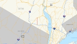
New York State Route 306 (NY 306) is a north–south state highway
in western Rockland County, New York
in the United States
. NY 306 runs from NY 59
in the hamlet of Monsey
to U.S. Route 202 (US 202) in Ladentown, on the western boundary of the village of Pomona
. The road is currently 5.33 miles (8.58 km) long; however, it originally extended south to the New Jersey
state line and north to Willow Grove Road (former NY 210
) when it was assigned as part of the 1930 renumbering of state highways in New York.
 NY 306 begins at NY 59
in the Ramapo
hamlet of Monsey
and proceeds north as Main Street through part of the business district of Monsey. After passing Maple Avenue in the Jewish village of Kaser
, NY 306 becomes Monsey-Ladentown Road for the rest of its run. NY 306 quickly leaves the small village and reenters the town of Ramapo.
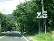
Roughly 1 miles (1.6 km) north of Kaser, NY 306 intersects County Route 74
(CR 74). Ramapo High School is located just east of NY 306 on CR 74. NY 306 then passes a fairly large cemetery called Church of the West Hempstead Cemetery. NY 306 continues north past CR 80
, and enters the village of Wesley Hills
. There it passes a small shopping center, and proceeds into residential areas. Finally, NY 306 enters Pomona
at CR 86. The route ends shortly afterward at US 202.
 When NY 306 was assigned as part of the 1930 renumbering of state highways in New York, it extended from the New Jersey
state line in the south to Willow Grove Road (then part of NY 210
) in the north via East Saddle River Road, Monsey-Ladentown Road, and Call Hollow Road. NY 306 was truncated to its current northern terminus at US 202 in Ramapo
(now part of the village of Pomona
) ca. 1939 and to its modern southern end at NY 59
in Monsey
ca. 1962. The former extensions of NY 306 are now largely maintained by Rockland County
as CR 73 (East Saddle River Road) and CR 75 (Call Hollow Road north of the Ramapo town line). The current southern terminus of NY 306 in Monsey was the proposed southwestern terminus of the Spring Valley Bypass, a bypass of NY 45
and NY 59 that was never built.
State highway
State highway, state road or state route can refer to one of three related concepts, two of them related to a state or provincial government in a country that is divided into states or provinces :#A...
in western Rockland County, New York
Rockland County, New York
Rockland County is a suburban county 15 miles to the northwest of Manhattan and part of the New York City Metropolitan Area, in the U.S. state of New York. It is the southernmost county in New York west of the Hudson River, and the smallest county in New York outside of New York City. The...
in the United States
United States
The United States of America is a federal constitutional republic comprising fifty states and a federal district...
. NY 306 runs from NY 59
New York State Route 59
New York State Route 59 is an east–west state highway in southern Rockland County, New York, in the United States. The route extends for from NY 17 in Hillburn to U.S. Route 9W in Nyack. In Suffern, it has a concurrency with US 202 for . NY 59 runs parallel to the New...
in the hamlet of Monsey
Monsey, New York
Monsey is a hamlet , in the Town of Ramapo, Rockland County, New York, United States located north of the state of New Jersey; east of Suffern; south of Airmont and west of Nanuet...
to U.S. Route 202 (US 202) in Ladentown, on the western boundary of the village of Pomona
Pomona, New York
Pomona is a village partly in the Town of Ramapo and partly in the Town of Haverstraw in Rockland County, New York, United States, located north of New Hempstead, east of Harriman State Park, north of Monsey and west of Mount Ivy. According to the 2010 Census, the population was 3,103, a 13 percent...
. The road is currently 5.33 miles (8.58 km) long; however, it originally extended south to the New Jersey
New Jersey
New Jersey is a state in the Northeastern and Middle Atlantic regions of the United States. , its population was 8,791,894. It is bordered on the north and east by the state of New York, on the southeast and south by the Atlantic Ocean, on the west by Pennsylvania and on the southwest by Delaware...
state line and north to Willow Grove Road (former NY 210
New York State Route 210
New York State Route 210 is a state highway in Orange County, New York, in the United States. It runs north from the New Jersey state line—where it continues south as Passaic County Route 511 —along the west shore of Greenwood Lake to the eponymous village of Greenwood Lake, where it...
) when it was assigned as part of the 1930 renumbering of state highways in New York.
Route description
New York State Route 59
New York State Route 59 is an east–west state highway in southern Rockland County, New York, in the United States. The route extends for from NY 17 in Hillburn to U.S. Route 9W in Nyack. In Suffern, it has a concurrency with US 202 for . NY 59 runs parallel to the New...
in the Ramapo
Ramapo, New York
Ramapo , formerly known as New Hempstead and then Hampstead, is a town in Rockland County, New York, United States located north of New Jersey; southeast of Orange County, New York; south of the Town of Haverstraw and west of the Town of Clarkstown and the Town of Orangetown...
hamlet of Monsey
Monsey, New York
Monsey is a hamlet , in the Town of Ramapo, Rockland County, New York, United States located north of the state of New Jersey; east of Suffern; south of Airmont and west of Nanuet...
and proceeds north as Main Street through part of the business district of Monsey. After passing Maple Avenue in the Jewish village of Kaser
Kaser, New York
Kaser is a village in the Town of Ramapo Rockland County, New York, United States located north of Monsey; east of Airmont; south of Viola and west of Spring Valley. As of the United States 2000 Census, the village population was 3,316....
, NY 306 becomes Monsey-Ladentown Road for the rest of its run. NY 306 quickly leaves the small village and reenters the town of Ramapo.
Roughly 1 miles (1.6 km) north of Kaser, NY 306 intersects County Route 74
County Route 74 (Rockland County, New York)
County Route 74 is a long west–east county route in the central part of Rockland County, New York. CR 74 begins at US 202 in Montebello, near Harriman State Park, and ends at CR 35A in New City. CR 74 is an alternate route to County Route 80, as it runs...
(CR 74). Ramapo High School is located just east of NY 306 on CR 74. NY 306 then passes a fairly large cemetery called Church of the West Hempstead Cemetery. NY 306 continues north past CR 80
County Route 80 (Rockland County, New York)
County Route 80 is a west–east county route in the central part of Rockland County, New York. CR 80 serves as an alternative route for NY 59 and the New York State Thruway . In fact, CR 80 is the only route besides those two major routes that runs completely from the...
, and enters the village of Wesley Hills
Wesley Hills, New York
Wesley Hills is a village in the Town of Ramapo, Rockland County, New York, United States located north of Viola; east of Harriman State Park; south of Pomona and west of New Hempstead...
. There it passes a small shopping center, and proceeds into residential areas. Finally, NY 306 enters Pomona
Pomona, New York
Pomona is a village partly in the Town of Ramapo and partly in the Town of Haverstraw in Rockland County, New York, United States, located north of New Hempstead, east of Harriman State Park, north of Monsey and west of Mount Ivy. According to the 2010 Census, the population was 3,103, a 13 percent...
at CR 86. The route ends shortly afterward at US 202.
History
New Jersey
New Jersey is a state in the Northeastern and Middle Atlantic regions of the United States. , its population was 8,791,894. It is bordered on the north and east by the state of New York, on the southeast and south by the Atlantic Ocean, on the west by Pennsylvania and on the southwest by Delaware...
state line in the south to Willow Grove Road (then part of NY 210
New York State Route 210
New York State Route 210 is a state highway in Orange County, New York, in the United States. It runs north from the New Jersey state line—where it continues south as Passaic County Route 511 —along the west shore of Greenwood Lake to the eponymous village of Greenwood Lake, where it...
) in the north via East Saddle River Road, Monsey-Ladentown Road, and Call Hollow Road. NY 306 was truncated to its current northern terminus at US 202 in Ramapo
Ramapo, New York
Ramapo , formerly known as New Hempstead and then Hampstead, is a town in Rockland County, New York, United States located north of New Jersey; southeast of Orange County, New York; south of the Town of Haverstraw and west of the Town of Clarkstown and the Town of Orangetown...
(now part of the village of Pomona
Pomona, New York
Pomona is a village partly in the Town of Ramapo and partly in the Town of Haverstraw in Rockland County, New York, United States, located north of New Hempstead, east of Harriman State Park, north of Monsey and west of Mount Ivy. According to the 2010 Census, the population was 3,103, a 13 percent...
) ca. 1939 and to its modern southern end at NY 59
New York State Route 59
New York State Route 59 is an east–west state highway in southern Rockland County, New York, in the United States. The route extends for from NY 17 in Hillburn to U.S. Route 9W in Nyack. In Suffern, it has a concurrency with US 202 for . NY 59 runs parallel to the New...
in Monsey
Monsey, New York
Monsey is a hamlet , in the Town of Ramapo, Rockland County, New York, United States located north of the state of New Jersey; east of Suffern; south of Airmont and west of Nanuet...
ca. 1962. The former extensions of NY 306 are now largely maintained by Rockland County
Rockland County, New York
Rockland County is a suburban county 15 miles to the northwest of Manhattan and part of the New York City Metropolitan Area, in the U.S. state of New York. It is the southernmost county in New York west of the Hudson River, and the smallest county in New York outside of New York City. The...
as CR 73 (East Saddle River Road) and CR 75 (Call Hollow Road north of the Ramapo town line). The current southern terminus of NY 306 in Monsey was the proposed southwestern terminus of the Spring Valley Bypass, a bypass of NY 45
New York State Route 45
New York State Route 45 is a north–south state highway in central Rockland County, New York, United States. It spans from the village of Chestnut Ridge at the New Jersey – New York border, where it becomes County Route 73 in Bergen County, New Jersey, to U.S. Route 202 in...
and NY 59 that was never built.