

Paint Branch
Encyclopedia
Stream
A stream is a body of water with a current, confined within a bed and stream banks. Depending on its locale or certain characteristics, a stream may be referred to as a branch, brook, beck, burn, creek, "crick", gill , kill, lick, rill, river, syke, bayou, rivulet, streamage, wash, run or...
that flows through Montgomery County
Montgomery County, Maryland
Montgomery County is a county in the U.S. state of Maryland, situated just to the north of Washington, D.C., and southwest of the city of Baltimore. It is one of the most affluent counties in the United States, and has the highest percentage of residents over 25 years of age who hold post-graduate...
and Prince George's County, Maryland
Maryland
Maryland is a U.S. state located in the Mid Atlantic region of the United States, bordering Virginia, West Virginia, and the District of Columbia to its south and west; Pennsylvania to its north; and Delaware to its east...
. It is a tributary
Tributary
A tributary or affluent is a stream or river that flows into a main stem river or a lake. A tributary does not flow directly into a sea or ocean...
of the Northeast Branch
Northeast Branch Anacostia River
Northeast Branch Anacostia River is a free-flowing stream in Prince George's County, Maryland. It is a tributary of the Anacostia River, which flows to the Potomac River and the Chesapeake Bay.-Course:...
, which flows to the Anacostia River
Anacostia River
The Anacostia River is a river in the Mid Atlantic region of the United States. It flows from Prince George's County in Maryland into Washington, D.C., where it joins with the Washington Channel to empty into the Potomac River at Buzzard Point. It is approximately long...
, Potomac River
Potomac River
The Potomac River flows into the Chesapeake Bay, located along the mid-Atlantic coast of the United States. The river is approximately long, with a drainage area of about 14,700 square miles...
and the Chesapeake Bay
Chesapeake Bay
The Chesapeake Bay is the largest estuary in the United States. It lies off the Atlantic Ocean, surrounded by Maryland and Virginia. The Chesapeake Bay's drainage basin covers in the District of Columbia and parts of six states: New York, Pennsylvania, Delaware, Maryland, Virginia, and West...
.
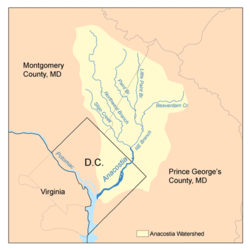
The headwaters of Paint Branch are located near Spencerville
Spencerville, Maryland
Spencerville is an unincorporated community in Montgomery County, Maryland, United States. Spencerville is north of Cloverly. Spencerville has a post office with ZIP code 20868....
(about 11.5 miles (18.5 km) north of Washington, D.C.
Washington, D.C.
Washington, D.C., formally the District of Columbia and commonly referred to as Washington, "the District", or simply D.C., is the capital of the United States. On July 16, 1790, the United States Congress approved the creation of a permanent national capital as permitted by the U.S. Constitution....
) and the stream flows south for 14 miles (22.5 km) to its confluence
Confluence
Confluence, in geography, describes the meeting of two or more bodies of water.Confluence may also refer to:* Confluence , a property of term rewriting systems...
with the Northeast Branch. The watershed
Drainage basin
A drainage basin is an extent or an area of land where surface water from rain and melting snow or ice converges to a single point, usually the exit of the basin, where the waters join another waterbody, such as a river, lake, reservoir, estuary, wetland, sea, or ocean...
area is 20.8 square miles (53.9 km²) and includes portions of the communities of Spencerville, Cloverly
Cloverly, Maryland
Cloverly is a census-designated place and an unincorporated town in Montgomery County, Maryland, United States.-Geography:As an unincorporated area, Cloverly's boundaries are not officially defined. Many residents consider themselves to live in a neighborhood of Silver Spring, Maryland, the...
, Fairland
Fairland, Maryland
Fairland is a census-designated place and an unincorporated area in Montgomery County, Maryland, United States.-Geography:As an unincorporated area, Fairland's boundaries are not officially defined...
, Colesville
Colesville, Maryland
Colesville is a census-designated place and an unincorporated area in Montgomery County, Maryland in the USA.-Geography:As an unincorporated area, Colesville's boundaries are not officially defined. Also, many residents consider the town to be one of the many neighborhoods of Silver Spring, Maryland...
, White Oak
White Oak, Maryland
White Oak is a census-designated place and an unincorporated area in Montgomery County, Maryland, United States.-Geography:As an unincorporated area, White Oak's boundaries are not officially defined...
and College Park
College Park, Maryland
College Park is a city in Prince George's County, Maryland, USA. The population was 30,413 at the 2010 census. It is best known as the home of the University of Maryland, College Park, and since 1994 the city has also been home to the "Archives II" facility of the U.S...
.
Tributaries
- Left Fork
- Right Fork
- Gum Springs Tributary
- Good Hope Tributary
- Snowden's Mill Branch
- Fairland Farms
- Columbia Park Tributary
- Hollywood Branch
- Martin Luther King Tributary
- Tanley Road Tributary
- Stewart-April Lane Tributary
- West Farm Branch
- Little Paint Branch
- Indian Creek
External links
- Eyes of Paint Branch Community watershed organization
- Countywide Stream Protection Strategy: Paint Branch Watershed Montgomery County Dept. of Environmental Protection
- Anacostia Watershed Society
- Anacostia Watershed Restoration Partnership
- Paint Branch Trail Montgomery County Dept. of Parks
- Anacostia Tributary Trail System Prince George's County Dept. of Parks & Recreation