
Santee, South Carolina
Encyclopedia
Santee is a town in Orangeburg County along the Santee River
Valley
in central South Carolina
of the United States
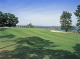
. It has become a resort town of note located centrally north-south along the Atlantic Seaboard of South Carolina. The region has been rural, with a primarily agricultural economy typical of Orangeburg County, but it is now known primarily for its several golf course
s in proximity to Lake Marion
, Santee State Park
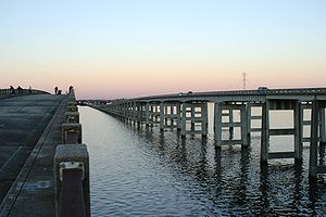
and other Lake Marion attractions. Interstate 95
connects its attractions easily with tourists' traveling by automobile
. I95
crosses a narrow arm of the lake into the town lands, along a picturesque causeway (see photo at right). Lake Marion is a man-made hydroelectric reservoir, which at 110,000 acres (450 km2, 173 sq mi) is one of the fifty largest lakes in the country.
The population was only 740 at the 2000 census. The town has been undergoing economic and population growth, and development as rural niches are supplanted by bedroom communities.
Construction of the Santee Cooper Regional Water System
can provide millions of gallons of potable water per day to the surrounding five counties centered about Santee. The system was coordinated by the U.S. Department of Agriculture and funded by the Army Corps of Engineers, USEPA, and the South Carolina Department of Commerce. The plant was completed and operational as of 1 June 2008. Work to connect the plant to the five counties (Berkeley, Orangeburg, Dorchester, Calhoun, and Sumter) is underway and being overseen and funded by the same parties. Currently the RWS serves the town of Santee, with pipeline rapidly being installed to other locations. Incoming businesses from this project are projected to bring thousands of jobs to the area. http://www.gulfretail.com/retail-property/dubai-firm-to-build-us-business-park-2.html
According to the United States Census Bureau
, the town has a total area of 2.0 square miles (5.3 km²), of which, 2.0 square miles (5.2 km²) of it is land and 0.49% is water.
of 2000, there were 740 people, 310 households, and 221 families residing in the town. The population density
was 367.4 people per square mile (142.1/km²). There were 394 housing units at an average density of 195.6 per square mile (75.7/km²). The racial makeup of the town was 28.11% White, 70.68% African American, 0.14% Asian, 0.54% from other races
, and 0.54% from two or more races. Hispanic or Latino of any race were 0.81% of the population.
There were 310 households out of which 27.4% had children under the age of 18 living with them, 41.0% were married couples
living together, 26.8% had a female householder with no husband present, and 28.7% were non-families. 26.5% of all households were made up of individuals and 14.2% had someone living alone who was 65 years of age or older. The average household size was 2.39 and the average family size was 2.85.
In the town the population was spread out with 25.3% under the age of 18, 10.4% from 18 to 24, 20.4% from 25 to 44, 18.8% from 45 to 64, and 25.1% who were 65 years of age or older. The median age was 39 years. For every 100 females there were 73.7 males. For every 100 females age 18 and over, there were 66.6 males.
The median income for a household in the town was $22,292, and the median income for a family was $28,393. Males had a median income of $27,083 versus $16,650 for females. The per capita income
for the town was $15,353. About 27.5% of families and 32.9% of the population were below the poverty line, including 46.1% of those under age 18 and 17.8% of those age 65 or over.
Santee River
The Santee River is a river in South Carolina in the United States, long. The Santee and its tributaries provide the principal drainage and navigation for the central coastal plain of South Carolina, emptying into the Atlantic Ocean approximately from its farthest headwater on the Catawba River...
Valley
River Valley
River Valley is the name of an urban planning area within the Central Area, Singapore's central business district.The River Valley Planning Area is defined by the region bounded by Orchard Boulevard, Devonshire Road and Eber Road to the north, Oxley Rise and Mohamed Sultan Road to the east, Martin...
in central South Carolina
South Carolina
South Carolina is a state in the Deep South of the United States that borders Georgia to the south, North Carolina to the north, and the Atlantic Ocean to the east. Originally part of the Province of Carolina, the Province of South Carolina was one of the 13 colonies that declared independence...
of the United States
United States
The United States of America is a federal constitutional republic comprising fifty states and a federal district...
. It has become a resort town of note located centrally north-south along the Atlantic Seaboard of South Carolina. The region has been rural, with a primarily agricultural economy typical of Orangeburg County, but it is now known primarily for its several golf course
Golf course
A golf course comprises a series of holes, each consisting of a teeing ground, fairway, rough and other hazards, and a green with a flagstick and cup, all designed for the game of golf. A standard round of golf consists of playing 18 holes, thus most golf courses have this number of holes...
s in proximity to Lake Marion
Lake Marion (South Carolina)
Lake Marion is the largest lake in South Carolina, centrally located and with territory within five counties. The lake is referred to as South Carolina's inland sea. It has a shoreline and covers nearly 110,000 acres of rolling farmlands, former marshes, and river valley landscape...
, Santee State Park
Santee State Park
Santee State Park is in the Sandhills of South Carolina on the western edge of the Lake Marion. It is located off SC 6, three miles northwest of the town of Santee and I-95....
and other Lake Marion attractions. Interstate 95
Interstate 95
Interstate 95 is the main highway on the East Coast of the United States, running parallel to the Atlantic Ocean from Maine to Florida and serving some of the most populated urban areas in the country, including Boston, Providence, New Haven, New York City, Newark, Philadelphia, Baltimore,...
connects its attractions easily with tourists' traveling by automobile
Automobile
An automobile, autocar, motor car or car is a wheeled motor vehicle used for transporting passengers, which also carries its own engine or motor...
. I95
Interstate 95
Interstate 95 is the main highway on the East Coast of the United States, running parallel to the Atlantic Ocean from Maine to Florida and serving some of the most populated urban areas in the country, including Boston, Providence, New Haven, New York City, Newark, Philadelphia, Baltimore,...
crosses a narrow arm of the lake into the town lands, along a picturesque causeway (see photo at right). Lake Marion is a man-made hydroelectric reservoir, which at 110,000 acres (450 km2, 173 sq mi) is one of the fifty largest lakes in the country.
The population was only 740 at the 2000 census. The town has been undergoing economic and population growth, and development as rural niches are supplanted by bedroom communities.
Construction of the Santee Cooper Regional Water System
Santee Cooper
Santee Cooper, also known officially from the 1930s as the South Carolina Public Service Authority, is South Carolina's state-owned electric and water utility that came into being during the New Deal as both a rural electrification and public works project that created two lakes and cleared large...
can provide millions of gallons of potable water per day to the surrounding five counties centered about Santee. The system was coordinated by the U.S. Department of Agriculture and funded by the Army Corps of Engineers, USEPA, and the South Carolina Department of Commerce. The plant was completed and operational as of 1 June 2008. Work to connect the plant to the five counties (Berkeley, Orangeburg, Dorchester, Calhoun, and Sumter) is underway and being overseen and funded by the same parties. Currently the RWS serves the town of Santee, with pipeline rapidly being installed to other locations. Incoming businesses from this project are projected to bring thousands of jobs to the area. http://www.gulfretail.com/retail-property/dubai-firm-to-build-us-business-park-2.html
Geography
Santee is located at 33°29′N 80°29′W (33.4784, -80.4846).According to the United States Census Bureau
United States Census Bureau
The United States Census Bureau is the government agency that is responsible for the United States Census. It also gathers other national demographic and economic data...
, the town has a total area of 2.0 square miles (5.3 km²), of which, 2.0 square miles (5.2 km²) of it is land and 0.49% is water.
Demographics
As of the censusCensus
A census is the procedure of systematically acquiring and recording information about the members of a given population. It is a regularly occurring and official count of a particular population. The term is used mostly in connection with national population and housing censuses; other common...
of 2000, there were 740 people, 310 households, and 221 families residing in the town. The population density
Population density
Population density is a measurement of population per unit area or unit volume. It is frequently applied to living organisms, and particularly to humans...
was 367.4 people per square mile (142.1/km²). There were 394 housing units at an average density of 195.6 per square mile (75.7/km²). The racial makeup of the town was 28.11% White, 70.68% African American, 0.14% Asian, 0.54% from other races
Race (United States Census)
Race and ethnicity in the United States Census, as defined by the Federal Office of Management and Budget and the United States Census Bureau, are self-identification data items in which residents choose the race or races with which they most closely identify, and indicate whether or not they are...
, and 0.54% from two or more races. Hispanic or Latino of any race were 0.81% of the population.
There were 310 households out of which 27.4% had children under the age of 18 living with them, 41.0% were married couples
Marriage
Marriage is a social union or legal contract between people that creates kinship. It is an institution in which interpersonal relationships, usually intimate and sexual, are acknowledged in a variety of ways, depending on the culture or subculture in which it is found...
living together, 26.8% had a female householder with no husband present, and 28.7% were non-families. 26.5% of all households were made up of individuals and 14.2% had someone living alone who was 65 years of age or older. The average household size was 2.39 and the average family size was 2.85.
In the town the population was spread out with 25.3% under the age of 18, 10.4% from 18 to 24, 20.4% from 25 to 44, 18.8% from 45 to 64, and 25.1% who were 65 years of age or older. The median age was 39 years. For every 100 females there were 73.7 males. For every 100 females age 18 and over, there were 66.6 males.
The median income for a household in the town was $22,292, and the median income for a family was $28,393. Males had a median income of $27,083 versus $16,650 for females. The per capita income
Per capita income
Per capita income or income per person is a measure of mean income within an economic aggregate, such as a country or city. It is calculated by taking a measure of all sources of income in the aggregate and dividing it by the total population...
for the town was $15,353. About 27.5% of families and 32.9% of the population were below the poverty line, including 46.1% of those under age 18 and 17.8% of those age 65 or over.