
Typhoon Pongsona
Encyclopedia
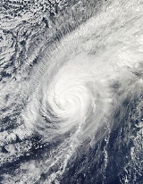
Typhoon Pongsona was the last typhoon
of the 2002 Pacific typhoon season
, and was the costliest United States disaster in 2002. The name "Pongsona" was contributed by North Korea
for the Pacific tropical cyclone list and is the Korean
name for the garden balsam
. Pongsona developed out of an area of disturbed weather on December 2, and steadily intensified to reach typhoon status on December 5. On December 8 it passed through Guam
and the Northern Marianas Islands while near its peak winds of 175 km/h (110 mph 10-min
). It ultimately turned to the northeast, weakened, and became extratropical on December 11.
Typhoon Pongsona produced strong wind gusts peaking at 278 km/h (173 mph 1-min), which left the entire island of Guam
without power and destroyed about 1,300 houses. With strong building standards and experience from repeated typhoon strikes, there were no fatalities directly related to Pongsona, although there was one indirect death from flying glass. Damage on the island totaled over $700 million (2002 USD
, $ USD), making Pongsona among the five costliest typhoons on the island. The typhoon also caused heavy damage on Rota
and elsewhere in the Northern Marianas Islands, and as a result of its impact the name was retired.
persisted about 625 kilometers (390 mi) east-southeast of Pohnpei
. Satellite imagery indicated broad cyclonic turning in the lower levels of the atmosphere, and a trough
was located near the surface. With beneficial outflow
aloft, the disturbance developed rainbands as deep convection increased near its mid-level circulation. A low-level circulation formed on December 1, which was initially weak, elongated, and slightly removed from the deep convection. Weak to moderate vertical wind shear
allowed the low-level circulation center to consolidate near its cycling convection. Based on its organization, the Japan Meteorological Agency
(JMA) classified the system a tropical depression at 0600 UTC on December 2 while it was located 735 km (450 mi) east-northeast of Pohnpei. Shortly thereafter, the Joint Typhoon Warning Center
(JTWC) issued a Tropical Cyclone Formation Alert
, and at 1800 UTC on December 2 the JTWC classified the system as Tropical Depression 31W.
Upon first becoming a tropical cyclone, the depression tracked northwestward, and in the hours after being classified the circulation became exposed to the east of the deepest convection due to wind shear. The JTWC upgraded the depression to tropical storm status early on December 3, and subsequent to a decrease in the shear the convection redeveloped over the circulation. Accordingly, the JMA upgraded the depression to Tropical Storm Pongsona at 1200 UTC on December 3 while located 375 km (230 mi) northeast of Pohnpei. Located to the south of an upper-level ridge
, Pongsona turned westward and gradually intensified. On December 5, the storm developed tightly curved banding features and began forming an eyewall
; both the JTWC and the JMA upgraded Pongsona to a typhoon while centered about 1150 km (715 mi) southeast of Guam
.
.jpg) A developing baroclinic system
A developing baroclinic system
to the east of Japan weakened the subtropical ridge, allowing Typhoon Pongsona to turn to the northwest. Its eye became better defined, and the cyclone continued to gradually intensify. By late on December 7 it developed a well-defined 55 km (35 mi) wide eye as it approached Guam, and the next day the JTWC assessed Pongsona as a 240 km/h (150 mph 1-min winds) supertyphoon
, its peak intensity. At 0500 UTC on December 8 the eyewall made landfall on Guam
. Shortly thereafter, the JMA estimated Pongsona attained a peak intensity of 175 km/h (110 mph 10-min winds) just to the north of Guam. The typhoon turned to the north-northwest through a weakness in the subtropical ridge a short distance west of the Northern Marianas Islands. On December 9, convection began to weaken as Pongsona began interacting with a mid-latitude system to its north. Dry air became entrained in the north and western portion of the circulation; the eyewall steadily deteriorated, and the low-level circulation became exposed to the west of the diminishing convection. As a result, both the JTWC and the JMA declared Pongsona as an extratropical cyclone
on December 11 about 1400 km (865 mi) northwest of Wake Island
.
uses 10-minute sustained winds, while the Joint Typhoon Warning Center
uses 1-minute sustained winds. The conversion factor between the two is 1.14. JMA's peak intensity for Pongsona was 170 km/h (105 mph) 10-minute sustained, or 195 km/h (120 mph) 1-minute sustained. The JTWC's peak intensity for Pongsona was 240 km/h (150 mph) 1-minute sustained, or 210 km/h (130 mph) 10-minute sustained. The National Meteorological Center of China estimated a peak intensity of 185 km/h (115 mph) 10-minute sustained, or 210 km/h (135 mph) 1-minute sustained.
National Weather Service
office issued a tropical storm watch
for the Marshall Islands
shortly after Pongsona developed into a tropical storm, and a day later watches were issued for Chuuk
. On December 5, the service issued tropical storm warnings for parts of the Federal States of Micronesia. As Pongsona became a typhoon, the Guam National Weather Service office issued a typhoon watch for Guam, Rota
, Saipan
, and Tinian
, which was upgraded to a typhoon warning about 23 hours prior to the onset of tropical storm-force winds; typhoon warnings were also issued for the unpopulated island of Agrihan
. By one day before the typhoon moved through the Mariana Islands
, JTWC predicted Pongsona to pass well east of the area. Despite a more westward track than anticipated, forecasts remained stagnant until the morning of December 8, when forecasters reluctantly predicted much greater threat to the Mariana Islands. As a result, many citizens felt they were unprepared and insufficiently warned for the typhoon.
Nine shelters throughout the Northern Mariana Islands were opened to accommodate families needing assistance. Several schools opened classrooms as evacuation centers. On Guam, ten schools were used as shelters, and on the day of impact 2,271 people were in shelters. On Rota, 159 people sought shelter, and in Saipan, 549 were in shelters by the day of impact. The Guam Memorial Hospital officials advised all pregnant women within 32 weeks of their delivery date to check in. The Guam Office of Civil Defense filed the paperwork for the Federal Emergency Management Agency
to declare the island a disaster area. Governor Carl T.C. Gutierrez
took similar measures to declare a state of emergency for the area. Following experience from previous typhoons, Guam newspaper Pacific Daily News
underwent preparations to provide internet updates for the storm, including reinforcing the building, maintaining sufficient food supplies for the staff, and stationing two reporters elsewhere on the island; the paper was the only immediate source of information about the typhoon outside of Guam.
as a tropical storm. There, it produced heavy rains and gusty winds, though little damage was reported. Later, it brought tropical storm force winds to Chuuk
. High waves from the storm washed over and covered some atolls.
 Typhoon Pongsona maintained a 65 km (40 mi) wide eye
upon crossing the northern portion of the island of Guam
; the Andersen Air Force Base
was in the eye for two hours. Sustained winds from the typhoon peaked at 232 km/h (144 mph) with gusts peaking at 278 km/h (173 mph); gusts of at least 160 km/h (100 mph) affected the entire island. The lowest pressure on the island was 935 millibars
(27.61 inHg
), making Pongsona the third most intense typhoon to strike Guam; it is behind only a typhoon in 1900 (926 mbar, 27.34 inHg) and Typhoon Karen of 1962 (932 mbar, 27.52 inHg).
Communications on the island failed due to the winds; the entire island was left without power and phone service. The winds greatly damaged 715 power poles and 513 transformers, leaving about $52 million in electrical damage reported (2002 USD, $ USD). The local weather office's communication link was cut off after flooding damaged a telecommunication facility, causing the National Weather Service in Honolulu, Hawaii
to provide backup support by temporarily issuing warnings and advisories. Many anemometers near the northern coastline failed from the winds. The winds collapsed several walls at the Guam Memorial Hospital, resulting in major damage throughout the northern two-thirds of the facility and several units being shut down. Several hotels, churches, and schools received moderate damage, and the Antonio B. Won Pat International Airport
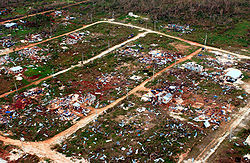
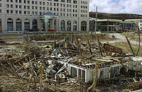
received damage to navigation equipment. Typhoon Pongsona also left 65% of the island's water wells inoperable, with most of Guam left without water service following the storm. Officials estimate the typhoon destroyed 1,300 homes, severely damaged 1,825, and lightly damaged 4,800.
 Tracking slowly across the center of the island, the intense inner rainbands dropped heavy rainfall which peaked at 650 mm (25.61 in) at the University of Guam
. The precipitation led to record river flow on the Pago and Asan Rivers; overflown rivers caused damage to some roads and bridges. The rainfall also caused extensive flooding in several villages. Pongsona produced a storm surge
of up to 6 m (20 ft) at some locations, with 3– 4 m (9– 13 ft) recorded near the eyewall. Considerable storm surge flooding occurred from Tumon
southward to Piti
, leaving some buildings on the west coast of the island flooded with 1 m (4 ft) of water. The combination of strong storm surge and rough waves caused considerable beach erosion and severe coastal damage.
Across Guam, damage totaled over $700 million (2002 USD, $ USD), placing it among the five costliest typhoons on the island. The typhoon injured 193 people, as reported by the Guam Department of Health; most were lacerations and fractures caused by flying glass and other debris. There was one indirect death attributed to the storm, when a 71-year old woman was cut by flying glass and subsequently suffered a fatal heart attack; medical help could not reach her due to the intensity of the storm. As six typhoons had passed directly over the island during the previous ten years, officials in Guam enacted strong building standards, keeping deaths and injuries to a minimum. The typhoon was considered by the public the worst typhoon to ever strike the island due to the large eye affecting most of the population.
. The combination of winds and other effects from the typhoon destroyed 114 houses, severely damaged 154, and caused minor damage to 306; on the island, about 200 families were left homeless. The typhoon produced a storm surge
of 6.7 m (22 ft) at Songsong Village
, which crossed about 80% of the southwestern peninsula on Rota. The surge caused moderate beach erosion on the island, and destroyed a fuel pier and a loading pipeline. Additionally, the typhoon caused severe crop damage on the island. In all, the typhoon caused ten minor injuries on Rota, and resulted in over $30 million in damage (2002 USD, $ USD).
On Tinian
, the passage of Pongsona destroyed two homes; seven received major damage and another eight sustained minor damage. The winds damaged power lines, causing two island-wide power outages. Major crop damage was reported.
On Saipan
, two houses were destroyed and fifteen were damaged, of which seven severely. Sustained winds on the island peaked at 71 km/h (44 mph), which caused scattered power outages. Six minor injuries were reported, and damage totaled about $100,000 (2002 USD, $ USD).
 On the same day of Typhoon Pongsona striking Guam
, President
George W. Bush
declared the island a major disaster area. Around the time of the cyclone passing over the island, 2,271 residents were in shelters, and by the next day it increased to 3,467 after people discovered their homes were uninhabitable. With thirteen Red Cross
shelters across Guam, most remained in shelters for about three weeks before disaster tents were distributed. The American Red Cross worked with the United States Department of Agriculture
to provide meals for shelter attendees for a two week period following the typhoon. Through the collaboration of federal and other agencies, disaster assistance on Guam totaled over $300 million (2003 USD, $335 million 2007 USD) by 100 days after the typhoon struck, including $60 million (2002 USD, $ USD) in initial disaster response. Nearly 29,000 individuals registered for disaster assistance, with the first assistance check arrived ten days after the disaster declaration. By three months after the storm, the United States Small Business Administration
approved $130 million (2003 USD, $ USD) in low-interest loans.
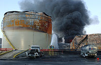
During the height of the typhoon at Cabras Island
on Guam, a gasoline tank caught fire, believed to be from friction caused by extremely high winds running through its ventilation system. The tank exploded, sending its lid airborne and spreading the fire to other nearby tanks. The proximity of the tanks as well as low water pressure hampered firefighting efforts, and the fire was extinguished five days later; it resulted in three destroyed gasoline tanks with two more caught on fire. While the fire was burning, transportation of gasoline from the port to the rest of Guam was suspended resulting in a halt in gasoline sales for the general public.
On December 11, 2002, President Bush extended the disaster declaration to include the Northern Marianas Islands, which allocated emergency disaster aid for the territory. The declaration provided funding for 75% of the budget for debris removal and emergency protective measures. Immediately following the typhoon, FEMA assigned various federal agencies to respond to the island of Rota. Officials airlifted about 3,600 kg (8,000 lbs) of emergency supplies including tents, tarps, water containers, coolers, cooking kits and electrical equipment. Military personnel were transported to assist in recovery efforts. By four months after the typhoon, 749 individuals on the island registered through FEMA's teleregistration number. The United States Small Business Administration
approved 147 low– interest loans for $9.1 million (2003 USD, $ USD) to individuals and businesses and for economic injury on Rota. In all, disaster aid to Rota totaled $17.4 million (2003 USD, $. Additionally, President Bush authorized disaster assistance for the Federated States of Micronesia
.
Due to the damage resulted from the storm, the name Pongsona was retired during the 38th session of the Economic and Social Commission for Asia and the Pacific and World Meteorological Organization
typhoon committee in November 2005; it was replaced with the name Noul.
Tropical cyclone
A tropical cyclone is a storm system characterized by a large low-pressure center and numerous thunderstorms that produce strong winds and heavy rain. Tropical cyclones strengthen when water evaporated from the ocean is released as the saturated air rises, resulting in condensation of water vapor...
of the 2002 Pacific typhoon season
2002 Pacific typhoon season
A Tropical Cyclone Formation Alert was issued on July 19 for a Tropical Disturbance that was located east of the international Date Line. The Next day the Disturbance crossed the international date line and was classified as a Tropical Depression by the JMA. The JMA then upgraded the depression to...
, and was the costliest United States disaster in 2002. The name "Pongsona" was contributed by North Korea
North Korea
The Democratic People’s Republic of Korea , , is a country in East Asia, occupying the northern half of the Korean Peninsula. Its capital and largest city is Pyongyang. The Korean Demilitarized Zone serves as the buffer zone between North Korea and South Korea...
for the Pacific tropical cyclone list and is the Korean
Korean language
Korean is the official language of the country Korea, in both South and North. It is also one of the two official languages in the Yanbian Korean Autonomous Prefecture in People's Republic of China. There are about 78 million Korean speakers worldwide. In the 15th century, a national writing...
name for the garden balsam
Impatiens balsamina
Impatiens balsamina is a species of Impatiens native to southern Asia in India and Myanmar.It is called kamantigue in the Philippines. This species of Kalamantigue are used in teas...
. Pongsona developed out of an area of disturbed weather on December 2, and steadily intensified to reach typhoon status on December 5. On December 8 it passed through Guam
Guam
Guam is an organized, unincorporated territory of the United States located in the western Pacific Ocean. It is one of five U.S. territories with an established civilian government. Guam is listed as one of 16 Non-Self-Governing Territories by the Special Committee on Decolonization of the United...
and the Northern Marianas Islands while near its peak winds of 175 km/h (110 mph 10-min
Minute
A minute is a unit of measurement of time or of angle. The minute is a unit of time equal to 1/60th of an hour or 60 seconds. In the UTC time scale, a minute on rare occasions has 59 or 61 seconds; see leap second. The minute is not an SI unit; however, it is accepted for use with SI units...
). It ultimately turned to the northeast, weakened, and became extratropical on December 11.
Typhoon Pongsona produced strong wind gusts peaking at 278 km/h (173 mph 1-min), which left the entire island of Guam
Guam
Guam is an organized, unincorporated territory of the United States located in the western Pacific Ocean. It is one of five U.S. territories with an established civilian government. Guam is listed as one of 16 Non-Self-Governing Territories by the Special Committee on Decolonization of the United...
without power and destroyed about 1,300 houses. With strong building standards and experience from repeated typhoon strikes, there were no fatalities directly related to Pongsona, although there was one indirect death from flying glass. Damage on the island totaled over $700 million (2002 USD
United States dollar
The United States dollar , also referred to as the American dollar, is the official currency of the United States of America. It is divided into 100 smaller units called cents or pennies....
, $ USD), making Pongsona among the five costliest typhoons on the island. The typhoon also caused heavy damage on Rota
Rota (island)
Rota also known as the "peaceful island", is the southernmost island of the United States Commonwealth of the Northern Mariana Islands and the second southernmost of the Marianas Archipelago. It lies approximately 40 miles north-northeast of the United States territory of Guam...
and elsewhere in the Northern Marianas Islands, and as a result of its impact the name was retired.
Meteorological history
During late November, an area of convectionConvection
Convection is the movement of molecules within fluids and rheids. It cannot take place in solids, since neither bulk current flows nor significant diffusion can take place in solids....
persisted about 625 kilometers (390 mi) east-southeast of Pohnpei
Pohnpei
Not to be confused with Pompeii, the ancient city destroyed by Vesuvius in AD 79.Pohnpei "upon a stone altar " is the name of one of the four states in the Federated States of Micronesia , situated among the Senyavin Islands which are part of the larger Caroline Islands group...
. Satellite imagery indicated broad cyclonic turning in the lower levels of the atmosphere, and a trough
Trough (meteorology)
A trough is an elongated region of relatively low atmospheric pressure, often associated with fronts.Unlike fronts, there is not a universal symbol for a trough on a weather chart. The weather charts in some countries or regions mark troughs by a line. In the United States, a trough may be marked...
was located near the surface. With beneficial outflow
Outflow (meteorology)
Outflow, in meteorology, is air that flows outwards from a storm system. It is associated with ridging, or anticyclonic flow. In the low levels of the troposphere, outflow radiates from thunderstorms in the form of a wedge of rain-cooled air, which is visible as a thin rope-like cloud on weather...
aloft, the disturbance developed rainbands as deep convection increased near its mid-level circulation. A low-level circulation formed on December 1, which was initially weak, elongated, and slightly removed from the deep convection. Weak to moderate vertical wind shear
Wind shear
Wind shear, sometimes referred to as windshear or wind gradient, is a difference in wind speed and direction over a relatively short distance in the atmosphere...
allowed the low-level circulation center to consolidate near its cycling convection. Based on its organization, the Japan Meteorological Agency
Japan Meteorological Agency
The or JMA, is the Japanese government's weather service. Charged with gathering and reporting weather data and forecasts in Japan, it is a semi-autonomous part of the Ministry of Land, Infrastructure and Transport...
(JMA) classified the system a tropical depression at 0600 UTC on December 2 while it was located 735 km (450 mi) east-northeast of Pohnpei. Shortly thereafter, the Joint Typhoon Warning Center
Joint Typhoon Warning Center
The Joint Typhoon Warning Center is a joint United States Navy – United States Air Force task force located at the Naval Maritime Forecast Center in Pearl Harbor, Hawaii...
(JTWC) issued a Tropical Cyclone Formation Alert
Tropical Cyclone Formation Alert
A Tropical Cyclone Formation Alert is a bulletin released by the U.S. Navy-operated Joint Typhoon Warning Center in Honolulu, Hawaii or the Naval Maritime Forecast Center in Norfolk, Virginia, warning of the possibility of a tropical cyclone forming from a tropical disturbance that has been...
, and at 1800 UTC on December 2 the JTWC classified the system as Tropical Depression 31W.
Upon first becoming a tropical cyclone, the depression tracked northwestward, and in the hours after being classified the circulation became exposed to the east of the deepest convection due to wind shear. The JTWC upgraded the depression to tropical storm status early on December 3, and subsequent to a decrease in the shear the convection redeveloped over the circulation. Accordingly, the JMA upgraded the depression to Tropical Storm Pongsona at 1200 UTC on December 3 while located 375 km (230 mi) northeast of Pohnpei. Located to the south of an upper-level ridge
Ridge (meteorology)
A ridge is an elongated region of relatively high atmospheric pressure, the opposite of a trough....
, Pongsona turned westward and gradually intensified. On December 5, the storm developed tightly curved banding features and began forming an eyewall
Eye (cyclone)
The eye is a region of mostly calm weather found at the center of strong tropical cyclones. The eye of a storm is a roughly circular area and typically 30–65 km in diameter. It is surrounded by the eyewall, a ring of towering thunderstorms where the second most severe weather of a cyclone...
; both the JTWC and the JMA upgraded Pongsona to a typhoon while centered about 1150 km (715 mi) southeast of Guam
Guam
Guam is an organized, unincorporated territory of the United States located in the western Pacific Ocean. It is one of five U.S. territories with an established civilian government. Guam is listed as one of 16 Non-Self-Governing Territories by the Special Committee on Decolonization of the United...
.
Surface weather analysis
Surface weather analysis is a special type of weather map that provides a view of weather elements over a geographical area at a specified time based on information from ground-based weather stations...
to the east of Japan weakened the subtropical ridge, allowing Typhoon Pongsona to turn to the northwest. Its eye became better defined, and the cyclone continued to gradually intensify. By late on December 7 it developed a well-defined 55 km (35 mi) wide eye as it approached Guam, and the next day the JTWC assessed Pongsona as a 240 km/h (150 mph 1-min winds) supertyphoon
Tropical cyclone scales
Tropical systems are officially ranked on one of several tropical cyclone scales according to their maximum sustained winds and in what oceanic basin they are located...
, its peak intensity. At 0500 UTC on December 8 the eyewall made landfall on Guam
Guam
Guam is an organized, unincorporated territory of the United States located in the western Pacific Ocean. It is one of five U.S. territories with an established civilian government. Guam is listed as one of 16 Non-Self-Governing Territories by the Special Committee on Decolonization of the United...
. Shortly thereafter, the JMA estimated Pongsona attained a peak intensity of 175 km/h (110 mph 10-min winds) just to the north of Guam. The typhoon turned to the north-northwest through a weakness in the subtropical ridge a short distance west of the Northern Marianas Islands. On December 9, convection began to weaken as Pongsona began interacting with a mid-latitude system to its north. Dry air became entrained in the north and western portion of the circulation; the eyewall steadily deteriorated, and the low-level circulation became exposed to the west of the diminishing convection. As a result, both the JTWC and the JMA declared Pongsona as an extratropical cyclone
Extratropical cyclone
Extratropical cyclones, sometimes called mid-latitude cyclones or wave cyclones, are a group of cyclones defined as synoptic scale low pressure weather systems that occur in the middle latitudes of the Earth having neither tropical nor polar characteristics, and are connected with fronts and...
on December 11 about 1400 km (865 mi) northwest of Wake Island
Wake Island
Wake Island is a coral atoll having a coastline of in the North Pacific Ocean, located about two-thirds of the way from Honolulu west to Guam east. It is an unorganized, unincorporated territory of the United States, administered by the Office of Insular Affairs, U.S. Department of the Interior...
.
Differences among warning centers
The Japan Meteorological AgencyJapan Meteorological Agency
The or JMA, is the Japanese government's weather service. Charged with gathering and reporting weather data and forecasts in Japan, it is a semi-autonomous part of the Ministry of Land, Infrastructure and Transport...
uses 10-minute sustained winds, while the Joint Typhoon Warning Center
Joint Typhoon Warning Center
The Joint Typhoon Warning Center is a joint United States Navy – United States Air Force task force located at the Naval Maritime Forecast Center in Pearl Harbor, Hawaii...
uses 1-minute sustained winds. The conversion factor between the two is 1.14. JMA's peak intensity for Pongsona was 170 km/h (105 mph) 10-minute sustained, or 195 km/h (120 mph) 1-minute sustained. The JTWC's peak intensity for Pongsona was 240 km/h (150 mph) 1-minute sustained, or 210 km/h (130 mph) 10-minute sustained. The National Meteorological Center of China estimated a peak intensity of 185 km/h (115 mph) 10-minute sustained, or 210 km/h (135 mph) 1-minute sustained.
Preparations
The GuamGuam
Guam is an organized, unincorporated territory of the United States located in the western Pacific Ocean. It is one of five U.S. territories with an established civilian government. Guam is listed as one of 16 Non-Self-Governing Territories by the Special Committee on Decolonization of the United...
National Weather Service
National Weather Service
The National Weather Service , once known as the Weather Bureau, is one of the six scientific agencies that make up the National Oceanic and Atmospheric Administration of the United States government...
office issued a tropical storm watch
Tropical cyclone warnings and watches
Warnings and watches are two levels of alert issued by national weather forecasting bodies to coastal areas threatened by the imminent approach of a tropical cyclone of tropical storm or hurricane intensity. They are notices to the local population and civil authorities to make appropriate...
for the Marshall Islands
Marshall Islands
The Republic of the Marshall Islands , , is a Micronesian nation of atolls and islands in the middle of the Pacific Ocean, just west of the International Date Line and just north of the Equator. As of July 2011 the population was 67,182...
shortly after Pongsona developed into a tropical storm, and a day later watches were issued for Chuuk
Chuuk
Chuuk — formerly Truk, Ruk, Hogoleu, Torres, Ugulat, and Lugulus — is an island group in the south western part of the Pacific Ocean. It comprises one of the four states of the Federated States of Micronesia , along with Kosrae, Pohnpei, and Yap. Chuuk is the most populous of the FSM's...
. On December 5, the service issued tropical storm warnings for parts of the Federal States of Micronesia. As Pongsona became a typhoon, the Guam National Weather Service office issued a typhoon watch for Guam, Rota
Rota (island)
Rota also known as the "peaceful island", is the southernmost island of the United States Commonwealth of the Northern Mariana Islands and the second southernmost of the Marianas Archipelago. It lies approximately 40 miles north-northeast of the United States territory of Guam...
, Saipan
Saipan
Saipan is the largest island of the United States Commonwealth of the Northern Mariana Islands , a chain of 15 tropical islands belonging to the Marianas archipelago in the western Pacific Ocean with a total area of . The 2000 census population was 62,392...
, and Tinian
Tinian
Tinian is one of the three principal islands of the Commonwealth of the Northern Mariana Islands.-Geography:Tinian is about 5 miles southwest of its sister island, Saipan, from which it is separated by the Saipan Channel. It has a land area of 39 sq.mi....
, which was upgraded to a typhoon warning about 23 hours prior to the onset of tropical storm-force winds; typhoon warnings were also issued for the unpopulated island of Agrihan
Agrihan
Agrihan is a stratovolcano which forms an island in the Northern Mariana Islands in the Pacific Ocean. The entire island is a massive volcano which rises over from the ocean floor, and is the fifth largest in the Marianas volcanic arc. At , its summit is the highest point in Micronesia...
. By one day before the typhoon moved through the Mariana Islands
Mariana Islands
The Mariana Islands are an arc-shaped archipelago made up by the summits of 15 volcanic mountains in the north-western Pacific Ocean between the 12th and 21st parallels north and along the 145th meridian east...
, JTWC predicted Pongsona to pass well east of the area. Despite a more westward track than anticipated, forecasts remained stagnant until the morning of December 8, when forecasters reluctantly predicted much greater threat to the Mariana Islands. As a result, many citizens felt they were unprepared and insufficiently warned for the typhoon.
Nine shelters throughout the Northern Mariana Islands were opened to accommodate families needing assistance. Several schools opened classrooms as evacuation centers. On Guam, ten schools were used as shelters, and on the day of impact 2,271 people were in shelters. On Rota, 159 people sought shelter, and in Saipan, 549 were in shelters by the day of impact. The Guam Memorial Hospital officials advised all pregnant women within 32 weeks of their delivery date to check in. The Guam Office of Civil Defense filed the paperwork for the Federal Emergency Management Agency
Federal Emergency Management Agency
The Federal Emergency Management Agency is an agency of the United States Department of Homeland Security, initially created by Presidential Reorganization Plan No. 1 of 1978 and implemented by two Executive Orders...
to declare the island a disaster area. Governor Carl T.C. Gutierrez
Carl T.C. Gutierrez
Carl Tommy Cruz Gutierrez is a Guamanian politician.He has served at total of 10 terms in the Guam Legislature and ran unsuccessfully for Governor in 1978 , and again in 1986. Gutierrez was defeated by Governor Ricardo J. Bordallo and Lieutenant Governor Edward D. Reyes in 1986...
took similar measures to declare a state of emergency for the area. Following experience from previous typhoons, Guam newspaper Pacific Daily News
Pacific Daily News
The Pacific Daily News, formerly Guam Daily News, is a morning-edition newspaper based in Hagåtña, Guam. It is owned by Gannett Corporation and is published seven days a week...
underwent preparations to provide internet updates for the storm, including reinforcing the building, maintaining sufficient food supplies for the staff, and stationing two reporters elsewhere on the island; the paper was the only immediate source of information about the typhoon outside of Guam.
Federal States of Micronesia
Early in its duration, Pongsona first affected PohnpeiPohnpei
Not to be confused with Pompeii, the ancient city destroyed by Vesuvius in AD 79.Pohnpei "upon a stone altar " is the name of one of the four states in the Federated States of Micronesia , situated among the Senyavin Islands which are part of the larger Caroline Islands group...
as a tropical storm. There, it produced heavy rains and gusty winds, though little damage was reported. Later, it brought tropical storm force winds to Chuuk
Chuuk
Chuuk — formerly Truk, Ruk, Hogoleu, Torres, Ugulat, and Lugulus — is an island group in the south western part of the Pacific Ocean. It comprises one of the four states of the Federated States of Micronesia , along with Kosrae, Pohnpei, and Yap. Chuuk is the most populous of the FSM's...
. High waves from the storm washed over and covered some atolls.
Guam
Eye (cyclone)
The eye is a region of mostly calm weather found at the center of strong tropical cyclones. The eye of a storm is a roughly circular area and typically 30–65 km in diameter. It is surrounded by the eyewall, a ring of towering thunderstorms where the second most severe weather of a cyclone...
upon crossing the northern portion of the island of Guam
Guam
Guam is an organized, unincorporated territory of the United States located in the western Pacific Ocean. It is one of five U.S. territories with an established civilian government. Guam is listed as one of 16 Non-Self-Governing Territories by the Special Committee on Decolonization of the United...
; the Andersen Air Force Base
Andersen Air Force Base
Andersen Air Force Base is a United States Air Force base located approximately northeast of Yigo in the United States territory of Guam....
was in the eye for two hours. Sustained winds from the typhoon peaked at 232 km/h (144 mph) with gusts peaking at 278 km/h (173 mph); gusts of at least 160 km/h (100 mph) affected the entire island. The lowest pressure on the island was 935 millibars
Bar (unit)
The bar is a unit of pressure equal to 100 kilopascals, and roughly equal to the atmospheric pressure on Earth at sea level. Other units derived from the bar are the megabar , kilobar , decibar , centibar , and millibar...
(27.61 inHg
Inch of mercury
Inches of mercury, ' is a unit of measurement for pressure. It is still widely used for barometric pressure in weather reports, refrigeration and aviation in the United States, but is seldom used elsewhere....
), making Pongsona the third most intense typhoon to strike Guam; it is behind only a typhoon in 1900 (926 mbar, 27.34 inHg) and Typhoon Karen of 1962 (932 mbar, 27.52 inHg).
Communications on the island failed due to the winds; the entire island was left without power and phone service. The winds greatly damaged 715 power poles and 513 transformers, leaving about $52 million in electrical damage reported (2002 USD, $ USD). The local weather office's communication link was cut off after flooding damaged a telecommunication facility, causing the National Weather Service in Honolulu, Hawaii
Honolulu, Hawaii
Honolulu is the capital and the most populous city of the U.S. state of Hawaii. Honolulu is the southernmost major U.S. city. Although the name "Honolulu" refers to the urban area on the southeastern shore of the island of Oahu, the city and county government are consolidated as the City and...
to provide backup support by temporarily issuing warnings and advisories. Many anemometers near the northern coastline failed from the winds. The winds collapsed several walls at the Guam Memorial Hospital, resulting in major damage throughout the northern two-thirds of the facility and several units being shut down. Several hotels, churches, and schools received moderate damage, and the Antonio B. Won Pat International Airport
Antonio B. Won Pat International Airport
Antonio B. Won Pat International Airport , also known as Guam International Airport, is an airport located in Tamuning and Barrigada, three miles east of the capital city of Hagåtña in the U.S. territory of Guam. It is named for Antonio Borja Won Pat, the first delegate from Guam to the United...
received damage to navigation equipment. Typhoon Pongsona also left 65% of the island's water wells inoperable, with most of Guam left without water service following the storm. Officials estimate the typhoon destroyed 1,300 homes, severely damaged 1,825, and lightly damaged 4,800.
University of Guam
University of Guam is a four-year land-grant institution, located in the village of Mangilao on the island of Guam in the Western Pacific Ocean...
. The precipitation led to record river flow on the Pago and Asan Rivers; overflown rivers caused damage to some roads and bridges. The rainfall also caused extensive flooding in several villages. Pongsona produced a storm surge
Storm surge
A storm surge is an offshore rise of water associated with a low pressure weather system, typically tropical cyclones and strong extratropical cyclones. Storm surges are caused primarily by high winds pushing on the ocean's surface. The wind causes the water to pile up higher than the ordinary sea...
of up to 6 m (20 ft) at some locations, with 3– 4 m (9– 13 ft) recorded near the eyewall. Considerable storm surge flooding occurred from Tumon
Tumon
Tumon is an area located on the west coast of the island of Guam, United States territory. Located in the municipality of Tamuning, it is the center of Guam's tourist industry.-History of Tumon:...
southward to Piti
Piti, Guam
Piti is a village located on the western shore of Guam. It contains the commercial port of Guam at Apra Harbor as well as several of the island’s largest power plants.- Education :Guam Public School System serves the island....
, leaving some buildings on the west coast of the island flooded with 1 m (4 ft) of water. The combination of strong storm surge and rough waves caused considerable beach erosion and severe coastal damage.
Across Guam, damage totaled over $700 million (2002 USD, $ USD), placing it among the five costliest typhoons on the island. The typhoon injured 193 people, as reported by the Guam Department of Health; most were lacerations and fractures caused by flying glass and other debris. There was one indirect death attributed to the storm, when a 71-year old woman was cut by flying glass and subsequently suffered a fatal heart attack; medical help could not reach her due to the intensity of the storm. As six typhoons had passed directly over the island during the previous ten years, officials in Guam enacted strong building standards, keeping deaths and injuries to a minimum. The typhoon was considered by the public the worst typhoon to ever strike the island due to the large eye affecting most of the population.
Northern Mariana Islands
Pongsona produced sustained winds of 126 km/h (78 mph) with a gust to 137 km/h (85 mph) on RotaRota (island)
Rota also known as the "peaceful island", is the southernmost island of the United States Commonwealth of the Northern Mariana Islands and the second southernmost of the Marianas Archipelago. It lies approximately 40 miles north-northeast of the United States territory of Guam...
. The combination of winds and other effects from the typhoon destroyed 114 houses, severely damaged 154, and caused minor damage to 306; on the island, about 200 families were left homeless. The typhoon produced a storm surge
Storm surge
A storm surge is an offshore rise of water associated with a low pressure weather system, typically tropical cyclones and strong extratropical cyclones. Storm surges are caused primarily by high winds pushing on the ocean's surface. The wind causes the water to pile up higher than the ordinary sea...
of 6.7 m (22 ft) at Songsong Village
Songsong
Songsong is the largest village on the island of Rota, Northern Mariana Islands, United States. As of 2000, its population is 1,321. Songsong is located along the southern coast, in a narrow peninsula. The village's most recognizable landmark is Mt. Taipingot, more commonly known as Wedding...
, which crossed about 80% of the southwestern peninsula on Rota. The surge caused moderate beach erosion on the island, and destroyed a fuel pier and a loading pipeline. Additionally, the typhoon caused severe crop damage on the island. In all, the typhoon caused ten minor injuries on Rota, and resulted in over $30 million in damage (2002 USD, $ USD).
On Tinian
Tinian
Tinian is one of the three principal islands of the Commonwealth of the Northern Mariana Islands.-Geography:Tinian is about 5 miles southwest of its sister island, Saipan, from which it is separated by the Saipan Channel. It has a land area of 39 sq.mi....
, the passage of Pongsona destroyed two homes; seven received major damage and another eight sustained minor damage. The winds damaged power lines, causing two island-wide power outages. Major crop damage was reported.
On Saipan
Saipan
Saipan is the largest island of the United States Commonwealth of the Northern Mariana Islands , a chain of 15 tropical islands belonging to the Marianas archipelago in the western Pacific Ocean with a total area of . The 2000 census population was 62,392...
, two houses were destroyed and fifteen were damaged, of which seven severely. Sustained winds on the island peaked at 71 km/h (44 mph), which caused scattered power outages. Six minor injuries were reported, and damage totaled about $100,000 (2002 USD, $ USD).
Aftermath
Guam
Guam is an organized, unincorporated territory of the United States located in the western Pacific Ocean. It is one of five U.S. territories with an established civilian government. Guam is listed as one of 16 Non-Self-Governing Territories by the Special Committee on Decolonization of the United...
, President
President of the United States
The President of the United States of America is the head of state and head of government of the United States. The president leads the executive branch of the federal government and is the commander-in-chief of the United States Armed Forces....
George W. Bush
George W. Bush
George Walker Bush is an American politician who served as the 43rd President of the United States, from 2001 to 2009. Before that, he was the 46th Governor of Texas, having served from 1995 to 2000....
declared the island a major disaster area. Around the time of the cyclone passing over the island, 2,271 residents were in shelters, and by the next day it increased to 3,467 after people discovered their homes were uninhabitable. With thirteen Red Cross
American Red Cross
The American Red Cross , also known as the American National Red Cross, is a volunteer-led, humanitarian organization that provides emergency assistance, disaster relief and education inside the United States. It is the designated U.S...
shelters across Guam, most remained in shelters for about three weeks before disaster tents were distributed. The American Red Cross worked with the United States Department of Agriculture
United States Department of Agriculture
The United States Department of Agriculture is the United States federal executive department responsible for developing and executing U.S. federal government policy on farming, agriculture, and food...
to provide meals for shelter attendees for a two week period following the typhoon. Through the collaboration of federal and other agencies, disaster assistance on Guam totaled over $300 million (2003 USD, $335 million 2007 USD) by 100 days after the typhoon struck, including $60 million (2002 USD, $ USD) in initial disaster response. Nearly 29,000 individuals registered for disaster assistance, with the first assistance check arrived ten days after the disaster declaration. By three months after the storm, the United States Small Business Administration
Small Business Administration
The Small Business Administration is a United States government agency that provides support to entrepreneurs and small businesses. The mission of the Small Business Administration is "to maintain and strengthen the nation's economy by enabling the establishment and viability of small businesses...
approved $130 million (2003 USD, $ USD) in low-interest loans.
During the height of the typhoon at Cabras Island
Apra Harbor
Apra Harbor is a deep-water port on the western side of Guam in the Mariana Islands. The harbor is formed by Orote Peninsula in the south and Cabras Island in the north. To the south, the harbor narrows and then widens again to form an inner harbor. The southern end of the harbor is the location...
on Guam, a gasoline tank caught fire, believed to be from friction caused by extremely high winds running through its ventilation system. The tank exploded, sending its lid airborne and spreading the fire to other nearby tanks. The proximity of the tanks as well as low water pressure hampered firefighting efforts, and the fire was extinguished five days later; it resulted in three destroyed gasoline tanks with two more caught on fire. While the fire was burning, transportation of gasoline from the port to the rest of Guam was suspended resulting in a halt in gasoline sales for the general public.
On December 11, 2002, President Bush extended the disaster declaration to include the Northern Marianas Islands, which allocated emergency disaster aid for the territory. The declaration provided funding for 75% of the budget for debris removal and emergency protective measures. Immediately following the typhoon, FEMA assigned various federal agencies to respond to the island of Rota. Officials airlifted about 3,600 kg (8,000 lbs) of emergency supplies including tents, tarps, water containers, coolers, cooking kits and electrical equipment. Military personnel were transported to assist in recovery efforts. By four months after the typhoon, 749 individuals on the island registered through FEMA's teleregistration number. The United States Small Business Administration
Small Business Administration
The Small Business Administration is a United States government agency that provides support to entrepreneurs and small businesses. The mission of the Small Business Administration is "to maintain and strengthen the nation's economy by enabling the establishment and viability of small businesses...
approved 147 low– interest loans for $9.1 million (2003 USD, $ USD) to individuals and businesses and for economic injury on Rota. In all, disaster aid to Rota totaled $17.4 million (2003 USD, $. Additionally, President Bush authorized disaster assistance for the Federated States of Micronesia
Federated States of Micronesia
The Federated States of Micronesia or FSM is an independent, sovereign island nation, made up of four states from west to east: Yap, Chuuk, Pohnpei and Kosrae. It comprises approximately 607 islands with c...
.
Due to the damage resulted from the storm, the name Pongsona was retired during the 38th session of the Economic and Social Commission for Asia and the Pacific and World Meteorological Organization
World Meteorological Organization
The World Meteorological Organization is an intergovernmental organization with a membership of 189 Member States and Territories. It originated from the International Meteorological Organization , which was founded in 1873...
typhoon committee in November 2005; it was replaced with the name Noul.