

Tuyên Quang Province
Encyclopedia
Tuyên Quang is a province
of Vietnam
, located in the northeastern
part of the country to the northwest of Hanoi
, at the centre of Lo River
valley, a tributary of the Red River. The delta formation in the province is called the Tonkin Delta
. Its capital is Tuyên Quang
Township. The province had a population of 746,900 in 2008, with a density of 127 persons per sqkm over a total land area of 5870.4 square kilometre.
Tuyên Quang borders Hà Giang
to the north, Cao Bằng
to the northeast, Bắc Kạn
and Thái Nguyên
to the east, Vĩnh Phúc
to the south, Phú Thọ
to the southwest, and Yên Bái
to the west.
The province is rich in mineral resources. It is also one of the last remaining strongholds of the highly endangered Tonkin snub-nosed monkey. There are 26 registered historical monuments in the province.
when it served as a garrison. During this war the Viet Minh
made the Legionnaires surrender at the memorial to the Battle of Tuyen Quang.
Another historical event is the Siege of Tuyen Quang
, which is still remembered as one of the French Legion's most celebrated feats of arms, and is also commemorated in the first verse of Le Boudin
, its principal marching song. The French garrison posted at Tuyen Quang defended the town for four months against 12,000 troops of the Yunnan
Army and the Black Flag Army
. Two companies of the French Foreign Legion
were involved during the Sino-French War
(August 1884 to April 1885).
Tuyên Quang used to be entirely settled by Thai people, but from the 13th century onwards were integrated into the Tran dynasty, who named it Quốc Oai
before naming it Châu Tuyên Quang. Under the rule of Emperor Trần Hiến Tông
(reigned 1329–1341), Tuyên Quang was given the status of a trấn, before being categorised a thành phủ when the Ming Dynasty
of China briefly annexed Vietnam at the start of the 15th century. After Le Loi expelled the Chinese and started the Le Dynasty
, he made Tuyên Hóa a part of Tây Đạo. During the reign of Emperor Lê Thánh Tông
, Tuyên Quang comprised one phủ and five districts (huyện) and became the province of Minh Quang under the rule of Emperor Lê Uy Mục. During the reign of Lê Trang Tông, Minh Quang became An Tại, and control of the region was given to the Vũ family, ethnic Thais.
By the end of 17th century, the Le Dynasty sent ethnic Vietnamese officials to the area to supervise the Thais. After Gia Long
started the Nguyen Dynasty, he changed the region to the trấn of Tuyên Quang, and it became a province under the rule of his successor Emperor Minh Mạng
. When the French carried out their colonial conquest, the phủ of Yên Bình was at the forefront of the resistance movement. People from the Thái, Mường, Mèo, Thổ, Nùng and another ethnic groups engaged the French in many battles in the area in 1884–85. The Black Flags
were also prominent. It was not until 1894 that the French had pacified the region.
Before 1975, the province comprised the districts of Yên Sơn
, Yên Bình
, Hàm Yên
, Sơn Dương
, Chiêm Hóa
and Đại Thi.
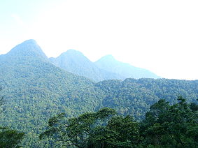 The province has widely varying topography covering high mountains deep valleys; the dominant elevation of the province is in the range 200–600 m (656.2–1,968.5 ft). The province is in the foothills of the Northern Highlands, which forms a broad crescent around the Tonkin Delta; its southern part has narrow river basins and mountain ranges (elevation below 300 metres (984.3 ft)) and the northern part, particularly in Chiem Hoa and Na Hang districts the slopes are steep with hills taller than 1400 metres (4,593.2 ft) (the highest mountain is Cham Chu at 1589 metres (5,213.3 ft)). The Tam Dao range is located in this province.
In the southern part of the province, about 100 kilometres (62.1 mi) away from Hanoi as the crow flies, is the provincial capital, also bearing the name of the capital city of the province, Tuyen Quang has elevation below 100 metres (328.1 ft) located on the right bank of the Lo River (Song Lo), a tributary of the Red River that rises at Ha Giang, near the Chinese border. Its major tributary is the Gam River (Song Gam) on its left bank. The Tuyen Quang province formed by Lo River and Gam River has a land area 5900 square kilometre. The province's territory has only 7.2% of natural forest comprising both rain forest and monsoon forest.
Water resources
The distribution of river and stream network in the province is 0.98 km/km2. There are three main rivers namely, the Lo, Gam and
Pho Day. The Lo River originates in Van Nam, China, flows through Ha Giang to this province; it flows for a length of145 kilometres (90.1 mi) in the province and drains an area of 2090 square kilometre. Its maximum flow is 11,700 m3/s, while the minimum flow recorded is 128 m3/s. It is a navigable river and is a major water route of the province to carry goods to other provinces. The second major river is the Gam River, which also originates in China and flows through Cao Bang and Ha Giang, before entering Tuyen Quang. The Gam River joins the Lo River in Tu Hiep commune. The river flows for 170 kilometres (105.6 mi) length in the province darining an area of 2870 square kilometre. The next major river of importance is the Pho Day River which rises in the Tam Dao Mountain in Bac Kan Province
. It traverses 84 kilometres (52.2 mi) in the province through Yen Son in Son Duong District to Phu Tho and has a drainage area of 800 square kilometre. The navigation possibilities of this river are very limited. In addition to the three major rivers, there is abundance of small rivers, ponds (2000 ponds) and lakes. The total volume of surface water available from all these sources is estimated at 10 BCM. River water is potable, clear but tasteless, has a pH value ranging from 6.5 and 7.5.
The underground water resources of the province, according to preliminary assessments done in the past, was about 3,500,000 m3/ngd. The water is potable with low mineral content. In addition, the province has three mineral water sources
namely, two hot mineral water sources in the forest village of Son Duong District and in My Lam in Yen Son District, and one cool mineral water source in Binh Ca in Son Duong District. The quality of these waters reportedly has mineral salt, which is good for human health and to treat diseases.
Mineral resources
The province has rich metal-mineral and non-metal resources of: Iron ore (10 iron mines with reserve of 10 - 13 million tons in Phuc Ninh, Ha Van, Thau Cay, Cay Vaum Cay Nhan, Dong Ky Lam, Lang Muong and Lang Lech; Lead -zinc ore mines (24 mines) and ore spots at Thuong am - Son Duong, Dong Quan- Binh Ca, Nang Kha Na Hang, Ham Yen-Bac Nhung, Ba Xu- Kien Thiet and Hung Loi- Trung Minh (Thanh Coc) with estimated reserves of lead – zinc (level C2)- 619,298 tons, Pl: 981,482 tons, level P2: 1,032,897 tons.;Tin
ore in Bac Lung, Ky Lam, Thanh Son, Khang Nhat (Ngoi Lem) and Ngon Dong with estimated reserves of 50,000 tons; Vonfram ore with reserves of mineral sand ore of level Cl+ C2= 674 tons WO3; Mangan at six locations in Chiem Hoa with reserves of (in zone of Lang Bai level Cl + C2)- 170,149 tons; Antimony
with reserves of 1,191,000 tons. In addition, Khuon Phuc, Lang Vai and Hoa Phu mines have been explored with nine ore sites in Lang Can, Phieng Giao, Lang ai, Na Mo, Khuon Vai, Coc Tay, Nui Quit and Lung Luong, Nui Than. Barit has been found at 24 ore sites, which could be exploited by open cast mines, in Son Duong, Yen Son and Chiem Hoa districts. Kaolin- felspar is found in Son Duong and Yen Son districts with estimated reserves of 5 million tons. Limestone
in great abundance in the entire province, assessed to be of several billion cubic meters and good for use in manufacture of cement and tiles. Clay is also fairly well distributed in many areas with reserves of several million tons. Minerals such as pirit, gold
and pebble
sand
are also found in small quantities in the province.
Transport network
The province has no railway or airline links. However, the province has National Highway No. 2 and 37 road network. Major Water transport routes are on the Lo, Gam, Pho Day Rivers that connects Tuyen Quang with the neighboring provinces. Tuyen Quang town is 165 kilometres (102.5 mi) away by road from Hanoi.
Climate
The tropical climatic seasons are the monsoon and dry season. Rainfall occurs generally during the monsoon months of May to October, which is also the summer season. However, it is unevenly distributed due to varying topography. The average annual rainfall in the province is 1500 millimetres (59.1 in) in 150 rainy days. Monsoon rainfall accounts for about 94% while the balance occurs during the dry months, which is the winter period. Depending on the season, the wind direction also varies significantly. Thunderstorms from April to August are also a climatic feature with maximum recorded rainfall of 100 millimetres (3.9 in) during one thunderstorm in some areas. Cyclonic effects with wind speed reaching 40 metres (131.2 ft)/s have been recorded in some areas. Cyclones occur every year during the transitional months between two seasons namely April and May. Other weather features noted are Mist and the hoarfrost; mist occurs at the beginning of the winter months; recorded for 25 to 55 days in the south and 60 to 80 days in the North. Hoarfrost occurs once every 2 years on an average during in January or November and for just one day.
The temperate to subtropical, tropical climate facilitates growth of natural flora and a diversified plant mechanism. The northern region of the province experiences a long winter with low temperatures. However ,the region gets more rain during summer. The southern region has a diversified climate with a short winter and hot summer followed by a monsoonal season. Frequently, the strong intensity rainstorms result in floods, which occasionally cause damage to people and property. The average temperature in the province is 22.4 °C (72.3 °F).
and 6 rural districts (huyện): Chiêm Hoá District, Hàm Yên District, Lâm Bình District
, Na Hang District, Sơn Dương District and Yên Sơn District, seven precincts, five towns under districts and 129 communes.
is the staple food. Also grown are maize
, cassava
, potato
, tea
, lemongrass and citrus fruits, as well as bean
s. Livestock includes buffalo
, pig
s and poultry
. The most important mineral reserves are zinc ore, manganese ore, tin and antimony. The province is also a producer of paper, cement and limestone.
The land economy is dependent on the agricultural growth in the province, which is dependent to a land area of 1051 square kilometre) under agriculture, about 20% of the province. However, this has also caused deforestation. However, the practice of shifting cultivation called the "swidden agriculture"(practiced by ethnic minorities) is limited to 3000 ha, as in 1992, and is said to be reducing under a UNDP funded project; has covered the aquaculture development in ponds. However, the Lo River which flows through the province has much potential for development of aquaculture.
The province has 900 villages in upland areas, which are inhabited mostly by impoverished ethnic minorities. Under an IFAD funded project for Rural Development (IFAD loan:US$20.9 million), agricultural training has been provided to the farmers on pilot plots to teach them to adopt new practices and techniques in the field of agriculture, animal husbandry, credit, food storage and processing that are appropriate for the local environment. In addition, infrastructure, health services and village level institutions like the savings and credit groups, user groups and village development boards have also been supported by this funding.
The forestry sector of the economy is influenced by the Bai Bang pulp and paper mill, said to be one of the largest in Vietnam, located in the adjoining Vinh Phu province. It was established in the 1980s with financial help from Sweden. Commercial logging is carried out in the plantation forests by the state-sponsored enterprises to supply pulp to the factory.
Economic indicators
Some of the key economic statistical indicators are as follows.
As against the national figure of 7,592 agriculture, forestry and fishery cooperatives, there are only 147 agriculture cooperatives in the province (142 are farming and 6 are fishery cooperatives). There are 54 farms in the province compared to the national number of 120,699.
The output value of agricultural produce at constant 1994 prices in the province was 959.5 billion đồngs, compared to the national value of 156,681.9 billion dongs.
The province produced 569,400 tonnes of cereals as against the national production of 324,200 tonnes.
The per capita production of cereals in the district was 434.1 kilograms (957 lb) as against the national figure of 501.8 kg in 2007.
In 2007, the industrial output of the province was a meagre 1102.7 billion đồngs against the national output of 1.47 million billion dongs.
Tuyen Quang hydroelectric plant
The Tuyen Quang Hydropower Plant, also known as Dai Thi, is a major hydroelectric power project located within the province on the Gam River near Pac Ta Mountain. Construction began on December 22, 2002 and the first unit was commissioned in March 2008 followed by the two other units by end of 2008. The power plant has a capacity of 342 MW (the second largest in the north), and has an energy generating potential of 1200 GWh/year. The project’s estimated approved cost was US$ 490 million. The project, as built, has a 92 metres (301.8 ft) rock fill dam and 718 metres (2,355.6 ft) long (crest length), called the Na Hang Dam. It has a gross storage capacity of 2.3 billion cubic metres (BCM) (including 1 BCM of flood storage) on the Gam River.
The land use under forest (including bamboo forest) and cultivated land including permanent cropland are mainly in the south of the province. The large closed forest is typical of the northern districts and is widespread in about 12% of the area. Bamboo forests are present recorded in all districts of the province, except Na Hang. The area of forests have reduced due to conversion into agricultural land or because they have become barren. However, this reduction could not be exactly correlated to the changes in the biodiversity of the province.
Flora and fauna
The province has a rich range of flora and fauna. Data compiled for the province has recorded flora from 90 families, 258 classes, and 597 species, and many of them are listed as endangered. The Vietnamese Red Book lists 18 scarce and precious plants in the province including aloe wood, pantace vietnamiensis, textured wood, limestone vatica, hoang dan and abony-tree.
There are 293 faunal species, of which there are 51 animal species belonging to 19 families; there are 175 bird species of 45 families; there are 5 reptile species and 17 amphibian species from 5 families. The animal species are found in abundance, although 39 animal species are listed in the scarce and precious category. Fauna in danger of extinction comprise 18 species of animals, 12 species of birds, 12 species of reptiles and one species of amphibian. The six mammal species particularly identified in the area are the tiger
, the Asian Black Bear, the Clouded Leopard
, the Indian Muntjac
(a small cervine), black gibbon, the apricot panther
, the sambar (another small cervine) and the Sumatran Serow
(a small caprine). The primates identified are the Tonkin snub-nosed monkey
, François' Monkey and Phayre's Leaf Monkey
; the last named is reported to be extinct. The habitat of the mammals, including primates, is stated to be shrinking due to deforestation and expansion of agricultural activities.
churches; 60% of the province is stated to be Catholic.
Provinces of Vietnam
Vietnam is divided into 58 provinces and five centrally governed cities existing at the same level as provinces ....
of Vietnam
Vietnam
Vietnam – sometimes spelled Viet Nam , officially the Socialist Republic of Vietnam – is the easternmost country on the Indochina Peninsula in Southeast Asia. It is bordered by China to the north, Laos to the northwest, Cambodia to the southwest, and the South China Sea –...
, located in the northeastern
Dong Bac
The Northeast is the region at the north of the Red River Delta, Vietnam. Northeast called to distinguish them from the Northwest, but it's actually in the north and northeast of Hanoi, wider than Việt Bắc. The northeast is one of three sub-regions of northern Vietnam...
part of the country to the northwest of Hanoi
Hanoi
Hanoi , is the capital of Vietnam and the country's second largest city. Its population in 2009 was estimated at 2.6 million for urban districts, 6.5 million for the metropolitan jurisdiction. From 1010 until 1802, it was the most important political centre of Vietnam...
, at the centre of Lo River
Lô River
The Lô River is a major river of Vietnam. It flows through Hà Giang Province, Tuyen Quang Province and Phu Tho Province for 470 kilometres and has a basin area of 39,000 km² and originates in Yunnan, China as the Panlong River....
valley, a tributary of the Red River. The delta formation in the province is called the Tonkin Delta
Tonkin
Tonkin , also spelled Tongkin, Tonquin or Tongking, is the northernmost part of Vietnam, south of China's Yunnan and Guangxi Provinces, east of northern Laos, and west of the Gulf of Tonkin. Locally, it is known as Bắc Kỳ, meaning "Northern Region"...
. Its capital is Tuyên Quang
Tuyen Quang
-History:The French post at Tuyen Quang was defended for four months against 12,000 troops of the Yunnan Army and the Black Flag Army by two companies of the French Foreign Legion during the Sino-French War...
Township. The province had a population of 746,900 in 2008, with a density of 127 persons per sqkm over a total land area of 5870.4 square kilometre.
Tuyên Quang borders Hà Giang
Hà Giang Province
Hà Giang is a province in northeastern Vietnam. It is located in the far north of the country, and contains Vietnam’s northernmost point. It shares a 270 km long border with Yunnan province of southern China. Hence it is known as the final frontier of Vietnam...
to the north, Cao Bằng
Cao Bang Province
Cao Bằng is a province of northeastern Vietnam. The province has borders with Hà Giang, Tuyên Quang, Bắc Kạn, and Lạng Sơn provinces within Vietnam. It also has common international border with Guangxi province of the People's Republic of China...
to the northeast, Bắc Kạn
Bắc Kạn Province
Bắc Kạn , also spelt as Bắc Cạn, is a province of Vietnam. It is located in the northeastern part of the country, due north of the capital Hanoi. Bắc Kạn is the only town of the province which is the capital of the province and is a municipality...
and Thái Nguyên
Thai Nguyen Province
Thái Nguyên is a province in northeastern Vietnam. It is a mountainous, midland province with natural area of 3534.45 square kilometres and a population of 1,149,100 people as of 2008...
to the east, Vĩnh Phúc
Vinh Phuc Province
Vĩnh Phúc is a province in the Red River Delta of northern Vietnam. It is divided into one city , one town , and seven districts:#Bình Xuyên#Lập Thạch#Tam Đảo#Tam Dương#Vĩnh Tường#Yên Lạc- Etymology :...
to the south, Phú Thọ
Phu Tho Province
Phú Thọ is a province in northeastern Vietnam. The province's name derives from Sino-Vietnamese and its capital is Viet Tri City, which is away from Hanoi and from the Noi Bai International Airport...
to the southwest, and Yên Bái
Yen Bai Province
Yên Bái is an agricultural-based province located in Tay Bac, the northern part of northern-central Vietnam. It shares borders with five provinces which are Lao Cai province, Lai Chau province, Son La province, Tuyen Quang province, and Phu Tho province...
to the west.
The province is rich in mineral resources. It is also one of the last remaining strongholds of the highly endangered Tonkin snub-nosed monkey. There are 26 registered historical monuments in the province.
History
Tuyen Quang, the capital city of the province has rich history related to the battles fought in the region. The earliest history is to the First Indochina WarFirst Indochina War
The First Indochina War was fought in French Indochina from December 19, 1946, until August 1, 1954, between the French Union's French Far East...
when it served as a garrison. During this war the Viet Minh
Viet Minh
Việt Minh was a national independence coalition formed at Pac Bo on May 19, 1941. The Việt Minh initially formed to seek independence for Vietnam from the French Empire. When the Japanese occupation began, the Việt Minh opposed Japan with support from the United States and the Republic of China...
made the Legionnaires surrender at the memorial to the Battle of Tuyen Quang.
Another historical event is the Siege of Tuyen Quang
Siege of Tuyen Quang
The Siege of Tuyen Quang was an important confrontation between the French and the Chinese armies in Tonkin during the Sino-French War...
, which is still remembered as one of the French Legion's most celebrated feats of arms, and is also commemorated in the first verse of Le Boudin
Le Boudin
Le Boudin is the official march of the French Foreign Legion. Le Boudin is a reference to boudin, a type of blood sausage or black pudding. Le boudin colloquially meant the gear that used to top the backpacks of Legionnaires...
, its principal marching song. The French garrison posted at Tuyen Quang defended the town for four months against 12,000 troops of the Yunnan
Yunnan
Yunnan is a province of the People's Republic of China, located in the far southwest of the country spanning approximately and with a population of 45.7 million . The capital of the province is Kunming. The province borders Burma, Laos, and Vietnam.Yunnan is situated in a mountainous area, with...
Army and the Black Flag Army
Black Flag Army
The Black Flag Army was a splinter remnant of a bandit group recruited largely from soldiers of ethnic Zhuang background, who crossed the border from Guangxi province of China into Upper Tonkin, in the Empire of Annam in 1865. They became known mainly for their fights against French forces in...
. Two companies of the French Foreign Legion
French Foreign Legion
The French Foreign Legion is a unique military service wing of the French Army established in 1831. The foreign legion was exclusively created for foreign nationals willing to serve in the French Armed Forces...
were involved during the Sino-French War
Sino-French War
The Sino–French War was a limited conflict fought between August 1884 and April 1885 to decide whether France should replace China in control of Tonkin . As the French achieved their war aims, they are usually considered to have won the war...
(August 1884 to April 1885).
Tuyên Quang used to be entirely settled by Thai people, but from the 13th century onwards were integrated into the Tran dynasty, who named it Quốc Oai
Quoc Oai
Quốc Oai is a district of Hanoi in the Red River Delta region of Vietnam....
before naming it Châu Tuyên Quang. Under the rule of Emperor Trần Hiến Tông
Trần Hiến Tông
Trần Hiến Tông , given name Trần Vượng , was the sixth emperor of the Trần Dynasty who reigned Đại Việt from 1329 to 1341. Enthroned by Minh Tông when he was only a ten-year-old boy, Hiến Tông ruled Đại Việt with the regent of the Retired Emperor Minh Tông during his thirteen years of reign...
(reigned 1329–1341), Tuyên Quang was given the status of a trấn, before being categorised a thành phủ when the Ming Dynasty
Ming Dynasty
The Ming Dynasty, also Empire of the Great Ming, was the ruling dynasty of China from 1368 to 1644, following the collapse of the Mongol-led Yuan Dynasty. The Ming, "one of the greatest eras of orderly government and social stability in human history", was the last dynasty in China ruled by ethnic...
of China briefly annexed Vietnam at the start of the 15th century. After Le Loi expelled the Chinese and started the Le Dynasty
Lê Dynasty
The Later Lê Dynasty , sometimes referred to as the Lê Dynasty was the longest-ruling dynasty of Vietnam, ruling the country from 1428 to 1788, with a brief interruption....
, he made Tuyên Hóa a part of Tây Đạo. During the reign of Emperor Lê Thánh Tông
Lê Thánh Tông
Lê Thánh Tông was emperor of Đại Việt from 1460 until his death. He is generally regarded as one of the greatest emperors of Vietnamese history and the Vietnamese "Hammurabi."-Early years:...
, Tuyên Quang comprised one phủ and five districts (huyện) and became the province of Minh Quang under the rule of Emperor Lê Uy Mục. During the reign of Lê Trang Tông, Minh Quang became An Tại, and control of the region was given to the Vũ family, ethnic Thais.
By the end of 17th century, the Le Dynasty sent ethnic Vietnamese officials to the area to supervise the Thais. After Gia Long
Gia Long
Emperor Gia Long , born Nguyễn Phúc Ánh , was an emperor of Vietnam...
started the Nguyen Dynasty, he changed the region to the trấn of Tuyên Quang, and it became a province under the rule of his successor Emperor Minh Mạng
Minh Mang
Minh Mạng was the second emperor of the Nguyễn Dynasty of Vietnam, reigning from 14 February 1820 until 20 January 1841. He was a younger son of Emperor Gia Long, whose eldest son, Crown Prince Canh, had died in 1801...
. When the French carried out their colonial conquest, the phủ of Yên Bình was at the forefront of the resistance movement. People from the Thái, Mường, Mèo, Thổ, Nùng and another ethnic groups engaged the French in many battles in the area in 1884–85. The Black Flags
Black Flag Army
The Black Flag Army was a splinter remnant of a bandit group recruited largely from soldiers of ethnic Zhuang background, who crossed the border from Guangxi province of China into Upper Tonkin, in the Empire of Annam in 1865. They became known mainly for their fights against French forces in...
were also prominent. It was not until 1894 that the French had pacified the region.
Before 1975, the province comprised the districts of Yên Sơn
Yên Sơn
Yên Sơn is a commune and village in Lục Nam District, Bac Giang Province, in northeastern Vietnam.-References:...
, Yên Bình
Yen Binh
Yen Binh is a district of Yen Bai Province, in the northeastern region of Vietnam....
, Hàm Yên
Ham Yen
Ham Yen is a district of Tuyen Quang Province in the northeastern region of Vietnam.As of 2003 the district had a population of 104,648. The district covers an area of 898 km²...
, Sơn Dương
Son Duong
Sơn Dương is a rural district of Tuyen Quang province in the northeastern region of Vietnam. the district had a population of 174,118. The district covers an area of 789 km². The district capital lies at Son Duong.-References:...
, Chiêm Hóa
Chiem Hoa
Chiêm Hoá is a rural district of Tuyen Quang province in the northeastern region of Vietnam. As of 2003 the district had a population of 132,722. The district covers an area of 1456 km²...
and Đại Thi.
Geography and climate
In the southern part of the province, about 100 kilometres (62.1 mi) away from Hanoi as the crow flies, is the provincial capital, also bearing the name of the capital city of the province, Tuyen Quang has elevation below 100 metres (328.1 ft) located on the right bank of the Lo River (Song Lo), a tributary of the Red River that rises at Ha Giang, near the Chinese border. Its major tributary is the Gam River (Song Gam) on its left bank. The Tuyen Quang province formed by Lo River and Gam River has a land area 5900 square kilometre. The province's territory has only 7.2% of natural forest comprising both rain forest and monsoon forest.
Water resources
The distribution of river and stream network in the province is 0.98 km/km2. There are three main rivers namely, the Lo, Gam and
Pho Day. The Lo River originates in Van Nam, China, flows through Ha Giang to this province; it flows for a length of145 kilometres (90.1 mi) in the province and drains an area of 2090 square kilometre. Its maximum flow is 11,700 m3/s, while the minimum flow recorded is 128 m3/s. It is a navigable river and is a major water route of the province to carry goods to other provinces. The second major river is the Gam River, which also originates in China and flows through Cao Bang and Ha Giang, before entering Tuyen Quang. The Gam River joins the Lo River in Tu Hiep commune. The river flows for 170 kilometres (105.6 mi) length in the province darining an area of 2870 square kilometre. The next major river of importance is the Pho Day River which rises in the Tam Dao Mountain in Bac Kan Province
Bắc Kạn Province
Bắc Kạn , also spelt as Bắc Cạn, is a province of Vietnam. It is located in the northeastern part of the country, due north of the capital Hanoi. Bắc Kạn is the only town of the province which is the capital of the province and is a municipality...
. It traverses 84 kilometres (52.2 mi) in the province through Yen Son in Son Duong District to Phu Tho and has a drainage area of 800 square kilometre. The navigation possibilities of this river are very limited. In addition to the three major rivers, there is abundance of small rivers, ponds (2000 ponds) and lakes. The total volume of surface water available from all these sources is estimated at 10 BCM. River water is potable, clear but tasteless, has a pH value ranging from 6.5 and 7.5.
The underground water resources of the province, according to preliminary assessments done in the past, was about 3,500,000 m3/ngd. The water is potable with low mineral content. In addition, the province has three mineral water sources
namely, two hot mineral water sources in the forest village of Son Duong District and in My Lam in Yen Son District, and one cool mineral water source in Binh Ca in Son Duong District. The quality of these waters reportedly has mineral salt, which is good for human health and to treat diseases.
Mineral resources
The province has rich metal-mineral and non-metal resources of: Iron ore (10 iron mines with reserve of 10 - 13 million tons in Phuc Ninh, Ha Van, Thau Cay, Cay Vaum Cay Nhan, Dong Ky Lam, Lang Muong and Lang Lech; Lead -zinc ore mines (24 mines) and ore spots at Thuong am - Son Duong, Dong Quan- Binh Ca, Nang Kha Na Hang, Ham Yen-Bac Nhung, Ba Xu- Kien Thiet and Hung Loi- Trung Minh (Thanh Coc) with estimated reserves of lead – zinc (level C2)- 619,298 tons, Pl: 981,482 tons, level P2: 1,032,897 tons.;Tin
Tin
Tin is a chemical element with the symbol Sn and atomic number 50. It is a main group metal in group 14 of the periodic table. Tin shows chemical similarity to both neighboring group 14 elements, germanium and lead and has two possible oxidation states, +2 and the slightly more stable +4...
ore in Bac Lung, Ky Lam, Thanh Son, Khang Nhat (Ngoi Lem) and Ngon Dong with estimated reserves of 50,000 tons; Vonfram ore with reserves of mineral sand ore of level Cl+ C2= 674 tons WO3; Mangan at six locations in Chiem Hoa with reserves of (in zone of Lang Bai level Cl + C2)- 170,149 tons; Antimony
Antimony
Antimony is a toxic chemical element with the symbol Sb and an atomic number of 51. A lustrous grey metalloid, it is found in nature mainly as the sulfide mineral stibnite...
with reserves of 1,191,000 tons. In addition, Khuon Phuc, Lang Vai and Hoa Phu mines have been explored with nine ore sites in Lang Can, Phieng Giao, Lang ai, Na Mo, Khuon Vai, Coc Tay, Nui Quit and Lung Luong, Nui Than. Barit has been found at 24 ore sites, which could be exploited by open cast mines, in Son Duong, Yen Son and Chiem Hoa districts. Kaolin- felspar is found in Son Duong and Yen Son districts with estimated reserves of 5 million tons. Limestone
Limestone
Limestone is a sedimentary rock composed largely of the minerals calcite and aragonite, which are different crystal forms of calcium carbonate . Many limestones are composed from skeletal fragments of marine organisms such as coral or foraminifera....
in great abundance in the entire province, assessed to be of several billion cubic meters and good for use in manufacture of cement and tiles. Clay is also fairly well distributed in many areas with reserves of several million tons. Minerals such as pirit, gold
Gold
Gold is a chemical element with the symbol Au and an atomic number of 79. Gold is a dense, soft, shiny, malleable and ductile metal. Pure gold has a bright yellow color and luster traditionally considered attractive, which it maintains without oxidizing in air or water. Chemically, gold is a...
and pebble
Pebble
A pebble is a clast of rock with a particle size of 4 to 64 millimetres based on the Krumbein phi scale of sedimentology. Pebbles are generally considered to be larger than granules and smaller than cobbles . A rock made predominantly of pebbles is termed a conglomerate...
sand
Sand
Sand is a naturally occurring granular material composed of finely divided rock and mineral particles.The composition of sand is highly variable, depending on the local rock sources and conditions, but the most common constituent of sand in inland continental settings and non-tropical coastal...
are also found in small quantities in the province.
Transport network
The province has no railway or airline links. However, the province has National Highway No. 2 and 37 road network. Major Water transport routes are on the Lo, Gam, Pho Day Rivers that connects Tuyen Quang with the neighboring provinces. Tuyen Quang town is 165 kilometres (102.5 mi) away by road from Hanoi.
Climate
The tropical climatic seasons are the monsoon and dry season. Rainfall occurs generally during the monsoon months of May to October, which is also the summer season. However, it is unevenly distributed due to varying topography. The average annual rainfall in the province is 1500 millimetres (59.1 in) in 150 rainy days. Monsoon rainfall accounts for about 94% while the balance occurs during the dry months, which is the winter period. Depending on the season, the wind direction also varies significantly. Thunderstorms from April to August are also a climatic feature with maximum recorded rainfall of 100 millimetres (3.9 in) during one thunderstorm in some areas. Cyclonic effects with wind speed reaching 40 metres (131.2 ft)/s have been recorded in some areas. Cyclones occur every year during the transitional months between two seasons namely April and May. Other weather features noted are Mist and the hoarfrost; mist occurs at the beginning of the winter months; recorded for 25 to 55 days in the south and 60 to 80 days in the North. Hoarfrost occurs once every 2 years on an average during in January or November and for just one day.
The temperate to subtropical, tropical climate facilitates growth of natural flora and a diversified plant mechanism. The northern region of the province experiences a long winter with low temperatures. However ,the region gets more rain during summer. The southern region has a diversified climate with a short winter and hot summer followed by a monsoonal season. Frequently, the strong intensity rainstorms result in floods, which occasionally cause damage to people and property. The average temperature in the province is 22.4 °C (72.3 °F).
Administrative divisions
Tuyên Quang is divided into: one town municipality (thị xã) Tuyên QuangTuyen Quang
-History:The French post at Tuyen Quang was defended for four months against 12,000 troops of the Yunnan Army and the Black Flag Army by two companies of the French Foreign Legion during the Sino-French War...
and 6 rural districts (huyện): Chiêm Hoá District, Hàm Yên District, Lâm Bình District
Lâm Bình District
Lâm Bình is a rural district of Tuyen Quang province in the northeastern region of Vietnam. It's a new district in Vietnam, created in January, 2011. Its area come from communes of Na Hang District and Chiem Hoa District. As of 2011 the district had a population of 29,459. The district covers an...
, Na Hang District, Sơn Dương District and Yên Sơn District, seven precincts, five towns under districts and 129 communes.
| Name | Division type | Population (2003) | Area (km²) | Towns (huyện lỵ or thị trấn) (bold) and communes (xã) |
|---|---|---|---|---|
| Tuyên Quang Tuyen Quang -History:The French post at Tuyen Quang was defended for four months against 12,000 troops of the Yunnan Army and the Black Flag Army by two companies of the French Foreign Legion during the Sino-French War... |
Township (thị xã) | 139,000 | 119.17 | Wards (phường):Hưng Thành, Nông Tiến, Ỷ La, Minh Xuân, Phan Thiết, Tân Quang, Tân Hà. Communes: Tràng Đà, An Tường, Lưỡng Vượng, An Khang, Thái Long, Đội Cấn. |
| Chiêm Hoá District | District (huyện) | 124,337 | 1280.379 | Vĩnh Lộc Town, Minh Quang, Trung Hà, Hà Lang, Phúc Sơn, Tân Mỹ, Hùng Mỹ, Tân An, Hòa An, Trung Hòa, Nhân Lý, Bình Nhân, Vinh Quang, Kim Bình, Tri Phú, Linh Phú, Ngọc Hội, Phú Bình, Bình Phú, Kiên Đài, Yên Lập, Xuân Quang, Phúc Thịnh, Tân Thịnh, Yên Nguyên, Hòa Phú. |
| Hàm Yên District | District (huyện) | 104,648 | 346.7 | Tân Yên Town, Hùng Đức, Bằng Cốc,Thành Long, Thái Hòa,Đức Ninh,Thái Sơn, Bình Xa, Nhân Mục, Yên Phú, Tân Thành, Minh Hương, Phù Lưu, Minh Dân,Yên Lâm,Minh Khương, Bạch Xa,Yên Thuận. |
| Lâm Bình District Lâm Bình District Lâm Bình is a rural district of Tuyen Quang province in the northeastern region of Vietnam. It's a new district in Vietnam, created in January, 2011. Its area come from communes of Na Hang District and Chiem Hoa District. As of 2011 the district had a population of 29,459. The district covers an... |
District (huyện) | 29,459 | 781.522 | Lăng Can, Thượng Lâm, Khuôn Hà, Phúc Yên, Xuân Lập, Bình An, Thổ Bình, Hồng Quang. |
| Nà Hang District | District (huyện) | 41,868 | 865.497 | Na Hang Town, Năng Khả, Thanh Tương, Sơn Phú, Đà Vị, Yên Hoa, Côn Lôn, Sinh Long, Khâu Tinh, Thượng Giáp, Thượng Nông, Hồng Thái. |
| Sơn Dương District | District (huyện) | 174,118 | 789 | |
| Yên Sơn District | District (huyện) | 175,917 | 1210 | Tân Bình Town, Đội Bình, Nhữ Khê, Nhữ Hán, Mỹ Bằng, Phú Lâm, Kim Phú, Hoàng Khai, Chân Sơn, Trung Môn, Lang Quán, Thắng Quân, Tứ Quận, Phúc Ninh, Chiêu Yên, Lực Hành, Quý Quân,Xuân Vân, Tân Long, Tân Tiến, Trung Trực, Kiến Thiết, Đạo Viện, Phú Thịnh,Thái Bình, Tiến Bộ, Công Đa, Kim Quan, Trung Sơn, Hùng Lợi,Trung Minh. |
Demographics
According to the General Statistics Office of the Government of Vietnam, the population of Tuyen Quang Province as of 2008 was 746,900 with a density of 127 persons per square kilometre over a total land area of 5870.4 square kilometre of the province. The male population during this period was 369,100 with females accounting for 377,800. The rural population was 676,200 against an urban population of 70,700.Economy and development
The province's economy is dependent on its primary industries. In 2005, the economic breakdown is as follows: construction 30.7%, services 33.6%, agriculture, forestry and fishery 35.7%. RiceRice
Rice is the seed of the monocot plants Oryza sativa or Oryza glaberrima . As a cereal grain, it is the most important staple food for a large part of the world's human population, especially in East Asia, Southeast Asia, South Asia, the Middle East, and the West Indies...
is the staple food. Also grown are maize
Maize
Maize known in many English-speaking countries as corn or mielie/mealie, is a grain domesticated by indigenous peoples in Mesoamerica in prehistoric times. The leafy stalk produces ears which contain seeds called kernels. Though technically a grain, maize kernels are used in cooking as a vegetable...
, cassava
Cassava
Cassava , also called yuca or manioc, a woody shrub of the Euphorbiaceae native to South America, is extensively cultivated as an annual crop in tropical and subtropical regions for its edible starchy tuberous root, a major source of carbohydrates...
, potato
Potato
The potato is a starchy, tuberous crop from the perennial Solanum tuberosum of the Solanaceae family . The word potato may refer to the plant itself as well as the edible tuber. In the region of the Andes, there are some other closely related cultivated potato species...
, tea
Tea
Tea is an aromatic beverage prepared by adding cured leaves of the Camellia sinensis plant to hot water. The term also refers to the plant itself. After water, tea is the most widely consumed beverage in the world...
, lemongrass and citrus fruits, as well as bean
Bean
Bean is a common name for large plant seeds of several genera of the family Fabaceae used for human food or animal feed....
s. Livestock includes buffalo
Water Buffalo
The water buffalo or domestic Asian water buffalo is a large bovine animal, frequently used as livestock in southern Asia, and also widely in South America, southern Europe, northern Africa, and elsewhere....
, pig
Pig
A pig is any of the animals in the genus Sus, within the Suidae family of even-toed ungulates. Pigs include the domestic pig, its ancestor the wild boar, and several other wild relatives...
s and poultry
Poultry
Poultry are domesticated birds kept by humans for the purpose of producing eggs, meat, and/or feathers. These most typically are members of the superorder Galloanserae , especially the order Galliformes and the family Anatidae , commonly known as "waterfowl"...
. The most important mineral reserves are zinc ore, manganese ore, tin and antimony. The province is also a producer of paper, cement and limestone.
The land economy is dependent on the agricultural growth in the province, which is dependent to a land area of 1051 square kilometre) under agriculture, about 20% of the province. However, this has also caused deforestation. However, the practice of shifting cultivation called the "swidden agriculture"(practiced by ethnic minorities) is limited to 3000 ha, as in 1992, and is said to be reducing under a UNDP funded project; has covered the aquaculture development in ponds. However, the Lo River which flows through the province has much potential for development of aquaculture.
The province has 900 villages in upland areas, which are inhabited mostly by impoverished ethnic minorities. Under an IFAD funded project for Rural Development (IFAD loan:US$20.9 million), agricultural training has been provided to the farmers on pilot plots to teach them to adopt new practices and techniques in the field of agriculture, animal husbandry, credit, food storage and processing that are appropriate for the local environment. In addition, infrastructure, health services and village level institutions like the savings and credit groups, user groups and village development boards have also been supported by this funding.
The forestry sector of the economy is influenced by the Bai Bang pulp and paper mill, said to be one of the largest in Vietnam, located in the adjoining Vinh Phu province. It was established in the 1980s with financial help from Sweden. Commercial logging is carried out in the plantation forests by the state-sponsored enterprises to supply pulp to the factory.
Economic indicators
Some of the key economic statistical indicators are as follows.
As against the national figure of 7,592 agriculture, forestry and fishery cooperatives, there are only 147 agriculture cooperatives in the province (142 are farming and 6 are fishery cooperatives). There are 54 farms in the province compared to the national number of 120,699.
The output value of agricultural produce at constant 1994 prices in the province was 959.5 billion đồngs, compared to the national value of 156,681.9 billion dongs.
The province produced 569,400 tonnes of cereals as against the national production of 324,200 tonnes.
The per capita production of cereals in the district was 434.1 kilograms (957 lb) as against the national figure of 501.8 kg in 2007.
In 2007, the industrial output of the province was a meagre 1102.7 billion đồngs against the national output of 1.47 million billion dongs.
Tuyen Quang hydroelectric plant
The Tuyen Quang Hydropower Plant, also known as Dai Thi, is a major hydroelectric power project located within the province on the Gam River near Pac Ta Mountain. Construction began on December 22, 2002 and the first unit was commissioned in March 2008 followed by the two other units by end of 2008. The power plant has a capacity of 342 MW (the second largest in the north), and has an energy generating potential of 1200 GWh/year. The project’s estimated approved cost was US$ 490 million. The project, as built, has a 92 metres (301.8 ft) rock fill dam and 718 metres (2,355.6 ft) long (crest length), called the Na Hang Dam. It has a gross storage capacity of 2.3 billion cubic metres (BCM) (including 1 BCM of flood storage) on the Gam River.
Biodiversity
ForestThe land use under forest (including bamboo forest) and cultivated land including permanent cropland are mainly in the south of the province. The large closed forest is typical of the northern districts and is widespread in about 12% of the area. Bamboo forests are present recorded in all districts of the province, except Na Hang. The area of forests have reduced due to conversion into agricultural land or because they have become barren. However, this reduction could not be exactly correlated to the changes in the biodiversity of the province.
Flora and fauna
The province has a rich range of flora and fauna. Data compiled for the province has recorded flora from 90 families, 258 classes, and 597 species, and many of them are listed as endangered. The Vietnamese Red Book lists 18 scarce and precious plants in the province including aloe wood, pantace vietnamiensis, textured wood, limestone vatica, hoang dan and abony-tree.
There are 293 faunal species, of which there are 51 animal species belonging to 19 families; there are 175 bird species of 45 families; there are 5 reptile species and 17 amphibian species from 5 families. The animal species are found in abundance, although 39 animal species are listed in the scarce and precious category. Fauna in danger of extinction comprise 18 species of animals, 12 species of birds, 12 species of reptiles and one species of amphibian. The six mammal species particularly identified in the area are the tiger
Tiger
The tiger is the largest cat species, reaching a total body length of up to and weighing up to . Their most recognizable feature is a pattern of dark vertical stripes on reddish-orange fur with lighter underparts...
, the Asian Black Bear, the Clouded Leopard
Clouded Leopard
The clouded leopard is a felid found from the Himalayan foothills through mainland Southeast Asia into China, and has been classified as vulnerable in 2008 by IUCN...
, the Indian Muntjac
Indian Muntjac
The Common Muntjac , also called the Red Muntjac, Indian Muntjac or Barking deer is the most numerous muntjac deer species. It has soft, short, brownish or greyish hair, sometimes with creamy markings. This species is omnivorous, feeding on fruits, shoots, seeds, birds' eggs as well as small...
(a small cervine), black gibbon, the apricot panther
Panthera
Panthera is a genus of the family Felidae , which contains four well-known living species: the tiger, the lion, the jaguar, and the leopard. The genus comprises about half of the Pantherinae subfamily, the big cats...
, the sambar (another small cervine) and the Sumatran Serow
Sumatran Serow
The Sumatran Serow , also known as the Southern Serow, is a species of goat-antelope native to mountain forests in the Thai-Malay Peninsula and on the Indonesian island of Sumatra. The former name of this species is "mainland serow", as all the mainland species of serow used to be considered...
(a small caprine). The primates identified are the Tonkin snub-nosed monkey
Snub-nosed monkey
Snub-nosed monkeys are a group of Old World monkeys and make up the entirety of the genus Rhinopithecus. The genus occurs rarely and needs much more research...
, François' Monkey and Phayre's Leaf Monkey
Phayre's Leaf Monkey
Phayre's leaf monkey , also known as Phayre's langur, is a species of lutung found in Southeast Asia. The species epithet commemorates Arthur Purves Phayre....
; the last named is reported to be extinct. The habitat of the mammals, including primates, is stated to be shrinking due to deforestation and expansion of agricultural activities.
Historical places
Historical places in the province include the Cave Pagoda at Yen Son; the Dat Nong Tien and the Thuong Temple in Tuyen Quang. The natural beauty of the province is provided by the mountain ranges with peaks exceeding 2000 metres (6,561.7 ft), and the My Lan Spring. There are 26 registered historical monuments, eight cultural centres and 42 communal cultural houses in the province. The predominant Christian churches in the province are the seven CatholicCatholic
The word catholic comes from the Greek phrase , meaning "on the whole," "according to the whole" or "in general", and is a combination of the Greek words meaning "about" and meaning "whole"...
churches; 60% of the province is stated to be Catholic.