
.gif)
Tropical Storm Felice (1970)
Encyclopedia
Tropical Storm Felice was a mid-September tropical storm that formed during the 1970 Atlantic hurricane season
. The seventh tropical cyclone of the 1970 season, Felice formed over the Bahamas as a tropical depression on September 12 and crossed southern Florida
where it reached tropical storm strength in the Gulf of Mexico
. The storm traveled northwest peaking at 70 mph (110 km/h) where it made landfall near High Island, Texas
. After landfall, Felice recurved and moved inland over central and northern Texas
as a tropical depression before dissipating on September 17.
Tropical Storm Felice dropped heavy rainfall across southern Florida
, Texas
, Oklahoma
and Arkansas
. The resulting rainfall caused minor flood damage and there were no fatalities or injuries as a result of Felice's impact on the United States
.
and the Florida Keys
. Initially, the depression was not forecast to strengthened rapidly into a tropical storm due to unfavorable conditions around it. The tropical depression then turned northwestward where it slowly reached tropical storm strength on September 14 and was named Felice by the National Hurricane Center
.
The following day, the winds of Felice increased to 55 mph (90 km/h) as the center of the storm was located 300 miles (480 km) southeast of Louisiana
. The winds of Felice extended for 100 miles (160 km) to the north of the center as the storm continued on its west-northwest track at speeds of 14-15 mph (23–24 km/h). Because Felice was a poorly organized tropical storm in its early stages, forecasters had a difficult time to track its movement. Initially, forecasters thought that a new center had formed north of the previous track based on data from a radar station in New Orleans, however that claim was rejected because of technical problems and the poor organization of the storm.
As Felice continued moving northwest, meteorologists at the National Hurricane Center
initially forecast the storm to reach hurricane strength in the next 24 hours. However, strengthening was slow since the storm was still poorly organized. Despite this, Felice's winds continue to strengthen to 60 mph (97 km/h) as the storm continued to move west-northwest at 18 mph (29 km/h) as the storm moved 130 miles south of New Orleans, Louisiana
. Felice's winds peaked at 70 mph and the pressure fell to 997 millibars as the storm made landfall near High Island
. After making landfall, Felice turned northward and crossed northern Texas
and drifted over southeastern Oklahoma
where radars at the Storm Prediction Center
(then known as the National Severe Storms Laboratory) in Norman, Oklahoma
depicted the dying storm having an eye-like
structure. Felice then dissipated on September 17 as result of cooler air entering the storm.
 The National Hurricane Center
issued a hurricane watch extending from Morgan City, Louisiana
to Galveston, Texas
. Residents living along the Texas
coastline were advised to take precautions and boats and small water craft were advised to remain in port. Meteorologists also forecast the storm to bring gusty winds to the Mississippi
coastline. In Jefferson County, Texas
, officials urged residents to evacuate early if the storm intensifies fearing that last minute evacuation would make Highway 59 impassable because an alternate evacuation route was closed due to fire resulting from a collision between a boat and barge two days earlier. In Sabine Pass
, the approach of the storm forced the evacuation of 1,200 residents living in low lying areas. In Cameron, Louisiana
, 3,000 residents evacuated.
Felice affected the Bahamas and southern Florida
as a tropical depression. In Florida
, the effects from Felice was limited to heavy rainfall with 3 inches (76.2 mm) reported near Miami
and the southeastern part of the state. In Louisiana
, tides 3.9 ft (1.2 meters) were reported near Cameron
. The storm also produced moderate to heavy rainfall across southeastern and western Louisiana
In Grand Chenier, Louisiana
, a weather station reported sustained winds of 26 mph (42 km/h) with gusts up to 42 mph (68 km/h).
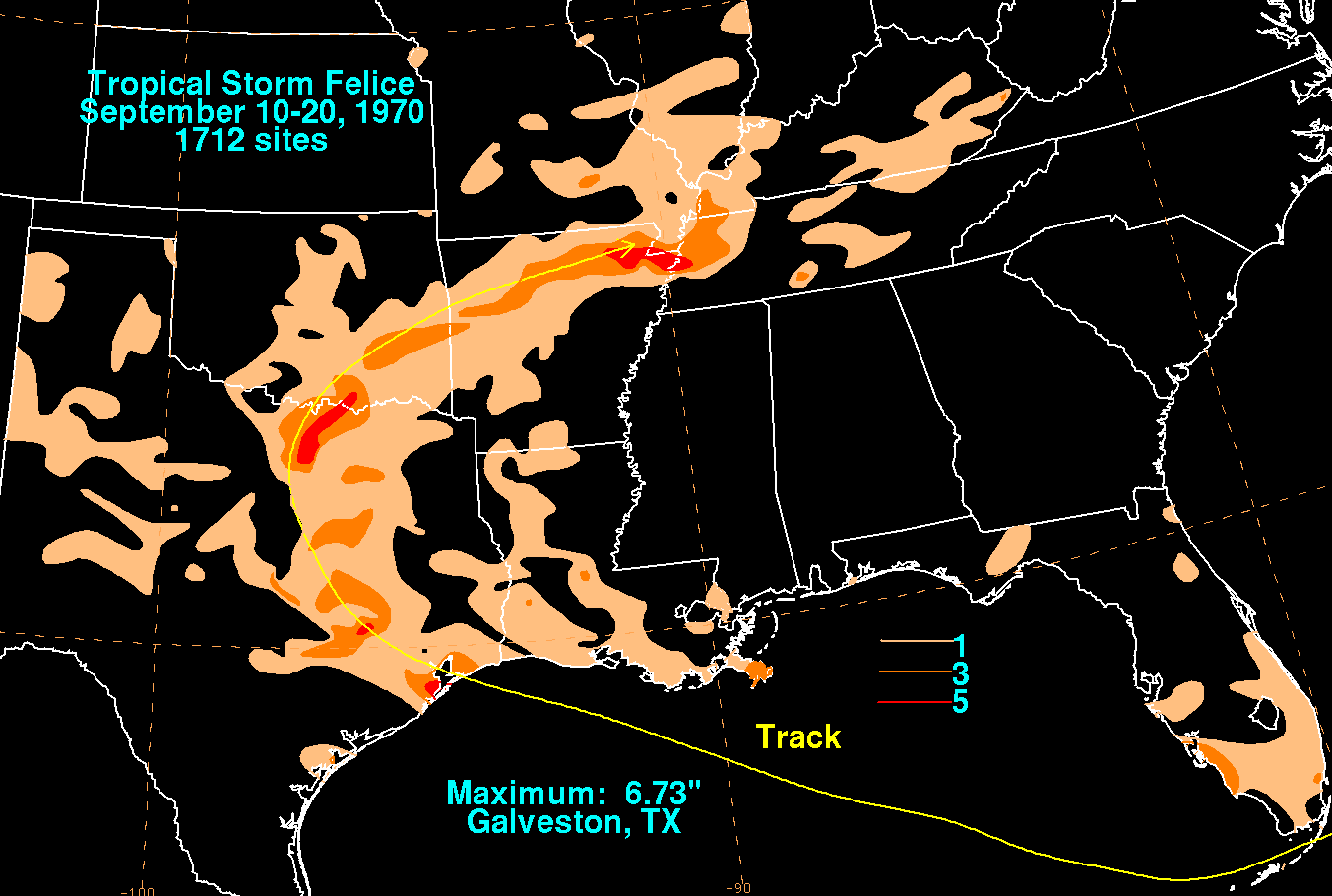
In Texas
, Felice brought high winds and heavy rains. In Galveston
, a weather station reported a gust of 54 mph (87 km/h) and rainfall peaking at 6.73 inches (152.4 mm). The heavy rainfall caused minor flooding and lightning from the storm damaged a transformer
leaving residents in the eastern part of Galveston without power. Wind damage in the city was limited to trees one of which damaged a parked car. Offshore, the storm brought a storm tide of 2 feet (0.7 meters) above normal. Elsewhere in Texas
the storm brought heavy rainfall In Houston
, the storm brought winds of 30 mph (48 km/h) with gusts up to 46 mph (74 km/h) and rainfall of 1.97 inches (50.8 mm). Inland, the heavy rainfall from the storm caused minimal damage to rice
crops. In Oklahoma
, dropped heavy rainfall across southeastern portions of the state and as the remnants of the storm passed through the Central United States
, it dropped rainfall up to 3 inches (76.2 mm) over northeastern Arkansas
.
1970 Atlantic hurricane season
The 1970 Atlantic hurricane season officially began on June 1, 1970, and lasted until November 30, 1970. These dates conventionally delimit the period of each year when most tropical cyclones form in the Atlantic basin...
. The seventh tropical cyclone of the 1970 season, Felice formed over the Bahamas as a tropical depression on September 12 and crossed southern Florida
Florida
Florida is a state in the southeastern United States, located on the nation's Atlantic and Gulf coasts. It is bordered to the west by the Gulf of Mexico, to the north by Alabama and Georgia and to the east by the Atlantic Ocean. With a population of 18,801,310 as measured by the 2010 census, it...
where it reached tropical storm strength in the Gulf of Mexico
Gulf of Mexico
The Gulf of Mexico is a partially landlocked ocean basin largely surrounded by the North American continent and the island of Cuba. It is bounded on the northeast, north and northwest by the Gulf Coast of the United States, on the southwest and south by Mexico, and on the southeast by Cuba. In...
. The storm traveled northwest peaking at 70 mph (110 km/h) where it made landfall near High Island, Texas
High Island, Texas
High Island is an unincorporated area located in the Bolivar Peninsula census-designated place, Galveston County, Texas, United States. The community is located in the extreme eastern part of the county on Bolivar Peninsula, less than one mile from Chambers County and less than two miles from...
. After landfall, Felice recurved and moved inland over central and northern Texas
Texas
Texas is the second largest U.S. state by both area and population, and the largest state by area in the contiguous United States.The name, based on the Caddo word "Tejas" meaning "friends" or "allies", was applied by the Spanish to the Caddo themselves and to the region of their settlement in...
as a tropical depression before dissipating on September 17.
Tropical Storm Felice dropped heavy rainfall across southern Florida
Florida
Florida is a state in the southeastern United States, located on the nation's Atlantic and Gulf coasts. It is bordered to the west by the Gulf of Mexico, to the north by Alabama and Georgia and to the east by the Atlantic Ocean. With a population of 18,801,310 as measured by the 2010 census, it...
, Texas
Texas
Texas is the second largest U.S. state by both area and population, and the largest state by area in the contiguous United States.The name, based on the Caddo word "Tejas" meaning "friends" or "allies", was applied by the Spanish to the Caddo themselves and to the region of their settlement in...
, Oklahoma
Oklahoma
Oklahoma is a state located in the South Central region of the United States of America. With an estimated 3,751,351 residents as of the 2010 census and a land area of 68,667 square miles , Oklahoma is the 28th most populous and 20th-largest state...
and Arkansas
Arkansas
Arkansas is a state located in the southern region of the United States. Its name is an Algonquian name of the Quapaw Indians. Arkansas shares borders with six states , and its eastern border is largely defined by the Mississippi River...
. The resulting rainfall caused minor flood damage and there were no fatalities or injuries as a result of Felice's impact on the United States
United States
The United States of America is a federal constitutional republic comprising fifty states and a federal district...
.
Meteorological history
An upper level low persisted over the Bahamas where it became a tropical depression on September 12. The depression drifted southwestward bypassing southern FloridaFlorida
Florida is a state in the southeastern United States, located on the nation's Atlantic and Gulf coasts. It is bordered to the west by the Gulf of Mexico, to the north by Alabama and Georgia and to the east by the Atlantic Ocean. With a population of 18,801,310 as measured by the 2010 census, it...
and the Florida Keys
Florida Keys
The Florida Keys are a coral archipelago in southeast United States. They begin at the southeastern tip of the Florida peninsula, about south of Miami, and extend in a gentle arc south-southwest and then westward to Key West, the westernmost of the inhabited islands, and on to the uninhabited Dry...
. Initially, the depression was not forecast to strengthened rapidly into a tropical storm due to unfavorable conditions around it. The tropical depression then turned northwestward where it slowly reached tropical storm strength on September 14 and was named Felice by the National Hurricane Center
National Hurricane Center
The National Hurricane Center , located at Florida International University in Miami, Florida, is the division of the National Weather Service responsible for tracking and predicting weather systems within the tropics between the Prime Meridian and the 140th meridian west poleward to the 30th...
.
The following day, the winds of Felice increased to 55 mph (90 km/h) as the center of the storm was located 300 miles (480 km) southeast of Louisiana
Louisiana
Louisiana is a state located in the southern region of the United States of America. Its capital is Baton Rouge and largest city is New Orleans. Louisiana is the only state in the U.S. with political subdivisions termed parishes, which are local governments equivalent to counties...
. The winds of Felice extended for 100 miles (160 km) to the north of the center as the storm continued on its west-northwest track at speeds of 14-15 mph (23–24 km/h). Because Felice was a poorly organized tropical storm in its early stages, forecasters had a difficult time to track its movement. Initially, forecasters thought that a new center had formed north of the previous track based on data from a radar station in New Orleans, however that claim was rejected because of technical problems and the poor organization of the storm.
As Felice continued moving northwest, meteorologists at the National Hurricane Center
National Hurricane Center
The National Hurricane Center , located at Florida International University in Miami, Florida, is the division of the National Weather Service responsible for tracking and predicting weather systems within the tropics between the Prime Meridian and the 140th meridian west poleward to the 30th...
initially forecast the storm to reach hurricane strength in the next 24 hours. However, strengthening was slow since the storm was still poorly organized. Despite this, Felice's winds continue to strengthen to 60 mph (97 km/h) as the storm continued to move west-northwest at 18 mph (29 km/h) as the storm moved 130 miles south of New Orleans, Louisiana
New Orleans, Louisiana
New Orleans is a major United States port and the largest city and metropolitan area in the state of Louisiana. The New Orleans metropolitan area has a population of 1,235,650 as of 2009, the 46th largest in the USA. The New Orleans – Metairie – Bogalusa combined statistical area has a population...
. Felice's winds peaked at 70 mph and the pressure fell to 997 millibars as the storm made landfall near High Island
High Island, Texas
High Island is an unincorporated area located in the Bolivar Peninsula census-designated place, Galveston County, Texas, United States. The community is located in the extreme eastern part of the county on Bolivar Peninsula, less than one mile from Chambers County and less than two miles from...
. After making landfall, Felice turned northward and crossed northern Texas
Texas
Texas is the second largest U.S. state by both area and population, and the largest state by area in the contiguous United States.The name, based on the Caddo word "Tejas" meaning "friends" or "allies", was applied by the Spanish to the Caddo themselves and to the region of their settlement in...
and drifted over southeastern Oklahoma
Oklahoma
Oklahoma is a state located in the South Central region of the United States of America. With an estimated 3,751,351 residents as of the 2010 census and a land area of 68,667 square miles , Oklahoma is the 28th most populous and 20th-largest state...
where radars at the Storm Prediction Center
Storm Prediction Center
The Storm Prediction Center , located in Norman, Oklahoma, is tasked with forecasting the risk of severe thunderstorms and tornadoes in the contiguous United States. The agency issues convective outlooks, mesoscale discussions, and watches as a part of this process...
(then known as the National Severe Storms Laboratory) in Norman, Oklahoma
Norman, Oklahoma
Norman is a city in Cleveland County, Oklahoma, United States, and is located south of downtown Oklahoma City. It is part of the Oklahoma City metropolitan area. As of the 2010 census, Norman was to have 110,925 full-time residents, making it the third-largest city in Oklahoma and the...
depicted the dying storm having an eye-like
Eye (cyclone)
The eye is a region of mostly calm weather found at the center of strong tropical cyclones. The eye of a storm is a roughly circular area and typically 30–65 km in diameter. It is surrounded by the eyewall, a ring of towering thunderstorms where the second most severe weather of a cyclone...
structure. Felice then dissipated on September 17 as result of cooler air entering the storm.
Preparations and impact
National Hurricane Center
The National Hurricane Center , located at Florida International University in Miami, Florida, is the division of the National Weather Service responsible for tracking and predicting weather systems within the tropics between the Prime Meridian and the 140th meridian west poleward to the 30th...
issued a hurricane watch extending from Morgan City, Louisiana
Morgan City, Louisiana
Morgan City is a city in St. Martin and St. Mary parishes in the U.S. state of Louisiana. The population was 12,404 at the 2010 census....
to Galveston, Texas
Galveston, Texas
Galveston is a coastal city located on Galveston Island in the U.S. state of Texas. , the city had a total population of 47,743 within an area of...
. Residents living along the Texas
Texas
Texas is the second largest U.S. state by both area and population, and the largest state by area in the contiguous United States.The name, based on the Caddo word "Tejas" meaning "friends" or "allies", was applied by the Spanish to the Caddo themselves and to the region of their settlement in...
coastline were advised to take precautions and boats and small water craft were advised to remain in port. Meteorologists also forecast the storm to bring gusty winds to the Mississippi
Mississippi
Mississippi is a U.S. state located in the Southern United States. Jackson is the state capital and largest city. The name of the state derives from the Mississippi River, which flows along its western boundary, whose name comes from the Ojibwe word misi-ziibi...
coastline. In Jefferson County, Texas
Jefferson County, Texas
Jefferson County is a county located in the state of Texas, United States. As of 2000, the population was 252,051. Its county seat is Beaumont, and it is named for the former U.S...
, officials urged residents to evacuate early if the storm intensifies fearing that last minute evacuation would make Highway 59 impassable because an alternate evacuation route was closed due to fire resulting from a collision between a boat and barge two days earlier. In Sabine Pass
Sabine Pass, Texas
Sabine Pass is a neighborhood of Port Arthur, Texas, United States. It lies on the west bank of Sabine Pass, near the Louisiana border.Originally known as Sabine City, the original date of settlement of Sabine Pass is unknown, but is estimated at 1836...
, the approach of the storm forced the evacuation of 1,200 residents living in low lying areas. In Cameron, Louisiana
Cameron, Louisiana
Cameron is a census-designated place in and the parish seat of Cameron Parish, Louisiana, United States. The population was 1,965 at the 2000 census. It is part of the Lake Charles Metropolitan Statistical Area...
, 3,000 residents evacuated.
Felice affected the Bahamas and southern Florida
Florida
Florida is a state in the southeastern United States, located on the nation's Atlantic and Gulf coasts. It is bordered to the west by the Gulf of Mexico, to the north by Alabama and Georgia and to the east by the Atlantic Ocean. With a population of 18,801,310 as measured by the 2010 census, it...
as a tropical depression. In Florida
Florida
Florida is a state in the southeastern United States, located on the nation's Atlantic and Gulf coasts. It is bordered to the west by the Gulf of Mexico, to the north by Alabama and Georgia and to the east by the Atlantic Ocean. With a population of 18,801,310 as measured by the 2010 census, it...
, the effects from Felice was limited to heavy rainfall with 3 inches (76.2 mm) reported near Miami
Miami, Florida
Miami is a city located on the Atlantic coast in southeastern Florida and the county seat of Miami-Dade County, the most populous county in Florida and the eighth-most populous county in the United States with a population of 2,500,625...
and the southeastern part of the state. In Louisiana
Louisiana
Louisiana is a state located in the southern region of the United States of America. Its capital is Baton Rouge and largest city is New Orleans. Louisiana is the only state in the U.S. with political subdivisions termed parishes, which are local governments equivalent to counties...
, tides 3.9 ft (1.2 meters) were reported near Cameron
Cameron, Louisiana
Cameron is a census-designated place in and the parish seat of Cameron Parish, Louisiana, United States. The population was 1,965 at the 2000 census. It is part of the Lake Charles Metropolitan Statistical Area...
. The storm also produced moderate to heavy rainfall across southeastern and western Louisiana
Louisiana
Louisiana is a state located in the southern region of the United States of America. Its capital is Baton Rouge and largest city is New Orleans. Louisiana is the only state in the U.S. with political subdivisions termed parishes, which are local governments equivalent to counties...
In Grand Chenier, Louisiana
Louisiana
Louisiana is a state located in the southern region of the United States of America. Its capital is Baton Rouge and largest city is New Orleans. Louisiana is the only state in the U.S. with political subdivisions termed parishes, which are local governments equivalent to counties...
, a weather station reported sustained winds of 26 mph (42 km/h) with gusts up to 42 mph (68 km/h).
In Texas
Texas
Texas is the second largest U.S. state by both area and population, and the largest state by area in the contiguous United States.The name, based on the Caddo word "Tejas" meaning "friends" or "allies", was applied by the Spanish to the Caddo themselves and to the region of their settlement in...
, Felice brought high winds and heavy rains. In Galveston
Galveston, Texas
Galveston is a coastal city located on Galveston Island in the U.S. state of Texas. , the city had a total population of 47,743 within an area of...
, a weather station reported a gust of 54 mph (87 km/h) and rainfall peaking at 6.73 inches (152.4 mm). The heavy rainfall caused minor flooding and lightning from the storm damaged a transformer
Transformer
A transformer is a device that transfers electrical energy from one circuit to another through inductively coupled conductors—the transformer's coils. A varying current in the first or primary winding creates a varying magnetic flux in the transformer's core and thus a varying magnetic field...
leaving residents in the eastern part of Galveston without power. Wind damage in the city was limited to trees one of which damaged a parked car. Offshore, the storm brought a storm tide of 2 feet (0.7 meters) above normal. Elsewhere in Texas
Texas
Texas is the second largest U.S. state by both area and population, and the largest state by area in the contiguous United States.The name, based on the Caddo word "Tejas" meaning "friends" or "allies", was applied by the Spanish to the Caddo themselves and to the region of their settlement in...
the storm brought heavy rainfall In Houston
Houston, Texas
Houston is the fourth-largest city in the United States, and the largest city in the state of Texas. According to the 2010 U.S. Census, the city had a population of 2.1 million people within an area of . Houston is the seat of Harris County and the economic center of , which is the ...
, the storm brought winds of 30 mph (48 km/h) with gusts up to 46 mph (74 km/h) and rainfall of 1.97 inches (50.8 mm). Inland, the heavy rainfall from the storm caused minimal damage to rice
Rice
Rice is the seed of the monocot plants Oryza sativa or Oryza glaberrima . As a cereal grain, it is the most important staple food for a large part of the world's human population, especially in East Asia, Southeast Asia, South Asia, the Middle East, and the West Indies...
crops. In Oklahoma
Oklahoma
Oklahoma is a state located in the South Central region of the United States of America. With an estimated 3,751,351 residents as of the 2010 census and a land area of 68,667 square miles , Oklahoma is the 28th most populous and 20th-largest state...
, dropped heavy rainfall across southeastern portions of the state and as the remnants of the storm passed through the Central United States
Central United States
The Central United States is sometimes conceived as between the Eastern United States and Western United States as part of a three-region model, roughly coincident with the Midwestern United States plus the western and central portions of the Southern United States; the term is also sometimes used...
, it dropped rainfall up to 3 inches (76.2 mm) over northeastern Arkansas
Arkansas
Arkansas is a state located in the southern region of the United States. Its name is an Algonquian name of the Quapaw Indians. Arkansas shares borders with six states , and its eastern border is largely defined by the Mississippi River...
.