
.gif)
Tropical Storm Fay (2002)
Encyclopedia
Tropical Storm Fay was the sixth named storm of the 2002 Atlantic hurricane season
; it was a moderate tropical storm which caused flooding in parts of Texas
and Mexico
. In early September, a trough of low pressure moved south into the Gulf of Mexico
, and became stationary. A low pressure center developed along this trough, and on September 5, a Hurricane Hunter airplane reported that the system had gained sufficient organization to be a tropical depression
, 95 miles (152.9 km) southeast of Galveston
. The depression drifted south-southwest while strengthening, reaching its peak strength of 60 mi/h on the morning of September 6. The system then made an abrupt turn to the west-northwest, and remained steady in strength and course until landfall the next day, near Matagorda
. The system weakened at a fast rate after landfall, but its circulation would not totally dissipate for three more days.
The storm caused extremely heavy rainfall in inland areas; damage totalled $4.5 million (2002 USD; $5.2 million USD in 2007); no deaths occurred as a result of Fay.
emerged in the Gulf of Mexico and stalled. Thunderstorms developed along the trough and concentrated around a weak low pressure
system. Gradually, the trough and associated low pressure drifted south into the warm waters of the Gulf of Mexico. A low pressure area in the northwest Gulf of Mexico became the dominant circulation and slowly developed persistent convection near the center. On September 5, a reconnaissance aircraft investigated the system. During the flight, a low-level center became evident and some deep convection persisted; as a result, it was classified as a tropical depression. Wind shear within the Gulf of Mexico was weak and remained favorable to tropical cyclone formation. A reconnaissance flight later that day discovered an ill-defined circulation which led to low confidence of the location of the center of circulation. However, enough convection persisted for the depression to be upgraded into Tropical Storm Fay that evening.
Stationary in movement, the associated convection became removed from the center of circulation; despite this, the system gradually intensified. On September 6, the storm reached its peak intensity of 60 mph (100 km/h). Light wind shear
prevented Fay from intensifying further, and the gradual movement was dictated by a weak mid-level ridge to the north. A low pressure system to the south of Fay produced wind shear and resulted in decreased convection on the southern half of the circulation, with the majority of convective activity located on the northern half. Fay soon became disorganized which prompted National Hurricane Center
forecaster Avila to state, "[Fay] rather resembles a subtropical storm". Fay moved little, and intensified slightly late on September 6.
On September 7, Fay began to drift northwest towards the Texas coast as rainbands reached the northwest portion of the Texas coastline.
Fay accelerated towards the Texas coast and made landfall early on September 7. The storm meandered throughout inland Texas, and as the system moved inland, forward speed decreased and Fay weakened to a tropical depression. The last advisory was issued on Fay on September 7, although the depression persisted for several days just inland of the Texas Coast.
to coastal Louisiana
. On September 8, forecasters extended the warnings to Port Aransas, Texas
, and areas from Port O'Connor
to High Island, Texas
were put under a hurricane watch as the storm was forecast to reach hurricane strength before making landfall. However, the hurricane watch for those areas were discontinued when Fay failed to reach hurricane strength. In addition, coastal Texas as well as coastal Louisiana
were under a coastal flood warning, while parts of inland Texas were under flash flood warning
s and flood warning
s.
Schools closed in Galveston and High Island on September 6 in anticipation of the storm, and voluntary evacuation orders were put in to effect along low-lying coastal areas. Some grocery stores in Angleton
reported supply shortages.
 In Louisiana and Mississippi
, effects were minor, and limited to moderate rain up to three inches (76 mm) .
The effects in Texas were moderate to severe in some locations, with flooding being the main source of damage. In total, 400 houses sustained damage from flooding.
Along the coast, a waterspout
spawned by Fay made landfall, and caused minor damage along the northern end of Galveston Island
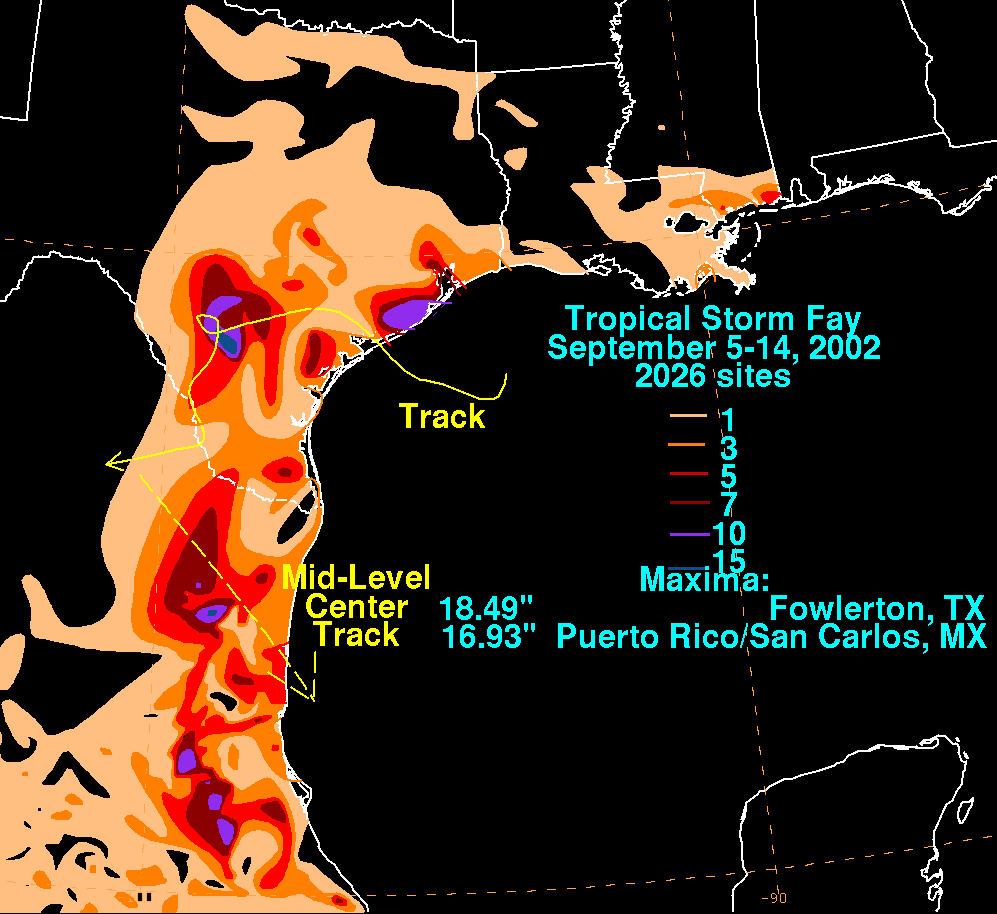
. Storm surge along the Texas coast was 4.5 feet (1.1 m) above the normal high tide. Peak rainfall throughout the area was in the range of 10-15 inches (250–380 mm). Severe damage resulted from Fay in Sweeny
, where about 1,000 homes and businesses were damaged by the storm, and there was $3.5 million (2002 USD; $4.1 million 2007 USD) in damage. Rainfall totals up to 24 inches (600 mm) caused severe flash flooding there, and in areas near there. Another area that received severe damage from Fay was Matagorda County, where flooding from the storm left $1.3 million (2002 USD; $1.5 million 2007 USD) in damage to roads and public facilities.
Twelve tornadoes were reported during Fay's landfall; the most notable one destroyed a mobile home, and damaged a barn. Heavy rain from Fay's remnants also dropped 2–3 inches (50–75 mm) of rain over Frio County. Rainfall of 8 inches (200 mm) was reported near the Atascosca County line with an isolated report of 12 inches (300 mm) in other areas. The rainfall caused severe flashflooding which forced people to flee to roof tops. Damage to buildings, roads and crops totaled up to $800,000 (2002 USD; $940,000 2007 USD).
In Mexico, effects were mostly related to rainfall; up to 16 inches (400 mm) fell in some areas. When Fay flooded areas such as Nuevo Laredo, Tamaulipas, 100 families were evacuated from their homes, and 120 people were stranded in hotels. It is reported that in that town, 10 trees fell causing little or no damage. Also, the Rio Grande
flooded its banks to 3.3 meters (10 ft) above flood stage. It is reported that 300 families were not able to return to their homes for several weeks as a result of the flooding.
(FEMA) had carried out over 2,700 home and building inspections. Non-government relief programs such as The Individual and Family Grant Program had distributed over $400,000 (2002 USD; $469,000 2007 USD) in checks, and over $1 million (2002 USD; $1.2 million 2007 USD) in relief funds. The SBA
also funded over $250,000 (2002 USD; $294,000 2007 USD) in relief aid.
After Tropical Storm Fay, the Internal Revenue Service (IRS) announced that they would apply special tax relief for the nine counties in Texas that were declared disaster areas.
2002 Atlantic hurricane season
The 2002 Atlantic hurricane season was an average Atlantic hurricane season, officially starting on June 1, 2002 and ending on November 30, dates which conventionally limit the period of each year when tropical cyclones in the Atlantic Ocean tend to form...
; it was a moderate tropical storm which caused flooding in parts of Texas
Texas
Texas is the second largest U.S. state by both area and population, and the largest state by area in the contiguous United States.The name, based on the Caddo word "Tejas" meaning "friends" or "allies", was applied by the Spanish to the Caddo themselves and to the region of their settlement in...
and Mexico
Mexico
The United Mexican States , commonly known as Mexico , is a federal constitutional republic in North America. It is bordered on the north by the United States; on the south and west by the Pacific Ocean; on the southeast by Guatemala, Belize, and the Caribbean Sea; and on the east by the Gulf of...
. In early September, a trough of low pressure moved south into the Gulf of Mexico
Gulf of Mexico
The Gulf of Mexico is a partially landlocked ocean basin largely surrounded by the North American continent and the island of Cuba. It is bounded on the northeast, north and northwest by the Gulf Coast of the United States, on the southwest and south by Mexico, and on the southeast by Cuba. In...
, and became stationary. A low pressure center developed along this trough, and on September 5, a Hurricane Hunter airplane reported that the system had gained sufficient organization to be a tropical depression
Tropical cyclone
A tropical cyclone is a storm system characterized by a large low-pressure center and numerous thunderstorms that produce strong winds and heavy rain. Tropical cyclones strengthen when water evaporated from the ocean is released as the saturated air rises, resulting in condensation of water vapor...
, 95 miles (152.9 km) southeast of Galveston
Galveston, Texas
Galveston is a coastal city located on Galveston Island in the U.S. state of Texas. , the city had a total population of 47,743 within an area of...
. The depression drifted south-southwest while strengthening, reaching its peak strength of 60 mi/h on the morning of September 6. The system then made an abrupt turn to the west-northwest, and remained steady in strength and course until landfall the next day, near Matagorda
Matagorda
Matagorda may refer to:Geography*Matagorda Bay, on the coast of Texas*Matagorda County, Texas*Matagorda Independent School District in Matagorda County, Texas*Matagorda Island, a barrier island on the coast of Texas...
. The system weakened at a fast rate after landfall, but its circulation would not totally dissipate for three more days.
The storm caused extremely heavy rainfall in inland areas; damage totalled $4.5 million (2002 USD; $5.2 million USD in 2007); no deaths occurred as a result of Fay.
Meteorological history
In the first few days of September 2002, an upper-level troughTrough (meteorology)
A trough is an elongated region of relatively low atmospheric pressure, often associated with fronts.Unlike fronts, there is not a universal symbol for a trough on a weather chart. The weather charts in some countries or regions mark troughs by a line. In the United States, a trough may be marked...
emerged in the Gulf of Mexico and stalled. Thunderstorms developed along the trough and concentrated around a weak low pressure
Low pressure area
A low-pressure area, or "low", is a region where the atmospheric pressure at sea level is below that of surrounding locations. Low-pressure systems form under areas of wind divergence which occur in upper levels of the troposphere. The formation process of a low-pressure area is known as...
system. Gradually, the trough and associated low pressure drifted south into the warm waters of the Gulf of Mexico. A low pressure area in the northwest Gulf of Mexico became the dominant circulation and slowly developed persistent convection near the center. On September 5, a reconnaissance aircraft investigated the system. During the flight, a low-level center became evident and some deep convection persisted; as a result, it was classified as a tropical depression. Wind shear within the Gulf of Mexico was weak and remained favorable to tropical cyclone formation. A reconnaissance flight later that day discovered an ill-defined circulation which led to low confidence of the location of the center of circulation. However, enough convection persisted for the depression to be upgraded into Tropical Storm Fay that evening.
Stationary in movement, the associated convection became removed from the center of circulation; despite this, the system gradually intensified. On September 6, the storm reached its peak intensity of 60 mph (100 km/h). Light wind shear
Wind shear
Wind shear, sometimes referred to as windshear or wind gradient, is a difference in wind speed and direction over a relatively short distance in the atmosphere...
prevented Fay from intensifying further, and the gradual movement was dictated by a weak mid-level ridge to the north. A low pressure system to the south of Fay produced wind shear and resulted in decreased convection on the southern half of the circulation, with the majority of convective activity located on the northern half. Fay soon became disorganized which prompted National Hurricane Center
National Hurricane Center
The National Hurricane Center , located at Florida International University in Miami, Florida, is the division of the National Weather Service responsible for tracking and predicting weather systems within the tropics between the Prime Meridian and the 140th meridian west poleward to the 30th...
forecaster Avila to state, "[Fay] rather resembles a subtropical storm". Fay moved little, and intensified slightly late on September 6.
On September 7, Fay began to drift northwest towards the Texas coast as rainbands reached the northwest portion of the Texas coastline.
Fay accelerated towards the Texas coast and made landfall early on September 7. The storm meandered throughout inland Texas, and as the system moved inland, forward speed decreased and Fay weakened to a tropical depression. The last advisory was issued on Fay on September 7, although the depression persisted for several days just inland of the Texas Coast.
Preparations
Coinciding with the development of the tropical depression, forecasters issued a tropical storm warning for parts of the Texas coast. When the depression was upgraded into Tropical Storm Fay, the warnings were extended from Matagorda, TexasMatagorda, Texas
Matagorda is an unincorporated community in Matagorda County, Texas, United States. It had a population of approximately 710 in 2000. Matagorda is at the end of State Highway 60 and beginning of Farm to Market Road 2031, which runs over the Intracoastal Waterway and south to the Gulf of Mexico...
to coastal Louisiana
Louisiana
Louisiana is a state located in the southern region of the United States of America. Its capital is Baton Rouge and largest city is New Orleans. Louisiana is the only state in the U.S. with political subdivisions termed parishes, which are local governments equivalent to counties...
. On September 8, forecasters extended the warnings to Port Aransas, Texas
Texas
Texas is the second largest U.S. state by both area and population, and the largest state by area in the contiguous United States.The name, based on the Caddo word "Tejas" meaning "friends" or "allies", was applied by the Spanish to the Caddo themselves and to the region of their settlement in...
, and areas from Port O'Connor
Texas
Texas is the second largest U.S. state by both area and population, and the largest state by area in the contiguous United States.The name, based on the Caddo word "Tejas" meaning "friends" or "allies", was applied by the Spanish to the Caddo themselves and to the region of their settlement in...
to High Island, Texas
High Island, Texas
High Island is an unincorporated area located in the Bolivar Peninsula census-designated place, Galveston County, Texas, United States. The community is located in the extreme eastern part of the county on Bolivar Peninsula, less than one mile from Chambers County and less than two miles from...
were put under a hurricane watch as the storm was forecast to reach hurricane strength before making landfall. However, the hurricane watch for those areas were discontinued when Fay failed to reach hurricane strength. In addition, coastal Texas as well as coastal Louisiana
Louisiana
Louisiana is a state located in the southern region of the United States of America. Its capital is Baton Rouge and largest city is New Orleans. Louisiana is the only state in the U.S. with political subdivisions termed parishes, which are local governments equivalent to counties...
were under a coastal flood warning, while parts of inland Texas were under flash flood warning
Flash Flood Warning
A Flash Flood Warning is issued when a flash flood is imminent or occurring in the warned area. A flash flood is a sudden, violent flood after a heavy rain...
s and flood warning
Flood warning
Flood warning is closely linked to the task of flood forecasting. The distinction between the two is that the outcome of flood forecasting is a set of forecast time-profiles of channel flows or river levels at various locations, while "flood warning" is the task of making use of these forecasts to...
s.
Schools closed in Galveston and High Island on September 6 in anticipation of the storm, and voluntary evacuation orders were put in to effect along low-lying coastal areas. Some grocery stores in Angleton
Angleton, Texas
Angleton is a city in and the county seat of Brazoria County, Texas, United States, within the Houston–Sugar Land–Baytown metropolitan area. Angleton lies at the intersection of State Highway 288, State Highway 35, and the Union Pacific Railroad. The population was 18,130 at the 2000 census...
reported supply shortages.
Impact
Mississippi
Mississippi is a U.S. state located in the Southern United States. Jackson is the state capital and largest city. The name of the state derives from the Mississippi River, which flows along its western boundary, whose name comes from the Ojibwe word misi-ziibi...
, effects were minor, and limited to moderate rain up to three inches (76 mm) .
The effects in Texas were moderate to severe in some locations, with flooding being the main source of damage. In total, 400 houses sustained damage from flooding.
Along the coast, a waterspout
Waterspout
A waterspout is an intense columnar vortex that occurs over a body of water and is connected to a cumuliform cloud. In the common form, it is a non-supercell tornado over water. While it is often weaker than most of its land counterparts, stronger versions spawned by mesocyclones do occur...
spawned by Fay made landfall, and caused minor damage along the northern end of Galveston Island
Galveston Island
Galveston Island is a barrier island on the Texas Gulf coast in the United States, about 50 miles southeast of Houston. The entire island, with the exception of Jamaica Beach, is within the city limits of the City of Galveston....
. Storm surge along the Texas coast was 4.5 feet (1.1 m) above the normal high tide. Peak rainfall throughout the area was in the range of 10-15 inches (250–380 mm). Severe damage resulted from Fay in Sweeny
Sweeny, Texas
Sweeny is a city in Brazoria County, Texas, USA. The population was 3,624 at the 2000 census, 7,316 if you include unincorporated areas of Sweeny. The city's motto is "A City With Pride", and is the westernmost incorporated town in the county.-Demographics:...
, where about 1,000 homes and businesses were damaged by the storm, and there was $3.5 million (2002 USD; $4.1 million 2007 USD) in damage. Rainfall totals up to 24 inches (600 mm) caused severe flash flooding there, and in areas near there. Another area that received severe damage from Fay was Matagorda County, where flooding from the storm left $1.3 million (2002 USD; $1.5 million 2007 USD) in damage to roads and public facilities.
Twelve tornadoes were reported during Fay's landfall; the most notable one destroyed a mobile home, and damaged a barn. Heavy rain from Fay's remnants also dropped 2–3 inches (50–75 mm) of rain over Frio County. Rainfall of 8 inches (200 mm) was reported near the Atascosca County line with an isolated report of 12 inches (300 mm) in other areas. The rainfall caused severe flashflooding which forced people to flee to roof tops. Damage to buildings, roads and crops totaled up to $800,000 (2002 USD; $940,000 2007 USD).
In Mexico, effects were mostly related to rainfall; up to 16 inches (400 mm) fell in some areas. When Fay flooded areas such as Nuevo Laredo, Tamaulipas, 100 families were evacuated from their homes, and 120 people were stranded in hotels. It is reported that in that town, 10 trees fell causing little or no damage. Also, the Rio Grande
Rio Grande
The Rio Grande is a river that flows from southwestern Colorado in the United States to the Gulf of Mexico. Along the way it forms part of the Mexico – United States border. Its length varies as its course changes...
flooded its banks to 3.3 meters (10 ft) above flood stage. It is reported that 300 families were not able to return to their homes for several weeks as a result of the flooding.
Aftermath
Nine counties in Texas were declared disaster areas after Tropical Storm Fay: Brazoria, Frio, Galveston, La Salle, Live Oak, Matagorda, Nueces, San Patricio and Wharton. The declaration enabled business owners and residents to apply for federal and state government aid programs. Disaster housing checks handed out after the storm totaled to over $2.7 million (2002 USD; $3.1 million 2007 USD) and the Federal Emergency Management AgencyFederal Emergency Management Agency
The Federal Emergency Management Agency is an agency of the United States Department of Homeland Security, initially created by Presidential Reorganization Plan No. 1 of 1978 and implemented by two Executive Orders...
(FEMA) had carried out over 2,700 home and building inspections. Non-government relief programs such as The Individual and Family Grant Program had distributed over $400,000 (2002 USD; $469,000 2007 USD) in checks, and over $1 million (2002 USD; $1.2 million 2007 USD) in relief funds. The SBA
SBA
SBA may stand for:* Survivable Branch Appliance* Santa Barbara Airport* Santa Barbara Airlines* SBA Towers, radio masts and towers* School-based assessment, a programme of Hong Kong Diploma of Secondary Education which composes parts of the marks...
also funded over $250,000 (2002 USD; $294,000 2007 USD) in relief aid.
After Tropical Storm Fay, the Internal Revenue Service (IRS) announced that they would apply special tax relief for the nine counties in Texas that were declared disaster areas.
See also
- List of Texas hurricanes
- Other storms of the same name