
.gif)
Tropical Storm Chris (2006)
Encyclopedia
Tropical Storm Chris was the fourth tropical storm
of the 2006 Atlantic hurricane season
. Forming on July 31 in the Atlantic Ocean
east of the Leeward Islands
from a tropical wave
, Chris moved generally to the west-northwest, skirting the northern fringes of the Caribbean
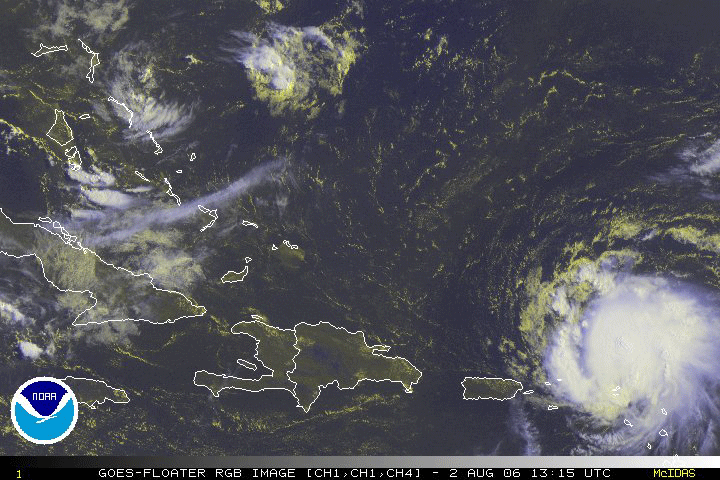
islands. Chris was a relatively short-lived storm, reaching a peak intensity with winds at 65 mph (100 km/h) on August 2, while positioned north of St. Martin. The storm gradually weakened before finally dissipating on August 5, near eastern Cuba
. Overall impact was minimal, amounting to moderate amounts of rainfall throughout its path. No deaths were reported.
moved westward off the coast of Africa
on July 27. Initially, virgorous convection persisted throughout the wave axis, though dry air greatly diminished the convection on July 28. The wind field remained well-defined as it continued westward, and deep convection increased two days later along the northern end of the wave axis. Dvorak classifications
began on July 30 in response to an increase in vertical depth and organization of the convection. On July 31 a buoy
recorded a change of wind direction from northeast to west, indicating a small low pressure area
formed. Convective organization rapidly increased as it turned to the northwest, and the system developed into Tropical Depression Three on August 1 while located about 235 miles (375 km) east-southeast of Barbuda
.
Forecasters initially predicted wind shear
from an upper level low would prevent strengthening and cause dissipation within three days. However, the depression continued to organize as deep convection continued to develop near the circulation despite moderate amounts of wind shear, and the system intensified into Tropical Storm Chris six hours after developing. The convection gradually consolidated over the system, and by late on the 1st Chris reached winds of 60 mph (95 km/h) while passing 50 miles (80 km) north of the northern Leeward Islands
. The structure of Chris continued to improve and become more symmetrical, and an upper level eye
feature developed early on August 2. Outflow improved in all quadrants, as well, and the storm reached a peak intensity of 65 mph (100 km/h) shortly thereafter while located 120 miles (195 km) east of St. Thomas
. Despite initial predictions of Chris intensifying to a hurricane as a ridge
of high pressure forced it west-northwestward, upper level shear dissipated the well-defined inner core of the storm, and Chris started to weaken.
 Early on August 3, strong wind shear over Chris detached the deep convection from the low level circulation, while a building ridge
to its north turned the storm towards the west into an area of drier air. By mid-day on the 3rd the circulation was devoid of any convection within 85 miles (135 km), while the deeper convection spread across Puerto Rico
and Hispaniola
. Late on August 3, deep convection developed over the center of circulation again, though persistent vertical shear weakened Chris to a tropical depression on August 4. Due to computer models
predicting lesser amounts of shear, forecasters indicated the possibility of moderate strengthening in the Gulf of Mexico
to a 60 mph (95 km/h) storm. However, convection remained minimal, and Chris degenerated into a remnant area of low pressure late on August 4. Late on August 5, convection increased in the remnants of the storm, and forecasters indicated the potential for slow development over the Gulf of Mexico due to marginally favorable conditions. Redevelopment never occurred, and the remnant circulation dissipated near Havana, Cuba on August 6.
 When the National Hurricane Center
issued its first advisory on Tropical Depression Three, the governments of Antigua and Barbuda
, Anguilla
, Saint Kitts and Nevis
, and the British Virgin Islands
issued a Tropical Storm Warning
for their respective territories. When the depression strengthened to Tropical Storm Chris, Tropical Storm Warnings were also issued for Saba, Sint Eustatius, Saint-Barthélemy, and Saint Martin
. Three Royal Caribbean
cruise ships re-routed their paths to avoid the storm. Federal Emergency Management Agency
(FEMA) representatives coordinated with local emergency management officials in the United States Virgin Islands
to determine if preparation necessities would be adequate, such as hospital usage, shelters, and sand bags.
On August 1, officials in Puerto Rico
issued a tropical storm warning for the island. The next day, approximately 600 tourists evacuated the islands of Vieques
and Culebra
. On August 2, the government of the Bahamas issued a Hurricane Watch for the Turks and Caicos Islands
, the Acklins and Crooked Islands
, Ragged Island, Inagua
, and Mayaguana
. In response to the threat, officials urged citizens to stock up on hurricane supplies, while boat owners in Staniel Cay secured their boats in preparation for the storm.
In response to the storm's projected path into the Gulf of Mexico
, prices for crude oil rose on the New York Mercantile Exchange
at branch offices in London
. Natural gas
prices rose considerably in New York Mercantile Exchange electronic trading on August 2. Anticipation of a threat to supply by a potential Hurricane Chris coupled with high demand during an ongoing heat wave
were cited as factors in the price move. In New Orleans
, officials including Mayor Ray Nagin
prepared for a possible evacuation of the city if Chris entered the Gulf of Mexico
as a hurricane. The evacuation plan included moving all residents out of the city as a worst-case scenario, intended to avoid a re-occurrence of Hurricane Katrina
around one year prior. Florida Emergency Management requested ten mobile recovery centers, and placed hospitals in the Florida Keys
on standby for evacuation. Officials in Mississippi
identified the need for 110 to assist in an evacuation process in case of a possible landfall. Both Louisiana and Texas
emergency operation centers monitored the progress of the storm, though did not execute any preparation action.
 Despite its initial threat, Chris caused little impact in the Lesser Antilles
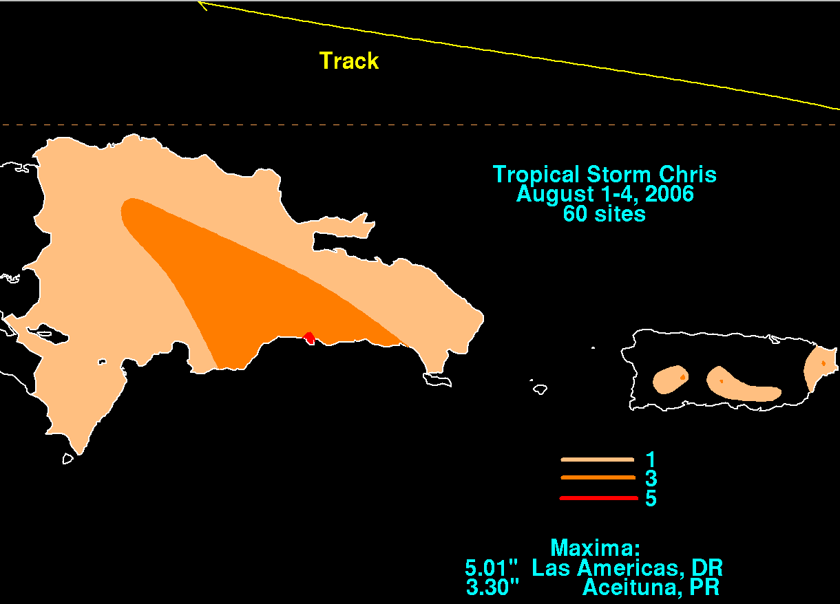
. Overall damage from Chris was minimal. The storm dropped light rainfall in Puerto Rico, peaking at 3.09 inches (78 mm) in Fajardo. The rainfall from the storm caused the Fajardo River to overflow its banks, which temporarily closed a highway in the northeastern portion of the island.
Rainfall reached up to 2 inches (50 mm
) across portions of Hispaniola
, the Turks and Caicos, the Bahamas, and eastern Cuba
, and reached 4 inches (100 mm) in some mountainous areas. In Santo Domingo
in the Dominican Republic
, heavy rainfall caused severe flooding. Las Américas reported 5.01 inches (127 mm) of rainfall from Chris. Several people were left temporarily homeless due to flooding entering their households. The flooding left many roads impassable near the capital city, and also resulted in landslides. The flooding also covered rice fields in the northeastern portion of the country. The National Office of Meteorology issued flood warnings for residents in low-lying areas and near rivers in the northeast and southeast portions of the country. Despite the flooding, overall damage was minor, and there are no casualties associated with Chris.
National Hurricane Center's archive on Tropical Storm Chris
Tropical cyclone
A tropical cyclone is a storm system characterized by a large low-pressure center and numerous thunderstorms that produce strong winds and heavy rain. Tropical cyclones strengthen when water evaporated from the ocean is released as the saturated air rises, resulting in condensation of water vapor...
of the 2006 Atlantic hurricane season
2006 Atlantic hurricane season
The 2006 Atlantic hurricane season was significantly less active than the record previous season. It marked the first since 2001 in which no hurricanes made landfall in the United States, and was the first since 1994 that no tropical cyclones formed during October. Following the intense activity of...
. Forming on July 31 in the Atlantic Ocean
Atlantic Ocean
The Atlantic Ocean is the second-largest of the world's oceanic divisions. With a total area of about , it covers approximately 20% of the Earth's surface and about 26% of its water surface area...
east of the Leeward Islands
Leeward Islands
The Leeward Islands are a group of islands in the West Indies. They are the northern islands of the Lesser Antilles chain. As a group they start east of Puerto Rico and reach southward to Dominica. They are situated where the northeastern Caribbean Sea meets the western Atlantic Ocean...
from a tropical wave
Tropical wave
Tropical waves, easterly waves, or tropical easterly waves, also known as African easterly waves in the Atlantic region, are a type of atmospheric trough, an elongated area of relatively low air pressure, oriented north to south, which move from east to west across the tropics causing areas of...
, Chris moved generally to the west-northwest, skirting the northern fringes of the Caribbean
Caribbean
The Caribbean is a crescent-shaped group of islands more than 2,000 miles long separating the Gulf of Mexico and the Caribbean Sea, to the west and south, from the Atlantic Ocean, to the east and north...
islands. Chris was a relatively short-lived storm, reaching a peak intensity with winds at 65 mph (100 km/h) on August 2, while positioned north of St. Martin. The storm gradually weakened before finally dissipating on August 5, near eastern Cuba
Cuba
The Republic of Cuba is an island nation in the Caribbean. The nation of Cuba consists of the main island of Cuba, the Isla de la Juventud, and several archipelagos. Havana is the largest city in Cuba and the country's capital. Santiago de Cuba is the second largest city...
. Overall impact was minimal, amounting to moderate amounts of rainfall throughout its path. No deaths were reported.
Meteorological history
A tropical waveTropical wave
Tropical waves, easterly waves, or tropical easterly waves, also known as African easterly waves in the Atlantic region, are a type of atmospheric trough, an elongated area of relatively low air pressure, oriented north to south, which move from east to west across the tropics causing areas of...
moved westward off the coast of Africa
Africa
Africa is the world's second largest and second most populous continent, after Asia. At about 30.2 million km² including adjacent islands, it covers 6% of the Earth's total surface area and 20.4% of the total land area...
on July 27. Initially, virgorous convection persisted throughout the wave axis, though dry air greatly diminished the convection on July 28. The wind field remained well-defined as it continued westward, and deep convection increased two days later along the northern end of the wave axis. Dvorak classifications
Dvorak technique
The Dvorak technique is a widely used system to subjectively estimate tropical cyclone intensity based solely on visible and infrared satellite images. Several agencies issue Dvorak intensity numbers for cyclones of sufficient intensity...
began on July 30 in response to an increase in vertical depth and organization of the convection. On July 31 a buoy
Buoy
A buoy is a floating device that can have many different purposes. It can be anchored or allowed to drift. The word, of Old French or Middle Dutch origin, is now most commonly in UK English, although some orthoepists have traditionally prescribed the pronunciation...
recorded a change of wind direction from northeast to west, indicating a small low pressure area
Low pressure area
A low-pressure area, or "low", is a region where the atmospheric pressure at sea level is below that of surrounding locations. Low-pressure systems form under areas of wind divergence which occur in upper levels of the troposphere. The formation process of a low-pressure area is known as...
formed. Convective organization rapidly increased as it turned to the northwest, and the system developed into Tropical Depression Three on August 1 while located about 235 miles (375 km) east-southeast of Barbuda
Barbuda
Barbuda is an island in the Eastern Caribbean, and forms part of the state of Antigua and Barbuda. It has a population of about 1,500, most of whom live in the town of Codrington.-Location:...
.
Forecasters initially predicted wind shear
Wind shear
Wind shear, sometimes referred to as windshear or wind gradient, is a difference in wind speed and direction over a relatively short distance in the atmosphere...
from an upper level low would prevent strengthening and cause dissipation within three days. However, the depression continued to organize as deep convection continued to develop near the circulation despite moderate amounts of wind shear, and the system intensified into Tropical Storm Chris six hours after developing. The convection gradually consolidated over the system, and by late on the 1st Chris reached winds of 60 mph (95 km/h) while passing 50 miles (80 km) north of the northern Leeward Islands
Leeward Islands
The Leeward Islands are a group of islands in the West Indies. They are the northern islands of the Lesser Antilles chain. As a group they start east of Puerto Rico and reach southward to Dominica. They are situated where the northeastern Caribbean Sea meets the western Atlantic Ocean...
. The structure of Chris continued to improve and become more symmetrical, and an upper level eye
Eye (cyclone)
The eye is a region of mostly calm weather found at the center of strong tropical cyclones. The eye of a storm is a roughly circular area and typically 30–65 km in diameter. It is surrounded by the eyewall, a ring of towering thunderstorms where the second most severe weather of a cyclone...
feature developed early on August 2. Outflow improved in all quadrants, as well, and the storm reached a peak intensity of 65 mph (100 km/h) shortly thereafter while located 120 miles (195 km) east of St. Thomas
Saint Thomas, U.S. Virgin Islands
Saint Thomas is an island in the Caribbean Sea and with the islands of Saint John, Saint Croix, and Water Island a county and constituent district of the United States Virgin Islands , an unincorporated territory of the United States. Located on the island is the territorial capital and port of...
. Despite initial predictions of Chris intensifying to a hurricane as a ridge
Ridge (meteorology)
A ridge is an elongated region of relatively high atmospheric pressure, the opposite of a trough....
of high pressure forced it west-northwestward, upper level shear dissipated the well-defined inner core of the storm, and Chris started to weaken.
Ridge (meteorology)
A ridge is an elongated region of relatively high atmospheric pressure, the opposite of a trough....
to its north turned the storm towards the west into an area of drier air. By mid-day on the 3rd the circulation was devoid of any convection within 85 miles (135 km), while the deeper convection spread across Puerto Rico
Puerto Rico
Puerto Rico , officially the Commonwealth of Puerto Rico , is an unincorporated territory of the United States, located in the northeastern Caribbean, east of the Dominican Republic and west of both the United States Virgin Islands and the British Virgin Islands.Puerto Rico comprises an...
and Hispaniola
Hispaniola
Hispaniola is a major island in the Caribbean, containing the two sovereign states of the Dominican Republic and Haiti. The island is located between the islands of Cuba to the west and Puerto Rico to the east, within the hurricane belt...
. Late on August 3, deep convection developed over the center of circulation again, though persistent vertical shear weakened Chris to a tropical depression on August 4. Due to computer models
Weather forecasting
Weather forecasting is the application of science and technology to predict the state of the atmosphere for a given location. Human beings have attempted to predict the weather informally for millennia, and formally since the nineteenth century...
predicting lesser amounts of shear, forecasters indicated the possibility of moderate strengthening in the Gulf of Mexico
Gulf of Mexico
The Gulf of Mexico is a partially landlocked ocean basin largely surrounded by the North American continent and the island of Cuba. It is bounded on the northeast, north and northwest by the Gulf Coast of the United States, on the southwest and south by Mexico, and on the southeast by Cuba. In...
to a 60 mph (95 km/h) storm. However, convection remained minimal, and Chris degenerated into a remnant area of low pressure late on August 4. Late on August 5, convection increased in the remnants of the storm, and forecasters indicated the potential for slow development over the Gulf of Mexico due to marginally favorable conditions. Redevelopment never occurred, and the remnant circulation dissipated near Havana, Cuba on August 6.
Preparations
National Hurricane Center
The National Hurricane Center , located at Florida International University in Miami, Florida, is the division of the National Weather Service responsible for tracking and predicting weather systems within the tropics between the Prime Meridian and the 140th meridian west poleward to the 30th...
issued its first advisory on Tropical Depression Three, the governments of Antigua and Barbuda
Antigua and Barbuda
Antigua and Barbuda is a twin-island nation lying between the Caribbean Sea and the Atlantic Ocean. It consists of two major inhabited islands, Antigua and Barbuda, and a number of smaller islands...
, Anguilla
Anguilla
Anguilla is a British overseas territory and overseas territory of the European Union in the Caribbean. It is one of the most northerly of the Leeward Islands in the Lesser Antilles, lying east of Puerto Rico and the Virgin Islands and directly north of Saint Martin...
, Saint Kitts and Nevis
Saint Kitts and Nevis
The Federation of Saint Kitts and Nevis , located in the Leeward Islands, is a federal two-island nation in the West Indies. It is the smallest sovereign state in the Americas, in both area and population....
, and the British Virgin Islands
British Virgin Islands
The Virgin Islands, often called the British Virgin Islands , is a British overseas territory and overseas territory of the European Union, located in the Caribbean to the east of Puerto Rico. The islands make up part of the Virgin Islands archipelago, the remaining islands constituting the U.S...
issued a Tropical Storm Warning
Tropical cyclone warnings and watches
Warnings and watches are two levels of alert issued by national weather forecasting bodies to coastal areas threatened by the imminent approach of a tropical cyclone of tropical storm or hurricane intensity. They are notices to the local population and civil authorities to make appropriate...
for their respective territories. When the depression strengthened to Tropical Storm Chris, Tropical Storm Warnings were also issued for Saba, Sint Eustatius, Saint-Barthélemy, and Saint Martin
Saint Martin
Saint Martin is an island in the northeast Caribbean, approximately east of Puerto Rico. The 87 km2 island is divided roughly 60/40 between France and the Kingdom of the Netherlands ; however, the Dutch side has the larger population. It is one of the smallest sea islands divided between...
. Three Royal Caribbean
Royal Caribbean International
Royal Caribbean International is a Norwegian and American cruise line brand based in Miami, Florida and owned by Royal Caribbean Cruises Ltd.. With 42 ships in service under 5 different brands and one more under construction, it controls a 25.6% share of the world cruise market...
cruise ships re-routed their paths to avoid the storm. Federal Emergency Management Agency
Federal Emergency Management Agency
The Federal Emergency Management Agency is an agency of the United States Department of Homeland Security, initially created by Presidential Reorganization Plan No. 1 of 1978 and implemented by two Executive Orders...
(FEMA) representatives coordinated with local emergency management officials in the United States Virgin Islands
United States Virgin Islands
The Virgin Islands of the United States are a group of islands in the Caribbean that are an insular area of the United States. The islands are geographically part of the Virgin Islands archipelago and are located in the Leeward Islands of the Lesser Antilles.The U.S...
to determine if preparation necessities would be adequate, such as hospital usage, shelters, and sand bags.
On August 1, officials in Puerto Rico
Puerto Rico
Puerto Rico , officially the Commonwealth of Puerto Rico , is an unincorporated territory of the United States, located in the northeastern Caribbean, east of the Dominican Republic and west of both the United States Virgin Islands and the British Virgin Islands.Puerto Rico comprises an...
issued a tropical storm warning for the island. The next day, approximately 600 tourists evacuated the islands of Vieques
Vieques, Puerto Rico
Vieques , in full Isla de Vieques, is an island–municipality of Puerto Rico in the northeastern Caribbean, part of an island grouping sometimes known as the Spanish Virgin Islands...
and Culebra
Culebra, Puerto Rico
Isla Culebra is an island-municipality of Puerto Rico originally called Isla Pasaje and Isla de San Ildefonso. It is located approximately east of the Puerto Rican mainland, west of St. Thomas and north of Vieques. Culebra is spread over 5 wards and Culebra Pueblo...
. On August 2, the government of the Bahamas issued a Hurricane Watch for the Turks and Caicos Islands
Turks and Caicos Islands
The Turks and Caicos Islands are a British Overseas Territory and overseas territory of the European Union consisting of two groups of tropical islands in the Caribbean, the larger Caicos Islands and the smaller Turks Islands, known for tourism and as an offshore financial centre.The Turks and...
, the Acklins and Crooked Islands
Acklins and Crooked Islands
Acklins and Crooked Islands was a district of the Bahamas until 1996, and as Acklins, Crooked Island and Long Cay until 1999....
, Ragged Island, Inagua
Inagua
Inagua is the southernmost district of the Bahamas comprising the islands of Great Inagua and Little Inagua.Great Inagua is the third largest island in The Bahamas at 596 sq mi and lies about 55 miles from the eastern tip of Cuba. The island is about 55 x 19 miles in extent, the highest point...
, and Mayaguana
Mayaguana
Mayaguana is the most easterly island and district of the Bahamas. It is one of only a few Bahamian islands which retain their Lucayan names. The population of Mayaguana in the 2000 census was 259, amounting to an estimate 312 in 2010...
. In response to the threat, officials urged citizens to stock up on hurricane supplies, while boat owners in Staniel Cay secured their boats in preparation for the storm.
In response to the storm's projected path into the Gulf of Mexico
Gulf of Mexico
The Gulf of Mexico is a partially landlocked ocean basin largely surrounded by the North American continent and the island of Cuba. It is bounded on the northeast, north and northwest by the Gulf Coast of the United States, on the southwest and south by Mexico, and on the southeast by Cuba. In...
, prices for crude oil rose on the New York Mercantile Exchange
New York Mercantile Exchange
The New York Mercantile Exchange is the world's largest physical commodity futures exchange. It is located at One North End Avenue in the World Financial Center in the Battery Park City section of Manhattan, New York City...
at branch offices in London
London
London is the capital city of :England and the :United Kingdom, the largest metropolitan area in the United Kingdom, and the largest urban zone in the European Union by most measures. Located on the River Thames, London has been a major settlement for two millennia, its history going back to its...
. Natural gas
Natural gas
Natural gas is a naturally occurring gas mixture consisting primarily of methane, typically with 0–20% higher hydrocarbons . It is found associated with other hydrocarbon fuel, in coal beds, as methane clathrates, and is an important fuel source and a major feedstock for fertilizers.Most natural...
prices rose considerably in New York Mercantile Exchange electronic trading on August 2. Anticipation of a threat to supply by a potential Hurricane Chris coupled with high demand during an ongoing heat wave
2006 North American heat wave
The 2006 North American heat wave spread throughout most of the United States and Canada beginning on July 15, 2006, killing at least 225 people. That day the temperature reached 117 °F in Pierre, South Dakota, with many places in South Dakota that hit well into the 120s. A 130 degree...
were cited as factors in the price move. In New Orleans
New Orleans, Louisiana
New Orleans is a major United States port and the largest city and metropolitan area in the state of Louisiana. The New Orleans metropolitan area has a population of 1,235,650 as of 2009, the 46th largest in the USA. The New Orleans – Metairie – Bogalusa combined statistical area has a population...
, officials including Mayor Ray Nagin
Ray Nagin
Clarence Ray Nagin, Jr. is a former mayor of New Orleans, Louisiana, United States. Nagin gained international note in 2005 in the aftermath of Hurricane Katrina, which devastated the New Orleans area....
prepared for a possible evacuation of the city if Chris entered the Gulf of Mexico
Gulf of Mexico
The Gulf of Mexico is a partially landlocked ocean basin largely surrounded by the North American continent and the island of Cuba. It is bounded on the northeast, north and northwest by the Gulf Coast of the United States, on the southwest and south by Mexico, and on the southeast by Cuba. In...
as a hurricane. The evacuation plan included moving all residents out of the city as a worst-case scenario, intended to avoid a re-occurrence of Hurricane Katrina
Hurricane Katrina
Hurricane Katrina of the 2005 Atlantic hurricane season was a powerful Atlantic hurricane. It is the costliest natural disaster, as well as one of the five deadliest hurricanes, in the history of the United States. Among recorded Atlantic hurricanes, it was the sixth strongest overall...
around one year prior. Florida Emergency Management requested ten mobile recovery centers, and placed hospitals in the Florida Keys
Florida Keys
The Florida Keys are a coral archipelago in southeast United States. They begin at the southeastern tip of the Florida peninsula, about south of Miami, and extend in a gentle arc south-southwest and then westward to Key West, the westernmost of the inhabited islands, and on to the uninhabited Dry...
on standby for evacuation. Officials in Mississippi
Mississippi
Mississippi is a U.S. state located in the Southern United States. Jackson is the state capital and largest city. The name of the state derives from the Mississippi River, which flows along its western boundary, whose name comes from the Ojibwe word misi-ziibi...
identified the need for 110 to assist in an evacuation process in case of a possible landfall. Both Louisiana and Texas
Texas
Texas is the second largest U.S. state by both area and population, and the largest state by area in the contiguous United States.The name, based on the Caddo word "Tejas" meaning "friends" or "allies", was applied by the Spanish to the Caddo themselves and to the region of their settlement in...
emergency operation centers monitored the progress of the storm, though did not execute any preparation action.
Impact
Lesser Antilles
The Lesser Antilles are a long, partly volcanic island arc in the Western Hemisphere. Most of its islands form the eastern boundary of the Caribbean Sea with the Atlantic Ocean, with the remainder located in the southern Caribbean just north of South America...
. Overall damage from Chris was minimal. The storm dropped light rainfall in Puerto Rico, peaking at 3.09 inches (78 mm) in Fajardo. The rainfall from the storm caused the Fajardo River to overflow its banks, which temporarily closed a highway in the northeastern portion of the island.
Rainfall reached up to 2 inches (50 mm
Millimetre
The millimetre is a unit of length in the metric system, equal to one thousandth of a metre, which is the SI base unit of length....
) across portions of Hispaniola
Hispaniola
Hispaniola is a major island in the Caribbean, containing the two sovereign states of the Dominican Republic and Haiti. The island is located between the islands of Cuba to the west and Puerto Rico to the east, within the hurricane belt...
, the Turks and Caicos, the Bahamas, and eastern Cuba
Cuba
The Republic of Cuba is an island nation in the Caribbean. The nation of Cuba consists of the main island of Cuba, the Isla de la Juventud, and several archipelagos. Havana is the largest city in Cuba and the country's capital. Santiago de Cuba is the second largest city...
, and reached 4 inches (100 mm) in some mountainous areas. In Santo Domingo
Santo Domingo
Santo Domingo, known officially as Santo Domingo de Guzmán, is the capital and largest city in the Dominican Republic. Its metropolitan population was 2,084,852 in 2003, and estimated at 3,294,385 in 2010. The city is located on the Caribbean Sea, at the mouth of the Ozama River...
in the Dominican Republic
Dominican Republic
The Dominican Republic is a nation on the island of La Hispaniola, part of the Greater Antilles archipelago in the Caribbean region. The western third of the island is occupied by the nation of Haiti, making Hispaniola one of two Caribbean islands that are shared by two countries...
, heavy rainfall caused severe flooding. Las Américas reported 5.01 inches (127 mm) of rainfall from Chris. Several people were left temporarily homeless due to flooding entering their households. The flooding left many roads impassable near the capital city, and also resulted in landslides. The flooding also covered rice fields in the northeastern portion of the country. The National Office of Meteorology issued flood warnings for residents in low-lying areas and near rivers in the northeast and southeast portions of the country. Despite the flooding, overall damage was minor, and there are no casualties associated with Chris.
See also
- Other tropical cyclones of the same name