

Transport in Belfast
Encyclopedia
Transportation systems in the city of Belfast
, Northern Ireland
include road, air, rail, and sea. It is still a relatively car dependent city however it is also served by a comprehensive rail and bus network. Belfast also ran electric tram
s prior to 1954. The city has two major airports and the Port of Belfast
is the busiest ferry port in Ireland
.
city of Belfast, transport consisted of horse-drawn carts on cobbled streets. Some of these streets in the Cathedral Quarter
are still cobbled. As the city expanded rapidly during the Industrial Revolution
, the need grew for public transport
to carry workers in and out of the city. The Belfast Street Tramway Company replaced carts with horse-drawn trams and the Cavehill and Whitewell Tramway company ran a steam tramway from the outlying villages of Whitewell and Glengormley
into Belfast. Belfast Zoo
was created in 1934 from Bellevue Gardens, a playground and pleasure gardens at the end of the Cavehill line. In 1905, the Belfast Corporation took over and electrified the city's tram network. The trams were partially replaced by trolleybuses
from 1938, and finally replaced by buses in 1954.
Recent developments have been proposed in the The Belfast Metropolitan Transport Plan (BMTP), launched by the Minister for Regional Development in November 2004. It aimed to set a new direction for transport in the city following decades of under-investment.
. These walls were erected by the British Army
, after August 1969, at the beginning of the Troubles
. They were built in an effort to deal with the nightly rioting in the city at the time, and to stop intimidation and population flight. There was very little community consultation throughout this process.
Since the 1970s, the inner city numbers have dropped and the Greater Belfast
suburb population has grown. As with many cities, Belfast's inner city is currently characterised by the elderly, students and single young people, while families tend to live on the periphery. Socio-economic areas radiate out from the Central Business District, with a pronounced wedge of affluence extending out the Malone Road to the south. An area of greater deprivation extends to the west of the city. In fact the areas around the Falls and Shankill Roads are the most deprived wards in Northern Ireland.
Some important arterial routes into Belfast include:
The most significant road scheme in Belfast for some years began early in 2006, with the upgrading of two junctions along the Westlink
dual carriageway to grade separated
standard. The Westlink, a dual carriageway skirting the western edge of the City Centre, connects all three Belfast motorways and has suffered from chronic congestion for some years. The work will cost £103.9 million and is scheduled for completion in 2009. Some commentators have argued that this may simply create a new bottleneck at the at-grade
York Street intersection until that too is converted to a fully free-flowing grade separated junction, currently scheduled to take place between 2011 and 2016.
The Lagan and Lough Cycle Way, part of the National Cycle Network
, runs through the city centre along the Laganside promenade and linking north to Jordanstown through the docks and along the lough shore and south-west to Lisburn along the Lagan towpath.
. A recent survey of how people travel in Northern Ireland showed that people in Belfast made 77% of all journeys by car, 11% by public transport and 6% on foot. It also showed that Belfast has 0.70 cars per household compared to figures of 1.18 in the East and 1.14 in the West of Northern Ireland.
A significant road improvement scheme in Belfast began early in 2006, with the upgrading of two junctions along the Westlink
dual carriageway to grade separated
standard. The Westlink, a dual carriageway skirting the western edge of the City Centre, connects all three Belfast motorways and often suffers from chronic congestion. The work will cost GB£
103.9 million and is scheduled for completion in 2009. Commentators have argued that this may simply create a new bottleneck at York Street, the next at-grade intersection
, until that too is upgraded (planned for 2011).
Most public transport in Northern Ireland is operated by the subsidiaries of Translink
. Bus services in the city proper and the nearer suburbs are operated by Translink Metro
, with services focusing on linking residential districts with the City Centre on twelve quality bus corridor
s running along main radial roads, resulting in poor connections between different suburban areas. More distant suburbs are served by Ulsterbus
.
Black taxis
are common in the city, operating on a share
basis in some areas. Separate associations serving nationalist and unionist areas operate throughout Belfast. During the Troubles
, nationalist taxi drivers in West Belfast and Ardoyne
became targets for loyalist assassination campaigns. Today black taxis take tourists on tours of the city's sectarian murals
. They are now outnumbered by private hire minicabs.
offers domestic, European and transatlantic flights and is located north of the city, near Lough Neagh
while the George Best Belfast City Airport
is closer to the city centre, adjacent to Belfast Lough. In 2005, Belfast International Airport was the 11th busiest commercial airport in the UK, accounting for just over 2% of all UK terminal passengers while the George Best Belfast City Airport was the 16th busiest and had 1% of UK terminal passengers.
in Northern Ireland is operated by subsidiaries of Translink
. Bus services in the city proper and the nearer suburbs are operated by Translink Metro
, with services focusing on linking residential districts with the City Centre on twelve quality bus corridor
s running along main radial roads, resulting in poor connections between different suburban areas. More distant suburbs are served by Ulsterbus
.
Northern Ireland Railways
provides suburban services
along three lines running through Belfast’s northern suburbs to Carrickfergus
and Larne
, eastwards towards Bangor
and south-westwards towards Lisburn
and Portadown
. This service is known as the Belfast Suburban Rail
system.
Northern Ireland Railways
is the sole public railway operator in Northern Ireland. The network serving Greater Belfast
is known as Belfast Suburban Rail
and is owned by Translink
. These provide rail services along four major routes:
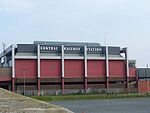 Some important rail stations in Belfast include Belfast Central
, Great Victoria Street
, Botanic
, City Hospital
, Yorkgate
. The Enterprise is a cross-border inter-city train service between Dublin Connolly
in the Republic of Ireland
and Belfast Central
in Northern Ireland
. It is jointly operated by Iarnród Éireann
(IE) and Northern Ireland Railways
(NIR).
In January 2007, it was revealed that a feasibility study is being carried out, to construct a light rail system in the city, initially along two routes, eventually along four. It has been compared to Luas
, the tram
system in Dublin.
These proposals include:
In 2008, the Department for Regional Development issued a report suggesting that a "high class bus-based network could cut commuting times while costing significantly less".
, used for exporting and importing goods and for passenger ferry services. Stena Line
run regular services to Stranraer
in Scotland using their HSS (High Speed Service) vessel, with a crossing time of around ninety minutes, and/or their conventional vessel with a crossing time of around three hours and forty-five minutes. Norfolkline
(formally Norse Merchant Ferries) run a passenger/cargo ferry to and from Liverpool
, with a crossing time of eight hours and a seasonal sailing to Douglas, Isle of Man
is operated by the Isle of Man Steam Packet
company (formally SeaCat
).
The natural inlet of Belfast Lough
gives Belfast its own port
. As the city developed, this became the major avenue for trade with Britain and later Europe
and North America
. In the mid-seventeenth century, Belfast exported beef, butter, hides, tallow and corn and it imported coal, cloth, wine, brandy, paper, timber and tobacco. At the beginning of the eighteenth century, Belfast's significant trade made it the richest commercial town in the north of Ireland. Around this time, the linen
trade in Northern Ireland blossomed and by the middle of the eighteenth century, one fifth of all the linen exported from Ireland was shipped from Belfast Harbour.
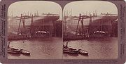 As the Industrial Revolution
arrived, the port provided the outlet for the thriving linen and shipbuilding trades. Belfast harbour was dredged in 1845 to provide deeper berths for larger ships. Donegall Quay was built out into the river as the harbour was developed further and trade flourished. The Harland and Wolff
shipbuilding
firm was created in 1861 and by the time the Titanic was built in Belfast in 1912, they boasted the largest shipyard in the world.
It is also the biggest gateway for both the import and export of goods in Northern Ireland
, receiving 6,000 vessels, and half a million freight units per year. The Harbour Estate is also Northern Ireland's leading logistics & distribution hub.
Belfast
Belfast is the capital of and largest city in Northern Ireland. By population, it is the 14th biggest city in the United Kingdom and second biggest on the island of Ireland . It is the seat of the devolved government and legislative Northern Ireland Assembly...
, Northern Ireland
Northern Ireland
Northern Ireland is one of the four countries of the United Kingdom. Situated in the north-east of the island of Ireland, it shares a border with the Republic of Ireland to the south and west...
include road, air, rail, and sea. It is still a relatively car dependent city however it is also served by a comprehensive rail and bus network. Belfast also ran electric tram
Tram
A tram is a passenger rail vehicle which runs on tracks along public urban streets and also sometimes on separate rights of way. It may also run between cities and/or towns , and/or partially grade separated even in the cities...
s prior to 1954. The city has two major airports and the Port of Belfast
Port of Belfast
Belfast Harbour is a major maritime gateway in Northern Ireland, serving the Northern Ireland economy and increasingly that of the Republic of Ireland...
is the busiest ferry port in Ireland
Ireland
Ireland is an island to the northwest of continental Europe. It is the third-largest island in Europe and the twentieth-largest island on Earth...
.
History
In the VictorianVictorian era
The Victorian era of British history was the period of Queen Victoria's reign from 20 June 1837 until her death on 22 January 1901. It was a long period of peace, prosperity, refined sensibilities and national self-confidence...
city of Belfast, transport consisted of horse-drawn carts on cobbled streets. Some of these streets in the Cathedral Quarter
Cathedral Quarter, Belfast
The Cathedral Quarter in Belfast, Northern Ireland is a developing area of the city, roughly situated between Royal Avenue near where the Belfast Central Library building is, and the Dunbar Link in the city centre. From one of its corners, the junction of Royal Avenue, Donegall Street and York...
are still cobbled. As the city expanded rapidly during the Industrial Revolution
Industrial Revolution
The Industrial Revolution was a period from the 18th to the 19th century where major changes in agriculture, manufacturing, mining, transportation, and technology had a profound effect on the social, economic and cultural conditions of the times...
, the need grew for public transport
Public transport
Public transport is a shared passenger transportation service which is available for use by the general public, as distinct from modes such as taxicab, car pooling or hired buses which are not shared by strangers without private arrangement.Public transport modes include buses, trolleybuses, trams...
to carry workers in and out of the city. The Belfast Street Tramway Company replaced carts with horse-drawn trams and the Cavehill and Whitewell Tramway company ran a steam tramway from the outlying villages of Whitewell and Glengormley
Glengormley
Glengormley or Glengormly is the name of a townland and electoral ward in County Antrim, Northern Ireland. Glengormley is within the urban area called Newtownabbey and the wider Newtownabbey Borough.-Location:...
into Belfast. Belfast Zoo
Belfast Zoo
Belfast Zoological Gardens is a zoo in Belfast, Northern Ireland. It is located in a relatively secluded location on the northeastern slope of Cavehill, overlooking Belfast's Antrim Road, resulting in a uniquely tranquil environment for the animals that the zoo is frequently praised for.-About the...
was created in 1934 from Bellevue Gardens, a playground and pleasure gardens at the end of the Cavehill line. In 1905, the Belfast Corporation took over and electrified the city's tram network. The trams were partially replaced by trolleybuses
Trolleybuses in Belfast
The Belfast trolleybus system once served the city of Belfast, Northern Ireland. It was the only trolleybus system ever to be built in Ireland. Opened on , it gradually replaced the Belfast tramway network....
from 1938, and finally replaced by buses in 1954.
Recent developments have been proposed in the The Belfast Metropolitan Transport Plan (BMTP), launched by the Minister for Regional Development in November 2004. It aimed to set a new direction for transport in the city following decades of under-investment.
City layout
Belfast remains a divided city. There are 14 neighborhoods in the inner-city of Belfast which are divided by peace linesPeace lines
The peace lines or peace walls are a series of separation barriers in Northern Ireland that separate Catholic and Protestant neighbourhoods. They have been built at urban interface areas in Belfast, Derry, Portadown and elsewhere...
. These walls were erected by the British Army
British Army
The British Army is the land warfare branch of Her Majesty's Armed Forces in the United Kingdom. It came into being with the unification of the Kingdom of England and Scotland into the Kingdom of Great Britain in 1707. The new British Army incorporated Regiments that had already existed in England...
, after August 1969, at the beginning of the Troubles
The Troubles
The Troubles was a period of ethno-political conflict in Northern Ireland which spilled over at various times into England, the Republic of Ireland, and mainland Europe. The duration of the Troubles is conventionally dated from the late 1960s and considered by many to have ended with the Belfast...
. They were built in an effort to deal with the nightly rioting in the city at the time, and to stop intimidation and population flight. There was very little community consultation throughout this process.
Since the 1970s, the inner city numbers have dropped and the Greater Belfast
Greater Belfast
Greater Belfast is an area surrounding and including Belfast in Northern Ireland.It includes Belfast and parts of the North Down, Lisburn, Castlereagh and Newtownabbey district council areas. Greater Belfast is the largest urban area in Northern Ireland, and second largest in Ireland...
suburb population has grown. As with many cities, Belfast's inner city is currently characterised by the elderly, students and single young people, while families tend to live on the periphery. Socio-economic areas radiate out from the Central Business District, with a pronounced wedge of affluence extending out the Malone Road to the south. An area of greater deprivation extends to the west of the city. In fact the areas around the Falls and Shankill Roads are the most deprived wards in Northern Ireland.
Some important arterial routes into Belfast include:
- York Street/York Road/Shore Road
- Antrim Road
- Oldpark Road
- Crumlin RoadCrumlin RoadThe Crumlin Road is a main road in north-west Belfast, Northern Ireland. The road runs from north of Belfast City Centre for about four miles to the outskirts of the city. It also forms part of the longer A52 road.-Lower Crumlin Road:...
- Shankill Road/Woodvale Road/Ballygomartin Road
- Divis Street/Falls Road/Glen Road
- Grosvenor Road/Springfield Road
- Andersonstown Road/Stewartstown Road
- Donegall RoadDonegall RoadThe Donegall Road runs from Shaftesbury Square in Belfast city centre to the Falls Road in west Belfast. It is bisected by the Westlink, and the largest part of the road, prior to the Westlink junction, is predominantly unionist...
- Lisburn RoadLisburn RoadThe Lisburn Road is a main arterial road linking Belfast and Lisburn, in Northern Ireland.The Lisburn Road is now an extension of the "Golden Mile" with many shops, boutiques, wine bars, restaurants and coffee houses. The road runs almost parallel to the Malone Road, the two being joined by many...
- University Road/Malone RoadMalone RoadThe Malone Road is a radial road in Belfast, Northern Ireland, leading from the university quarter southwards to the affluent suburbs of Malone and Upper Malone, each a separate electoral ward...
- Ormeau Road
- Ravenhill Road
- Woodstock Link/Woodstock Road/Cregagh Road
- Castlereagh Street/Castlereagh Road
- Albertbridge Road
- Newtownards Road/Upper Newtownards Road
- Holywood Road
The most significant road scheme in Belfast for some years began early in 2006, with the upgrading of two junctions along the Westlink
Westlink Belfast
The Westlink road in Belfast, Northern Ireland is a dual carriageway throughpass, designated the A12, connecting the M1 to the M2 and M3 motorways which run south, north and east of the city, respectively...
dual carriageway to grade separated
Grade separation
Grade separation is the method of aligning a junction of two or more transport axes at different heights so that they will not disrupt the traffic flow on other transit routes when they cross each other. The composition of such transport axes does not have to be uniform; it can consist of a...
standard. The Westlink, a dual carriageway skirting the western edge of the City Centre, connects all three Belfast motorways and has suffered from chronic congestion for some years. The work will cost £103.9 million and is scheduled for completion in 2009. Some commentators have argued that this may simply create a new bottleneck at the at-grade
At-grade intersection
An at-grade intersection is a junction at which two or more transport axes cross at the same level .-Traffic management:With areas of high or fast traffic, an at-grade intersection normally requires a traffic control device such as a stop sign, traffic light or railway signal to manage conflicting...
York Street intersection until that too is converted to a fully free-flowing grade separated junction, currently scheduled to take place between 2011 and 2016.
The Lagan and Lough Cycle Way, part of the National Cycle Network
National Cycle Network
The National Cycle Network is a network of cycle routes in the United Kingdom.The National Cycle Network was created by the charity Sustrans , and aided by a £42.5 million National Lottery grant. In 2005 it was used for over 230 million trips.Many routes hope to minimise contact with motor...
, runs through the city centre along the Laganside promenade and linking north to Jordanstown through the docks and along the lough shore and south-west to Lisburn along the Lagan towpath.
Cars and buses
Belfast is a relatively car-dependent city, by European standards, with an extensive road network including the ten lane M2 motorwayM2 motorway (Northern Ireland)
The M2 is a motorway in Belfast and County Antrim in Northern Ireland. It is in two sections, the southern section running from north Belfast to Antrim and the northern section acts as a bypass of Ballymena, with the A26 road linking the two sections. In total it is 22 miles...
. A recent survey of how people travel in Northern Ireland showed that people in Belfast made 77% of all journeys by car, 11% by public transport and 6% on foot. It also showed that Belfast has 0.70 cars per household compared to figures of 1.18 in the East and 1.14 in the West of Northern Ireland.
A significant road improvement scheme in Belfast began early in 2006, with the upgrading of two junctions along the Westlink
Westlink Belfast
The Westlink road in Belfast, Northern Ireland is a dual carriageway throughpass, designated the A12, connecting the M1 to the M2 and M3 motorways which run south, north and east of the city, respectively...
dual carriageway to grade separated
Grade separation
Grade separation is the method of aligning a junction of two or more transport axes at different heights so that they will not disrupt the traffic flow on other transit routes when they cross each other. The composition of such transport axes does not have to be uniform; it can consist of a...
standard. The Westlink, a dual carriageway skirting the western edge of the City Centre, connects all three Belfast motorways and often suffers from chronic congestion. The work will cost GB£
Pound sterling
The pound sterling , commonly called the pound, is the official currency of the United Kingdom, its Crown Dependencies and the British Overseas Territories of South Georgia and the South Sandwich Islands, British Antarctic Territory and Tristan da Cunha. It is subdivided into 100 pence...
103.9 million and is scheduled for completion in 2009. Commentators have argued that this may simply create a new bottleneck at York Street, the next at-grade intersection
At-grade intersection
An at-grade intersection is a junction at which two or more transport axes cross at the same level .-Traffic management:With areas of high or fast traffic, an at-grade intersection normally requires a traffic control device such as a stop sign, traffic light or railway signal to manage conflicting...
, until that too is upgraded (planned for 2011).
Most public transport in Northern Ireland is operated by the subsidiaries of Translink
Translink (Northern Ireland)
Translink is the brand name of the Northern Ireland Transport Holding Company , a public corporation in Northern Ireland which provides the public transport in the region. NI Railways, Ulsterbus and Metro are all part of Translink....
. Bus services in the city proper and the nearer suburbs are operated by Translink Metro
Metro (Belfast)
Metro is the trading name for bus company Citybus in Belfast, Northern Ireland. It is a subsidiary of the Northern Ireland Transport Holding Company, within the common management structure of Translink, along with Ulsterbus and Northern Ireland Railways....
, with services focusing on linking residential districts with the City Centre on twelve quality bus corridor
Quality Bus Corridor
Quality Bus Corridors are an initiative to give dedicated road space and traffic signal priority to buses in Dublin, Ireland in order to reduce journey times and improve service consistency. The aim of the initiative is to encourage people to change from cars to buses and thus reduce traffic...
s running along main radial roads, resulting in poor connections between different suburban areas. More distant suburbs are served by Ulsterbus
Ulsterbus
Ulsterbus is a public transport operator in Northern Ireland and operates bus services outside Belfast. It is part of Translink , which also includes Northern Ireland Railways, Metro Belfast and Flexibus.-Services:Ulsterbus is responsible for most of the province-wide bus...
.
Black taxis
Hackney carriage
A hackney or hackney carriage is a carriage or automobile for hire...
are common in the city, operating on a share
Share taxi
A share taxi is a mode of transport that falls between taxis and conventional buses. These informal vehicles for hire are found throughout the world. They are smaller than buses, and usually take passengers on a fixed or semi-fixed route without timetables, usually leaving when all seats are filled...
basis in some areas. Separate associations serving nationalist and unionist areas operate throughout Belfast. During the Troubles
The Troubles
The Troubles was a period of ethno-political conflict in Northern Ireland which spilled over at various times into England, the Republic of Ireland, and mainland Europe. The duration of the Troubles is conventionally dated from the late 1960s and considered by many to have ended with the Belfast...
, nationalist taxi drivers in West Belfast and Ardoyne
Ardoyne
Ardoyne is an Irish nationalist, working class and mainly Catholic district in north Belfast, Northern Ireland. It gained notoriety due to the large number of incidents during "The Troubles". It is home to approximately 20,000 inhabitants...
became targets for loyalist assassination campaigns. Today black taxis take tourists on tours of the city's sectarian murals
Northern Irish murals
Murals in Northern Ireland have become symbols of Northern Ireland, depicting the region's past and present political and religious divisions.Northern Ireland contains arguably the most famous political murals. Almost 2,000 murals have been documented in Northern Ireland since the 1970s...
. They are now outnumbered by private hire minicabs.
Airports
The city has two airports: The Belfast International AirportBelfast International Airport
Belfast International Airport is a major airport located northwest of Belfast in Northern Ireland. It was formerly known and is still referred to as Aldergrove Airport, after the village of the same name lying immediately to the west of the airport. Belfast International shares its runways with...
offers domestic, European and transatlantic flights and is located north of the city, near Lough Neagh
Lough Neagh
Lough Neagh, sometimes Loch Neagh, is a large freshwater lake in Northern Ireland. Its name comes .-Geography:With an area of , it is the largest lake in the British Isles and ranks among the forty largest lakes of Europe. Located twenty miles to the west of Belfast, it is approximately twenty...
while the George Best Belfast City Airport
George Best Belfast City Airport
George Best Belfast City Airport is a single-runway airport in Belfast, County Antrim, Northern Ireland. Situated adjacent to the Port of Belfast it is from Belfast City Centre. It shares the site with the Short Brothers/Bombardier aircraft manufacturing facility...
is closer to the city centre, adjacent to Belfast Lough. In 2005, Belfast International Airport was the 11th busiest commercial airport in the UK, accounting for just over 2% of all UK terminal passengers while the George Best Belfast City Airport was the 16th busiest and had 1% of UK terminal passengers.
- The Belfast International AirportBelfast International AirportBelfast International Airport is a major airport located northwest of Belfast in Northern Ireland. It was formerly known and is still referred to as Aldergrove Airport, after the village of the same name lying immediately to the west of the airport. Belfast International shares its runways with...
Aldergrove offers domestic, European and transatlantic flights and is located 21 kilometres northwest of the city, near Lough NeaghLough NeaghLough Neagh, sometimes Loch Neagh, is a large freshwater lake in Northern Ireland. Its name comes .-Geography:With an area of , it is the largest lake in the British Isles and ranks among the forty largest lakes of Europe. Located twenty miles to the west of Belfast, it is approximately twenty...
. It was opened in 1917 as a training establishment for the Royal Flying CorpsRoyal Flying CorpsThe Royal Flying Corps was the over-land air arm of the British military during most of the First World War. During the early part of the war, the RFC's responsibilities were centred on support of the British Army, via artillery co-operation and photographic reconnaissance...
during the First World WarWorld War IWorld War I , which was predominantly called the World War or the Great War from its occurrence until 1939, and the First World War or World War I thereafter, was a major war centred in Europe that began on 28 July 1914 and lasted until 11 November 1918...
. A new Executive Aviation Terminal was opened in 1987 and annual passenger numbers reached 4.5 million in 2004. In 2005, it was the 11th busiest commercial airport in the UK, accounting for just over 2% of all UK terminal passengers. - The George Best Belfast City AirportGeorge Best Belfast City AirportGeorge Best Belfast City Airport is a single-runway airport in Belfast, County Antrim, Northern Ireland. Situated adjacent to the Port of Belfast it is from Belfast City Centre. It shares the site with the Short Brothers/Bombardier aircraft manufacturing facility...
, named after the city's most famous footballing son, is closer to the city centre, beside Belfast LoughBelfast LoughBelfast Lough is a large, natural intertidal sea lough at the mouth of the River Lagan on the east coast of Northern Ireland. The inner part of the lough comprises a series of mudflats and lagoons. The outer lough is restricted to mainly rocky shores with some small sandy bays...
. Previously named the Harbour Airport, it was opened on 16 March 1938 by Anne ChamberlainAnne ChamberlainAnne Vere Chamberlain, née Anne de Vere Cole was the wife of British Prime Minister Neville Chamberlain.Chamberlain was born to Major William Utting Cole, of West Woodhay House; he died in India of cholera while she was young...
, the wife of the British Prime MinisterNeville ChamberlainArthur Neville Chamberlain FRS was a British Conservative politician who served as Prime Minister of the United Kingdom from May 1937 to May 1940. Chamberlain is best known for his appeasement foreign policy, and in particular for his signing of the Munich Agreement in 1938, conceding the...
at the time. It opened to passenger flights in 1983 and opened a new passenger terminal in 2001. The airport was officially renamed after George BestGeorge BestGeorge Best was a professional footballer from Northern Ireland, who played for Manchester United and the Northern Ireland national team. He was a winger whose game combined pace, acceleration, balance, two-footedness, goalscoring and the ability to beat defenders...
on 22 May 2006, the day he would have celebrated his 60th birthday. In 2005, it was the 16th busiest airport in the UK and had 1% of all UK terminal passengers.
Railways
Bus and rail public transportPublic transport
Public transport is a shared passenger transportation service which is available for use by the general public, as distinct from modes such as taxicab, car pooling or hired buses which are not shared by strangers without private arrangement.Public transport modes include buses, trolleybuses, trams...
in Northern Ireland is operated by subsidiaries of Translink
Translink (Northern Ireland)
Translink is the brand name of the Northern Ireland Transport Holding Company , a public corporation in Northern Ireland which provides the public transport in the region. NI Railways, Ulsterbus and Metro are all part of Translink....
. Bus services in the city proper and the nearer suburbs are operated by Translink Metro
Metro (Belfast)
Metro is the trading name for bus company Citybus in Belfast, Northern Ireland. It is a subsidiary of the Northern Ireland Transport Holding Company, within the common management structure of Translink, along with Ulsterbus and Northern Ireland Railways....
, with services focusing on linking residential districts with the City Centre on twelve quality bus corridor
Quality Bus Corridor
Quality Bus Corridors are an initiative to give dedicated road space and traffic signal priority to buses in Dublin, Ireland in order to reduce journey times and improve service consistency. The aim of the initiative is to encourage people to change from cars to buses and thus reduce traffic...
s running along main radial roads, resulting in poor connections between different suburban areas. More distant suburbs are served by Ulsterbus
Ulsterbus
Ulsterbus is a public transport operator in Northern Ireland and operates bus services outside Belfast. It is part of Translink , which also includes Northern Ireland Railways, Metro Belfast and Flexibus.-Services:Ulsterbus is responsible for most of the province-wide bus...
.
Northern Ireland Railways
Northern Ireland Railways
NI Railways, also known as Northern Ireland Railways and for a brief period of time, Ulster Transport Railways , is the railway operator in Northern Ireland...
provides suburban services
Belfast Suburban Rail
The Belfast Suburban Rail commuter network serves the metropolitan area of Greater Belfast and some of its commuter towns with three lines. The network is owned by Translink and operated by Northern Ireland Railways ....
along three lines running through Belfast’s northern suburbs to Carrickfergus
Carrickfergus
Carrickfergus , known locally and colloquially as "Carrick", is a large town in County Antrim, Northern Ireland. It is located on the north shore of Belfast Lough, from Belfast. The town had a population of 27,201 at the 2001 Census and takes its name from Fergus Mór mac Eirc, the 6th century king...
and Larne
Larne
Larne is a substantial seaport and industrial market town on the east coast of County Antrim, Northern Ireland with a population of 18,228 people in the 2001 Census. As of 2011, there are about 31,000 residents in the greater Larne area. It has been used as a seaport for over 1,000 years, and is...
, eastwards towards Bangor
Bangor, County Down
Bangor is a large town in County Down, Northern Ireland. It is a seaside resort on the southern side of Belfast Lough and within the Belfast Metropolitan Area. Bangor Marina is one of the largest in Ireland, and holds Blue Flag status...
and south-westwards towards Lisburn
Lisburn
DemographicsLisburn Urban Area is within Belfast Metropolitan Urban Area and is classified as a Large Town by the . On census day there were 71,465 people living in Lisburn...
and Portadown
Portadown
Portadown is a town in County Armagh, Northern Ireland. The town sits on the River Bann in the north of the county, about 23 miles south-west of Belfast...
. This service is known as the Belfast Suburban Rail
Belfast Suburban Rail
The Belfast Suburban Rail commuter network serves the metropolitan area of Greater Belfast and some of its commuter towns with three lines. The network is owned by Translink and operated by Northern Ireland Railways ....
system.
Northern Ireland Railways
Northern Ireland Railways
NI Railways, also known as Northern Ireland Railways and for a brief period of time, Ulster Transport Railways , is the railway operator in Northern Ireland...
is the sole public railway operator in Northern Ireland. The network serving Greater Belfast
Greater Belfast
Greater Belfast is an area surrounding and including Belfast in Northern Ireland.It includes Belfast and parts of the North Down, Lisburn, Castlereagh and Newtownabbey district council areas. Greater Belfast is the largest urban area in Northern Ireland, and second largest in Ireland...
is known as Belfast Suburban Rail
Belfast Suburban Rail
The Belfast Suburban Rail commuter network serves the metropolitan area of Greater Belfast and some of its commuter towns with three lines. The network is owned by Translink and operated by Northern Ireland Railways ....
and is owned by Translink
Translink (Northern Ireland)
Translink is the brand name of the Northern Ireland Transport Holding Company , a public corporation in Northern Ireland which provides the public transport in the region. NI Railways, Ulsterbus and Metro are all part of Translink....
. These provide rail services along four major routes:
- Belfast-Larne railway line runs through Belfast’s northern suburbs to CarrickfergusCarrickfergusCarrickfergus , known locally and colloquially as "Carrick", is a large town in County Antrim, Northern Ireland. It is located on the north shore of Belfast Lough, from Belfast. The town had a population of 27,201 at the 2001 Census and takes its name from Fergus Mór mac Eirc, the 6th century king...
and LarneLarneLarne is a substantial seaport and industrial market town on the east coast of County Antrim, Northern Ireland with a population of 18,228 people in the 2001 Census. As of 2011, there are about 31,000 residents in the greater Larne area. It has been used as a seaport for over 1,000 years, and is... - Belfast-Bangor railway line runs eastwards towards BangorBangor, County DownBangor is a large town in County Down, Northern Ireland. It is a seaside resort on the southern side of Belfast Lough and within the Belfast Metropolitan Area. Bangor Marina is one of the largest in Ireland, and holds Blue Flag status...
- Belfast-Newry railway line and south-westwards through LisburnLisburnDemographicsLisburn Urban Area is within Belfast Metropolitan Urban Area and is classified as a Large Town by the . On census day there were 71,465 people living in Lisburn...
and PortadownPortadownPortadown is a town in County Armagh, Northern Ireland. The town sits on the River Bann in the north of the county, about 23 miles south-west of Belfast...
to NewryNewryNewry is a city in Northern Ireland. The River Clanrye, which runs through the city, formed the historic border between County Armagh and County Down. It is from Belfast and from Dublin. Newry had a population of 27,433 at the 2001 Census, while Newry and Mourne Council Area had a population... - Belfast-Derry railway line and north eastern through AntrimAntrim, County AntrimAntrim is a town in County Antrim in the northeast of Northern Ireland, on the banks of the Six Mile Water, half a mile north-east of Lough Neagh. It had a population of 20,001 people in the 2001 Census. The town is the administrative centre of Antrim Borough Council...
and ColeraineColeraineColeraine is a large town near the mouth of the River Bann in County Londonderry, Northern Ireland. It is northwest of Belfast and east of Derry, both of which are linked by major roads and railway connections...
to DerryDerryDerry or Londonderry is the second-biggest city in Northern Ireland and the fourth-biggest city on the island of Ireland. The name Derry is an anglicisation of the Irish name Doire or Doire Cholmcille meaning "oak-wood of Colmcille"...
Belfast Central railway station
Belfast Central is a railway station serving the city of Belfast in County Antrim, Northern Ireland. It is one of the four stations located in Belfast City Centre, the others being Great Victoria Street, City Hospital and Botanic....
, Great Victoria Street
Belfast Great Victoria Street railway station
Belfast Great Victoria Street is a major railway station serving the city centre of Belfast, Northern Ireland. It is one of two major stations in the city, along with , and is one of the four stations located in the city centre, the others being Belfast Central, and . It is near Great Victoria...
, Botanic
Botanic railway station
.Botanic railway station serves the Botanic area in south Belfast, Northern Ireland and students for Queen's University Belfast. It is named after the nearby Belfast Botanic Gardens...
, City Hospital
City Hospital railway station
City Hospital railway station serves Belfast City Hospital and the surrounding area of south Belfast, Northern Ireland. It is one of the four stations located in the city centre, the others being Great Victoria Street, Botanic, and Central....
, Yorkgate
Yorkgate railway station
Yorkgate railway station serves the north of the city of Belfast, Northern Ireland. The station opened in 1992, replacing the previous York Road station nearby.-York Road Railway Station:...
. The Enterprise is a cross-border inter-city train service between Dublin Connolly
Dublin Connolly railway station
Dublin Connolly, commonly called Connolly station , is one of the main railway stations in Dublin, Ireland, and is a focal point in the Irish route network. Opened in 1844 as Amiens Street Station, the ornate facade has a distinctive Italianate tower at its centre...
in the Republic of Ireland
Republic of Ireland
Ireland , described as the Republic of Ireland , is a sovereign state in Europe occupying approximately five-sixths of the island of the same name. Its capital is Dublin. Ireland, which had a population of 4.58 million in 2011, is a constitutional republic governed as a parliamentary democracy,...
and Belfast Central
Belfast Central railway station
Belfast Central is a railway station serving the city of Belfast in County Antrim, Northern Ireland. It is one of the four stations located in Belfast City Centre, the others being Great Victoria Street, City Hospital and Botanic....
in Northern Ireland
Northern Ireland
Northern Ireland is one of the four countries of the United Kingdom. Situated in the north-east of the island of Ireland, it shares a border with the Republic of Ireland to the south and west...
. It is jointly operated by Iarnród Éireann
Iarnród Éireann
Iarnród Éireann is the national railway system operator of Ireland. Established on 2 February 1987, it is a subsidiary of Córas Iompair Éireann . It operates all internal intercity, commuter and freight railway services in the Republic of Ireland, and, jointly with Northern Ireland Railways, the...
(IE) and Northern Ireland Railways
Northern Ireland Railways
NI Railways, also known as Northern Ireland Railways and for a brief period of time, Ulster Transport Railways , is the railway operator in Northern Ireland...
(NIR).
In January 2007, it was revealed that a feasibility study is being carried out, to construct a light rail system in the city, initially along two routes, eventually along four. It has been compared to Luas
Luas
Luas , also promoted in the development stage as the Dublin Light Rail System, is a tram or light rail system serving Dublin, the first such system in the decades since the closure of the last of the Dublin tramways. In 2007, the system carried 28.4 million passengers, a growth of 10% since...
, the tram
Tram
A tram is a passenger rail vehicle which runs on tracks along public urban streets and also sometimes on separate rights of way. It may also run between cities and/or towns , and/or partially grade separated even in the cities...
system in Dublin.
These proposals include:
- EWAYEWAYThe EWAY is a light rail or bus system proposed for East Belfast, Northern Ireland.In January 2007, then Regional Development Minister in Northern Ireland, David Cairns, announced that engineering consultants WS Atkins PLC were to undertake economic feasibility studies on rapid transit proposals...
- East of city and DundonaldDundonaldDundonald is a large settlement in County Down, Northern Ireland. It lies east of Belfast and is often deemed to be a suburb of the city. It includes the large housing estate of Ballybeen, and many new housing estates have emerged in the past ten years.... - WWAYWWAY BelfastThe WWAY is a light-rail system proposed for west Belfast in Northern Ireland.----See:*List of light-rail transit systems...
- West of city - CITICITI BelfastThe CITI was a proposed light-rail system that would have served the under-construction Titanic Quarter and George Best Belfast City Airport in Belfast, Northern Ireland. A report revealed that there were not enough people in the city to justify the project, instead using buses to save costs....
- Titanic QuarterTitanic Quarter, BelfastThe Titanic Quarter in Belfast, Northern Ireland is a waterfront regeneration project, including apartments, a riverside entertainment district, and a major Titanic-themed attraction under development on reclaimed land in Belfast Harbour, known until recently as Queen's Island...
and George Best Belfast City AirportGeorge Best Belfast City AirportGeorge Best Belfast City Airport is a single-runway airport in Belfast, County Antrim, Northern Ireland. Situated adjacent to the Port of Belfast it is from Belfast City Centre. It shares the site with the Short Brothers/Bombardier aircraft manufacturing facility... - SupeRoute - South of City
In 2008, the Department for Regional Development issued a report suggesting that a "high class bus-based network could cut commuting times while costing significantly less".
Seaport
The Port of Belfast is the busiest ferry port in Ireland with over 1.2 million passengers annually. Belfast also has a large portPort of Belfast
Belfast Harbour is a major maritime gateway in Northern Ireland, serving the Northern Ireland economy and increasingly that of the Republic of Ireland...
, used for exporting and importing goods and for passenger ferry services. Stena Line
Stena Line
Stena Line is one of the world's largest ferry operators, with ferry services serving Scotland, Sweden, Northern Ireland, Denmark, Norway, England, Wales, Ireland, Germany, the Netherlands and Poland. Stena Line is a major unit of Stena AB, itself a part of the Stena Sphere, a grouping of Stena AB,...
run regular services to Stranraer
Stranraer
Stranraer is a town in the southwest of Scotland. It lies in the west of Dumfries and Galloway and in the county of Wigtownshire.Stranraer lies on the shores of Loch Ryan on the northern side of the isthmus joining the Rhins of Galloway to the mainland...
in Scotland using their HSS (High Speed Service) vessel, with a crossing time of around ninety minutes, and/or their conventional vessel with a crossing time of around three hours and forty-five minutes. Norfolkline
Norfolkline
Norfolkline was a European ferry operator and logistics company owned by Maersk. It provided freight ferry services on the English channel, Irish Sea, and the North Sea; and passenger ferry services on the English channel and Irish Sea; and logistics services across Europe...
(formally Norse Merchant Ferries) run a passenger/cargo ferry to and from Liverpool
Liverpool
Liverpool is a city and metropolitan borough of Merseyside, England, along the eastern side of the Mersey Estuary. It was founded as a borough in 1207 and was granted city status in 1880...
, with a crossing time of eight hours and a seasonal sailing to Douglas, Isle of Man
Douglas, Isle of Man
right|thumb|250px|Douglas Promenade, which runs nearly the entire length of beachfront in Douglasright|thumb|250px|Sea terminal in DouglasDouglas is the capital and largest town of the Isle of Man, with a population of 26,218 people . It is located at the mouth of the River Douglas, and a sweeping...
is operated by the Isle of Man Steam Packet
Isle of Man Steam Packet
The Isle of Man Steam Packet Company Limited is the oldest continuously operating passenger shipping company in the world, celebrating its 180th anniversary in 2010....
company (formally SeaCat
SeaCat
SeaCat was the marketing name used by Sea Containers Ferries Scotland for its services between Northern Ireland, Scotland and England between 1992 and 2004. The company was originally based in Stranraer later moving to Belfast...
).
The natural inlet of Belfast Lough
Belfast Lough
Belfast Lough is a large, natural intertidal sea lough at the mouth of the River Lagan on the east coast of Northern Ireland. The inner part of the lough comprises a series of mudflats and lagoons. The outer lough is restricted to mainly rocky shores with some small sandy bays...
gives Belfast its own port
Port of Belfast
Belfast Harbour is a major maritime gateway in Northern Ireland, serving the Northern Ireland economy and increasingly that of the Republic of Ireland...
. As the city developed, this became the major avenue for trade with Britain and later Europe
Europe
Europe is, by convention, one of the world's seven continents. Comprising the westernmost peninsula of Eurasia, Europe is generally 'divided' from Asia to its east by the watershed divides of the Ural and Caucasus Mountains, the Ural River, the Caspian and Black Seas, and the waterways connecting...
and North America
North America
North America is a continent wholly within the Northern Hemisphere and almost wholly within the Western Hemisphere. It is also considered a northern subcontinent of the Americas...
. In the mid-seventeenth century, Belfast exported beef, butter, hides, tallow and corn and it imported coal, cloth, wine, brandy, paper, timber and tobacco. At the beginning of the eighteenth century, Belfast's significant trade made it the richest commercial town in the north of Ireland. Around this time, the linen
Linen
Linen is a textile made from the fibers of the flax plant, Linum usitatissimum. Linen is labor-intensive to manufacture, but when it is made into garments, it is valued for its exceptional coolness and freshness in hot weather....
trade in Northern Ireland blossomed and by the middle of the eighteenth century, one fifth of all the linen exported from Ireland was shipped from Belfast Harbour.
Industrial Revolution
The Industrial Revolution was a period from the 18th to the 19th century where major changes in agriculture, manufacturing, mining, transportation, and technology had a profound effect on the social, economic and cultural conditions of the times...
arrived, the port provided the outlet for the thriving linen and shipbuilding trades. Belfast harbour was dredged in 1845 to provide deeper berths for larger ships. Donegall Quay was built out into the river as the harbour was developed further and trade flourished. The Harland and Wolff
Harland and Wolff
Harland and Wolff Heavy Industries is a Northern Irish heavy industrial company, specialising in shipbuilding and offshore construction, located in Belfast, Northern Ireland....
shipbuilding
Shipbuilding
Shipbuilding is the construction of ships and floating vessels. It normally takes place in a specialized facility known as a shipyard. Shipbuilders, also called shipwrights, follow a specialized occupation that traces its roots to before recorded history.Shipbuilding and ship repairs, both...
firm was created in 1861 and by the time the Titanic was built in Belfast in 1912, they boasted the largest shipyard in the world.
It is also the biggest gateway for both the import and export of goods in Northern Ireland
Northern Ireland
Northern Ireland is one of the four countries of the United Kingdom. Situated in the north-east of the island of Ireland, it shares a border with the Republic of Ireland to the south and west...
, receiving 6,000 vessels, and half a million freight units per year. The Harbour Estate is also Northern Ireland's leading logistics & distribution hub.