

Trail of the Ancients
Encyclopedia
The Trail of the Ancients is an National Scenic Byway
located in the states of Colorado
and Utah
. The route highlights the archaeological and cultural history of southwestern
Native American
peoples, and traverses the widely diverse geological landscape of the Four Corners region. The entire route is approximately 480 miles (772.5 km) long.
.
National Scenic Byway
A National Scenic Byway is a road recognized by the United States Department of Transportation for its archeological, cultural, historic, natural, recreational, and/or scenic qualities. The program was established by Congress in 1991 to preserve and protect the nation's scenic but often...
located in the states of Colorado
Colorado
Colorado is a U.S. state that encompasses much of the Rocky Mountains as well as the northeastern portion of the Colorado Plateau and the western edge of the Great Plains...
and Utah
Utah
Utah is a state in the Western United States. It was the 45th state to join the Union, on January 4, 1896. Approximately 80% of Utah's 2,763,885 people live along the Wasatch Front, centering on Salt Lake City. This leaves vast expanses of the state nearly uninhabited, making the population the...
. The route highlights the archaeological and cultural history of southwestern
Southwestern United States
The Southwestern United States is a region defined in different ways by different sources. Broad definitions include nearly a quarter of the United States, including Arizona, California, Colorado, Nevada, New Mexico, Oklahoma, Texas and Utah...
Native American
Native Americans in the United States
Native Americans in the United States are the indigenous peoples in North America within the boundaries of the present-day continental United States, parts of Alaska, and the island state of Hawaii. They are composed of numerous, distinct tribes, states, and ethnic groups, many of which survive as...
peoples, and traverses the widely diverse geological landscape of the Four Corners region. The entire route is approximately 480 miles (772.5 km) long.
Four Corners to Mesa Verde
| Begin | Highway | Directions | Photo | Comments |
|---|---|---|---|---|
| Four Corners Monument Four Corners Monument The Four Corners Monument marks the quadripoint in the Southwestern United States where the states of Arizona, Colorado, New Mexico and Utah meet. It is the only point in the United States shared by four states, leading to this area being called the Four Corners region... |
U.S. Route 160 U.S. Route 160 U.S. Route 160 is a 1,465 mile long east–west United States highway in the Midwestern United States. The western terminus of the route is at U.S. Route 89 five miles west of Tuba City, Arizona. The eastern terminus is at U.S... |
Travel northeast along U.S. Route 160 U.S. Route 160 U.S. Route 160 is a 1,465 mile long east–west United States highway in the Midwestern United States. The western terminus of the route is at U.S. Route 89 five miles west of Tuba City, Arizona. The eastern terminus is at U.S... , crossing the San Juan River, for a total of 19 miles until the byway merges with U.S. Route 491 U.S. Route 491 U.S. Route 491 is a north–south U.S. Highway serving the Four Corners region of the United States. One of the newest designations in the U.S. Highway System, it was created in 2003 as a renumbering of U.S. Route 666... . |
Four Corners, the only quadripoint Quadripoint A quadripoint is a point on the Earth that touches the border of four distinct territories. The term has never been in common use—it may not have been used before 1964, by the Geographer of the United States... in the United States United States The United States of America is a federal constitutional republic comprising fifty states and a federal district... , is also the border between the Navajo Nation Navajo Nation The Navajo Nation is a semi-autonomous Native American-governed territory covering , occupying all of northeastern Arizona, the southeastern portion of Utah, and northwestern New Mexico... (in the states of Utah, Arizona Arizona Arizona ; is a state located in the southwestern region of the United States. It is also part of the western United States and the mountain west. The capital and largest city is Phoenix... , and New Mexico New Mexico New Mexico is a state located in the southwest and western regions of the United States. New Mexico is also usually considered one of the Mountain States. With a population density of 16 per square mile, New Mexico is the sixth-most sparsely inhabited U.S... ), and the Ute Mountain Indian Reservation, (in the state of Colorado). |
|
| Junction of U.S. Route 491 U.S. Route 491 U.S. Route 491 is a north–south U.S. Highway serving the Four Corners region of the United States. One of the newest designations in the U.S. Highway System, it was created in 2003 as a renumbering of U.S. Route 666... |
U.S. Route 160 U.S. Route 160 U.S. Route 160 is a 1,465 mile long east–west United States highway in the Midwestern United States. The western terminus of the route is at U.S. Route 89 five miles west of Tuba City, Arizona. The eastern terminus is at U.S... / U.S. Route 491 U.S. Route 491 U.S. Route 491 is a north–south U.S. Highway serving the Four Corners region of the United States. One of the newest designations in the U.S. Highway System, it was created in 2003 as a renumbering of U.S. Route 666... |
Turn north at the junction with U.S. Route 491 U.S. Route 491 U.S. Route 491 is a north–south U.S. Highway serving the Four Corners region of the United States. One of the newest designations in the U.S. Highway System, it was created in 2003 as a renumbering of U.S. Route 666... for 20 miles to Cortez. |
Along the route is the turn-off for Yucca House National Monument Yucca House National Monument Yucca House National Monument is a United States National Monument located in Montezuma County, Colorado between the towns of Towaoc and Cortez, Colorado... , an unexcavated Ancestral Puebloan site. Cortez the county seat of Montezuma County. Located within Cortez is the Cortez Cultural Center, and its Hawkins Preserve and Hawkins Pueblo Hawkins Preserve Hawkins Preserve is a property within the city limits of Cortez, Colorado. It is protected by a conservation easement held by the Montezuma Land Conservancy.... . |
|
| Cortez Cortez, Colorado The city of Cortez is a Home Rule Municipality that is the county seat and the most populous city of Montezuma County, Colorado, United States. The city population was 8,482 at the 2010 census... |
U.S. Route 160 U.S. Route 160 U.S. Route 160 is a 1,465 mile long east–west United States highway in the Midwestern United States. The western terminus of the route is at U.S. Route 89 five miles west of Tuba City, Arizona. The eastern terminus is at U.S... |
Traveling east on U.S. 160 for 8 miles to Mesa Verde National Park Mesa Verde National Park Mesa Verde National Park is a U.S. National Park and UNESCO World Heritage Site located in Montezuma County, Colorado, United States. It was created in 1906 to protect some of the best-preserved cliff dwellings in the world... . |
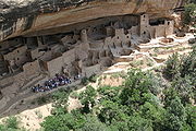 |
Mesa Verde National Park Mesa Verde National Park Mesa Verde National Park is a U.S. National Park and UNESCO World Heritage Site located in Montezuma County, Colorado, United States. It was created in 1906 to protect some of the best-preserved cliff dwellings in the world... , a U.S. national park preserving over 4000 archaeological sites, including 600 cliff dwellings Cliff-dwelling Cliff dwelling is the general archaeological term for the habitations of prehistorical peoples, formed by using niches or caves in high cliffs, with more or less excavation or with additions in the way of masonry.... , of the Ancestral Pueblo people. |
Cortez to Hovenweep
| Begin | Highway | Directions | Photo | Comments |
|---|---|---|---|---|
| Cortez Cortez, Colorado The city of Cortez is a Home Rule Municipality that is the county seat and the most populous city of Montezuma County, Colorado, United States. The city population was 8,482 at the 2010 census... |
CO-145 / Colorado State Highway 184 Colorado State Highway 184 State Highway 184 is a long state highway in the southwestern corner of Colorado.-Route description:SH 184 begins in the west at its junction with US 491 near Lewis and travels ESE to Mancos... |
Travel north on CO-145 for 8 miles to Dolores. Turn left onto Colorado State Highway 184 Colorado State Highway 184 State Highway 184 is a long state highway in the southwestern corner of Colorado.-Route description:SH 184 begins in the west at its junction with US 491 near Lewis and travels ESE to Mancos... and travel 1.4 miles to the Anasazi Heritage Center. |
The Anasazi Heritage Center Anasazi Heritage Center Anasazi Heritage Center, located in Dolores, Colorado, is an archaeological museum of Native American pueblo and hunter-gatherer cultures. Two 12th-century archaeological sites, the Escalante and Dominguez Pueblos, at the center were once home to Ancient Pueblo Peoples... , a museum of the Ancient Pueblo (or Anasazi) culture and other Native cultures in the Four Corners region. Also visit the Escalante and Dominguez Pueblos on the center's site. As the Canyons of the Ancients National Monument Canyons of the Ancients National Monument Canyons of the Ancients National Monument is located in the southwestern region of the U.S. state of Colorado, and is managed by the U.S. Bureau of Land Management, an agency within the U.S. Department of the Interior... visitor center, you may also pick up information for Lowry Pueblo Lowry Pueblo The Lowry Pueblo is an Ancestral Puebloan archaeological site located in Canyons of the Ancients National Monument near Pleasant View, Colorado, United States. The pueblo was constructed about 1060 AD atop abandoned pithouses from an earlier period of occupation. It was occupied by 100 people... and other Canyons of the Ancients site. |
|
| Anasazi Heritage Center Anasazi Heritage Center Anasazi Heritage Center, located in Dolores, Colorado, is an archaeological museum of Native American pueblo and hunter-gatherer cultures. Two 12th-century archaeological sites, the Escalante and Dominguez Pueblos, at the center were once home to Ancient Pueblo Peoples... |
Colorado State Highway 184 Colorado State Highway 184 State Highway 184 is a long state highway in the southwestern corner of Colorado.-Route description:SH 184 begins in the west at its junction with US 491 near Lewis and travels ESE to Mancos... |
Continue on Colorado State Highway 184 Colorado State Highway 184 State Highway 184 is a long state highway in the southwestern corner of Colorado.-Route description:SH 184 begins in the west at its junction with US 491 near Lewis and travels ESE to Mancos... 6.6 miles to the highway's terminus at U.S. 491. |
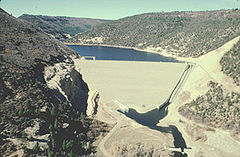 |
McPhee Reservoir McPhee Reservoir McPhee Reservoir is located in Montezuma County, Colorado, United States. It is the second largest artificial body of water in Colorado. It was constructed and is operated by the United States Bureau of Reclamation as part of the Dolores Project, and dams the Dolores River to furnish irrigation... , located off of Colorado State Highway 184 Colorado State Highway 184 State Highway 184 is a long state highway in the southwestern corner of Colorado.-Route description:SH 184 begins in the west at its junction with US 491 near Lewis and travels ESE to Mancos... , is visible from the Anasazi Heritage Center. |
| Junction of Colorado State Highway 184 Colorado State Highway 184 State Highway 184 is a long state highway in the southwestern corner of Colorado.-Route description:SH 184 begins in the west at its junction with US 491 near Lewis and travels ESE to Mancos... / U.S. 491 |
U.S. 491 | Travel north for 9 miles, passing through Lewis Lewis, Colorado Lewis is an unincorporated town and a U.S. Post Office in Montezuma County, Colorado, United States. The Lewis Post Office has the ZIP Code 81327.... and Yellow Jacket Yellow Jacket, Colorado Yellow Jacket is an unincorporated town and a U.S. Post Office located in Montezuma County, Colorado, United States. The Yellow Jacket Post Office has the ZIP Code 81335.-Geography:Yellow Jacket is located at .-History:... to Montezuma County Road CC, just south of Pleasant View Pleasant View, Colorado Pleasant View is an unincorporated town and a U.S. Post Office located in Montezuma County, Colorado, United States. The Pleasant View Post Office has the ZIP Code 81331.... . |
This is the beginning of the Canyons of the Ancients National Monument Canyons of the Ancients National Monument Canyons of the Ancients National Monument is located in the southwestern region of the U.S. state of Colorado, and is managed by the U.S. Bureau of Land Management, an agency within the U.S. Department of the Interior... . |
|
| Junction of U.S. 491 and Montezuma County Road CC. | Montezuma County Road CC | Travel west on Montezuma County Road CC for 8 miles towards Lowry Pueblo Lowry Pueblo The Lowry Pueblo is an Ancestral Puebloan archaeological site located in Canyons of the Ancients National Monument near Pleasant View, Colorado, United States. The pueblo was constructed about 1060 AD atop abandoned pithouses from an earlier period of occupation. It was occupied by 100 people... . |
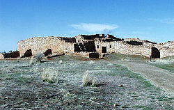 |
This section of the byway crosses parts of the Old Spanish National Historic Trail, a historic trade route connecting Santa Fe Santa Fe, New Mexico Santa Fe is the capital of the U.S. state of New Mexico. It is the fourth-largest city in the state and is the seat of . Santa Fe had a population of 67,947 in the 2010 census... with Los Angeles Los Angeles, California Los Angeles , with a population at the 2010 United States Census of 3,792,621, is the most populous city in California, USA and the second most populous in the United States, after New York City. It has an area of , and is located in Southern California... . Lowry Pueblo Lowry Pueblo The Lowry Pueblo is an Ancestral Puebloan archaeological site located in Canyons of the Ancients National Monument near Pleasant View, Colorado, United States. The pueblo was constructed about 1060 AD atop abandoned pithouses from an earlier period of occupation. It was occupied by 100 people... is a National Historic Landmark National Historic Landmark A National Historic Landmark is a building, site, structure, object, or district, that is officially recognized by the United States government for its historical significance... originally excavated in the 1930s and dating to around 1060 AD. The pueblo is part of Canyon of the Ancients National Monument, a Bureau of Land Management Bureau of Land Management The Bureau of Land Management is an agency within the United States Department of the Interior which administers America's public lands, totaling approximately , or one-eighth of the landmass of the country. The BLM also manages of subsurface mineral estate underlying federal, state and private... site encompassing over 6000 archaeological ruins over 183,000 acres. |
| Lowry Pueblo Lowry Pueblo The Lowry Pueblo is an Ancestral Puebloan archaeological site located in Canyons of the Ancients National Monument near Pleasant View, Colorado, United States. The pueblo was constructed about 1060 AD atop abandoned pithouses from an earlier period of occupation. It was occupied by 100 people... |
Montezuma County Road CC / Montezuma County Road 10 | Return east on Montezuma County Road CC 2.9 miles to Montezuma County Road 10. Travel south and west on Montezuma County Road 10, through the Canyon of the Ancients, for 17.5 miles, before reaching the Utah state line, where it becomes San Juan County Road 212 (Hovenweep Road). |  |
The route passes some of the outlying sites of Hovenweep National Monument Hovenweep National Monument Hovenweep National Monument is located on land in southwestern Colorado and southeastern Utah, located between Cortez, Colorado and Blanding, Utah on the Cajon Mesa of the Great Sage Plain... |
| Colorado / Utah state line | San Juan County Road 212 (Hovenweep Road) | The road turns south and intersects with the main entrance to Hovenweep 3.3 miles past the Colorado-Utah border. | Hovenweep National Monument Hovenweep National Monument Hovenweep National Monument is located on land in southwestern Colorado and southeastern Utah, located between Cortez, Colorado and Blanding, Utah on the Cajon Mesa of the Great Sage Plain... preserves six different sites in Utah and Colorado of Ancestral Puebloan settlements, many skillfully constructed in and on canyon walls and ledges. |
|
Hovenweep to Bluff and Blanding
| Begin | Highway | Directions | Photo | Comments |
|---|---|---|---|---|
| Hovenweep National Monument Visitor Center | Hovenweep Road | Heads west from the monument along Hovenweep Road for 30 miles. Hovenweep Road is multiple roads along the 30 miles: CR 212, CR 413, Reservation Road and UT 262. Travel to the junction with U.S. Route 191 U.S. Route 191 in Utah U.S. Route 191 is a major north–south state highway through the eastern part of the U.S. state of Utah. The present alignment of US-191, which stretches from Mexico to Canada, was created in 1981 through Utah... . |
||
| Junction of Utah 262 and U.S. Route 191 U.S. Route 191 in Utah U.S. Route 191 is a major north–south state highway through the eastern part of the U.S. state of Utah. The present alignment of US-191, which stretches from Mexico to Canada, was created in 1981 through Utah... |
U.S. Route 191 U.S. Route 191 in Utah U.S. Route 191 is a major north–south state highway through the eastern part of the U.S. state of Utah. The present alignment of US-191, which stretches from Mexico to Canada, was created in 1981 through Utah... |
Travel northern 15 miles to Blanding Blanding, Utah Blanding is a city in San Juan County, Utah, United States. The population was 3,162 at the 2000 census, making it the most populated city in San Juan County. It was settled in the late 19th century by Mormon settlers, predominantly from the famed Hole-In-The-Rock expedition... . |
Blanding is one of the most populous cities in southeastern Utah. Nearby Edge of the Cedars State Park Edge of the Cedars State Park Edge of the Cedars State Park Museum is a state park and museum of Utah, USA, located in Blanding. It is an Ancestral Puebloan archaeological site, a museum, and an archaeological repository... (660 West 400 North)includes some Anasazi ruins, a museum, and some very-well preserved artifacts, giving visitors a detailed view of how the Ancestral Puebloan lived and worked. |
|
Blanding to Natural Bridges
| Begin | Highway | Directions | Photo | Comments |
|---|---|---|---|---|
| Blanding Blanding, Utah Blanding is a city in San Juan County, Utah, United States. The population was 3,162 at the 2000 census, making it the most populated city in San Juan County. It was settled in the late 19th century by Mormon settlers, predominantly from the famed Hole-In-The-Rock expedition... |
U.S. Route 191 U.S. Route 191 in Utah U.S. Route 191 is a major north–south state highway through the eastern part of the U.S. state of Utah. The present alignment of US-191, which stretches from Mexico to Canada, was created in 1981 through Utah... |
Travel 4 miles south on U.S. Route 191 U.S. Route 191 in Utah U.S. Route 191 is a major north–south state highway through the eastern part of the U.S. state of Utah. The present alignment of US-191, which stretches from Mexico to Canada, was created in 1981 through Utah... to Utah State Route 95, and |
||
| Junction of U.S. Route 191 U.S. Route 191 in Utah U.S. Route 191 is a major north–south state highway through the eastern part of the U.S. state of Utah. The present alignment of US-191, which stretches from Mexico to Canada, was created in 1981 through Utah... and Utah State Route 95 |
Utah State Route 95 | Head west 30 miles to Utah State Route 275. | 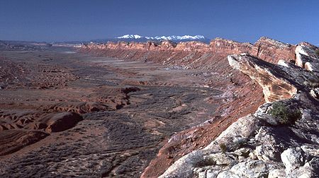 |
About 14 miles on Utah State Route 95 are turn offs for Comb Ridge Comb Ridge Comb Ridge is a linear north to south-trending monocline nearly 120 miles long in southeast Utah and Arizona. Composed of Jurassic-age Navajo Sandstone, it displays massive eolian cross-bedding.... and Comb Wash. The route ascends the eastern side of Cedar Mesa. Nearby ruins include the partially reconstructed Mule Canyon Ruin and the Butler Wash cliff dwellings. |
| Junction of Utah State Route 95 and Utah State Route 275 | Utah State Route 275 | Travel 4 miles to the entrance to Natural Bridges National Monument Natural Bridges National Monument Natural Bridges National Monument is a U.S. National Monument located about north west of the Four Corners boundary of southeast Utah, in the western United States, at the junction of White Canyon and Armstrong Canyon, part of the Colorado River drainage... . |
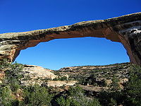 |
The easily driveable park loop road takes visitors past three of the largest natural bridges in the world. |
Grand Gulch to Monument Valley
| Begin | Highway | Directions | Photo | Comments |
|---|---|---|---|---|
| Natural Bridges National Monument. | UT-275 | Travel 4 miles east on UT 275 to UT-95 | |
|
| Junction of UT 275 to UT-95 | UT-95 | Travel 2 miles on UT-95 to Utah State Route 261 | ||
| Junction of UT-95 and Utah State Route 261 | Utah State Route 261 | Heads south for 33 miles to U.S. Route 163 U.S. Route 163 U.S. Route 163 is a U.S. Highway that runs from US 160 northward to US 191 in the U.S. states of Arizona and Utah. The southernmost of its length is within the Navajo Nation. The highway forms part of the Trail of the Ancients, a National Scenic Byway... |
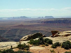 |
The first half of this section of the byway courses along the top of Cedar Mesa, with turnoffs to Cedar Point and Muley Point Muley Point Muley Point is a remote, scenic overlook in southern Utah near Mexican Hat. The view provides panoramic vistas of the desert landscape of southern Utah and northern Arizona. Monument Valley is visible in the distance while the San Juan River cuts into the canyon below.Located at the end of a five... , parts of the Glen Canyon National Recreation Area Glen Canyon National Recreation Area Glen Canyon National Recreation Area is a recreation and conservation unit of the National Park Service that encompasses the area around Lake Powell and lower Cataract Canyon in Utah and Arizona, covering 1,254,429 acres of mostly desert... overlooking the San Juan River. The route descends Cedar Mesa at Moki Dugway, a steep grade dropping 1000 feet in 3 miles, and enters the Valley of the Gods Valley of the Gods Valley of the Gods is a scenic sandstone valley near Mexican Hat in San Juan County, southeastern Utah. It is north of Monument Valley across the San Juan River , and has similar rock formations... . A few miles through the valley is the turnoff for Goosenecks State Park Goosenecks State Park Goosenecks State Park is a state park of Utah, USA, overlooking a deep meander of the San Juan River. The park is located near the southern border of the state a short distance from Mexican Hat, Utah. Millions of years ago, the Monument Upwarp forced the river to carve incised meanders over deep... ; shortly after, UT-261 ends at U.S. Route 163 U.S. Route 163 U.S. Route 163 is a U.S. Highway that runs from US 160 northward to US 191 in the U.S. states of Arizona and Utah. The southernmost of its length is within the Navajo Nation. The highway forms part of the Trail of the Ancients, a National Scenic Byway... . |
| Junction of Utah State Route 261 and U.S. Route 163 U.S. Route 163 U.S. Route 163 is a U.S. Highway that runs from US 160 northward to US 191 in the U.S. states of Arizona and Utah. The southernmost of its length is within the Navajo Nation. The highway forms part of the Trail of the Ancients, a National Scenic Byway... |
U.S. Route 163 U.S. Route 163 U.S. Route 163 is a U.S. Highway that runs from US 160 northward to US 191 in the U.S. states of Arizona and Utah. The southernmost of its length is within the Navajo Nation. The highway forms part of the Trail of the Ancients, a National Scenic Byway... |
Travel south 25 miles to the Utah / Arizona state border towards Monument Valley. | 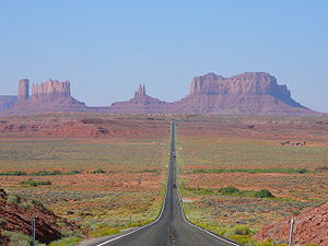 |
Passing through the town of Mexican Hat Mexican Hat, Utah Mexican Hat is a census-designated place on the San Juan River in south-central San Juan County, Utah, United States. Each year, on March 8 the town members meet to celebrate their CDP status. Town members wear hats, as the celebration takes place at the Mexican Hat Rock. It is on U.S... , so named for the unique rock formation north of the city, the byway crosses the San Juan River, reentering Navajo Nation. This stretch of the byway ends at Monument Valley Monument Valley Monument Valley is a region of the Colorado Plateau characterized by a cluster of vast sandstone buttes, the largest reaching above the valley floor. It is located on the northern border of Arizona with southern Utah , near the Four Corners area... , a Navajo Tribal Park known for its appearance in films, commercials, and other media. |
Mexican Hat to Four Corners
| Begin | Highway | Directions | Photo | Comments |
|---|---|---|---|---|
| Mexican Hat | U.S. Route 163 | Travel north on U.S. Route 163 for 21 miles. | ||
| Where U.S. Route 163 becomes U.S. Route 191 U.S. Route 191 U.S. Route 191 is a spur of U.S. Route 91 that has two branches. The southern branch runs for 1,465 miles from Douglas, Arizona on the Mexican border to the southern part of Yellowstone National Park. The northern branch runs for 440 miles from the northern part of Yellowstone National Park to... |
U.S. Route 163 / U.S. Route 191 U.S. Route 191 U.S. Route 191 is a spur of U.S. Route 91 that has two branches. The southern branch runs for 1,465 miles from Douglas, Arizona on the Mexican border to the southern part of Yellowstone National Park. The northern branch runs for 440 miles from the northern part of Yellowstone National Park to... |
Travel five miles on U.S. Route 191 U.S. Route 191 U.S. Route 191 is a spur of U.S. Route 91 that has two branches. The southern branch runs for 1,465 miles from Douglas, Arizona on the Mexican border to the southern part of Yellowstone National Park. The northern branch runs for 440 miles from the northern part of Yellowstone National Park to... |
||
| Bluff Bluff, Utah Bluff is a census-designated place in San Juan County, Utah, United States. The population was 320 at the 2000 census.-Geography:Bluff is located at , in the scenic and very sparsely populated southeastern Utah canyonlands of the Colorado Plateau.According to the United States Census Bureau, the... |
Utah State Route 162 Utah State Route 162 State Route 162 is a state highway located in San Juan County, Utah. It begins at US-191 east of Bluff. It then follows the former alignment of SR-163 to Montezuma Creek. There, it intersects UT-262 at its southern terminus. Afterwards, it follows SR-262's former alignment past Aneth to the... / CO-41. |
Travel east 27 miles on Utah State Route 162 Utah State Route 162 State Route 162 is a state highway located in San Juan County, Utah. It begins at US-191 east of Bluff. It then follows the former alignment of SR-163 to Montezuma Creek. There, it intersects UT-262 at its southern terminus. Afterwards, it follows SR-262's former alignment past Aneth to the... and at the Utah-Colorado border CO-41 to |
 |
Bordering the San Juan River and passing through Montezuma Creek, UT and Aneth, UT, Utah State Route 162 Utah State Route 162 State Route 162 is a state highway located in San Juan County, Utah. It begins at US-191 east of Bluff. It then follows the former alignment of SR-163 to Montezuma Creek. There, it intersects UT-262 at its southern terminus. Afterwards, it follows SR-262's former alignment past Aneth to the... becomes CO-41 at the Colorado border. |
| Junction of CO-41 and U.S. 160 | U.S. 160 | Travel southwest to the Four Corners about five miles to Four Corners. | ||
San Juan Skyway
The 16-mile section of the Trail of the Ancients from Mesa Verde to the junction of CO-145 and CO-184 west of Dolores is part of the San Juan Skyway, a National Scenic Byway also designated as an All-American RoadNational Scenic Byway
A National Scenic Byway is a road recognized by the United States Department of Transportation for its archeological, cultural, historic, natural, recreational, and/or scenic qualities. The program was established by Congress in 1991 to preserve and protect the nation's scenic but often...
.