

U.S. Route 163
Encyclopedia
U.S. Route 163 is a 64 miles (103 km) U.S. Highway
that runs from US 160 northward to US 191
in the U.S. state
s of Arizona
and Utah
. The southernmost 44 miles (70.8 km) of its length is within the Navajo Nation
. The highway forms part of the Trail of the Ancients
, a National Scenic Byway
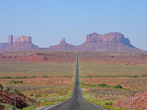
. The highway cuts through the heart of Monument Valley
and has been featured in numerous movies and commercials.
The highway was designated in 1970, replacing Arizona State Route 464 and Utah State Route 47 as well as a portion of the old alignment of US 160
in Utah. In 1981, US 191
was routed over the northern section of US 163, effectively truncating the northern terminus to Bluff, Utah
from Crescent Junction
. The state of Utah initially had plans for a different routing of US 163 north of Bluff. These plans were rejected, resulting in discrepancies between the signed route and the official designation by the American Association of State Highway and Transportation Officials
that were not resolved until 2008. The route number does not follow the normal numbering convention for U.S. highways, as the number 163 would normally be used for a spur of U.S. Route 63
; however, these two highways have never connected.
in Navajo County
and Navajo Nation
. The road continues to the south of this junction as Bureau of Indian Affairs
(BIA) Route 591. US 163 heads north from US 160 to the west of the Kayenta Airport
as it passes through the town of Kayenta
. The highway curves towards the northeast in Kayenta before it curves back towards the north. As it continues towards the north, the highway goes through an s-curve, resulting in a northeasterly heading. US 163 continues this heading as it heads toward Monument Valley
and crosses the border into Utah. An 18 miles (29 km) stretch of the highway from approximately 5 miles (8 km) north of the US 160 junction to the Utah border has been designated as a scenic route by the state of Arizona.
. Just after entering Utah the highway junctions with the Monument Valley Visitors center. The highway proceeds northeast until the town of Mexican Hat
where the highway both crosses the San Juan River and exits the Navajo Nation
. From Mexican Hat, the highway travels due east to towards its signed terminus in Bluff
. Formerly, the route continued along what is now signed US 191 to I-70
, however the portion north of Bluff was not signed after the creation of US 191 and was formally removed in 2008. The length of US 163 in Utah has been designated the Bluff to Monument Valley Scenic byway by the Utah State Legislature
and forms part of the Trail of the Ancients National Scenic Byway
. All highways in Utah are codified in law; US 163 is defined at Utah Code §72-4-122(3).
at a junction with then U.S. Route 160
. In Arizona, the road appeared on maps as early as 1935, but it was still an unimproved dirt road at the time. The Arizona portion was added to the state highway system in 1960 when it was designated as State Route 464.
In 1970, US 163 was designated along SR 464 in Arizona and SR 47 in Utah as part of a re-alignment of U.S. highways in the Four Corners region. With the re-alignment, US 160 was re-routed into Arizona instead of Utah. US 163 also absorbed the former route of US 160 to its former terminus at Interstate 70 at Crescent Junction
. In 1981, AASHTO approved a new iteration of U.S. Route 191
that absorbed much of the alignment of US 163. Utah truncated US 163 at Bluff
. The truncation was made without approval from AASHTO, as the AASHTO logs placed the northern terminus of US 163 at I-70 at Crescent Junction.
 The state of Utah signed a joint intent with the Navajo Nation
and San Juan County
in 1986 to construct a new highway to connect Bluff
with Montezuma Creek
. Businesses in Monument Valley asked the Utah Department of Transportation (UDOT) to request extensions of US 163 and US 666 using this new road. The proposal would have US 163 run from Cedar City
to US 160 near Cortez, Colorado
along the routes of State Route 14
, U.S. Route 89
, Arizona State Route 98
, U.S. Route 160
, the current US 163, the new road from Bluff to Montezuma Creek, and Colorado State Highway 41
. The proposal for US 666 would extend to Richfield
via upgrades to State Route 95 and State Route 24
. UDOT submitted the proposal for US 666 to AASHTO, which was rejected. AASHTO cited that the route was not direct, and SR-24 was not built to U.S. Highway standards. UDOT did not pursue the extension of US 163, even though the Utah state legislature had already approved the new road from Bluff to Montezuma creek as route 163.
With this extension the Utah definition of US 163 conflicted with the AASHTO definition. UDOT resolved this discrepancy by signing the extended portion as State Route 163. In 2004, the plan to extend US 163 was abandoned, and the extension was renumbered SR-162
to "make the state route numbers run synonymous with the U.S. route designation." Although the state changed the definition of US 163 back to match the national definition in 2004, the portion north of Bluff remained unsigned. In October 2008, UDOT requested and obtained approval to truncate US 163 to the junction with US 191.
!County
!Location
!Mile
!Junction
!Notes
|-
|rowspan=2|Navajo County
|
|0.00
|, Four Corners
|
|-
|rowspan=2|
|rowspan=2|23.21
0.000
|rowspan=2|Arizona
/ Utah
State Line
|rowspan=2|
|-
|rowspan=4|San Juan County
|-
|
|0.458
| Navajo / BIA route 42 – Monument Valley
Tribal Park Visitors Center
|
|-
|
|24.847
| – Goosenecks State Park
, Valley of the Gods
|
|-
|
|41.405
|, Mexican Water, AZ
|
United States Numbered Highways
The system of United States Numbered Highways is an integrated system of roads and highways in the United States numbered within a nationwide grid...
that runs from US 160 northward to US 191
U.S. Route 191 in Utah
U.S. Route 191 is a major north–south state highway through the eastern part of the U.S. state of Utah. The present alignment of US-191, which stretches from Mexico to Canada, was created in 1981 through Utah...
in the U.S. state
U.S. state
A U.S. state is any one of the 50 federated states of the United States of America that share sovereignty with the federal government. Because of this shared sovereignty, an American is a citizen both of the federal entity and of his or her state of domicile. Four states use the official title of...
s of Arizona
Arizona
Arizona ; is a state located in the southwestern region of the United States. It is also part of the western United States and the mountain west. The capital and largest city is Phoenix...
and Utah
Utah
Utah is a state in the Western United States. It was the 45th state to join the Union, on January 4, 1896. Approximately 80% of Utah's 2,763,885 people live along the Wasatch Front, centering on Salt Lake City. This leaves vast expanses of the state nearly uninhabited, making the population the...
. The southernmost 44 miles (70.8 km) of its length is within the Navajo Nation
Navajo Nation
The Navajo Nation is a semi-autonomous Native American-governed territory covering , occupying all of northeastern Arizona, the southeastern portion of Utah, and northwestern New Mexico...
. The highway forms part of the Trail of the Ancients
Trail of the Ancients
The Trail of the Ancients is an National Scenic Byway located in the states of Colorado and Utah. The route highlights the archaeological and cultural history of southwestern Native American peoples, and traverses the widely diverse geological landscape of the Four Corners region...
, a National Scenic Byway
National Scenic Byway
A National Scenic Byway is a road recognized by the United States Department of Transportation for its archeological, cultural, historic, natural, recreational, and/or scenic qualities. The program was established by Congress in 1991 to preserve and protect the nation's scenic but often...
. The highway cuts through the heart of Monument Valley
Monument Valley
Monument Valley is a region of the Colorado Plateau characterized by a cluster of vast sandstone buttes, the largest reaching above the valley floor. It is located on the northern border of Arizona with southern Utah , near the Four Corners area...
and has been featured in numerous movies and commercials.
The highway was designated in 1970, replacing Arizona State Route 464 and Utah State Route 47 as well as a portion of the old alignment of US 160
U.S. Route 160
U.S. Route 160 is a 1,465 mile long east–west United States highway in the Midwestern United States. The western terminus of the route is at U.S. Route 89 five miles west of Tuba City, Arizona. The eastern terminus is at U.S...
in Utah. In 1981, US 191
U.S. Route 191
U.S. Route 191 is a spur of U.S. Route 91 that has two branches. The southern branch runs for 1,465 miles from Douglas, Arizona on the Mexican border to the southern part of Yellowstone National Park. The northern branch runs for 440 miles from the northern part of Yellowstone National Park to...
was routed over the northern section of US 163, effectively truncating the northern terminus to Bluff, Utah
Bluff, Utah
Bluff is a census-designated place in San Juan County, Utah, United States. The population was 320 at the 2000 census.-Geography:Bluff is located at , in the scenic and very sparsely populated southeastern Utah canyonlands of the Colorado Plateau.According to the United States Census Bureau, the...
from Crescent Junction
Crescent Junction, Utah
Crescent Junction is a small unincorporated community within Grand County in the eastern part of the U.S. state of Utah. The community is located at above sea level. Most highway maps use the name Crescent Junction, as the name given to the junction of Interstate 70 and U.S. Route 191...
. The state of Utah initially had plans for a different routing of US 163 north of Bluff. These plans were rejected, resulting in discrepancies between the signed route and the official designation by the American Association of State Highway and Transportation Officials
American Association of State Highway and Transportation Officials
AASHTO, the American Association of State Highway and Transportation Officials, is a standards setting body which publishes specifications, test protocols and guidelines which are used in highway design and construction throughout the United States...
that were not resolved until 2008. The route number does not follow the normal numbering convention for U.S. highways, as the number 163 would normally be used for a spur of U.S. Route 63
U.S. Route 63
U.S. Route 63 is a long north–south United States highway primarily in the Midwestern United States. The southern terminus of the route is at Interstate 20 in Ruston, Louisiana. The northern terminus is at U.S. Route 2 in Benoit, Wisconsin, about east of Duluth, Minnesota. It is not related to U.S...
; however, these two highways have never connected.
Arizona
The southern terminus of US 163 is located at a junction with US 160 south of KayentaKayenta, Arizona
Kayenta is a census-designated place which is part of the Navajo Nation and is in Navajo County, Arizona, United States. The population was 5,189 at the 2010 census. Kayenta is located south of Monument Valley and contains a number of hotels and motels which service visitors to Monument...
in Navajo County
Navajo County, Arizona
-2010:Whereas according to the 2010 U.S. Census Bureau:*49.3% White*0.9% Black*43.4% Native American*0.5% Asian*0.1% Native Hawaiian or Pacific Islander*2.5% Two or more races*3.3% Other races*10.8% Hispanic or Latino -2000:...
and Navajo Nation
Navajo Nation
The Navajo Nation is a semi-autonomous Native American-governed territory covering , occupying all of northeastern Arizona, the southeastern portion of Utah, and northwestern New Mexico...
. The road continues to the south of this junction as Bureau of Indian Affairs
Bureau of Indian Affairs
The Bureau of Indian Affairs is an agency of the federal government of the United States within the US Department of the Interior. It is responsible for the administration and management of of land held in trust by the United States for Native Americans in the United States, Native American...
(BIA) Route 591. US 163 heads north from US 160 to the west of the Kayenta Airport
Kayenta Airport
Kayenta Airport is a public-use airport located two nautical miles southeast of the central business district of Kayenta, in Navajo County, Arizona, United States...
as it passes through the town of Kayenta
Kayenta, Arizona
Kayenta is a census-designated place which is part of the Navajo Nation and is in Navajo County, Arizona, United States. The population was 5,189 at the 2010 census. Kayenta is located south of Monument Valley and contains a number of hotels and motels which service visitors to Monument...
. The highway curves towards the northeast in Kayenta before it curves back towards the north. As it continues towards the north, the highway goes through an s-curve, resulting in a northeasterly heading. US 163 continues this heading as it heads toward Monument Valley
Monument Valley
Monument Valley is a region of the Colorado Plateau characterized by a cluster of vast sandstone buttes, the largest reaching above the valley floor. It is located on the northern border of Arizona with southern Utah , near the Four Corners area...
and crosses the border into Utah. An 18 miles (29 km) stretch of the highway from approximately 5 miles (8 km) north of the US 160 junction to the Utah border has been designated as a scenic route by the state of Arizona.
Utah
The Utah portion of the highway begins in Monument Valley, in San Juan CountySan Juan County, Utah
As of the current census of 2010, there were 14,746 people and 4,505 households. The racial and ethnic composition of the population was 50.4% Native American, 45.8% white, 0.3% Asian, 0.2% African American and 2.3% reporting two or more races...
. Just after entering Utah the highway junctions with the Monument Valley Visitors center. The highway proceeds northeast until the town of Mexican Hat
Mexican Hat, Utah
Mexican Hat is a census-designated place on the San Juan River in south-central San Juan County, Utah, United States. Each year, on March 8 the town members meet to celebrate their CDP status. Town members wear hats, as the celebration takes place at the Mexican Hat Rock. It is on U.S...
where the highway both crosses the San Juan River and exits the Navajo Nation
Navajo Nation
The Navajo Nation is a semi-autonomous Native American-governed territory covering , occupying all of northeastern Arizona, the southeastern portion of Utah, and northwestern New Mexico...
. From Mexican Hat, the highway travels due east to towards its signed terminus in Bluff
Bluff, Utah
Bluff is a census-designated place in San Juan County, Utah, United States. The population was 320 at the 2000 census.-Geography:Bluff is located at , in the scenic and very sparsely populated southeastern Utah canyonlands of the Colorado Plateau.According to the United States Census Bureau, the...
. Formerly, the route continued along what is now signed US 191 to I-70
Interstate 70 in Utah
Interstate 70 is a mainline route of the Interstate Highway System in the United States connecting Utah and Maryland. The Utah section runs east–west for across the central part of the state. Richfield is the largest Utah city served by the freeway, which does not serve or connect any urban areas...
, however the portion north of Bluff was not signed after the creation of US 191 and was formally removed in 2008. The length of US 163 in Utah has been designated the Bluff to Monument Valley Scenic byway by the Utah State Legislature
Utah State Legislature
The Utah State Legislature is the state legislature of the U.S. state of Utah. It is a bicameral body, comprising the Utah House of Representatives, with 75 Representatives, and the Utah Senate, with 29 State Senators...
and forms part of the Trail of the Ancients National Scenic Byway
National Scenic Byway
A National Scenic Byway is a road recognized by the United States Department of Transportation for its archeological, cultural, historic, natural, recreational, and/or scenic qualities. The program was established by Congress in 1991 to preserve and protect the nation's scenic but often...
. All highways in Utah are codified in law; US 163 is defined at Utah Code §72-4-122(3).
History
The modern routing of US 163 in Utah was initially designated as State Route 47, in 1910. SR 47 extended to MonticelloMonticello, Utah
Monticello is a city located in San Juan County, Utah, and is the county seat. It is the second most populous city in San Juan County, with a population of 1,958 at the 2000 census. The Monticello area was settled in July 1887 by pioneers from The Church of Jesus Christ of Latter-day Saints...
at a junction with then U.S. Route 160
U.S. Route 160
U.S. Route 160 is a 1,465 mile long east–west United States highway in the Midwestern United States. The western terminus of the route is at U.S. Route 89 five miles west of Tuba City, Arizona. The eastern terminus is at U.S...
. In Arizona, the road appeared on maps as early as 1935, but it was still an unimproved dirt road at the time. The Arizona portion was added to the state highway system in 1960 when it was designated as State Route 464.
In 1970, US 163 was designated along SR 464 in Arizona and SR 47 in Utah as part of a re-alignment of U.S. highways in the Four Corners region. With the re-alignment, US 160 was re-routed into Arizona instead of Utah. US 163 also absorbed the former route of US 160 to its former terminus at Interstate 70 at Crescent Junction
Crescent Junction, Utah
Crescent Junction is a small unincorporated community within Grand County in the eastern part of the U.S. state of Utah. The community is located at above sea level. Most highway maps use the name Crescent Junction, as the name given to the junction of Interstate 70 and U.S. Route 191...
. In 1981, AASHTO approved a new iteration of U.S. Route 191
U.S. Route 191
U.S. Route 191 is a spur of U.S. Route 91 that has two branches. The southern branch runs for 1,465 miles from Douglas, Arizona on the Mexican border to the southern part of Yellowstone National Park. The northern branch runs for 440 miles from the northern part of Yellowstone National Park to...
that absorbed much of the alignment of US 163. Utah truncated US 163 at Bluff
Bluff, Utah
Bluff is a census-designated place in San Juan County, Utah, United States. The population was 320 at the 2000 census.-Geography:Bluff is located at , in the scenic and very sparsely populated southeastern Utah canyonlands of the Colorado Plateau.According to the United States Census Bureau, the...
. The truncation was made without approval from AASHTO, as the AASHTO logs placed the northern terminus of US 163 at I-70 at Crescent Junction.
Navajo Nation
The Navajo Nation is a semi-autonomous Native American-governed territory covering , occupying all of northeastern Arizona, the southeastern portion of Utah, and northwestern New Mexico...
and San Juan County
San Juan County, Utah
As of the current census of 2010, there were 14,746 people and 4,505 households. The racial and ethnic composition of the population was 50.4% Native American, 45.8% white, 0.3% Asian, 0.2% African American and 2.3% reporting two or more races...
in 1986 to construct a new highway to connect Bluff
Bluff, Utah
Bluff is a census-designated place in San Juan County, Utah, United States. The population was 320 at the 2000 census.-Geography:Bluff is located at , in the scenic and very sparsely populated southeastern Utah canyonlands of the Colorado Plateau.According to the United States Census Bureau, the...
with Montezuma Creek
Montezuma Creek, Utah
Montezuma Creek is a census-designated place in San Juan County, Utah, United States. The population was 507 at the 2000 census, a large increase over the 1990 figure of 345.-Education:...
. Businesses in Monument Valley asked the Utah Department of Transportation (UDOT) to request extensions of US 163 and US 666 using this new road. The proposal would have US 163 run from Cedar City
Cedar City, Utah
As of the census of 2000, there were 20,527 people, 6,486 households, and 4,682 families residing in the city. The population density was 1,021.8 people per square mile . There were 7,109 housing units at an average density of 353.9 per square mile...
to US 160 near Cortez, Colorado
Cortez, Colorado
The city of Cortez is a Home Rule Municipality that is the county seat and the most populous city of Montezuma County, Colorado, United States. The city population was 8,482 at the 2010 census...
along the routes of State Route 14
Utah State Route 14
State Route 14 is a state highway in southern Utah, running for in Iron and Kane Counties from Cedar City to Long Valley Junction. The highway has been designated the Markagaunt High Plateau Scenic Byway as part of the Utah Scenic Byways program....
, U.S. Route 89
U.S. Route 89
U.S. Route 89 is a north–south United States Highway with two sections, and one former section. The southern section runs for 848 miles from Flagstaff, Arizona, to the southern entrance of Yellowstone National Park...
, Arizona State Route 98
Arizona State Route 98
State Route 98 is a state highway in Coconino County in the U.S. state of Arizona.-Route description:It runs from its junction with US 89 just south of Page to its junction with US 160 to the southeast...
, U.S. Route 160
U.S. Route 160
U.S. Route 160 is a 1,465 mile long east–west United States highway in the Midwestern United States. The western terminus of the route is at U.S. Route 89 five miles west of Tuba City, Arizona. The eastern terminus is at U.S...
, the current US 163, the new road from Bluff to Montezuma Creek, and Colorado State Highway 41
Colorado State Highway 41
State Highway 41 is a highway on the Ute Mountain Ute Indian Reservation in southwest Colorado.-Route description:SH 41 runs , starting at a junction with US-160 near the Four Corners Monument. The highway goes northwest and ends at the Utah state line...
. The proposal for US 666 would extend to Richfield
Richfield, Utah
Richfield is a city in and the county seat of Sevier County, Utah, in the United States, and is the largest city in southern-central Utah. As of the 2010 census, the city population was 7,551. It lies in the Mormon Corridor, just off of Interstate 70 about 40 miles east of its junction with...
via upgrades to State Route 95 and State Route 24
Utah State Route 24
State Route 24 is a state highway in south central Utah which runs south from Salina through Sevier County then east through Wayne County and north east through Emery County...
. UDOT submitted the proposal for US 666 to AASHTO, which was rejected. AASHTO cited that the route was not direct, and SR-24 was not built to U.S. Highway standards. UDOT did not pursue the extension of US 163, even though the Utah state legislature had already approved the new road from Bluff to Montezuma creek as route 163.
With this extension the Utah definition of US 163 conflicted with the AASHTO definition. UDOT resolved this discrepancy by signing the extended portion as State Route 163. In 2004, the plan to extend US 163 was abandoned, and the extension was renumbered SR-162
Utah State Route 162
State Route 162 is a state highway located in San Juan County, Utah. It begins at US-191 east of Bluff. It then follows the former alignment of SR-163 to Montezuma Creek. There, it intersects UT-262 at its southern terminus. Afterwards, it follows SR-262's former alignment past Aneth to the...
to "make the state route numbers run synonymous with the U.S. route designation." Although the state changed the definition of US 163 back to match the national definition in 2004, the portion north of Bluff remained unsigned. In October 2008, UDOT requested and obtained approval to truncate US 163 to the junction with US 191.
Junction list
{|class=wikitable!County
!Location
!Mile
!Junction
!Notes
|-
|rowspan=2|Navajo County
Navajo County, Arizona
-2010:Whereas according to the 2010 U.S. Census Bureau:*49.3% White*0.9% Black*43.4% Native American*0.5% Asian*0.1% Native Hawaiian or Pacific Islander*2.5% Two or more races*3.3% Other races*10.8% Hispanic or Latino -2000:...
|
|0.00
|, Four Corners
|
|-
|rowspan=2|
|rowspan=2|23.21
0.000
|rowspan=2|Arizona
Arizona
Arizona ; is a state located in the southwestern region of the United States. It is also part of the western United States and the mountain west. The capital and largest city is Phoenix...
/ Utah
Utah
Utah is a state in the Western United States. It was the 45th state to join the Union, on January 4, 1896. Approximately 80% of Utah's 2,763,885 people live along the Wasatch Front, centering on Salt Lake City. This leaves vast expanses of the state nearly uninhabited, making the population the...
State Line
|rowspan=2|
|-
|rowspan=4|San Juan County
San Juan County, Utah
As of the current census of 2010, there were 14,746 people and 4,505 households. The racial and ethnic composition of the population was 50.4% Native American, 45.8% white, 0.3% Asian, 0.2% African American and 2.3% reporting two or more races...
|-
|
|0.458
|
Navajo / BIA route 42 – Monument ValleyMonument Valley
Monument Valley is a region of the Colorado Plateau characterized by a cluster of vast sandstone buttes, the largest reaching above the valley floor. It is located on the northern border of Arizona with southern Utah , near the Four Corners area...
Tribal Park Visitors Center
|
|-
|
|24.847
| – Goosenecks State Park
Goosenecks State Park
Goosenecks State Park is a state park of Utah, USA, overlooking a deep meander of the San Juan River. The park is located near the southern border of the state a short distance from Mexican Hat, Utah. Millions of years ago, the Monument Upwarp forced the river to carve incised meanders over deep...
, Valley of the Gods
Valley of the Gods
Valley of the Gods is a scenic sandstone valley near Mexican Hat in San Juan County, southeastern Utah. It is north of Monument Valley across the San Juan River , and has similar rock formations...
|
|-
|
|41.405
|, Mexican Water, AZ
Mexican Water, Arizona
Mexican Water is an unincorporated community in Apache County, Arizona, United States. Mexican Water is located on the Navajo Nation west of Red Mesa....
|
See also
- List of appearances of Monument Valley in the media - US 163 is visible in several movies etc. filmed in Monument Valley